| OCR Text |
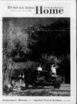
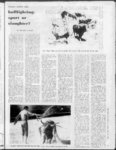
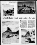
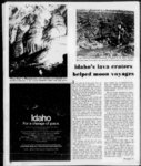
Show vast, weird and wonderful moonscape at Craters of the Moon National Monument near Arco, where one can walk across terrain or beneath surface . A lava craters helped moon voyages Mali Throne Room" in Minnetonka Cave, where stalactites and stalagmites have blended in limestone, is one of many formations in Bear Lake area cavern. If you cant go to the visit Idahos lunar moon, why not the . counterpart Craters of the Moon National Monument? Be like the astronauts who practiced shuffling across blackened cinder buttes, walking on hardened, swirling lava rivers or striding out onto the tortured terrain of the Blue Dragon Flow. The monument is a vast, weird, and era wonderful moonscape. Fujiyama-lik- e ters one is nearly 800 feet down to the contrast with closed volcano throat flat fields of jagged clinkers. Deep fissures show where, through the eons, boiling lava has overflowed again and again. lava tree molds indicate Skyward-poin- t that liquid magma once encased living trees, and underneath it all, tunnels and caves have floors of ice that last the year round. How was the landscape formed? For the answer stop at the Visitor Center, manned by the National Park Service who this year celebrate their 100th anniversary. The center contains a museum which furnishes an excellent series of exand photographs. hibits, illustrations These help explain the areas unique volcanic formation, plants, animals and its human history. Armed with a better understanding, one is ready to investigate on his own. To acquaint oneself vith the monue and the ment, take the s leading from it. The road skirts Paisley Cone, which like other cinder buttes are veritable flower gardens when the buckwheat, mimulus and bitterroot bloom about the Fourth of July. Devils Orchard is an area of broken crater wall, cinders and gnarled limber pines. A nature trail takes about 20 minutes to walk through an area loop-driv- side-trip- A. 34 itself. where wildlife has Along the trailside one might see the yellow-pin- e chipmunk, golden-mantle- d ground squirrel, chickaree and yellow-bellie- d marmot. The lava floods destroyed all vegetation in their paths. Evidence of this can be viewed along the tree-moltrail. It was here that a pahoehoe flow slowly enveloped a group of living trees. The lava cooled and hardened sufficiently upon contact with the moist wood to form tree molds. Smoothsided vertical molds mark the location of ancient tree trunks while horizontal charred wood molds indicate where tree tops fell onto the liquid lava. In the cave area one can walk beneath the surface and view the inside of a lava bubble or walk down a hollow tube through which lava once flowed. Walls of some are intricate with drippings. Others record the ebb and flow of the molten mass which drained out onto the plain. Some of these caves and tunnls were used by the Indians for protection. A campground a short distance inside the monument is open from about April 15 to October 15, where each evening in summer an illustrated program on the geology, plants or wildlife of the monument is given. For a change of pace take a trek along the Old Oregon Trail (Highway 30) into the land of the Todays modern highway follows in close proximity the trails of the which later became ruts etched by the great western-bounwagon trains. The Bear Lake country is the eastern gateway to the wealth of scenery and recreation that is Idaho. d Quee-yaw-a- fur-trad- er d (See page 37) |