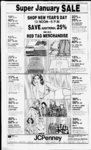
| OCR Text |
Show V DAVIS COUNTY CUPPER, DECEMBER 29, is j .03 n mol to N In of S W v4 of' sd sec 5, Th N 88 deg. 3944" E 389.17 ft alg sd N In; th S is deg. 49 33 E 550 ft to pob. Corn. 5.54 Acres subj to a R- W. Total Tax $299 92 Zions First Natl Bank. 02 007:0010, Beg at a ptwh is S 88 deg 44'34"W 615.34 ft & .1760 17 ft fr S' cor of Sec 5. T2N-R1E; SLM' th N 82 deg 52" 38 E 617 43 ft mol to E In ofSW'.ofsd Sec 5 ;Th SO deg 04'45 E 335 ft alg sd E In. th S 58 deg. 20 26" W 445 15 ft, th N 25 deg 27 14" W '44 99 ft to pob. Cont 5 12 Acres together with & subj to a R-- Total Tax . $162 60 Lockhart Co . 04 046 0008 Beg at a pt 1540 ft N & 1900 46 ft fr SE cor of Sec 21, T2N-R1SLM th VS 3 19 8' ft, th N 272 33 ft, th E 319 8' ft, th S 272 33 ft to pob Cont 2 00 $12 4' Acres Total Tax Lockhart Companv, 04 046 0009 & '80 62 ft W I r Beg '40 ft St cor of Sec 21, T2VRIE. SLM th W 1'9 92 ft th 272 33 It, th t 139 92 ft, th S 00 2'2 33 ft to pob Cont Acre also beg 1'40 ft 4 1740 '4 ft VV tr St cor of Sec 21. T2 Rif . SI M & run th W '9 92ft th N 272 33 0, th f 1'9 92 ft th S 22 33 ft to pub C ont 00 Vres T otal 2 00 $12 4s Aaes I otal I j 1 oi.kh.irt t ompanv 04 (146 (HI 0 Beg 1812 33 It fr cor of Rlf SI M th VS 204 22 ft. th 204 22 ft to pob Also beg 18 tr 1793 X' It St W t I Sec '80 21 62 ft 72 V 213 23 It tit's 213 23 ft th S 00 Ac ( ont 2 3 3 ft N A SE cor ol Sec 2V R 1 21 SI M th VV 213 23 ft. th N 204 21 ft th E 213 23 It th S 204 22fto to pob 00 Acres total 2 00 Cont $12 4' V.tes Total Tax Lockhart Companc. 04 046 001 1. &. 2(H) 08 ft Beg 1812 23 ft W ft SE cor ol Sec 21. T2V RIE SI M & Runth W213 23 ft th N 204 23 ft th E 213 23 fr thS 204 23 ft to pob Cont 00 S6 23 . Acres Total Tax Don Buehner. 04 046 0033. Beg 2970 ft N & 2220 31 ft W of SE SLM. S cor Sec 21, T2N-R1340 48 It, E 639 69 ft. N 340 48 ft, th W 639 69 ft to beg Cont 5 00 Acres Total Tax $31 83 Don Buehner. 04 046 0034 Beg N 2970ft &W1'80 62ftfrSEcor Sec 21. T2VR1E, SLM, S 446 87 ft. F 877 30 ft. N 446 87 ft. th W 877 30 ft to beg. cont 9 40 Acres Total Tax $'9 '0 ' H 04 046 0044. Beg 1540 ft N & 2640 ft VV fr SE cor Sec 21. T2N-R1SLM. E419 69ft. N 267 67 ft, W 419 69 ft; th S Gaylyn Acres See (061027)0031) Tot$94 79 al Tax JCK Land Co , 06 027 0071, Beg at a pt wh is N 89 deg 59'21 E 1339ft mol. &S 1060ft, mol. & 5 89 deg 25' 10" E 525 87 ft, mol, to the W In of W Btfl City 6 N 0 deg 02 53" W 716 94 ft fr the center of sec 14. T2N-R1. SLM Th N 0 deg. 20'53 "W 1 Oft.thW Oft.thO deg 20 53" E 0 ft. th E 1 Oft to the pob Cont. sq ft part of Total Tax $3 46 Frank R George, 06 030 0007, The E1': of SW Vi Sec 22.T2N-R1SLM excepting therefrom the S 33 ft of sd ppty cont 78 00 acres together with R W o er cert priv ate rd ov er S 33 ft of sec as desc in W D in Deeds subject to easement of record excepting ppty in 857-32- 6 12 06 Ac. Remainder $1.277 28 65 94 Total Tax . Ronald S Muir. 06 032 0034. Beg 13' rds S & 61 2 rds E fr NW cor NBs Sec 23. T2VR1W, SLM E 100 ft, N 435 6 ft, W UK) ft, th S 435 6 ft to beg cont (K) Acre Total Tax $'07 65 Brce M Singley, 06 034 0031. Begat a pt 238 3 ft W& 181 5 ft S & 627 It W & N 0 deg 26' E 330 ft &. VV 690 8 ft fr the NE tor ot Sec 26, T2N-R1SLM run th W' 65 ft, th S 670 14 ft to the N In of a st, th E 65 ft alg sd st thN 670 14 ft to pob Cont I 00 Acre Total $221 03 . Tax Brsce M Singles. 06 034 0032, Beg at a pt 2'X 3 ft W& 181 5 ft S & 627 It W $. N 0 deg 26' E 330 ft. & W 62' 8 ft fr the NE cor of Sec 26. T2N-R1- SLM th W 6'ft.thS6,0 14 ft to th N In of a st th E 6' ft alg sd st. th N 670 14 It to the pob (K) Acres Total Cont Tax Brsce ... $69 88 M Singley, 06 034 0033, 'Beg at a pt 238 3 ft W& 181 5 ft S & 627 ft W & N 0 deg 26' E 330 fl & W 560 8ftfrthNEcor SLM th of Sec 26, T2N-R1W 6' ft.th S670 14 ft to thN In ol a st th E 65 ft alg sd st, th N 00 670 14 ft to pob Cont .$69 88 Acres Total Tax Brvce M Singles, 06 034 0034, Beg at apt 238 3 ft W& 181.5 ft S & 627 ft W & N 0 deg 26 E 330 ft & W 495 6 ft fr the NE cor of Sec 26, T2N-R1SLM & run th W 65 ft; th S 670 14 ft to the N In of a str; th E 65 ft alg sd str, th N 670 14 ft 00 Acres. to the pob. Cont. $116 93 Total Tax Beveridge. 267 67 ft to beg. cont 2 65 $16 61 Acres. Total Tax Wm N. Jones, 04 046.0045, Beg W 1190 71 ft & N 2076 26 ft fr SE cor Sec 21. T2N-R1SLM, N 446 87 ft. W 389 91 ft. 5 44687 ft. th E 389 91 ft to beg. cont 4 00 Acres. Total $25 60 Tax Theron N Draper, 06 026 0023. Beg at a pt wh is S 89 deg 56' Sec 092 0 ft alg 59" W In fr SE cor of N E Vi of N E Vi of Sec 14, T2N-R1SLM, & W run th N 0 deg. 32" 0 395 85 ft, th S 89 deg. II 20" W 228 ft; th S 0 deg 32 10" E 392.82 ft, thN 89 deg 56'59"E 228 ft to pob. Cont. 2.06 ac excepting & reserving to sellers a R-or out of $62 34 0010 Total Tax Edward M. Mabey, 06 027 0005, Beg at NW cor of SE'i of Sec SLM & run th 14, T2N-R1N 89 deg 47H" E 1320ft mol, alg ' sec In. th S to a pt which is 68 33 ft S & N 89 deg 43'58 E 1317 97 ft fr the NW cor of the SE. of Sec 14.T2N-R1W- , SLM; th 89 deg. 43'58" W 1284 97 ft to NW cor of ppty th S alg an exconv in 534-57istence 1002 71 ft to SW cor of 539-64th W 33 ppty conv in ft; th N 1071 04 ft to the pob. Cont. 2.83 Acres. Total $111 40 Tax Amertchem Ind Inc Intermoun-tain- . 06 027 0032, Beg at a pt wh is N 89 deg. 471U E 1860 94 ft alg ' sec In & S 0 deg 32'10" E 690 54 ft alg W bndy In of W Btfl City & N 89 deg.5108" VV 12 ft & S 0 deg. 32' 10" E 142 18 ft fr cen of sec SLM th N 89 14. T2N-R1deg 5E08" W 201 97 ft mol to a fence In sd fence In being E bndy In of ppty conv to Utah Power & Light Co by Deed in book 6'6 pg 364 th S 0 deg. 24'07" E 246 75 ft mol alg sd fence In to N In of a 50 ft wide R-th S 89 deg 5108" E to 202 47 ft alg sd N In of R-th SW cor of pptv conv 684-27- 7 N 0 deg 32 i0" W 246 75 ft mol alg W bndy In of Jones 14 Acres ppty to pob Cont Total subiect to R-$792 92 Tax Eugene R. Jones. 06 027 0033. Beg at a pt on W' In of W B. Town, sd pt being N 89 deg 4711" E 1860 94 ft AS 0 deg 32' 10" E 690 54 ft fr cen sec 14. W : SLM thalganE'h T2N-R- 1 fen S 0 deg 32' 10" E 388 93 ft th alg to the N In ol a 50 ft R-an existing fen N 89 deg 'I 08" W 112 ft. th N 0 deg 32' 10" W 388 93 ft.th S 89 deg 36 07" E 112 01 ft to pob Cont. 1 00 Acres. Total $94 79 Tax .....' Lee Ray Gines. 06 027 0045. Beg at apt 1072 50 Sin of 50 ft R-ft S & 504 49 ft W fr N E cor of W. SLM SEVk Sec 14. T2N-R- I th S 561 ft, m or 1; th W 186 51 ft: th N 561 ft. m or 1, to S In sd R-th E 186,51 ft to pob. 2 40 Cont. Together with R-$98 94 Acres. Total Tax Virgil D. Hansen. 06:027.0062. Beg at SW cor of Grantor's land at a pt I rd N & 612 ft E fr S E cor of S W '4 of Sec 14.T2N-R1SLM: alg W In of grantor's land N 0 deg. 02'53" E 382.81 ft to Sin of 1200 N st. th E alg sd in N 89 deg. 36' 42" 251 65 ft; S 0 deg 02 53' W 217 8 ft; N 89 deg 36' 42" E 100ft.S0deg.0253" W 165 ft to S In of Grantors Land, th alg sd S In S 89 deg. 59' 38" W 351.65 ft mol to pob. Cont 2.60 $154.99 Acres. Total Tax . Amenchem Ind Inc Intermoun-tain06.027.0070. Beg at a pt on W ln of W Bo City, sd pt 11 E being N 89 deg. 47 1860 94 ft & SO deg. 3210" E 364.73 ft fr center of sec 14. 'T2N-R1SLM: run di S 89 W 312.79 ft alg an 57'59" 'deg. exist fence to a fence cor th S 0 ft alg an deg. 24'07 E 466.98 exist fence to NE cor of ppty th S 89 deg 5U desc in 810-44- 1 . 08 E 201 97 ft th N 0 deg ' 32'10 W 142.18 ft th S 89 deg 51'08E112fttoaptonW Btfl W City In th In 0 deg. 3210"3 (11 14A gl ft to the rmh Cont PAGE TWENTY 1982 COUNTY ABGT Lois J. Atkinsoi., 13 046.0009, Beg W 354 ft fr IsE cor of SE Vi of SE4 Sec 19, ; SLM th W alg old fence In & grantors N ppty Ln 200.7 ft. th S para to E In of sd Vt sec 1040 ft. mol. to N In of county rd. th SE'ly alg N In sd county rd 221 ft to pt S of the pob; th N alg fence In 1139 ft to pob Cont. 5 00 Acres. Total Tax $58 91 Ross G Kapp. 14 037 0006. Beg 15 chs & S Odeg 41 W W 690 72ft frthe NEcorofNW4 SLM. th of Sec 30: T5N-R2SOdeg. 41' VV 439 02ft.th N 89 deg. 44 40" W 326 70 ft.th SO deg 41 W 2(K) ft to exist fen ln; thN 89 deg 44' 40" W 926.52 ft to the cen ln of Slough, th alg sd cen In of slough N 25 deg. 30 20 E 97.50 ft, thN 69 deg. 59'20" E 128 ft; th N 20 deg. 28'40" W 194 ft; th N 48 deg 58'20" E752ft,thS64 deg. 27 40" E 255 ft: th S 40 deg. 59'40" E 208 50 ft, thN 65 deg. 00' 31" E 221.31 ft to the pob. Cont. 15 4 acres. Total Tax $404.15 Beth R Robinson. 14 098 0004, Beg SE cor of SW vt 0f Sec 23, 5N 3W. SLM. N 10.42 chs, W 6 30 chs. N 9.58 chs. W 13.70 chs, S 20 chs, E 20 chs to beg. cont 33 97 Acres. Total Tax $6.17 Roy R Grosh. 14.099 0009. Begat a pt 8 69 chs S 6 02 chs W & 959 ft S frthe N E cor of the SW4 of SLM. & Sec 23, T5N-R3run th S 40'. 2 ft. th E 395 8 ft; th N 380 2 ft: th W 295 8 ft ; th N 25 ft, th W 100 ft to the pob Cont 3 49 Acres Combined and 0009. Total $95.22 Tax LaMar R Crosby, 14 099 0014, Pt ofSE'Aof Sec 23, T5N-R3SLM Begat Apt 20.64 chs N& 4 62 chs W & 1229 86 ft N of SE cor of sd sec 23.T5N-R3W- ; th W 208 72 ft . th S 104 36 ft.th E 208 72 ft. th N 104 36 ft to pob. Cont. 50 Acres Total Tax $376.75 Orxel Turnbow, 14 099 0016. A pt T5N-R3of SE'4 of Sec 23. SLM beg at a pt 10 64 chs N & 4 61 chs W& 1021 !4ftnofSE cor of sd Sec 23. thW 208 72 ft; 104 36 ft.th E 208 72 ft.th N 104.36 ft to pob. Cont .50 thS Acres Total Tax $373.33 COUNTY ABCG Frank Morgan. 09 002 0013, A part of the N'4 of Sec 1, as foils, her at a pt wh is N 111 48 ft. S 89 deg 33' E 768 85 ft & N 0 deg 19' E 9'8 77 ft fi the SW cor of the NW'i of the SW'4 of sd sec 1 ; run th N 83 deg. 22 45" W 56 91 ft to the center of a dirt rd. th 3 courses alg sd dirt rd as follows; alg the arc of a 82 53 ft rad cur to the right 108 34 ft N 62 deg. 0955" W 46 51 ft & alo the arc ofa 172.56 ft rad cur to the left 69.97 ft to the Elnofhyw 89. th 3 courses alg sd E ln as follows; th N 4 deg 00' E 168 19 ft. N 48 deg. 46' E 10 ft. & N 4 deg 00 E 328 28 ft to a fen cor; th N 89 E 270.95 ft deg 09 ALG SD FEN TH S 5 deg. 15 05" W 538 70 ft to the pob. Cont. 3 27 Acres Total 30'' $270.38 Tax Frank Morgan, 09 002 0014, A part of the SL'4 of Sec ; 1 desc as beratapt wh is N 77 .48 ft. S 89 deg. 33' E 1110 12 ft & N 0 deg. 19' E 1475 57 ft fr the SW cor of the NWl4 of the S W'4 of sd sec 1 ; thN 89 deg 33' W 294 82 ft; th 5 5 deg 15' 50" W 438.7 ft to a 16 ft R-; pt wh is the pob froa th S 89 deg 33' E 341.27 ft: th N 0 deg. 19' E 536 80 ft to the pob. Cont 4 0 Acres. Together Total Tax$784.95 with a R-Ray James Hill. 09.002 0017, Beg at apt 777 48 ft Nandi 10. 12 ft S 89 deg. 33' E fr SW cor of NWVi of SW of Sec th N 00 deg. 19' E 936.77 ft to th SE cor ppty conv in 610-86N 89 deg 33' W 341. 27 ft; thN 83 deg 22 45 W 56 91 ft to the center of a dirt rd. th e courses olo cH dirt rH ac fnl alo tbo orr of a 82 53 ft rad curve to the right 108 34 ft, N 62 deg. 09 55" W 46 51 ft, and alg th E arc of a 172 56 ft rad curve to the left 69m97 ft to the E In of Hwy 89,thS4deg W 30 ft mol alg sd E ln of hwy ; th S 2 deg 24' E 215 32 ft to most N'ly cor th S 6 of ppty conv in 407-53deg 54' E 61,3 ft alg E ln sd 6' W 642 ft alg ppty,thS7deg E In sd pptv, th S 5 deg 29' W 33 ft alg sd E ln. th S 89 deg 33' E 670 12 ft mol to pob Cont. 13 48 Total Tax . ...$201 31 E. Arthur Higgins, 09 011 0005, N1: of the NE'4 of NW 4 Sec SLM Cont 3; T4N-R120 06 Acres Total Tax$643 59 Doris H Higgins, 09 011 0006. The S':ofth N EVi of the 'WV4 SLM of Sec 3 T4N-R1Cont 20 06 Acres. Total $642.22 Tax Thornley Investment Co., 09 011 0026, SE'i of SE'i of Sec 3, 4N, 1W, SLM, cont. 40 00 Acres. Total $1,921 94 Tax Mike Adams. 09 051 0003, Beg 975 ft S of the S ln of a hy, at a ft S fr the N'4 cor of pt 1884 SLM thN Sec 10, T4N-R187 deg 13' E 100 ft mol, to the W ln of ppty conv to Uth st rd comm by 225, 226 (Church St) th SW'iy alg sd W In &. Alg the arc of a 2824 93 ft rad curve to the right to its pt of inter with th W' ln of the NE'4 sd sec 104 th N alg sd ln to pob Cont 423 Acres Total $78 97 Tax Richard N Evans. 11 076 0007, Beg at a pt E 290 99 ft. NO deg 32'55" W 305 82 ft &N 78 deg E 497.44 ft fr W '4corofSec 25, ; SLM. th N 78 deg El 17 58 ft thN Odeg 12 59" E DEG W 189 43 ft th SX 1117 58 ft th SO deg 12 59" W .50 189 43 ft to pob. Cont Acres Total Tax .. .$1,362 41 Frank Storey, 11 036 0012, Beg 929 8ft SofNEcorofNW'iof SLM. run Sec 25. T4N-R1th S 390 2 ft alg Vi sec ln, th W 2300 '2 ft M or alg S In of N ': of NW'4 of E ln frontage road & 409 585, as conv by 408-70- 6 thN Odeg 26' W 100 ft. m or 1, alg sd frontage rd to pt on SN LN OFMH1D, th E357ft, mor I, alg sd S ln to SE cor of sd ppty; th N 0 deg 26 W 290.2 ft to apt 929 8ftSofNln sd sec; th E 1946 47 ft, mol, to the pob. Cont. 18 248 AKCRES Total $1,221 60 Tax Guy E. Miller, 11 064 0018, Beg ft S& 14' ft 1839.5 ft W & 1445 S 41 deg 32' E & 218 ft N 49 deg 13' E fr NE cor SE'4 Sec 28. T4N-R- 1 W, SLM, N 49 deg 13' W 82 ft N 41 deg. 32' W 165 ft to beg, cont. 305 Ac. Total $9 57 Tax E. Lee Liston. 11 076 0013. Beg 2046 40 ft S & E 153 ft of NW cor of SW'4 of Sec 29, T4N-R1SLM S 126 ft, th E 1002 ft. mol, to N W side of a road , th N 52 deg. E 31 68 ft, th N 29 deg. 15 E 120 92 ft to pt due E of pob. th W 1086 ft mol, to pob. Cont. 3 46 Acres Total $1,722 67 Tax E. Lee Liston, 11 076 0014, Beg 330.72 ft E fr SW 319 87 ft N th cor sec 29;T4N-R1W;SLN 1 1 deg W 20 ft; thN 150 9ft to a pt 32.9 chs S of N ln of SW'4 sec 29, th E 828 ft to NW side of lane; th S 52 deg W5.62 chs alg sd lane ; th S 82 deg 01 W 3 39 chs alg sd lane, th S 52 deg. 59' W 208 2 ft mol alg sd lane to a pt S 25 deg 4V E of beg th N 25 deg 45' W 227.26 ft to pob. Cont. 4.534 Acres. Total Tax $1,609 19 Edythe B Allred, 1 1 084 0024. Beg 779 ft S & 187 ft W fr NE cor Sec 30, TO 4N.RG1W.SLM. thW209 ft, N 166.84 ft E 209 ft. S 166.84 ft to beg. Cont. .80 $25.29 Acre. Total Tax Edythe B. Allred, 11.084 0025. 813 ft S Beg on Win ofast at pt 33 ft W of NE cor Sec 30. TO 4N, RG 1W, SLM, S 92 5 ft, W 231 ft. N 80.5 ft, W 132 ft, N 46 ft, E 209 ft, S 34 ft, E 154 ft to beg. Cont. .59 Acres. Total $283 01 Tax Marv Bennett. 1 1 :084.0044, Beg S 825 ft alg the sec In 4 W 264 ft fr the NE cor of Sec 30, T4N-R1SLM: th W 145 ft: th S 270.5 ft; thE 145 ft, thN 270.05 ft to the pt of beg cont. .90 Ac . Total Tax $28.03 Craig R. Anderson, 11.085 0001, Beg at a pt on E ln of a st 30 ft S Odeg. lUOl W alg sec ln & 33 ft N 89 deg. 58 E fr N W cor of SW'4 of Sec 30, T4N-R1SLM. & th N 89 deg. 58' E 217.80 ft, th SO deg. H'01" W 100 ft: thS 89 deg 58' W 217.80 ft to E ln of sd st, th N 0 deg. 1101" E 100 ft alg sd st to pob. Cont .50 Acres. Total $369.83 Tax Mark G. Hammon, 12.047:0019 Beg on E'ly ln of road & Nly In of an old RR-RN 854.7 ft mol. & E 33 ft fr S W cor of Sec 8, T4N-R2SLM: th N 72 deg 03' E 315.35 ft alg sd RR R-th N 120 91 ft; th S 80 deg 48' W 303 91 ft to E ln of sd rd, th S 169.5 ft alg sd rd to the pob Cont. 1.00 Acres. Total Tax $343 8' Stanley L. Weeks, 12.076 0005. Beg at a pt on W ln of Layton City 71 rds S& 240 ft Wfr Cen of Sec 13; T4N-R2SLM. run th W 424 ft; th S 8 rds; th E 424 ft to sd W ln; th N 8 rds to pob. Cont. 1.28 Acres. Total Tax $249.51 Evan L. Kindred. 12:100 0006. In W on of a cer st at a pt Beg 954 ft N & 32 2 ft W of SE cor T4N-R2Sec 18. of SLM th W 231 7 ft thN 94 ft thE 231.7 ft to W In of sd st th S 94 ft to pob Cont 50 Acres out of Total Tax ....$215.33 Glen L. Jones, 12 103.0008, Beg 192 ft S alg sec In fr NW cor of Sec 21 , T4N-R2; SLM & run th S 100 ft alg sec ln, th E 440 ft. thN 100 ft. thW 440 ft to pob 00 Acres. Total Cont Tax $312.41 James C. Kaiserman, 11:039 0026, Beg on N In of Mutton Hollow Rd at a pt S 1405.61 ft & W 1226.1 ft fr N'i Sec 26, T4N-R1SLM: & run th N 4 degrees 0320"W 306 66 ft; th N 73 degrees 52'06E 52.02 ft.th N 0 degrees 09750W 140 ft, thN 73 degrees 52 10E 120ft; th S 0 degrees 07'50 E 140 ft; th S 73 degrees 5206W 72.02 ft; th S 4 degrees 03'20"E 306 66 ft to N ln of sd road, th S 73 degrees 52'06"W 100 ft along sd road to pob. Cvont. 1.09 acre together with a subject to a RW'. Total Tax $1,206 67 Layne W. Stephens. 11 039 0030, Beg on N line of a rd at a pt N 382 ft & S 85 degrees 27' W 356 6ft &S 63 degrees 35' W 10 27 5 ft & S 85 degrees 15' W 503.3 ft & N 2 degrees 33"W 275.5 ft &N 66 degrees 30'E 19 ft from SE cor of NW'4 of NE'4 Sec 26; TG4N-R1W- ; SLM th N 66 degrees 30 E 155 ft along sd st; th N 30 degrees 23'W 312 ft; th S 66 degrees 309'W 125 ft; th S 24 degrees 52 E309 84 ft to pob. Cont 1 13 Acres. Total Tax $4'8 70 Klein Family Partnership, 12 11041 0011, Beg 20 14 chs E, 93 chs S. 6.577 chs S. 89 degrees 45' E fr N W cor of SW'4 of Sec 264N, 1W, SLM, N 40 degrees O, E 130 5 ft, E 150 ft, S 40 degrees O', W 360 5 ft, N 60 degrees W 1 16 8 ft, N 40 degrees O', E 153 8 ft to Beg. Cont by Deed 866 Acres Total Tax $26 66 Hal A. Stonebraker. 11 051 0013, Beg W 82 5 ft & S 0 degrees 12 E 1832 74 ft & S 76 degrees 30' W 998 30 ft & S 79 degrees 30'W 390 185 ft fr NE cor Sec SLM. S 79 de27, T4N-RIgrees 30'W 130 06 ft, N 3 degrees 18 24 "E 364 51 ft; N 76 degrees 30'' 109 265 ft.th SO degrees 01'52"E 367.59 ft to 00 Acre. Total beg Cont $790.48 Tax Edward J. Swenson, II 051 0016, Beg at a pt W 82 5 ft & S 0 degrees 12 E 1842.74 ft & S 76 degrees 30 2998 30ftfrNEcor SLM th S Sec 27. T4N-R179 degrees 60'30 "W 130.065 ft, th N 6 degrees 42'24'E 373.75 ft, th N 76 dgrees 30'E 109 115 ft, th S 10 degrees 02 40"E 00 376 83 ft to pob. Cont Acres Total! ax ... $728 27 Roger C. Trump, 11 052 0010. Beg on N'ly ln of Mutton Hollow Rd at apt S 0 degrees 10 30"E 124 41 ft along Vi Sec ln & S 54 degrees 25' W 183 48 ft fr Cen of Sec 27; T4N-R- I W, SLM th N 54 degrees 25'E 147 14 ft along N 'ly ln of sd rd to W'ly ln of sd rd to W'ly ln of Fairfield Rd, th N 30 degrees 35'56"W 294 81 ft along sd Fairfield Rd; th S 54 degrees 25'W 149 57 ft mol para to N'ly In of Mutton Hollow Rd to apt N 31 degrees 0415"W of POB, th S 31 degrees 0415E 194-6- 1 ft to pob. Cont 1.00 Acre Total $109.38 Tax K. William Stephens, Layne 11 - Douglas Freeland, 085.0008, Beg at N'i cor of SLM ; run Sec 31: T4N-R1th S 227.04 ft, th S 49 deg. 18' W 381 08 ft; th N 46 deg. 34'40 W 604.55 ft: th N 60 ft; th E 4 5 ft; th N 1052.04 ft to SW'Iv cor of pptv conv in 675-76- 7 th S 36 deg. 41' E 1205.07 ft to Sec ln: th S 85 86 ft to pob. Cont. 14 47 Acres. Total $138 09 Tax Bodell O. Parrish, 11 088 0010. Beg 4 75 chs W 3.967 chs S 40 deg O' E 3.947 chs. N 49 dg 45 I I.- EfrNEcor ofSE'4Sec31.4N, 1W, SLM, N 49 deg 45' E 3.947 chs. NWly 11.357 chs,S 49 deg. 30' E W 3 999 chs, SE'ly 11.377 chs, con 4.50 Acres. Total Tax Robert Roland $12.99 Parker, 046:0012, Beg at NW cor of SW'4 of NE'i of Sec 7, T4N-R2SLM. th S 40 rds mol, to S ln of West Point City: th E 120 rds alg sd S In th N 10 chs; thW10chs;thN 153ft, mol. th W'ly to a pt 138 ft N of pob. Th S 138 ft to pob. Cont. 31 80 $482 62 Acres. Total Tax Robert R. Parker. 12.046 0013, Beg on S ln of West Point City at a pt 40 rds S fr NW cor of SW'4 of NE'i of Sec 7, T4N-R2SLM. th S 40 rds; th E 20 rds, th N 40 rds to S In W est Point City; th W 120 rds alg sd In to pob. Cont. 30.00 Acres. $194 83 Total Tax 12 Joseph Glen Simpson, 12.046 0019, Beg 1319 ft S & 1329 4 ft E fr NW cor of Sec 7, SLM: th W 9 4 ft; ; th S to apt 1319 ft S 1000 ft E& 1659 6 ft S & S 18 deg 24' E 1029 6 ft. mol, fr N W cor of sd Sec 7; th S 1280.7 ft; th E 1331 1ft; thN 168 ft, th W 220 ft, thN 200 ft: thE 220 ft; thN 2322 7 ft, thW 1331.1 ft; thN 1316 5 ft, mol. to beg Cont. 83 51 Acres. Total Tax$916.71 Douglas L. Lovell, 12.046 0020, Beg N 268 ft fr th SVi cor of Sec SLM: th N 100 ; 7, ft, thW 220 ft; S 100 ft.th E 220 ft to the pob. Cont. .51 Acres. Toi Ti os nt 013 0027, Beg 150 ft S of th NW cor of the SV? of the NW'4 of Sec 21, ; SLM & run th E 440 ft , th S 200 ft , th W 440 ft to the sec ln , th N 200 ft to the pob Cont. 2 02 Acres. Total Tax $23.24 David L. Ferrebee, 12 104 0034. Beg on the E In of a road at a pt 13 rds N & 33 ft E frthe SW cor of Sec SLM: & run th N 6 5 rods alg sd road, th E 435 6 ft, th S 6.5 rods; th W 435 6 ft to the pob. Cont. 07 Acres Out of Total Tax $209.18 Gale Kenneth Norman. 0044. 12 105 248 ft E Beg 1650 ft S & of th N W cor of sec 22, thS330ft,th thN 330 ft. thW 132ft to the pob. Cont 00 Acre E 132ft. Total Tax J Byrd, $1162 Jim 111 0005, Beg 412 5 ft S & 954 9 ft W fr NE ; SLM' cor Sec 26; th W 121.7ft; th N 379 5ft mol, to S In of st, th E 121.7 ft; th S 379 5 ft to pob. Cont. I 06 Acres. Total Tax $'6 06 Reed W. Bennett, 12 112 0012, Beg 880 ft S 0 deg 12'48'Waly Vi sec In fr N'4 cor of Sec 27, T4N-R2SLM. th S 0 deg W 1140 ft alg '4 sec In, 21'58" th E 560 34 ft; th S 01 deg 12 48" E 1140 ft. to W 560 74 ft to pob. Cont 14 64 Acres Together with & sub to a R-beg 570 34 ft E alg sec In fr NW cor of NE'a of sd sec 27, run th E 60 ft. th S 0 deg 12 deg 48" W 2020 ft. th W 60 ft, th N 0 deg 12 48" E 2020 ft to pob. Total Tax $187.31 Reed W Bennett, 12 112 0021, Beg 2780 ft S 0 deg 12 '48" W alg the Vi sec In frthe N'i cor of & runth SO Sec 27.T4N-R2W- , deg 12 48" W 780 ft alg the '4 sec In, th E 560 34 ft, th N 0 deg 1248" E 380 ft, th W 560 .74 ft to the pob Cont 4 90 Acres together with & sub to a R-over; beg 570 74 ft E alg the sec In fr the NW cor of the NE'4 of sd Sec 27 & run the E 60 ft , th S 0 deg 12 48" W3160 ft.th W60 ft.th N Odeg 12'48" E 3 160 ft to the pob subject to a 10 ft easement alg the Ely In of 12 sd ppty for irrigation ditcn Total Tax $30 76 COUNTY ABCGK Frank Storey, 1 .036.00 . Beg on E In of ppty annexed to MHID at a pt 929 8 ft S & 1946 47 ft. mol, W & S 0 degrees 36E 122 ft fr N E cor of N W '4 of Sec 25 . th W 357 ft, mol, to E In of a frontage road, th S 0 degrees 26'E 168.2 ft. th E 357 ft toSE cor of ppty So. Annexed; th N 0 degrees 26'W 168.2 ft along sd E ln to pob Cont. 1 37 Acres Total Tax $149 14 Erma Alice P. Stephens, 11:039 0003, Beg at ppty cor, 1792.3 ft W& 128 5 ft N of NE cor of SW'4 of N E'4 of Sec 26, sd beg cor is on N side of Mutton Hollow Rd;thN 66 degrees 30' E 19ft, m or 1, alorg thN sd sd rd, th N 24 degiees 52' W 309 84 ft; th N 66 degrees 30E 125 ft; th N 30 degrees 23W 29 ft along W In of 20 ft R'W; th N 32 degrees 1UW 267.8 ft; th S 71 degrees 20W 72.57 ft m or to NE cor of ppty conv in 455-4- 1 ; th S 18 degrees 22E 300 ft; th S 25 degrees 2330E 311 03 ft to the pob. Cont. 1.01 Acres Total Tax $63. 57 039 0011, Beg on ppty line 19 ft NE of pptv cor sd pt of beg also N 136.3 ft W 1744 4 ft fi SW cor of NE'4 of NE'4 Sec SLM: th N 65 26; T4N-R1degrees 56'E 155 ft along pptv line (equals N 66 degrees 30'E by a 1936 survey) th S 30 degrees 57'E 30 55 ft along ppty ln to N side of rd called Mutton Hollow Rd; th S 75 degrees 37'W 160.55 ft along sdrd.thN 24 degrees 52'W 3 34 ft to pob. Cont. .06 Acres. Total Tax $4 10 039 0012, Carol H. Kaiserman, Beg at apt S 1099.72 ft & W 1247.79 ft fr N'i cor of Sec 26, T4N-R1SLM: th S 69 degrees 35'40"W 165 ft to a fen In; thS 0 degrees 22'E 299 6 ft along sd fen to N ln of Mutton Hollow Road; th N 73 degrees 0406 E 156 82 ft along sd road; th N 73 degrees 52' 06' E 20 96 ft along sd road to apt S 4 degrees 03'20E of pob; th N 4 degrees 03'20"W 306.66 ft to pob. Cont. 1 16 Acres. Total Tax $467.70 James C. Kaiserman, 11 039 0025, Beg 21.25 chs W & SO degrees 22'E 6.93 cs fr NE cor of W'4 Sec 26, T4N-R- 1 W; SLM thN 78 degrees E 9 47 chs; Th S 28 degrees 18 E 4.76 chs; th S 71 degrees 20'W 5.00 chs: th S 9 degrees 05'E 300.58 ft m or I. to a pt 1037.73 ft S & 900.95 ft W fr sd NE cor; th S 72 degrees 49'40"W 157.9 ft; th S 5 degrees 12'20"E 265 ft to N'ly In of a rd: th S 73 degrees 5206W 106.46 ft along Nly In of sd rd to the SE cor of ppty t N 4 degrees conv by 582-580320W 306 66 ft; th N 73 degrees 5206E 72.02 ft; th N 0 degrees 0750W 40 ft; th S 73 degrees 5206W 120 ft; th SO degrees 07'50E 140 ft; th S 73 degrees 5206W 52.02 ft to apt S 1099.72 ft & W 1247.79 ft fr N'4 cor of sd Sec 26; th S 69 degrees 3540W 165 ft; th N 0 degrees 22W 691.90 ft mol to pob. Cont. 9.40 Acres. Total Tax $441 93 . Frank Granato Importing Co., 2 Gaylyn H. Beveridge, 04 046.0003. Beg 1540 ft N & 2860 ft W fr SE cor Sec 21, T2N-R1E- ; SLM th N 267.67 ft; E 220 ft, S 267.67 ft; th W 220 ft to Beg Cont. 1.35 Acres. Total Tax $9 10 Charles E. Bradford, 04 046 0006, Beg 377 15 ft E & 562.50 ft S fr N'i cor Sec 21; T2N-R1SLM thS 10 ft, thE 594 15 ft; th N 165 ft; th W 200 ft, th S 155 ft; th W 372.75 ft to pob. Cont. .85 Acres. Total Tax $5 60 Terry S. Pantelakis, 04.046 0012, Beg at apt 4872.50 ft N & 2143 05 ft W of the SE cor of Sec 21, T2N-R1SLM: thN 96 15 ft, th E 453.05 ft; th S 15 96 ft, th W 453.05 ft to the pob. Together with a 20 ft RW Cont. 1 00 Acre. Total Tax $6.30 Ambassador Homes Inc., 04 i 1.0017, Beg at apt 160 rods E 441.53 ft S of th NWcor of Sec 21, T2N-R1SLM. th W 295.16ft; th N 441 53 ft, thE 295.16 ft; thS 441.53 ft to tne pob. Cont. 2.99 Ac mol Also: Beg 160 rods E & 1155 ft S 295 16 ft W fr'h NWcor of Sec 2 , Th W 484.7 1 ft , mol, th N 33 degrees 37'49"W 271 ft, mol, th E 629 ft, mol, to apt N of th pob, th S 228 ftr, mol, to the pob. Cont 3 00 Acres total 5.99 Acers Total Tax $19 61 Memll W. Harwood, 04 046,0018, Beg at the SE cor of Grantors Land atapt70rdsS&160rdsE fr the NW cor of Sec 21; T2N-R1SLM. run thN 713.47 ft; th W 295. 16 ft , th S 71 3 47 ft; th E 295.16 ft to pob. Cont. 4 83 Acres. Total Tax $309 53 Larry D. Glabe. 04 046 0022, Beg 5280 ft N 8 1740 ft W fr SE cor Sec 21; T2N-R1SLM thW 403.05 ft; th S 407 5 ft; th E 453.05 ft:th N 200 ft. thW50 ft; th N 207 5 ft to pob. Together with a 20 ft R W. Except therefrom. Beg at apt 4872.50 ft N & 2143 C4 ft W of SE cor of Sec 21,T2N-R1E;SLth N96.15 ft E 453.05 th S 15 ft th W 453 05 ft to the beg. together with a 20 ft RW. Cont. 3.00 Acres. Total Tax $19 61 Ambassador Homes Inc, 04.046 0053, Beg l60rodsE& 1155 ft S & 295.16 ft W & N 228 ft frth NW cor of Sec 21.T2N-R1E- ; SLM thW629ft,mo!,th N 33 degrees 37' 49W 213 ft, mol , th E 746 ft mol , to a pt N of the pob. Th S 174 ft, mol. to the pob. Cont. 2.78 acres. Out of 374-1 or Total Tax $9 10 Western States Title Co. of DC, 04:046:0055, Beg at apt 1508 628 ft 21, T2N-R1- frth NWcor of Sec SLM: th E 836.212 ft, th S 753 ft, mol, to th NE cor of ppty conv in 832-79th W 746 ft, mol, alg N In of sd ppty: th N 33 degrees 37'40"W 111 ft.th N 0 degrees 56'39"E 638.41 ft to the pob Cont. 17.227 Acres. Annexed out of 1 374-5. or Total Tax $55.32 Exchange Enterprises of SLC In, 04 046.0056, Beg at the NE cor of Sec 21. T2N-R1SLM. & run thW 377.15 ft; thS 552.50 ft; thE 377 15 ft; th N 552.50ft to the pob. Cont. 5.00 Acres. Together with a subj to a R'W; Total Tax .$32.21 Benue Perkins, 04 046 0057, Beg 377.15 ft W of the NE cor Sec SLM: th W 21; T2N-R1377.15 ft; th S 552.50 ft; th E 377.15 ft, thN 552.50 ft to thE POB. Cont. 5 00 Acres. (Was Total or Tax $32.21 COUNTY ABEGJ , The W Blaine Perry McBride 80 ft of lot , 01.027:0034, All of Lot 34, Hills No. 3, Sec 6, SLM. Cont .305 $971.43 Acre. Total Tax Norman Koser, 01 028 0006, Lot 28, Blk 1, Plat A Val Verda, Sec 6, IN IE, SLM Cont. 1 00 Acre. Total Tax . . . $632.35 Monarch T1N-R1- Venture, Bettilyon00 Joint Blk All of Lot 8 01 028 5, in 3, Plat A. Val Verda, Sec 6, TP 00 IN. RG IE, SLM Cont Acres. Total Tax. .. $170 61 Michael G. Alliphin. 01 028 0080, Beg 34 ft E fr SE cor Lot 39, Blk 1 Plat A, Val Verda Sub, SLM. th N Sec 6; T1N-R1109 ft; thW 47 ft, thN 13 ft.th W 88 ft; thS 122 ft. thE 131 ft to pob. Cont. .355 (Was Total Tax .... $540 87 Deward Davis. 01 032 0004. Lot 4, Bona Vista Sub, Sec 6. TP IN, RG IE, SLM Cont. .338 Acres. Total Tax. . . $659 21 John W. Palmer, 01 032 0033, All of Lots 35 Bona Vista Sub, Sec SLM. Cont .50 6, T1N-R1Acres except beg ai the S cor of Lot 35, Bona Vista & th N 45 deg 124 68 ft to the W cor of sd lot 35: thN 69 deg. 10' E 12.31 ft alg th N W'ly In of sd lot 35. th S45deg E 35 64 ft , th S 4 deg 35'20 E 84 15 ft 0 th SE'ly ln ofsdlot35,thS45deg W6.23 ft to pob Cont. 03 Ac. Total .20 Acres. Total Tax $280.24 John W. Palmer, 01 032.0034, All of Lot 36. Bona Vista Sub; Sec SLM: Cont. .23 6, T1N-R1Acres also all of that portion of Lot 35 as follows; beg at the S cor of Lot 35, Bona Vista Sub th N 45 deg W 124 68ft tothW cor of lot 35; th N 69 deg. 10 E 12.31 ft alg th NW'ly In of sd lot 35; th S 45 deg E 35 64 ft; th S 41 deg. 35' 20" E 84 15 ft to the SEly ln of sd lot 35; th S 45 deg. W 6 23 ft to th pob. Cont. .03 Ac. Total .26 Acres. Total $64106 Tax Lee Ren Walker, 01 032 0042, Lot 45, Bona Vista Sub, Sec 6, TP IN, RG IE. SLM Cont. .38 $1 19 06 Acres. Total Tax Hams G. Bemhisel, 01:032 0046, Lot 49, Bona Vista Sub, Sec 6, TP IN, RG IE, SLM Cont. . 172 Acres. Except the W 30 ft thereof. Total Tax .. $1 .180 48 Hams G. Bernhisel, 01 032 0047, Lot 50, Bona Vista Sub, Sec 6, TP IN, RG IE, SLM. Cont. .253 Acres. Total Tax $108 17 Karl B. Hale, 01 032:0075, Beg 100 ft E fr SW cor lot 53, Bona Vista Sub. sec 6, T1N-R1SLM1 th E 2.45 ft, m or 1, to pt of a 450 ft rad curve to right; th E'ly 79 02 ft alg sd curve to E line of Bona Vista sub; th N 47 deg. 2040" W 72.21 ft, m or alg sd E line of sub to pt N of beg; th S 60 ft to beg. Cont. .055 $5.08 Acres. Total Tax Hams G. Bemhisel, 01 033 0004, All of Lot 4, Bona Vista Plat C SLM: Cont Sec 6, T1N-R1.437 Acres. Total Tax $124 15 Barbara 0. Jenkins, 01:046 0021, Beg on N ln of Skyline Sub 265.4 ft E of E ln of600WSt, which pt is 1267.2 ft N fr SW cor of NE'4 Sec 1, TP IN RG 1W, SLM, N 0 deg. 22 W 120.20 ft, N 89 deg. 09 E 514.09 ft, SOdeg. 22' El 17.74 ft S 89 deg. 38' W 510 ft, S 0 deg. 22 E 6 80 ft S 89 deg. 38 W 4.1 ft to beg, cont 1.37 Acre Total together with R-- Tax Elden $629 44 Lov Martindale, 01 047:0083, Beg 30 85rdsS& 49.81 ids W & 76 2 ft S fr NE cor SW'4 sec 1, TP IN RG 1W SLM, W 11.19 rds. S 3.8 ft, E U.19 rds, th N 3.8 ft to beg. Cont .03 Acre. Total Tax$3.63 Glen E. Lee, 01:048:0027, Beg at pt on S side of a county road, which is S 0 deg. 05 E 288.6 ft & N 88 deg. 58 E 707.0 ft fr cent of sec 1, TP IN RG 1W, SLM, SOdeg 05 E 94.0 ft, S 54 deg. 46 E 76.7 ft to Orchard Drive N 35 deg. 12 E 154.0 ft, th NW'ly 26 ft on the arc of a circle with a rad of 20 ft to the S side of sd country road, th S 88 deg. 58' W 133.0 ft to beg. Cont. .24 Acres. Total $602.58 Tax Betty Douglas, 01:056:0015, Lot 31, Block 6 Irfred Park Sub, Sec 1 TP IN RG W SLM Cont .49 Acres. Amended Plat. Total Tax $630.89 Fredrick A. Bangerter, 01:058:0001, Lot 1, Blk 7, Irfred Park Amended Sec , TP IN, RG 1W, SLM, Cont. .51 $540 87 Acres. Total Tax Dean Craig Larsen, 01.061 0002, 1 at pt Beg in cen of canal R-193.45 ft, mol, WfrNE cor Blk 12, Woodland Sub, no. 2; sec 6, T1N-R1SLM: thW 186.75 ft mol, to NE cor of ppty conv in 488-58th S 135 ft alg sd E ln to N'ly ln of st; th E 79.5 ft mol, alg sd N In to SW cor of ppty thN 132 ft; thE conv m 522-1100.83 ft; th N 12 deg. 4U40 W 3.07 ft to pob. Cont. .25 Acres. Total Tax . . . $1,268.32 William S. Winegar, 01:061 0011, All lot 10, Blk 6, Woodland Sub. No. 2, Situated in Sec 1, TP IN, RG IE, SLM, Cont. .30 $503.12 Acres. Total Tax Ronald Hopkinson, 01:061 0012, All Lot 11, Blk 6, Woodland Sub. No. 2, Situated in Sec 1, TP IN, RG IE, SLM, Cont .30 $474.08 Acres. Total Tax Robert L. Safran, 0 .06 1 00 8, All Lot 14, Blk 6, Woodland Sub. No. 2, Situated in Sec 1, TP IN, RG IE, SLM, Cont. .24 $463.91 Acres. Total Tax Kenneth Walser, 01:063:0023, W 62 ft lots 23 & 24, Pedersen Sub, in Sec 1 TP IN RG IW, SLM, Cont. .218 Acres. Total Tax $461.74 Ardella D. Sadler, 01:067:0001, Lot 1, Sconberg Sub, Sec 1, T1N-R1SLM: also the West 82.5 ft of the North 10.0ft of Lot 3, Sconberg Sub, cont .257 Acre. Total Tax $358 64 Elden M. Watson, 01.067:0014. Lot 15, Sconberg Sub, Sec 1, TP IN, RG 1W, SLM, Cont. .18 Acres. Total Tax William David Newsome, 01 :023 0051 T1N-R1SLM: cont. .24 Acre Total Tax ..$675.18 Grover C. Gritton, 01 023 0067, All Lot 13, B Ik 5, Woodland Sub. No. 2, Situated in Sec 6, T? IN, RG IE, SLM Cont. .23 $405.83 Acres. Total Tax Naomi V. Jordan, 01:023 0072, All Lot 8, Blk 5, Woodland Sub. No. 2, Situated in Sec 6, TP IN, RG IE, SLM, Cont. .23 $707.12 Acres. Total Tax R. Kay Poulsen. 01 024 0001. All of Lot 1, Harbor Heights, Sec SLM: Cont. .219 6, T1N-RI$805.13 Acres. Total Tax S-- 6 Const Corp , 01 027:0025, All of Lot 25, Monarch Hills No. 3, SLM Cont. Sec 6, T1N-R1.253 Acre. Total Tax $141 57 Sec 6, $619 28 Joseph Bums Reed, 01.072.0021, Lot 21, Ballard Acres Sub. Sec LTPlN,RGlW,SLM,Cont. Jaime Steren, 01.128 0001, All of Lot 1, Summer Oak, Blk 4, Plat SLM A Sec 6. T1N-R1Cont. .22 Acres (Out of Total or $37.75 Tax Bertha R. Howard, 05.003 OOO. Beg on W In of 50 ft rd 1 172.7 ft N & 1369 5 ft W mol, fr SE cor SLM. SW4 Sec 31; T2N-R1N 147 ft m or 1, to pt of inter sd rd with SE'ly In of hy no. 2, S 51 deg 08' W 158 ft alg SE'ly ln sd hy, S 39 deg 58 E 62.8 ft. N 89 deg. 50 E 82.7 ft to beg Cont. .25 Acres. Total Tax $740 25 Florence P. Barton, 05 003 0051, Beg on W In of 50 ft rd, at pt 1104.7 ft N l369.5 ftWmoi.fr SE cor of SW'i of Sec 31, TP 2N, RG IE, SLM, N 87 deg 6' W31 ft. N 69 deg 12 W 175 79 ft to SE ln of hy 2. N 51 deg 8' E alg sd hy 81 ft. S 51 deg 39 E 30 ft, mol, S 70 deg 45' E 83 3 ft, S 88 deg 37' E 31 ft to W ln of50ftrd,Salg sd Win 68 ft to beg. Cont. .28 Acres. Total $466 09 Tax Harold Hugo, 05 003 0061. Beg 103 1ft Wfr Win ofast 1140 ft N & 1203 46 ft mol. Wfr SE cor of SW'4 Sec 31, T2N-R1SLM N Odeg 33' 30 W 100 ft, W 180ft,mol.toElnofst.S 100 ft. mol. alg sd E In st. th E 180 ft to beg Cont .41 Acres $408 06 Total Tax Van L. Snow. 05 003 0066. Beg on E In st 5 6 45 ft S & 330 fl mol. W fr N E cor S ': of S W V4 Sec 31 TP2N.RG E. SLM, N 60 ft. E 162 40 ft mol. to W In Boulton Sub. SO deg 3V30" E 60 ft, W 162 40 ft, mol. to beg Cont. .224 Acres. Total Tax $347 80 Gary K. Mugleston. 05 006 0027. Beg on SE'ly In of rd N 2377 05 ft & W 2420 95 ft & S 44 deg 30' W 41 10 ft alg sd rd fr SE SLM th cor sec 31. T2N-R15 44 deg 30' W 100 36 ft alg sd rd. th S 44 deg 44' E 266 04 ft, thN 35 deg. 29 30" E 104 78ft, th N 45 deg 24' W 249 60 ft to pob. Cont. .60 Acres. Total $274 43 Tax David C. Packard. 05 007.0007, Beg NW cor Star Heights Sub, Sec 31, TP 2N.RG IE, SLM. N 0 deg. 3450" W 80 ft. N 89 deg 13' E 160 ft. S 0 deg 34'50 E 80 ft. S 89 deg. 13' W 29 Acre 160 ft to beg Cont $26 86 Total Tax William B Hilliard. 05 013 0003. All of Lot 3. Sec 31, TP 2N-RIE, SLM Val Vista Sub Cont $354 29 .25 Acre Devon W. Warrick, 05 033 0012, All of Lot 12. Sec 31. TP 2N-RIE, SLM Val Vista Sub Cont. .45 Acre. Total $383 70 Tax D. Earl Hess. 05 034 0042. The EVi of Lot 42, Val Vista B, Sec 31, TP 2N IE, SLM, Desc as follows: beg at SE cor lot 42, th W 150ft, N34deg 16' E 122.82 ft, S 71 deg. 1" E 92 ft toptona curve to right with a rad of 125 ft, th follow sd cur for an arc dist of 41 6 ft. th S 0 deg. 2 E 31.5 ft to beg. Cont. .235 $553 21 Acres. Total Tax Howard J. Sherlock, 05 035 0058, All of Lot 16. Blk 5, Val Vista C" Sub in Sec 31, TP 2N RG IE, SLM, Cont. .24 Acres. $394 94 Total Tax Ferrel W. Bybee, 05 035.0087, All of Lot 15, Blk6, Val Vista C Sub in Sec 31, TP 2N, RG IE, SLM, Cont .24 Acres Total $429 79 Tax Rick L. Smith, 06 093 0015, Beg 411.36 ft S 89 deg 13' W & 11133 ft N Odeg 27 W fr SE cor Sec 36, TP 2N RG 1W, SLM, N 0 deg. 27' W 100 ft, S 89 deg 13' W 100 ft, SOdeg 27 E 100ft, N 89 deg 13' E 100 ft to beg. Cont. .23 Acres. Total Together with R-- Tax $654 13 Robert R. Philabaum, 06 095.0074, Beg on E line of 50 ft st & N line of Irfred Park Sub at pt S 89 deg. 1315" W 880.87 ftfrNEcorLot 1. Blk 1, Irfred Park Sub, amended. Sec th N Odeg. 27' W 36, T2N-R11 10 ft; N 89 deg 13' 15" E 150 ft; SO deg. 27 E 1 10 ft; th S 89 deg. 1315" W 150 ft to beg, cont. .38 Acre. Total $397 12 Tax Kenneth M Holm, 06.101:0003, Beg at NE cor of the S Vi of Lot 2, Blk 2, Irfred Park Sub, Amended Plat Btfl Ts Sur; th S 89 deg 1 3' 15 W 150 ft to NW cor of SVi of sd lot 2 ; th S 0 deg. 27 E 76 60 ft to a pt 1.60 ftSO deg. 27 E fr N W cor of Lot 3, sd blk 2; thN 89 deg. 1315" E 1 50 ft to W ln of a st; th N 0 deg. 27 W 76 60 ft to pob. Cont. .265 Acres. Total Tax $521 99 Alan H. Boynton, 06:101 0004, Beg 1 6 ft S fr NE cor of Lot 3, Blk 2, Irfred Park; Btfl Ts Sur; th S 89 deg. 1315 W 150ft;th S 75 ft; th N 89 deg. 1315 E 150 ft to Win ofast; thN 75 ft mol. to pob. Cont. .26 Acres. Total Tax $810.17 Owen F. Bloomfield, 06.101:0053, All Lot 5, Blk 4, Amended Plat Irfred Park Sub. Sec 36, TP 2N, RG 1W, SLM, Cont. .48 Acres. Except the west 98 0 ft thereof; cont .24 Acres. Total Tax $453.02 COUNTY ABG neg at inw co sec 4b, I RG IE, SLM, E 40 rds, rds, W 40 rds, N 80 rds ti Cont. 20.00 Acres. Total Tax J Briant D. Stnngham, 04.058 Beg at pt 160 rds E fr N' Sec 26TP2N.RG IE, SL 40 rds, S 80 rds W 40 rds, rds to beg. Cont. 20.00 Total Tax $ Jed H. Stringham, 04 058 Beg at pt 280 rds E fr Ni Sec 26 TP 2N.RG1E, SL 40 rds, S 80 rds W 40 rds, rds to beg. Cont. 20.00 A Total Tax $ FM A Thrift L Loan 05:088:0001. NW' ol NW'iofSec 34.TP2NRI SLM Cont. 40 00 Acres. Tax $1 FMA Trust & Loan I 05:088 0003, The EVi o NW'i & NW'i of the N Sec SLM I 120 Acres. Total Tax $f Joseph Glenn Simp: 12 046.0014, Beg at NWc SW'i of NW'4 of Sec 7, R2W; SLM. th E 1320 ft, 660 ft, mol, to S In of Point City th W 1320 ft; 660 ft to pob Cont 20.00 A Total Tax Joseph Glenn Simpi 12:046 0015, Beg on S West Point City, 660 ft Sfi cor of SW'4 of NW'4 of S T4N-R2SLM: Th E 13 th S 1987 ft; th W to Lak NW alg shore of sd lake 6.0 chs, mol, to pob. Cont. acres. Also lot 3, Sec 7, 41 T4N- - R2W: SLM. Cont. 25.00 Acres in all 66 96 acres. Total $15 83 L. Paul Miller, i2.111 0037, Begat W a pt N 89 deg. 51 40 1322.74 ft alg th ' sec ln fr the EVi cor of Sec 26 T4N-R2SLM: th S 0 deg. 12 32 W 329 95 ft thN 89 deg 51'50E W 661 40 ft. thN Odeg. 1250 E 329 98 ft to th '. sec ln: th S 89 deg. 51 40" E 661 37 ft alg th Vi sec ln to the pob. Cont. 5.00 Acres together with & excepting theresubj to a R-from an exist well Total Tax T. Florence Rampton, 12:113 0003. E'A of NW'4 of Sec 28. 4N. 2W. SLM. Cont. 80 00 Acres. Total Tax $9 23 L.D. Starks. 13 (M0 0003. NW'i ofSE'4ofSec36.5N 1W.SLM Cont. 40 00 Acres. Total $60 68 Tax Douglas J Smith. 13 041 0025. Beg E 1319 39ft &N 1378 83 ft & W 50 ft & N 731 31 ft fr th SW cor of Sec 36. T5N-R1SLM th E 500 ft. th N 225 94 ft, th S 70 deg. 13' E 167 58 ft: thN 72 7 ft. th S 89 deg. 35'20" W 349 6 ft. (h N 58 deg 20' W 40 ft. mol, to E In of Lincoln ln. th S alg sd E ln 120 ft. mol. to a pt on a 50 32 ft rad cur to left.th alg the arc of a sd cur (Central ang 43 deg 26 ) 38 14 ft to a pt on a 100.32 ft rad reverse curse to right, th alg th arc of sd cur (Central angle 43 deg 26 ) 76 05 ft: th'S 32 85 ft to pob. Cont. 2 80 Acres Total $664 27 Tax COUNTY ABGIIL Brown's Park Development Inc , 07:059 0025, Beg 793.98 ft W and 177 3 ft N fr SE cor SW'4 SLM th N Sec 30. T3N-R19625 ft. th W 441 5 ft: th S 7 degrees 30 W 992.6 ft; th E 570.6 ft M L to pob Cont 12 00 Acres Also Beg 4. 1 5 chs W and 18 35 chs S and S 85 degrees 30'W 7 82 chsfrNEcorofSW Sec 30, T3N. R1E SLM th S 3 53 chs; th W 6.01 chs th NE'ly 3.25 chs Ml to a pt wh Is S 85 degrees 30'W 4 83 chs fr POB, thN 85 degrees 30'E 4 83 chs to pob Cont 2 00 Ac In all 14 00 Acres. Total Tax$104 67 Brown's Park Development Inc., 07:059 0029. Beg on E In of a frontage rd at a pt .83 chs S & 425 ft E & N 0 degrees 18 E 650.50 ft. mol, fr SW cor of sec SLM & run th 30, T3N-R1E'ly 183 6 ft mol, to E ly ln of old Bamberger RR R'W; th S 8 degrees 08 E along sd R'W 541.92 ft; th S 12 degrees 42 E 123.81 ft: thW 281 86 ft, mol, to E'ly ln of sd frontage rd th N 0 degees 18'E 650.50 ft to pob. Cont. 3.46 Acrs together with a $6 30 RW. Total Tax Browns Park Development Inc., 07:059.0030, Beg on E In of a frontage rd at a pt 83 chs S & 425 ft E & N 0 degrees 18'E 650.50 ft, mol, fr SW cor of sec SLM. & run th 30, T3N-R1E'ly 183 6 ft mol, to Ely In of old Bamberger RR RW; th S 8 degees 08'E along sd RW 541.92 ft; thS 12 degrees 42'E 'A 123 81ft:thW28L86ft,mol.to Ely ln ot sd frontage rd th N 0 degrees 18'E 650.50 ft to pob. Cont. 3 46 Acres together with a RW Total Tax $20.46 Brown's Park Development Inc., 07.059.0032, Beg on E ln of Farmington City Limits at apt 894.96 ft W fr NE cor of NW'4 SLM: th S Sec 31; T3N-R1133.32 ft; thW 492 98 ft; thN 7 degrees 30'E 313.32 ft th E to W'ly In of sd Farmington City at apt N of beg; th S alongsd city ln to the pob. Cont. 3.50 $25.97 Acres. Total Tax David L. Cook, 07:070:0021, Beg on W ln of Farmington City, at a pt N 380 16 ft to cen In of Lund Land & N 89 degrees 3030W 282 91 ft & N 0 de- grees 0020"W 391. 70ft & N 89 degrees 56'05"W 620 ft fr Cen SLM: runth Sec31;T3N-RIE- ; N 89 degrees 56 05 W 1326 96 ft along an old fence to the E ln of ppty conv to St Road Comm. th N 0 degrees By 389-3318E 125.65 ft along sd E In; th N 89 degrees 33 05 E 1326.34 ft to W In of Farminton City; th S 138.54 ft mol to pob. Cont. 4.25 Acres. Total Tax $343.77 Bob B. Allred, 08 028 0016, Beg at a pt N 484 ft along the Vt sec In fr cen of Sec W, SLM; sd pt being on NE'ly ln ofard; th S 26 degrees 50' E 117 Ft along sd NE'ly ln; thSly 295 ft along the arc of a 336.48 ft rad curve to the right aliong sd NEly ln; thS 68 degrees 53 E 186.52 ft; th N 82 degrees 55 E 392 ft, mol, W'ly RW ln of the UP RR; th NW'ly 1063 ft, mol, along sd Wly ln to W ln of NE V. of sd Sec 10; thS 675 46 ft, mol. along sd In to pob. Cont. 7.37 Acres. Total Tax $299 85 Bob B Allred, 08 028 0017, Beg 41.25 rds S & 574 ft E fr NW cor S EVi Sec 10Tp3N.RglW, SLM. sd pt being onEly RW InofD&RG RR RW, N 35 degrees 00 W 446 ft, N 55 degrees 00' E 2 1 .6 ft, N 35 degrees 00 W 241 ft, N 55 degrees 00'E 47 ft, th N 78.52 ft mol, to Sec ln, E 315. 3ft, N38 degrees 50E40 ft to Wly ln of UPRR RW, th SEly along sd R 101 ft to pt due E of Beg, th W 592 ft to beg. Cont. 8.13 Acres. Total $60.60 Tax Tanner Trading Co., 08.032 0022, Beg about 4.75 chs E fr N W cor of SW'4 of NE'i of Sec II. Tp3N. Rg 1W. SLM. E 15.25 chs, S 14 90 chs, W 15.84 chs, N 4.16 chs, W 2.70 chs, NE 10.88 chs to beg less to Davis Co. Cont. 22.73 Acres. Total $97.59 Tax Clyde W. Rigby, 08:032:0059, Beg at apt N 18 degrees 34'12E 19.22 ft fr the NE cor of Hess Farm Ests No. 1, a sub in Sec SLM: & run th 11, T3N-R1W 135.34 ft; th N 18 degrees 34'12"E 19 22 ft to apt N 89 degrees 58W of apt N 5182.23 ft & W 1890.68 ft & S 72 degrees 13'50W 66.19 ft to the W'ly lnof a hy & S 42 degs. 45'E 201.5 ft along sd Hy & S 46 dgrees 0250"E 69.3 ft along sd Hy & S 40 degrees 5930W 366.54 ft & S 23 degrees 2530W 203.57 ft & S 8 degrees 3830W 523.42 ft fr the SE cor of sd Sec 11; th S 89 degrees 58'E 135.34 ft to a pt N 1 8 degrees 34 1 2 E of the pt of beg; th S 18 degrees 3412W 19.2 ft to the pob. Cont. .057 Acres. This is a pick up from Hess Farm Ests. Total Tax |