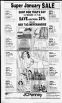
| OCR Text |
Show :;pMS COUNTY CUPPER, 08:048:0027, All of Lot 27, Somerset Farm, a planned unit Dev. Sec 12;T3N-R1W;SLCont .16 Acres. Total Tax $196.21 Harp Construction Co 08:048:0124, All of Lot 124! Somerset Farm, a planned unit Dev. Sec 12, T3N-R1SLM: Cont .16 Acres. Total Tax $1,123.26 L. Jay Findlay, 08:048:0125, All of Lot 125, Somerset Farm, A planned unit dev. Sec It, T3N-RISLM: Cont .16 Acres. Total Tax $196.21 Wayne C. Hickenlooper All of Lot 126! 08:048:0126, Somerset Farm, 'i s ! A planned unit dev. Sec 12, T3N-RISLM: Total Tax $712.88 Roger S. Webb, 08:048:0129. All of Lot 129, Somerset Farm, a planned unit Dev. Sec 12.T3N-R1W- ; SLM: Cont .16 ACRES. Total Tax $1,122 41 Timothy H. Behlo. 08:048 0136. All of Lot 126, Somerset Farm, a planned unit Dev. Sec 12 T3N-RISLM: Cont .16 Acres. Total Tax $196.21 Glade Wilkinson. 08:048:0153, All of Lot 153. Somerset Farm II (PUD) Sec 12; T3N-R1W- ; SLM: Total Tax $196.21 Blaine Harris. 08:048:0155. Pt of 144, Somerset Farm, planned unit dev. beg at a pt on N In ot Somerset st, sd pt being SW cor of Lot 144 & run th N 48 deg. 44'49" W 50.61 ft alg SW lot In as shown on original sub. Plat, to an aluminum cap; th 84 deg. 30' E 84 52 ft to an aluminum cap on N In of Somerset st: th 62.15 ft alg arc of a 259.18 ft rad curve to left to pob. Cont. .034 Acres. Total Tax $19 71 hory & Company. 08:0490061. All of Lot 61. Farmington Orchards No. Sec 12; T3N-R1SLM Cont. .34 Acres. Total Tax $179.07 hory & Company, 08:049 0068. All of Lot 68, Farmington Orchards No. Sec 12: T3N-RIW- : SLM Cont. .28 Acres Total Tax $170.50 Ivory & Company, 08:049 0072. All of Lot 72, Farmington Orchards No. Sec 12; T3N-RISLM Cont. .33 Acres. Total Tax $177.36 Ivory & Company, 08:049(8)73, All of Lot 73, Farmington Orchards No. I Sec 12; T3N-R1SLM Cont. .24 Acres. Total Tax $167.93 Ivory & Company, 08:049 0074, All of Lot 74, Farmington Orchards No. 1 Sec 12; T3N-R1SLM: Cont. .26 Acres. Total Tax $167.93 Ivory & Company, 08:049:0075, All of Lot 75, Farmington Orchards No. 1. Sec 12;T3N-R1W- ; SLM Cont. .24 Acres. Total Tax $165.36 Ivory & Company, 08:049:0076, All of Lot 76, Farmington Orchards No. 1 Sec 12; T3N-R1SLM Cont. .29 Acres. Total Tax $172.22 Ivory & Company, 08:049:0077, All of Lot 77, Farmington Orchards No. 1. Sec 12; T3N-R1SLM Cont. .37 Acres. Total Tax $183.36 Ivory & Company, 08:049:0078. All of Lot 78, Farmington Orchards No. 1 Sec 12; T3N-R1SLM Cont. .45 Acres. Total Tax $194.49 Ivory Company, 08:050:0001, All of Lot 1, Farmington Orchards No. I, Sec 12, T3N-R1SLM; cont. .24 Acres. Total Tax $165.36 Ivory Company, 08:050:0002, All of Lot 2, Farmington Orchards No. 1, Sec 12, T3N-R1SLM: Cont. .25 Acres. Total Tax $167.08 Ivory Company, 08:050:0003. All of Lot 3, Farmington Orchards No. 1, Sec 12, T3N-R1SLM: Cont. .27 Acres. Total Tax $170.50 Ivory Company. 08:050:0004, All of Lot 4, Farmington Orchards No. 1, Sec 12, T3N-R1SLM: Cont. .25 Acres. Total Tax $167.08 Ivory Company, 08:050:0005, All of Lot 5, Farmington Orchards No. 1, Sec 12, T3N-RISLM; cont. .25 Acres. Total Tax $167.08 Ivory Company, 08:050:0006, All of Lot 6, Farmington Orchards No. 1, Sec 12, T3N-R1SLM: cont. .25 Acres. Total Tax $167.08 Ivory Company, 08:050:0007. All of Lot 7, Farmington Orchards No. 1, Sec 12, T3N-RIW- ; SLM; Cont. .25 Acres. Total Tax $167.08 Ivory Company. 08:050:0008, All of Lot 8. Farmington Orchards No. 1 Sec I2,T3N-R1W;SLCont. .31 Acres. Total Tax $174.79 Ivory Company, 08:050:0009, All of Lot 9. Farmington Orchards No. 1. Sec 12. T3N-R1SLM; cont. .33 Acres. Total Taxes $177.36 Ivory Company, 08:050:0010, All of Lot 10. Farmington Orchards No. 1, Sec 12, SLM; cont. .26 Acres. $167.93 Total Tax Ivory Company. 08:050:0011. All T3N-R1- of Lot . Farmington Orchards No. 1. Sec 12. T3N-RISLM; Cont. .25 Acres. $167.08 Total Tax Ivory Company, 08:050:0012. All of Lot 12. Farmington Orchards No. I, Sec 12. T3N-RISLM: Cont. .25 Acres. $167.08 Total Tax Ivory Company, 08:050:0015. All of Lot 15, Farmington Orchards No. 1. Sec 12. T3N-RISLM Cont. .23 Acres. $169.65 Total Tax Ivory Company, 08:050:0016. All of Lot 16, Farmington Orchards No. I, Sec 12. T3N-R1SLM; Cont. .25 Acres. $167.08 Total Tax Ivory Company, 08:050:0017, All of Lot 17, Farmington Orchards No. 1, Sec 12. T3N-R1SLM: Cont. .25 Acres. $167.08 Total Tax Ivory Company, 08:050:0018, All of Lot 18, Farmington Orchards No. I, Sec 12. T3N-RISLM; Cont. .27 Acres. $169.65 Total Tax Ivory Company, 08:050:0019, All of Lot 19, Farmington Orchards No. 1, Sec 12, T3N-RISLM; cont. .27 Acres. ..$169.65 Total Tax Ivory Company, 08:050:0020, All of Lot 20, Farmington Orchards No. 1. Sec 12, SLM; cont. 23 Acres. T3N-R1- $163.65 Total Tax Ivory Company, 08:050:0021, All of Lot 2 I , Farmington Orchards No. 1, Sec 12, SLM; cont. .27 Acres. T3N-R1- Total Tax Gary L. $169.65 Spangenberg, 08:050:0022, All of Lot 22, Farmington Orchards No. 1, Sec 12.T3N-R1W- , SLM;cont. .32 Acres. Total Tax $176.50 DECFMREr 29, 1932 Hector Inc., 08:050:0024, All of Lot 24. Farmington Orchards No- 1, Sec 12, SLM: cont. .37 Acres. Total T3N-R1- Ta Ivory Company, $183.36 08:050:0026, All of Lot 26, Farmington Orchards No. 1, Sec 12, T3N-RISLM; Cont. .30 Acres. Total Tax $173.93 Ivory Company, 08:050:0035, All of Lot 35, Farmington Orchards No. ,Sec. 2, 1 T3N-R1- SLM; cont. .29 Acres. Total Tax $172.22 Ivory Company, 08:050:0039, All of Lot 39, Farmington Orchards No. 1, Sec 12, T3N-RISLM: cont. .26 Acres. Total Tax $167.93 Ivory Company, 08:050:0040, All of Lot 40, Farmington Orchards No. 1, Sec 12, SLM; T3N-R1- Cont. .23 Acres. Total Tax $163.65 Ivory Company, 08:050:0041, All of Lot 41, Farmington Orchards No. 1. Sec 12, T3N-R1- SLM; cont. .23 Acres. Total Tax $163.65 Ivory Company, 08:050:0042. All of Lot 42. Farmington Orchards No. 1, Sec 12, 13N-RISLM; cont. .23 Acres. Total Tax $163 6' Ivory Company. 08:050:0043. All of Lot 43, Farmington Orchards No. 1. Sec 12. 13N-RISLM; cont. .23 Acres. Total Tax $163.65 Ivory Company. 08:050:0044. All of Lot 44. Farmington 1. Orchards No. Sec 12. T3N-R1SLM; cont. .23 Acres. Total Tax $163.65 Ivory Company. 08:050:0045. All of Lot 45, Farmington Orchards No. 1. Sec W, SLM; .24 Acres. Ivory Company, 12 T3N-R- 1 Cont. Total Tax $165.36 08.050:0046. All of Lot 46, Farmington Orchards No. I. Sec 12. T3N-R1SLM; cont. .23 Acres. Total Tax 5163.65 Ivors Company. 08:050:04)47. All ol Lot 47, Farmington Sec 12, SLM; cont. .25 Orchards No. 1, T3N-RI- Acres. Total Tax $167.08 Ivory Company. 08.050:0048. All of Lot 48, Farmington Orchards No. 1, Sec 12, T3N-R1SLM: cont. .24 Acres. Total Tax $165.36 Ivory Company, 08.050.0049. All of Lot 49. Farmington Orchards No. I, Sec 12. T3N-R1SLM; cont. ,23 Acres. Total lax $163.65 Ivory Company, 08:050:0054. All of Lot 54, Farmington Orchards No. Sec 12; SLM Cont. T3N-R1- .27 Acres. Total Tax $169.65 Herman E. Wolfe, 08 052 0022. Beg 15.79 chs S fr NE cor of Sec 13; T3N-R- I W; SLM th W 176 ft: th S 123.75 ft; th E 176 ft: th N 123.75 ft to pob. cont. .50 Acres. Total Tax $513.22 Kent M. Callahan. 08:052:0054. Beg 9.6 chs N & N 88 deg. 15' F. 17.85 chs to W'ly In of rd & N 22 deg. 45' W 687.36 ft alg sdrd frcen sec I3;T3N-RIW;SLth N 22 deg. 45' W 123.5 ft alg sd rd; th S 85 deg. 28 W 191.08 ft; th W 185.65 ft; th S 22 deg. 45' E 19.64 ft; th N 88 deg. 15' E 377.8 ft to pob, cont 1.10 Acres. Total Tax $578.34 Peterson Inv. Co.. 08:052:0077, BegSOdeg. 50 W 2 10.67 ft alg the sc In fr th NE cor of Sec W; SLM: & th S 0 13; T3N-R- I deg. H50 W296.14ft;thS89 deg. 34'40W 205.63 ft; thS 29 deg. 2410 E 235.61 ft: thS 64 deg. 25 20" E 98.77 ft; th S 0 50 W 130.49 ft; th N deg. 89 deg. 4810 W 176 ft; th S 0 deg. 1150 W 155.20 ft; th N 89 deg. 14' W 388.10 ft alg a fen; th N 1 deg. 3355 W 989.38 ft alg an irreg fen; th N 83 deg. 51 '40 E 263.78 ft; thS 47 deg. 22 20" E 169.57 ft; th S 69 deg. 35'50 E 220.77 ft to pob. Cont 10.40 Acres. Total $558.63 Tax J. Jay Ferrin, 08:052:0101, Beg on S In of a str at a pt S 0 deg. 50 W 1384.54 ft alg sec Infr NE cor of Sec 13, T3N-R1SLM: & ninth SO deg. 11 50" W 146 ft alg sd sec In; th N 89 deg. 4810 W 101.875 ft; th N Odeg. H'50E 146 ft to sd Sin of sd str; S 89 degg. 48 10 E 101.875 ft alg sd S In to pob. Cont. .34 Ac. Out of Now or $121.67 0102. Total Tax Babco, 08:053:001 3, Beg at apt SO deg. 080.6 W 145.20 ft fr th W1. cor of Sec 13.T3N-R1W- ; SLM: th S 89 deg. 4252.9" E 160 ft: S 19 deg. 47'49" E 276.83 ft; th S 89 deg. 42'52.9" W 1 E 260 ft; th SO deg. 252.036 ft: thS 55 deg. 44.7 E 280 ft; th N 34 deg. 2915.3 E 73.914 ft: thS 89 deg. 3439.6 E 409. 10 ft; th SOdeg. 25'20.4 W 260 ft; th N 89 deg. 34'39.6 W 248.52 ft; S 0 deg. 25'20.4" W 100 ft; th N 89 deg. 34'39.6" W 260 ft alg th N In of sd lane to th E In of US Hwy91; th alg th Ely In of sd hy th folio 4 courses; N 55 deg. 30'44.7" W 777.384 ft: thN 53 deg. 42 8.6" W 63.127 ft: N 51 deg. 36 0.3" W 126.731 ft; th N 52 deg. 6'3.6 W 684.536 ft; th S 89 deg. 35'8.0"E 440.932 ft; thS 89 deg. 35' 8.6 E 207.135 ft; th ft to 5 0 deg. 08 0.6 W 0.5 pob. Cont. 14.75 acres. Total $816.74 Tax Anthony P. Hafen, 08:054:0005, 1 Com on E In of st hy . 1 chs S 6 S 70 deg. 30' W 8.3 chs fr the NEcorofSE'AofSec 13.T3N-R1W- ; SLM. th N 26 deg. O' W 128.15 ft alg E In of state hy: th N 70 deg. 30' E 104.1 ft to Win ofBERR deg. 8' E 127.8 ft; S 70 deg. 30 W 93.3 ft to beg. cont. .29 Acres. Total $127.66 Tax Marcus A. Olson, 08:054:0006. Beg 22.04 chs N & 4.90 chs W fr SE cor Sec 13; T3N-R1- SLM;thW6.125chs;thN4.50 chs, E to W In of hwy no. , SE alg sd WlnofHwy tobeg. Less 1 to BERR & Farmington 1.342 acres. Cont. in all 1.24 Acres. $642.60 Total Tax Loren H. Locher, 08:054:0010, line of hy 106 beg on E'ly R-at ptN Odeg. 5I'I4W 19.628 ft alg sec line & W 214.10 ft fr SE cor Sec 13; T3N-R1SLM: th N 22 deg. 26' 14" W 200.49 ft alg W'ly line of former th S 89 deg. BERR R-W 41 .5 ft alg S'ly line of 5 '30 Burke Lane (proposed) th S 27 deg. 08' E 64.37 ft alg sd st hy 106: th SEly alg sd st hy alg cur to left, the rad pt of which is N 62 deg. 52' E 595.6 ft a dist of 155.90 ft to pob. Cont .115 $9.42 Acres. Total Tax Loren H. Locher, 08:054:0020, R-In Beg at intersec of S'ly In of Burke Lane & E'ly R-of former Bamberger RR at a pt 21.04 chs N & approxly 235 ft PAGE NINE W fr SE cor of sd sec 13: T3N-R1SLM: th W 71.33 ft alg sd In of In ot Wly R-S'ly R-sd former Bamberger RR; th S 21 deg. 35' E 200.49 ft alg sd In of to NE'ly R-Wly R-state hyw 106 at a pt 40 ft rad 122 ft alg the arc of a 23,093.31 ft rad cur to the nght; (Note: tang to sd cur at its pob bears S 47 deg. 39 39" E); thN 418.92 ft to the pob. Cont. 1 .86 Acres. Out of FA 516X or 0007. Total Tax $72.83 dist NE'ly fr center In thereof; Oakridge Construction Co., th SEly 147.11 ft alg sd NEly 08:063:0022, Private Drive: R-6 In; wh is alg arc of a beg at th SW cor of Lot 14, ft rad cur, to sd E ly R-In; th Fairwav Fields Sub; Sec 14, N 21 deg. 35 W 71.47 ft alg sd T3N-RiSLM: th N 89 deg. R-In in sd an to angle pt E'ly 42 W 30 ft; thN Odeg. 18 3s 20 In; thE 82.8 ft mol to W'ly R-ft; th N 89 deg. 42 W 18ft; th N In of a Farm City road; th N 44 Odeg. 18 E 90 ft; th S 89 deg. W ft 197.7 mol to an deg. 30' 42 E 18 ft; th N 0 deg. 18 E R-E N In; th angle pt in sd ly 45.79 ft; th a pt on a 20 ft cur to 21 deg. W 76.60 ft to pob. 5' the left th alg sd cur 2 .06 ft to a Cont 5.07 Acres. Total pt on a 50.69 ft rad cur to th left; Tax $40.27 th alg sd cur 38.14 ft; th S 89 Del Roy Bangerter. 08 055:0009, .84 ft to a pt on a deg. 42 E All of Lot 9, Quail Cove (Pud). 50.69 ft rad cur to th right; th Amd alg sd cur 38. 14 ft to a pt on a 20 Cont. .283 Acres. Total ft rad cur to th left; th alg sd cur Tax $203.06 21.06 ft; th S 0 deg. 18 W Black sTitle Inc., 08:055:0023, All 155.79 ft to th pob. Cont. .123 of Lot 1, Quail Run; Sec-1$24.85 Acres. Total Tax T3N-R1SLM; cont. .340 Richard Scharp. 08:086:0001, All 1 Acs. Old Card 1 of Lot , Moon Park Sub. Sec Old Card SLM: Cont. 12; T3N-RITotal .255 Acres. Total Tax $651.17 Tax $213.34 Gordon Vanfleet. 08:087:0061, Black's Title Inc., 08:055:0024. All Beg .94 chs W fr N cor lot 1 , of Lot 2. Quail Run. Sec-1Blk 12 BC plat FarmTs. Sur.th .328 T3N.RIW; SLM; cont. E 30.39 ft mol to W In of Wal$21 1.63 Acs. Total Tax ker Ln at ptN 972.84 ft & 25.5 Blacks Title Inc. ,08:055:0025. All ft E fr S cor of Sec 24, T3N-R1of Lot 3, Quail Run; Sec 13; SLM: sd pt being also on T3N-RIW- ; SLM: cont. .377 th N ln of lot I sd blk 12; th N $220 20 Acres. Total Tax 80.16 ft alg W In of sd lane to All Black's Title Inc.. certain fence In; th W 50 ft alg of Lot 4. Quail Run, Set 13. sd fence ln; th S 16 ft; th W T3N-R1SLM: cont. .248 442.32 ft mol par to sd fence ln Total Tax $1.2I & 16 ft S there from to the Ely Black's Title Inc.. 08 055:0027. All th S ln of hy as desc in 401-2of Lot 5. Quail Run, Sec-140deg. 18 E 40 ft alg sd Ely ln; T3N.RIW, SLM: cont. .256 th Sly 351ft alg arc of 898.51ft Ac. Total Tax $197.06 rad cur to right algsd Elv In; th 5 14 deg. 45 48" E 114.91 ft Blacks Title Inc., 08:055:0028. All of Lot 6, Quail Run. Sec 13, mol alg sd Elv In to fence ln; th T3N-R1N 89 deg. 40:30" E 250.10 ft, SLM; Com. .249 Ac. Total Tax $196.21 mol, to W In of ppty desc bv 401-3Black's Title Inc. ,08:055:0029. All thN Odeg. II' W35.12 ft mol to SW cor of ppty desc of Lot 7. Quail Run, Sec 13, T3N-R1h SLM: Cont. .266 by NE'ly in a Ac. Total Tax $198.78 straight ln 75.39 ft mol alg the to a pt S of Black's Title Inc.. 08:055-0030All W'ly ln of 422-20- 2 of Lot 8, Quail Run, Sec 13, pob; th N 279.47 ft, mol, to T3N-R1SLM: Cont. .217 pob. subject to right of way Ac. Total Tax cont. 3.853 acres. Total $189.35 $263.89 Tax Black's Title Inc., 08:055:003 , All of Lot 9, Quail Run, Sec 13. Gordon Van Fleet. 08:087:0071, SLM: Cont. .225 ; Beg at a pi 386.92 ft N & W 19.88 ft &S 38 deg. 5648 W Ac. Total Tax $191.07 94.69 ft &N 41 deg. 3222" W Black's Title Inc., 08:055:0032. All 263.341 ft & N 34 deg. 30'39 of L,ot 10, Quail Run. Sec-1T3N-R1W 93.34 ft fr the SE cor of Sec SLM: cont. .234 W; SLM: & run th Ac. Total Tax $192.78 N 34 deg. 30' 39" W 194.49 ft; 1st Security Bank of Utah NA, N 24 deg. 4336" W 202.51 ft; 08:055:0034, All of lot 12, Quail T3N-R1SLM: Run; Sec-1N18deg.4530W 115.21 ft: E 161 .32 ft: S40 deg. 1809"E35 cont. .264 Ac. Total Tax ft; th SE'ly 351.41 ft alg the arc $198.78 1st Security Bank of Utah NA, of a i98.51 ft rad cur to the right; th S 14 deg. 35 45" E 08:055:0038, All of Lot 16, T3N-R1115.97 ft; W 133.19 ft to pob. Quail Run; Sec-1Cont. 1.944 ac. out of FA-58- 5 SLM: Cont. .292 Ac. Total Total or Tax $203.92 $133.66 Tax 1st Security Bank of Utah NA, 08:055:0039. All of Lot 17, Lawyers Title Ins. Corp., T3N-R108:088:0018, Beg at pt on W Quail Run; Sec-1R-line of st rd 106 N 0 deg. SLM: Cont. .290 Ac. Total 51' 14 W 1094.80 ft alg sec line Tax $203.92 1st Security Bank of Utah NA, 6 W 252.86 ft frSE cor Sec 13; T3N-R1SLM: th W 222.43 08:055:0040, All of Lot 18, T3N-R1ft; th S 134.69 ft: th N 89 deg. Quail Run; Sec-1SLM: Cont. .287 Ac. Total 44'07" E 184 ft ; th N 41 deg. 03 19" E 50.45 ft: th N 88 deg. Tax $203.06 23 19 El 13.64 ft to W'ly R-1st Security Bank of Utah NA, line of st rd 106; th NW'ly on a 08:055:0041, All of Lot 19. T3N-R1cur to right, the rad of w hich is Quail Run; Sec-1E 691.6 ft, a N 32 deg. 4832 SLM: Cont. .408 Ac. Total dist of 138.53 ft to pob, cont. Tax $227.05 .70 Acres. Total Tax $694.86 1st Security Bank of Utah NA. 08:055:0042, All of Lot 20, Cont. Bank & Trust--Eta- l. T3N-R108:088:0020, Beg on S In ppty Quail Run; Sec-113.51 chs N & conv in SLM: cont. .317 Ac. Total Tax $209.06 38.16chsN89deg.40' WofSE SLM. S 89 cor Sec 13, 3N-11st Security Bank of Utah NA, deg. 40 E 2406 ft. m or I, to W 08:055:0043, All of Lot 21. R3N-R1In of a 50 ft st, this being the Quail Run; Sec-1true pnt of beg. N 89 deg. 40' W SLM: Cont. .310 Ac. Total 130 ft, SOdeg. 20 W 1 10 ft, S Tax $208.20 89 deg. 40' E to pt on W In sd Hidden Quail Partnership, road, th NW'ly alg W ln sd road 08:055:0048, All of Lot 18, on 1697.3 ft radius curve to left Quail Cove (PUD) Amd Sec-1T3N-RIto beg, cont. .329 Acres. Total SLM: Cont. $677.73 Tax .472 Acres. Total Tax $239.05 Hidden Quail Partnership, Charles B. Clark, 08:088:0032. Beg on the N In of a 4 rod str & 08:055:0049, All of Lot 19; at the SW cor of Lot 2, Blk 15. Quail Cove (PUD) Amd Sec-1T3N-R1BC Plat, Farm TS Sur; sd pt of SLM: Cont. .586 Ac. Total Tax ... $261.32 beg is also N 0 deg. 3935" W 747.8 ft alg the A sec In & S 89 Hidden Quail Partnership, deg. 53 E 65.05 ft fr the center 08:055:0050, All of Lot 20. SLM: & of Sec 24.T3N-R1W- . Quail Cove (PUD) Amd Sec-13- ; T3N-R1run th S 89 deg. 53 E 312.5 ft SLM: Cont. .438 Acres. Out of alg the N In of sd str; th N 0 deg. 26 10 W 150 ft; th N 89 deg. Total or 53 W 40 ft; th N Odeg. 26I0" $293.03 Tax W 335 ft; th S 89 deg. 53 E Brokers Inc., Mortgage 248.9 ft; th N 0 deg. 26' 10" W 08:055:0054, All of Lot 15, In of 252 ft to the SWly R-Quail Cove (PUD) Amd Sec-1T3N-R1SLM: Cont. UPRR; th NWly 625. 18 ft alg sd SWly ln 50 ft dist SWly fr 1.082 Ac. Total Tax $3,311.53 center In of the track (long Inc., Mortgage Brokers chord bears N 41 deg. 15'40 08:055:0055. All of Lot 17, W 623.9 ft) th S 0 deg. 12 W Quail Cove (PUD) Amd Sec-1T3N-R11205 ft alg existing fence line to SLM: Cont. the pob. Cont. 7.293 Acres. .386 Ac. Total Tax . . . $222.77 $527.79 Total Tax Inc., Mortgage Brokers Samuel L. Lewis, 08:088:0034. 08:055:0056. All of Lot 1, Quail T3N-R1Cove (PUD) amd Sec-13- ; Beg at a pt on the N ln of a 4 rod st whi is S 89 deg. 53 E 42 1.4 ft SLM: Cont. .174 Acs. fr the SW cor of Lot 2, Blk 15, (Common Area). Total BC Plat, Farm Ts Sur; sd pt of $181.64 Tax beg is also N 0 deg. 39'35" W Inc., Mortgage Brokers 747.8 ft alg the ' sec In & S 89 08:055:0057, All ofLot2,Quail Cove (PUD) Amd Sec-1deg. 53' E 486.45 ft fr the cen of SLM: Run T3N-R1Sec 24; T3N-R1SLM: Cont. .233 thN Odeg. 26 10 W 400 ft; th Acs. (Common Area). Total N 89 deg. 53 W 108.9 ft :th SO $192.78 Tax deg. 26' 10 E 400 ft; th S 89 Inc., Mortgage Brokers deg. 53 E 108.9 ft to the pob. 08:055:0058, All of Lot 3, Quail Cont. 1.00 Acres. Total Cove (PUD). Amd Sec-1T3N-R1$775.28 Tax SLM: Cont. .451 $235.62 Richard K. Robinsvn. Acres. Total Tax 08:089:0028. Beg at SE cor Blk DonR. Boyce. 08:057:0019, Begat ft ft 1215.72 427.68 Efr S& 7,PlatA.FarmTs.N 125 ft. W apt 70 ft, S 125.0 ft, E 70 ft, m or I. NW cor of sd sec 14, T3N-R- 1 to beg. Cont. .20 Acres. Total W; SLM th S 330 ft alg E In $433.54 Tax of lot 4 of James T Workman Darrold W. Schryver. Survey th W 132 ft mol alg S In In of 08:089:0034, Beg at apt 177.5 ft of sd sur to N'ly R-W & 96 ft N of SE cor of Lot 2. Shephard Ln overpass rd at a Blk 7, Plat A, Farm TS Sur; th pt 90 ft rad dist NEly fr cen ln W 78 ft mol to E In of hwy ; th N of sd overpass rd approx at EnOdeg. 4730"E 104.02 ft algsd gineer station 30 plus 17 th hyw; th E 75.24 ft to a pt due N SE'ly 15 ft, mol alg arc of a of the pob; th S 104 ft to pob. 482.96 ft rad cur to left (Note: Cont .19 Acres subject to R-Tang to sd cur at it pob bears ' $709.43 Total Tax approx S 64 deg. 2 1 E) th S 58 5. deg. 00'38E 88.21 fttoapt70 ft rad dist NEly fr sd cen ln engineer station 29 00 th Ely ft 359.93 ft alg arc of a 502. rad cur to left to a pt 70 ft rad dist NWly fr sd cen ln at engineer station 24 plus 89.98 (Note: tang to sd cur at its pob bears S 76 deg. 0353 E) th N 62 deg. 56 E 77 ft mol alg sd Nly R-- In par to sd cen In to ln of Union Pacific SWly R-RR th NW'ly 490 ft mol alg sd In to pob cont. 2. W SWly R-or Acres. Out of Total now $82.25 Tax Steven L. Nielsen, 08:057:0021, Being in the NEVi NE of Sec SLM: beg at a 14, T3N-R1pt 458.93 ftS&45.54ftWfr the N ' cor of Sec 14; Th SWly alg of relocated the S'ly Shephard Lane the folio: two courses S 75 deg. 23'29" W 322 Richard Robinson. K. 08:089:0037, Beg 70 ft W fr SE cor Blk 7, Plat A" Farming-toTS. Sur; which pt is also 1 19.5 ft W & 49.5 ft N of cen line of state st & 3rd West st; th N 125.0 ft th E 70 ft; th N 370 ft; thW 301.0 ft; th S 226.35 ft; th E 88.15 ft; th S 104.5 ft: th E 87.4 ft; th S 163.5 ft; thE 58.0 ft to pob, cont 2.33 Acres. Total $299.88 Tax James Dean Moon, 08:094:0005. All of Lot 5 Shepard Creek Country Est. PUD, Sec T3N-R1SLM out of FA- 12 531. Total Tax $388.13 James Dean Moon, 08:094:0006. All of Lot 6 Sheppard Creek Country Est PUD Sec 12 out Tot- ofFA-53- $388.13 al Tax R-- ft; th S 54 deg. 5751W 80.43 ft to th E NEly no access ln of a freeway known as Proj No. th SE'ly alg sd In the follow: two courese; S 53 deg. 47 E 354.14 ft; th SElv FRUIT HEIGHTS ABH Barton Bros Inv. Corp., 07:080:-000Beg at NW Cor of SE 14 of NW 14 of Sec 1;T3N-R1W- ; SLM: Thence East 700 feet, thence South 15 oegs. 30' East 24.53 feet M or L to projected Nly line of Barton Manor No. 3 sub; th South 88 degs. 14' W 706.89 ft alg said N'ly line to a pt S 45.43 ft from the POB. Thence North 45.43 ft to beg; Cont. 5'8 Acre. Total Tax $158.23 Barton Bros Inv. Corp., 07:080.-009Beg at SW cor of SE 4 of NW 14 of Sec 1; T3N-RlSLM: Thence N 47 degs 02 E 276.06 ft M or L to the most S ly cor of Lot 3P Barton Manor No. 3 sub: th N 43 degs. 21 25" West 2'8 09 ft along the SWly line of said sub. th S 66 degs W 12 14 ft M or L to th W line of said SE I 4 of NW I 4 th S along sd line 385.41 ft M or L to POB. Cont. 93 Ac. Total Tax $180 82 Lynn Karl Porter. 07:080 0005. Beg 300 ft W fr NE Cor of SF 4 of NW 1 4 of Sec 1; 7:N-RW- . Th South 42 degs. $$ 85 ft; thence South 13 digs. 20' W 85 feet; thence S '4 degs. 20' W 63.1 feet; th E 109 22 ft; thence N 3 degs. 06 09" W 184.09 ft. thence N 88 12 L 41" 11.75 degs It. thence N 4 degs. 20' E H 87 ft to th POB Cont. .25 Lres. lotal Tax $26 05 Lynn Karl Porter. 07:080 0007. Beg 115 feet West from NE I or of SE 4 of NW I 4 Sec T3N-R1SLM. Th W '4 86 ft; thence S 4 degs. 20' West 12.39 ft: th S '88 degs. 12 41" W 12 ft; th S 3 decs. 06 09" E 92 43 ft. th E 12' 81 ft: th N .I4 ft, M or L. th N 88 degs. 12' 41" E Util ft; th N 8.36 ft th N 3 36 ft to th POB. Cont. .31 Acres. Together with a desc. r w lotal Tax $114.93 Barmn Bros Inv. Corp . 07 080:-002Beg N 89 degs 46' W' 4' 5 ft fr NW cor of Lot 16. Barton Manor No. I. amendSLM: ed, sec I; T3N-R1lit S 89 degs. 46' E 45.59 ft, M or L, to NL cor of sd Lot 16. thence N 2 degs 50 03" F. 88 99 ft to cen line of Cieek; th W 57.9 ft, M or I, to L In of hy; th South 3 degs. 39' E to POB. Cont. .083 Acres. Total Tax $4.60 Latry 2"" W. Pulsipher, 07:080:-0027- . Beg at a pt S 81 degs. 10" W 106.46 ft fr the NE cor of Lot 9. Green Mts. est. sub Sec I. T3N-RISLM: A suh of part of the NW L4 of Sec and run th S 81 degs 27' 10" W 45 ft M or L to the E'ly line of A street; thence SE'ly 27 ft M or La along the arc of a 1(H) ft rad cur to the right to a pt S 48 degs. 08 07" W of the POB. Ih N 48 degs. 08' 07" E 34.14 ft ft to the POB. Cont. .010 Acres. Total T ax $3.83 07:080:- Janies H. Hammons. 0031, Beg at a pt 198 ft South and 563.56 ft W of th NE cor of th SE 14 of th NW F4 of Sec I; T3N-R1SLM: Th S 15 degs. 30 E 103.77 ft; th Last 149.57 ft; th N 15 degs. 30' W 103.77 ft; M or L th W 149.57 ft to th POB. Cont. 34 Acres reserving water rights Total Tax $36.01 Environs, 07:080.0039, Beg at a pt common to W r'w In of hwy 89 and S In of Rd at a pt N 89 degs. 59 50" E 688.96 ft along sec In and S 0 deg. 00 10" E 1440.22 ft fr NW cor of Sec 1, T3N-R1SLM; Th S 3 degs. 54 30" E 186 ft along W ln of sd hvw th S 64 degs. 16 W 147.42 ft th N 3 degs 54 30 W 225.18 ft th N 79 degs. 34 30" E 137.75 ft along S ln of Ed to POB Cont. .65 Acres. tal Tax $150.94 Brian T. Stewart, 07:080:0063, S line of a road at Beg on th a pt 263.50 ft West and South 3 degs. 06 09" E 12.72 ft fr th NE cor of th SE 14 of th NW 14 of Sec 1; T3N-RISLM: Th S 88 degs. 12 41W 50.02 ft; th S 3 degs. 6 09" E 184.09 ft; th E 191.85 E ft; th N 11 degs. 20 42 34.68 ft; th W 27.82 ft; th N 59 ft; th W 125 81 ft; th N 3 degs. 6 09" W 92.43 ft, M or L, to th S ln of said road and the POB. Cont. .50 Acres subj to rw desc in Total Tax $52.87 Arles K. Steiner. 07:080:0076, Beg at a pt 12 ft S fr NE cor of SE 14 of NW 14 of Sec I; T3N-R1SLM: Th N 12 ft th W 115 ft: th S 8.36 ft th S 88 degs. 12 41" W 17.01 ft; th S 155.14 ft thE 27.82 ft th N 11 degs. 20 42 E 49.90 ft to NE cor of ppty conv in 370-29- 3 th E along N ln of said ppty 141.5 ft M or L to Wly line of hwy th Nly along said W In 105.25 ft M or L to pt due E of POB th W 57 ft to POB Cont .51 Ac .02 ac bal cont less to 831-12- 4 .49 acre. Total Tax $592.27 James Herbert Hammons, Beg at a pt 198 ft S and 290 ft W of the NE Cor of the SE 14 of the NW 1,4 SLM: of Sec 1; T3N-RIW- ; and run th W 123.99 ft, M or L, th South 15 degs. E 103.77 ft, M or L, to the S In of Grantor's ppty. th E 75.76 ft. M or L, th N 15 degs. E 103.77 ft, M or L, to the POB. Cont. .23 Acres. Total Tax $16.09 Environs Corporation. 07:082:- 0032, Beg at a pt S 0 deg. 02 53 E 09 ft alg the L4 sec ln and S 89 degs. 57 07" W 1154.74 ft to the Ely In of a hy; and S 54 degs. 14' 30" E 367 ft; and South 35 degs. 45 30 W 591.29 ft; thence N 78 degs. 57' W 296.48 ft and South 40 degs. 15 E 176.13 ft and N 72 degs. 12 E 444 ft and South 87 degs. 12 E 241.80 ft; and South 47 .40 ft fr the cen degs. 26 E of Sec I, T3N-R1SLM: Run th S 47 degs. 26 E 140 fit; th S 75 degs. 08 E 83 ft; th N 64 degs. 11 E 183.90 ft; th N 26 degs. 40 E 1x5 ft; th S 45 degs 18' 33" W 149.07 ft; th S 79 degs. W 152 ft; th N 65 degs. 15' W 160 ft to the POB. Cont. .32 Acres. Total Tax $3.83 Environs Corporation, 07:082:- 0033, Beg at a pt S 0 deg. 02 53" E 869.09 ft along th 14 Sec ln and S 89 degs. 57 07 W 1154.74 ft to the Ely ln of a hy and S 54 degs. 14' 30" E 367 ft and South 35 degs, 45 30 W 591.29 ft cr the cen 8. SLM: of Sec 1. T3N-R1and run th N 78 degs. 57 W 48 ft; th S 40 degs 15 E 176 13 ft ft; th North 72 degs. 12 E 228.23 ft: th N 78 degs. 57 W 40 88 ft to the POB. Cont. .43 Acres. $45.21 Total Tax Ben F. Holbrook, 07:084:0015, All of Lot 15. amended. T3N-R1SLM: Barton Manor No. 1, Cont. ,475 Acres Total Tax $1,004 49 Barton Bros Inv. COrp., 07:086:-031All of Lot 319 Barton Manor No. 3, Sec 1; T3N-RISLM: Cont .23 Acres. $122 59 Total Tax Richard V. Clay, 07:087-0015All of Lot 15, Green Mountain Estates Sec 1; T3N-R1SLM: Cont. .292 Acres. $146.34 Total Tax 07 088:-000Duane L. Meacham, All of Lot 1, Green ; Oaks Est. Sec 1; SLM: Cont. .24 Acres. $489.54 Total Tax L. Dale Green. 07:088:-0004- , All of Lot 4, Green Oaks Est. Sec 1: T3N-R1SLM. Cont. .29 Acres. $127.19 Total Tax David N. Phelps. 07:0890009, Lot 9. Tamara Estates Sub SLM: ; amd Sec 1, Cont. .52 Acres. $692.64 Total Tax David N. Phelps. 07:089:0010. Lot 10 Tamara Estates Sub amd Sec I. T3N-R1SLM: Cont. .252 Acres. Total Tax $122.59 Stephen W. Lindsey, 07:090:-001Lot 17, Park View Est. No. 1. Sec 1. T3N-RISSM: Cont. .28 Acres. Total Tax $1,048.93 Greg L. Winget, 07:090:0050. All of Lot 50. Parkview Estates No. 4, Sec 1. T3N-R1SLM: Cont. .45 Acres. Total Tax $648.97 Aztec Const, and Insulation Etal. 07:090:0060, All of Lot 60, Parkview Estates No. 4. T3N-RIW- ; 1. Sec SLM: Cont. .23 Acres. Total Tax $122.59 Donald H. Fraser. 07 092:0012. All of Lot 12, East Oaks Plat ; B, Sec 1, SLM: Cont. .49 Acres. Total Tax $1.409 81 07:092 0024, Dana Hales, All of Lot 24, Fast Oaks Plat '; SLM: B, Sec I Cont, ,613 Acres. Total Tax $2,144.38 Dean L. Carlston. 07:092:0033, All of Lot 33, East Oaks Plat SLM: C, Sec 1, T3N-R1Cont. .36 Acres. Total Tax $147.11 W'llliam A. Johnson. 07:093: 0008, Apt 8, Unit B, Somerset Place Cond. Sec 1; T3N-R1SLM: Total Tax $445.93 Mont Rosenberg, 07:101:0024. All of Lot 24, Creek View Est. Sec 2; T3N-R1SLM: Cont .28 Acres. Total Tax $117.23 07:101:-002Ivory and Company. All of Lot 29. Creek View Est. Sec 2; T3N-R1SLM: Cont. .28 Acres. Total Tax $117.23 Arjen W. Jager. 07:101:0034, All of Lot 34. Creek View Est. Sec 2; T3N-RISLM: Cont. .28 Acres. Total Tax $648.21 2. Ivory and Company, 07:101:-003All of Lot 38, Creek ; View Est. II Sec 2; SLM: Cont. .29 Acres. T3N-R1W- Total Tax $117.99 Ivory and Company, 07:101:-003All of Lot 39, Creek View Est. II Sec 2; T3N-R1SLM: Cont. .28 Acres. Total Tax $117.23 Ivory and Company, 07:101:-004All of Lot 40, Creek View Est. II Sec 2; T3N-R1SLM: Cont. .28 Acres. Total Tax $117.23 Ivory and Company. 07:101:-0041- ; All of Lot 41, Creek View Est. II Sec 2; T3N-R1SLM: Cont. .28 Acres. Total Tax $117.23 Ivory and Company, 07:101:-0042- ; All of Lot 42, Creek View Est. II Sec 2; T3N-R1SLM: Cont. .28 Acres. Total Tax $117.23 Ivory and Company, 07:101:-0043- ; All of Lot 43. Creek '; View Est. II Sec 2; SLM: Cont. .28 Acres. T3N-R1W- Total Tax $117.23 Ivory and Company, 07:101:-0044- ; All of Lot 44, Creek View Est. II Sec 2; T3N-R1SLM: Cont. .28 Acres. Total Tax $117.23 Ivory and Company, 07:101:-0046- ; All of Lot 46, Creek View Est. II Sec 2; T3N-R1SLM: Cont. .51 Acres. Total Tax $140.98 Ivory and Company, 07:101:-004All of Lot 47, Creek View Est. II Sec 2; T3N-RISLM: Cont. .35 Acres. Total Tax $124.12 Ivory and Company, 07:101:-0049- ; All of Lot 49. Creek View Est. II Sec 2; T3N-R1SLM: Cont. .39 Acres. Total Tax $128.72 Hayes Inc.. 07:101:0059, All of Lot 59, Creek View Est. W; SLM: II, Sec 2T3N-R1 Cont. .28 Acres. Total Tax $455.12 Ivory and Company, 07:101:-0060- ; All of Lot 60, Creek View Est. 11 Sec 2; T3N-R1SLM; Cont. .28 Acres. Total Tax $117.23 Ivory and Company, 07:101:-006All of Lot 61, Creek View Est. II Sec 2; T3N-R1SLM: Cont. .28 Acres. Total Tax $117.23 Ivory and Company, 07:101:-006All of Lot 63, Creek View Est. II Sec 2; T3N-R1SLM: Cont. .28 Acres. Total Tax $117.23 Ivory and Company, 07:101:-006All of Lot 64. Creek View Est. II Sec 2; T3N-R1SLM: Cont. .28 Acres. Total Tax $117.23 Ivory and Company, 07:101:-006All of Lot 65, Creek View Est. II Sec 2; T3N-R1SLM: Cont. .28 Acres. Total Tax $117.23 Roland F. Clift, 07:101:0066 All of Lot 66, Creek View Est. II, Sec 2T3N-RW; 1 SLM: Cont. .33 Acres. Total Tax.... $878.83 & Company, 07:101:0067, All of Lot 67. Creek View Est. SLM: II, Sec 2 Cont. .31 Acres. Total Taxes $120.29 Ivory T3N-R1- Ivory and Company, 07:101:-0071- ; All of Lot 71, Creek View Est. II Sec 2; T3N-R1SLM: Cont. .28 Acres. Total Tax $117.23 Ivory, and Company, 07:101:-0072- ; All of Lot 72. Creek View Est. II Sec 2. T3N-R1W- ; SLM: Cont. .28 Acres $117.23 Total Tax Ivory and Company, 07:101:-0074- ; All of Lot 74, Creek View Est. II Sec 2; T3N-R1- SLM: Cont. .28 Acres. $117.23 Total Tax Ivorv and Company. 07.101:-007All of Lot 75. Creek View Est. II Sec 2; T3N-RISLM. Cont. ,31 Acres Total Tax $120.29 Isory and Companv. 07 Kory and Company. 07 101 0078; All of Lot 78. Creek View Est. II Sec 2; T3N-R1SLM: Cont. .28 Acres. $117.23 Total Tax Kory and Company. O'1 All of Lot 80. Creek View Est. II Sec 2: T3N-R1- SLM: Cont Total Tax .32 Acres. $121 06 Company. O'1 101 Kory and 0083; Beg at SL cor of said Lot 7 Creek View F.st Sec 2. T3N-R1SLM th South 89 degs. 5L 07" W 100 ft th N 0, ft to a deg. 08' 53" W 6 fence thence South 89 deg 16' 51" Li 100 ft along vud fence th S 0 deg 08' 53" L 4.6 ft to POB Cont Acre. Total Tax 01 $3 83 Ivory and Company, 07.101:-0084- : Part of Lot 3. 4. 5. of Creek View Esi No. I Sec 2 T3N-RIW- ; SLM A part of said lots lying South offence In located as follows. Beg 7.6 ft. N of SE Cor of said Lot 5 th N 89 degs. 16' 51" W 3Kt ft to a pt 12.1 ft N of SW cor of said L.ot 3 Cont .07 Acres $6 90 Total Tax Kory and Company, 07 101 0089. Part of Lot 6. Creek Ests: Beg at the SF cor of said Lot 6. and run th N 0 deg. 8' 53" W 6 ft: th N 89 degs. 16' 51" W HR) ft along a fence In; thence S 0 deg. 8' 53" W 7.6 ft to the SW Cor of said Lot; thence N 89 degs. 51 07" L IIKI ft to the View POB. Cont. .016 Acres remaining of $3 83 Total Tax William C. Gayler. 07:107 0015, All of Lot 15, Park Heights. : Plat B. Sec 35; T4N-RISLM. Cont. .302 Acres. $525 61 Total Tax Faerber Const. Co.. 1:1 !6 (KK6. Beg at pt N 0 deg. 08' W 186.75 ft and North 43 degs. 33' West 402.6 ft and S "0 degs. 13' W 890 6 ft and N 20 degs. W 16.5 feet and N 89 degs. 52' W 295.36 ft and N 89 degs. 23' W 328 M) ft fi : SE Cor of Sec 35; SLM: Said pt being the SW Cor of the Orchards Unit No. sub; th N 36 degs. 22' 33' W'est 619.19 ft along the W 'ly In sd sub; thence S 26 degs. IF 44' East 558 35 ft to cen ln of a rd; th S 89 degs. 52' F. 120.75 ft along said cen In to POB Cont. .69 Acres. $72.79 Total Tax James C. Kaiserman. 11:116 0009, Beg on th S'ly In of Grand Oaks Sub Plat "B" at a pt S 0 degs. 10 30" W 1533.85 ft and E 347.01 ft and N 87 degs. 44' 39" E 609.20 E ft and N 87 degs. 38' 54 248.80 ft fr thence center of ; Sec 35, Thence North T4N-R1W- 87 SLM: degs. 38' 54" E 106.11 ft: thence S II degs. 28' East 265.47 ft to a pt on a fen ln: thence S 77 degs. 10' 25" W' 109.23 ft to th SE Cor of Peach Tree Sub: thence N 8 degs. 30' W 167.13 feet: thence S 81 degs. 30 West 10.32 ft. thence N 8 degs. 30' thence W S 81 10.32 ft thence W' 167.13 feet ; degs. 30' W N 8 degs. 30' 117.6 feet to th POB. Cont. .67 Acres. $35.25 Total Tax Florence Anne Barnes. 11.116:-001Part of Blks 9 and 10, Plat E, Kays. Beg at SW Cor of Lot 13. Countrv Place No. : SLM: I, Sec 36. Run th S 69 degs 50' 48" W 349.43 ft; th S 72 degs. 37' 47" W 87.68 ft to SE Cor of Lot 16, sd subd; th N 20 degs W 306.41 ft to S line of a st: thence E'ly 446.93 ft along S line of said st to NW cor of Lot 13. sd sub: thence South 19 degs. 27' East 260.91 feet to POB. Cont. 2.73 Acres. Total Tax $173.26 Gordon Thurman W'ard, 11:117:-001Beg Souh 89 degrees 54' E 422.9 ft andd S 3 degs 39' E 793.5 feet and N 85 degs. 21' E 25.0 ft fr NW Cor Sec 36: T4N-R1SLM. Th S 3 degs. 39 East 225.21 ft along E line of ppty conv to st rd in 402-46th N 85 degs. 21' E 821.9 ft to E In of grantors land; th N 225.21 ft M or L to a pt N 85 degs. 21 E of beg; thence S 85 degs. 21 W 821.9 ft M or L to POB. Cont. 4.088 Acres Total Tax $(57.05 James H. Brough, 11:117:0041, Beg at SE cor of Lot 9. Mtn. Terrace Est., at a pt South 89 degs. 39 E 617.02 ft along sec ln and South 356 20 ft and N 69 degs. 33 East 1162.92 ft from W 14 comer of Sec 36, T4N-R1SLM: and run thence N 43 degs. 09 23 West 228.87 feet: thence N 61 degs. 39' 30 ' West 17.28 feet; thence N 22 degs. 56 32 East 118.37 ft; thence N 67 degs. 03 28" W 4 0 ft; thence N 22 degs. 56' 32" E 60 ft: th NW'ly 47.51 ft aaong NEly line of a str along aac of a 260 ft rad cur to left; thence N 12 degs. 28' 23 East 166.84 ft; thence N 69 degs. 58' 21 East 725.0 feet; thence South 24 degs. 20' East 65.74 feet; thence North 70 degs. East 353.1 ft. to 14 sec ln; th S 0 deg. 07' 10 E 482.16 ft along 4 sec In; thence S 69 degs. 33' W 988.26 ft to POB Cont. 12.72 Ac. (Was Total Tax $668.89 Alden Burton, 11:1 19 0029, Beg 9.9 ft East and N 25 degs. v W 1789.10 ft and N 34 degs 27 W 324.05 ft. fr S F4 cor T4N-R1Sec of 36, SLM: Th S 71 degs. 23' W 358.05 ft; thence S 25 degs. 56 E 316.57 ft; thence North 70 degs. East 375 ft, M or L, to Wly line of Old Mtn Rd: Th NWly along said road. 285 ft, M or La, to POB. Cont. 2.46 Acres. Total Tax $615.26 1 I 101:-007- All of Lot' 76. Creek View Est. 11 Sec 2; T3N-R1W- ; SLM: Cont. .28 Acres. $117.23 Total Tax Ivory and Company. 07 101 0077; All of Lot 77. Creek View Est. 11 Sec 2; T3N-RIW- ; SLM: Cont. .31 Acres. $120.29 Total Tax David L. Cook. 11.119 0039, Beg in cen of County Rd at pt N 25 degs. 40' West 631.5 ft and South 65 degs. 44 West 4 comer sec 2 59 feet fr S SLM Thence ; 36. S 65 degs 44 West 464 41 ft: thence N 30 degs. West 136 09 ft. thence N 65 degs. 40' Last 477.85 feet to cen sd road; thence S 26 degs 33' Last 136.06 ft along said road 50 Acres. to POB. Cont $911.78 Total Tax Alden Burton. II II9 (Kt46. Beg at a pt 9 9 tt L and N 25 degs. 55' W 1789 I ft to a pt on E In of a road and N 7 degs 02' 22" Last '22 94 ft fr S 4 cor of Sec 36- 14V Run Th N 31 R1W . SLM degs 25' W 313 42 ft. thence N degs 34' E 464 '() ft M 4 of or L to F In of SW said Sec 36. thence S 316 5 ft 4 Sec In to a M or L along pt N "I degs 02' 22" E ot pt of Beg. th S "I degs 02 22" W 2v4 2 ft M or I to PUB Cont 2 62" together with r w. $16.09 To'al lax Alden Burton, li 110 004". Beg tt N Ir SL cor ot SW 186' ! 4 ot Sec 36. 4 V IW. SI M. -3 N 331 3 ft. N Jtgs 43' L I'l ' t(. s 24 degs I' L 31' ft S '0 degs 2 '09 to beg f ont I '4 Avies ' $16 09 lota! lav Alden Burton. II 119 0069 Beg 9 9 tt .ot und N 25 degs 5'' W I4'3 ft and N '() degs 3S F 4'9 2 ft and N 19 degs 4 vor of 22' W '6 ft tr S . Si M Th Sec 36, 19 degs 22' W 2'3 88 ft. N thence N '1 degs 02 22 L ast 101 98 tt. M or L to Scv 1 n. thence S 266 84 teet. W 18' 0 dees thence S Cont 212 62 feet to POB or 1499 .L w.,c JH ' lo'ulTuv $ 1 "9 (Rfi). Beg. 1604 36 ft N tr SL C or ot SW 4 of Sec 36. 4N. IW . SI M N 293 14 tt. N 0 degs Last 3(19 ft. S 24 degs II''. L 248 '9 tt. South '0 degs 38 W 413 4 Ft to Beg Cont 2 o3 Acres $2145 lotal lax 121 (KKU. Grunt L Barhen. All ot Lot 1. Mtn Terr , ice Alden Burton. II 19 Se c -36 T4N 1st SIM Cont .28 Ac. - . R W . 1 otal Tax $'4 32 James H. Brough. II 121 0002. All of Lot 2. Mtn Terrace 1st. Sec-36- . : 14N-RIW- SLM Cont. 28 Ac Total Tax $'4 32 Janies H. Brough. 11 121 (KKU, AH of Lot 3. Mtn I errace Est. SI Sec-36- M . Cont R N I Total! u James All $- Btough. II Lot 4. Mtn H ot 1st. Sec-26- I W : 28 Ac . SLM Com 2 -4 32 (KKI4. I errace J4N-R1- 29 Ac Total! ax $'5 09 Brough. 11.121000'. All of Lot 5. Mtn Terrace T4N-RIW- . Sec-26- . F st ; SLM Cont. 30 AcTotal Tax $'6.62 Janies H Brough. II 121 0006. All of l.ot 6. Mtn Terrace T4N-R1W- ; Sec-36- . F.st STM Corn 28 Ac. Total Tax $'4 32 James H Brough. 11.121 0007. All of Lot 7. Mtn Terrace : F.st: Sec-36- . SLM. Cont. .28 Ac. Total Tax $4 32 James H Brough. II 121 0008, All of l.ot 8. Mtn Terrace James F H s t Se c -3 . 6 T 4 N - R W , unt 28 Ac. Total Tax $74.32 James H. Brough, 11:121.0011, All of Lot II. Mtn Terrace SL.M Est, ( Sec-y- . T4N-R1W- ; SLM Cont. .29 Ac. Total Tax $75.09 James H. Brough. 11.1210012. All of Lot 12. Mtn Terrace Est. Sec-36- . T4N-R1- SLM. Cont. .29 Ac. Total Tax $75 09 James H. Brough. 11:1210013. All ol Lot 13. Mtn Terrace Est. Sec-36- . T4N-R1- SLM. Cont. .28 Ac. Total Tax $74.32 James H. Brough. 11.121.0014. All of Lot 14. Mtn Terrace Est. Sec-36- . T4N-R1- SLM. Cont. 28 Ac. Total Tax $'4.32 James H. Brough. II 121.0015. All of Lot 15. Mtn Terrace Est. Sec-36- . T4N-R1W- : SLM Cont. .28 Ac Total Tax $74 32 12 1 0016, James H. Brough. All of Lot 16. Mtn Terrace Est. Sec-36- . T4N-R1- SLM Cont. .28 Ac. Total Tax $74.32 James H. Brough. 11121 (K)17, All of Lot 17. Mtn Terrace Est: Sec-36- . T4N-R1- SLM Cont .28 Ac Total Tax James H Brough. II All of Lot 18. Mtn Est: Sec-36- . $'4.32 0018. Terrace 121 T4N-R1- SLM. Com. .28 Ac. Total Tax $'4 32 James H Brough. 11 2 00 19. All of l.ot 9. Mm Terrace Est; Sec-36- . I4N-R1W- ; SLM Corn 32 Ac Total Tax $'8 15 Brandon A Brunson. 11 All of Lot 3. Carrie His Sec 36: T4N-R1SLM' Cont. .2'.' Acres Total Tax $48 58 11.124:-(HKtD. Clayton Fairhoum. Lot 8. Rufv Acres Sub. Sec. 36. TP4N. RGIW. SLM, Cont 453 Acres. Total Tax $721.76 Cook Lumber Inc.. 11 143 0045, All of Lot 45. Grand Oaks Plat A. Sec 3S T4N-R1SLM. Com .259 Acres. Total Tax S651.27 James Wnght. 11.143.0052. of Lot 52. Grand Oaks Plat A. Sec 35: T4N-R1SLM Cont .30 Acres. Excepting: Beg at the NE Cor of said Lot 52. said subd; and run thence S 88 degs. 19 94 ft; thence S 22 West degs. 48 E 129.69 ft; thence N 88 degs. 20 09" E 1.94 ft to the SE cor of said lot; thence North 22 degs. 48 W 129.69 ft to the POB. Cont. .005 Ac. Total 0.295 Acres. Total Tax $1,280.32 Golden West Dev. Int., 1L143--0067- . All of Ely 1.81 ft of Lot 1. Grand Oaks Plat A. Sec 3o; T4N-R1SLM: Cont. .005 Acres. Total Tax $3.83 Floyd B. Parkin. 11:143:0068, Beg at th NE Cor of Lot 2, Grand Oaks; Plat A" Sec 35; T4N-R1SLM Th South 53 degs. 47 39 W 1.51 ft; thence South 40 degs. 57 21" East 35.36 ft: th W All (Continued) |