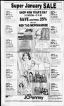
| OCR Text |
Show DAVIS COUNTY CLIPPER, DECEMBER 29, 1982 168 84 feet to a pt on E In of Oakleaf Sub plat D, thence i?iUtA4(ldegs- 58 56" 223.659 feet to thence POB. nl284 Acres less thence foil: Beg at thence most E'lv comer of Lot 17; Oakleaf Sub Plat D, thence South 40 degs. 58 56 West along said lot line 127.73 feet, M or L. to th S In of ppty owned bv Arnell E. Heaps; thence 146.68 feet; thence North to a pt South 56 degs. 42' East of thence POB; Thence N 56 degs. 48 W 75 feet, M or L, to thence POB. Corn. .22 Acres Total. 064 Acres Total Tax 512 02 S. Arthur Gregersen. 01:048 - 0058. Also beg N 0 deg. 26' W 1322.7 feet and South 80 degs. 53 28 degs W 1320 5 feet, North 32 25 feet. North 89 degs. 47 West 187 42 ft from SE Cor SEC 1, TIN- RIW, SLM: North 89 degs. 47 W 307.58 feet. South 16 West 2580 feet. degs. 47 South 89 degs 47 East 30 ft. North 16 degs. 47 East 8 6 feet. South 89 degs. 47 East 282.5 feet, thence North 16 5 feet to Beg, Corn. .13 Acre. Total Tax $12 02 Michael W. Eraser. 01:077:0006, All of Lot 6, Oakleaf Sub Plat "C" Sec 1; 1IN-R1W- ; SI.M. Corn. .25 Acres. Total Tax $921 94 Susan A. Green, 01 077:0016 All of Lot 16. Oakleaf D" Sec 1. TIN-RISLMCorn 666 Acres. Total Tax $1,505 88 Albert R Diem, 01.104(8164. N 89 degs. 56 East Beg 114 96 feet along thence sec In and South 21 degs. 54 W 1022.3 feet and South 22 degs. 44' West 284 feet and South 68 degs. 06' East 98.44 feet and South 22 degs. 41 10 feet from NW Cor West Sec 12, TIN-RISLM: Thence South 68 degs. 06' East 54.3 feet to W line of Orchard Dr; thence South 43 degs. 35 West 60 ft M or L, to pt South 8 degs. 45 East from thence POB; thence North 8 degs. 45 West 63 8 feet. M or L. to the POB. Cont. .035 Acres. Total Tax $4.81 LaFayette N. Case, 01.110 0106, Lot 106, Hillside Gardens, Sec 12, TplN, RG1W, SLM, Cont .19 Acres. Total Tax $524.76 SOUTH WEBER AB Douglas W. Gibby, 13.004:0(8)9. Beg at a pi N 0 deg 22 West 1324.4 feet along sec In and N 88 degs. 54 W 93.4 feet and North 88 degs. 54' West 569 ft fr SE Cor of Sec 19. T5N-R1SLM; thence along exist fence N 88 degs. 54 W 250 ft thence N 3 degs. 13 E 199 ft to S r w In of st rd th alg sd r'w South 79 degs. 29 ft th S 82 degs. 59 East E 54 ft thence S 160 ft M or L to POB Cont. 02 Acres. Total Tax $11.48 Douglas W. Gibby, 13:004 0010, N 22 0 West 1324.4 Beg deg. ft along Sec line and N 88 degs. 54 W 93.4 feet fr SE ; Cor Sec 19; SLM: Thence along exist fence North 88 degs. 54 West 819.6 feet; thence N 3 degs. 13 East 199.0 feet to South rw line of st rd; thence alg said rw fence South 79 degs. 29 East 196.0 feet; thence S 82 degs. 59 East 162 ft thence S 88 degs. 45 East 158 feet thence South 84 degs. 14 East 89 ft; thence S 76 degs. 42 East 60 ft; thence South 64 degs. 58 East 177.5 ft; thence leaving said rw fence South II degs. 38 West 59.8 feet to POB. Cont. 2.34 acres exc the following: Beg at a pt North 0 degs. 22 West 1324.4 ft alog sec In N 88 degs. 54 West 93.4 ft N 88 degs. 54 W 569 ft fr SE cor of Sec 19 thence along exit fence N 88 degs. 54 W 250 ft thence N 3 degs. 13 East 199 ft to S rw line of st rd thence along sd rw to S rw to S 79 degs. 29 East 1 ft thence S 82 degs. 59 East 54 ft thence S 160 ft m or 1 to POB Cont. 1.76 Acres. $20.82 Total Tax Kelly Leon Bambrough, 13:007:-001Part of SW 14 of Sec SLM Beg at a 21, T5N-R1pt E 396 ft N 384.5 feet South 31 degs. 13 East 102.9 ft and South 48 degs. 50 10 E 170.85 feet from SW cor of SE 14 of said I 4 sec th S 48 degs. 50 10" East 105 feet thence N 27 degs. 34 E 434.37 feet to bank fo Weber River thence NWly 150.28 ft along sd bank to a pt N 27 degs. 34 E fr POB thence S 27 degs. 34 W 520 ft to POB 1 Cont 1.12 Acres out of Now or $385.46 Total Tax Monroe Inc., 3.010:001 . Beg at a pt wh is N 89 degs. 49 47" Q 1312.80 ft along the sec In and 0 deg. 09 43 East 956.83 feet fr thence SE Cor of SLM: and run thence N 0 East 258 ft. deg. 09 43 M L: to ppty conv in 420-38to state road comm., thence along said ppty along a hyw In Ely along the aac of a 668.26 ft rad cur to the right a dist of 535 ft to the Weber-Davi- s County bndy; thence SEly along said bndy In 490 ft, ML; to the In of hyw 89; thence Sou'h 26 degs. 33 East 82 ft. ML; thence N 76 degs. 31' 40" West 881.93 feet to the POB. Subject to Weber River Channel Easement along the S'ly portion of said ppty 207 ft, ML; in width. Cont. 4.0 Ac ML. $26.56 Total Tax Ilona R. Stevenson. 13:023:0007. Beg 146.7 feet South and 234 ft W fr SE cor of Sec 20. T5N-R1SLM: Thence N 87 degs. 54' West 193.6 feet; thence N 46 West 111.8 feet; thence S 87 degs. 54' East 194.52 ft; thence S 1 deg. 15' W 111.8 ft, MOL, to POB. Cont. ,50Acres. $249.79 Total Tax Steven H. Olson, 13:023:0010, Beg at a pt S 0 deg. 36' 39" W 345.75 ft and N 82 degs. 29' 21 W 23.90 ft and S 4 degs. 02' 09" West 99.75 feet .from NE Cor- of Sec 29, T5N- 'frtW SI M- a nt mn thenre F4 M feet to E line of 500 E st. thence N 0 deg. 56 09 East 80 41 ft along E line of said st to South line of a h ; thence S 82 degs 29 21" E 181 6 feet along said hy ; thence S 4 degs. 02 09" W 66 65 feet to POB. Cont. .30 Acres Total Tax $428 53 Elden C. Covington. 13:026:008, W line oo a rd at a pt Beg on 297 teet South along 14 sec line fr NE cor of NW 14 of SLM Sec 33 T5N-R1thence S 43 ft thence West 171 160 feet thence feet thence N 40 degs. 50 West 270 ft thence N 19 degs. 37 East 18s I ft thence South 59 degs 02 East 320 feet to POB. Cont 1.24 Acres out of SW-4- 9 or $861 36 Total Tax Raymond Jack Terry, 13 Beg at a pt on S bank of Bambrough Img. Canal, ldS 3 ft South alone sec In fr NW' cor Sec 34; ; SLM' Thence South 79 degs 38 East 53.55 ft; thence S 75 54 East 64.4 feet degs. thence N 73 degs. 46' Fast 93.4 feet, thence South 76 East 1274 ft; degs. 31 thence N 65 degs. 13 East 87 0 teet, thence N 74 degs. 10' East 142 20 feer thence S 14 degs 04 East 88 3 ft; thence South 181 ft to NTy In of Davis and Weber Canal, thence S 81 degs. 07 West 189 36 feet along said NTy Canal RW; thence N 71 degs 4h' W 355.22 ft to a pt S of beg; thence N 141 85 feet to POB. Cont 2.54 Acres. Tax Notice to W'oods as per letter. $185.19 Total Tax A And B Investment Co.. 13:- 039 IXX)8. Beg on Fly line of St Hy r w at a pt N 48 degs. 4L Last 1098.31 feet and N 6 degs 25 W 130 ft fr SW cor of NW I 4 of Sec 36; T5N-RISLM thence NTy 470 ft along said Ely In to N line 4 of NW 14 of Sec of SW 36 thence Fast 1(81 ft thence South 6 degs 25 East 440 ft M or L to a pt 30 ft N of N line of William Zito ppty thence South 71 degs. 40 East 95 feet thence N 34 degs 56 East 80 5 feet M or L to Wly line of Weber Canyon Comm Sub thence S II degs, 51 43 East 128.5 feet M or L to a pt South 71 degs 40 East of POB thence N 71 degs. 40 West 255.07 feet M or L to POB Cont. 1.191 Acres. Total Tax $102 65 Bruce L. Schmalz, 1.3 039 (8)13, Beg at SW Cor on NW 4 Sec 36. T5N-R1SLM: Thence N 1320 ft M or L to 4 of NW NW Cor of SW L4 said Sec 36: thence E 574 feet M or L to Wlv lance of a hy as conv by 313-61thence Sly 743 ft M or L along arc of 2789.79 feet rad curve to right along said Wly In; thence S 86 degs 43 West 40 ft to a pt 115 ft perp dist Wly fr cen In sd hy: thence STv .349.79 ft along ar c of 2749.79 ft rad cur to right along th Wly In of a frontage rd; thence S 4 degs. (8V W 234 ft M or 1. to S line of said NW L'4; thence W' 550 ft M or L along S line said NW' L4 to pt 94 feet East of SW cor said NW L4: thence N 180.6 feet; thence W 70 feet; thence South 180.6 ft; thence West 24 feet to POB. Cont 19.591 Acres. $61.01 Total Tax A W'ilham Zito, 13.039:18)19, tract of land consisting of the S 50 degs ft of the following described property Beg on E line of state hy at pt N 48 degs. 41 East 1098.31 ft and N 6 degs. 25 W 80 ft fr SW '4 of NW' 14 of Sec 36, TP5N. KG1W, SLM. thence NTy 520 ft to N line of SW 14 of NW 14 of said Sec 36, thence E 791 feet. South 34 degs. 56 West 733 ft, M or L, to pt South 71 degs. ,40 East of Beg. N 71 degs. 40 W 290.07 ft, M or L. to Beg. Cont. Less to hy, .305 Acres. Total Tax $26.56 William Zito. 13:039:0020, Beg East North 48 degs. 41 1098.31 ft and South 70 degs. 36 East 18 ft fr SW Cor of NW 14 Sec 36: T5N-R1SLM; thence N 6 degs. 25 West 80 feet South 71 degs. 40 East 262.07 ft: South .34 degs. 50 West 80 feet thence N 70 degs. 36 West 212.87 feet to beg. cont. .45 Acres. $546.25 Total Tax Material Corp., Construction 13:0390027. Beg at pt due W 119.37 ft fr N 14 cor Sec 36; T5N-R1SLM: Being on NWly rw line of Davis and Weber Counties Canal Co. thence Follow along said r w line South 41 degs. 45 West 85.20 feet; thence South 7 dgs. 36 00" West 842 12 feet; thence South 27 degs. 38 40" W 133.75 feet; thence South 42 degs 58 40" W 445.90 feet thence South 41 degs. 57 20" W 354.73 ft and South 30 degs. 02 40" W 418 90 ft to ppty owned by William Zito et ux in thence N 65 degs. 55 20" West 288.25 feet to a pt on SEly rW In of sta hyw; thence along said r'w In North 31 degs. 59 40" East 155.71 feet; thence North 34 degs. 06 20" East 263.05 feet and North 34 degs. 41 00" East 209 12 ft; thence NWly along said rw line 1576 ft. M L to a pt of inter of said r w and North In of NW 14 said sec 36; thence East 55 97 feet to the POB. Cont. 8.84 Acres. Total Tax $8,879.90 Douglas J. Smith, 13:041:0(8)9, Beg at a pt S 89 degs. 57 59" East 1280.36 feet along 14 sec In and South 0 deg 04 15" E 425.78 ft fr NW cor of SW '4 of Sec 36; T5N-RIW- ; SLM: Thence South 0 deg. 04; 15" East 62 feet: thence South 89 degs. 57 59" East 41.25 feet to W line of a st: NWly along said W line to POB. Cont. .03 Acres. $4 31 Total Tax Bruce L. Schmalz. 13:041:0010. Beg at pt S 89 degs. 57 59 East 976.50 ft along 4 sec In and South 0 deg 02' 01" West 198 ft and South 89 degs. 57 59" West 165 ft fr W L4 cor of Sec 36; T5N-R1SLM: Said point being on E ly line of a st hy: thence N 4 degs. East 37 ft M or L along said hy to S ly line of rw of Davis and Weber Co. PAGE SIXTEEN r.w to a pt 51 rds East of W line said sec; thence S to a pt 198 ft South of N line of SW 1 4 of said sec 36; W'est along N line fo a st to POB. .034 Acre. Total Tax $3.59 Bruce L. Schmalz, 13.041:0023, Beg at a pt S 89 degs. 57 59" East 965.5 feet along L4 Sec line and South 0 deg. 02 01 West 248 ft fr W 14 cor SLM: of Sec 36; T5N-R1W- ; South 0 deg. 02 01" West 177.78 feet; thence N 89 degs. 57 59" West 154 ft M or L para to 1 4 Sec line to E In of a hwy; thence NTy 178 ft M or L along said hwy to a pt 248 ft S of N line of SW 1 4: thence S 89 degs. 57 59" E 154 ft M or L to POB. Cont .63 Acres. Total Tax $287.12 Bruce L. Schmalz, 13:041:0029, Beg at a pt S 89 degs. ST 59" East 976.50 ft along L4 sec line and S 0 deg. 02 01" West 248 feet and South 89 degs. 57 59" West 10.97 feet and South 0 degrees 02 01 W'est 177.78 ft fr W L4 cor of Sec 36; T5N-R1SLM: Said pt also being SW cor of Lot 2, Canyon Cove estates sub: run thence South 89 degs. 57 59" East 139.63 feet; thence South 0 deg. 02 01" West 116 feet; thence South 0 deg 04 15 East 578.79 feet to N line of ppty thence N 89 conv in 692-91degs. ST 59" West 353.39 feet M or L along said line to E ly line ff hwy; thence N 6 degs. 52 East 246.81 ft M or I 90 ft along said hwy to perp dist Ely fr cen line thereof: thence N 4 degs. East along said hwy to a pt which is North 89 degs. 57 59" West of POB; thence South 89 degs. 57 59" E 154 ft M or L to POB. Cont. 5.05 Acres. Total Tax $414.17 Bruce L. Schmalz, 13:041:0030, Beg on N line of Royal Oaks, at a pt South 89 degs. 57 59 East 1321.61 ft M or L to E line of 14 14 sec line and South 0 degs. 04 15 East 1220.57 ft along said E line fr NW cor of SW L4 of Sec 36; T5N-R1SLM: Noarth 0 degs. 04 15" West 60 ft; thence N 89 degs. 57 59 W 217.48 feet; thence N 0 degs. 04 15" W'est 40 feet; thence N 89 degs. ST 59 West 353.39 feet: M or L to Ely line of a hy; thence S 6 degs. W'est 100.72 feet along 52 said hy to a pt 89.5 feet North fr South line of said 14 1'4 Sec; thence E 582.91 ft M or L to POB. Cont 1.10 Acres. Total Tax $72.50 Gerald C. Poulter, 13:043:0003, All of Lot 3, Canvon Cove Est. Sec 36; T5N-R- 1 W; SLM: Cont. .43 Acres. Total Tax $147.15 Gerald C. Poulter. 13:043:0004, All of Lot 4, Canvon Cove Est. Sec 36; T5N-R1SLM: Cont. .42 Acres. Total Tax $145.71 Gerald C. Poulter, 13:043:0006, All of Lot 6, Canyon Cove Est. Sec 36; T5N-R1SLM: Cont. .50 Acres. Total Tax $155.76 Fay Posselli. 13:044:002. All of Lot 2, Royal Oaks, Sec 36, T5N, R1W; SLM: Cont. 1.15 Acres. $149 Total Tax SOUTH WEBER ABU Monroe Inc. 13:008:0007, Beg at SE cor of SW' of Sec 25 ; 1266.07 ft toS bank of Weber River run th following 15 courses along sd S bank N 79 degrees 4703 W 506.82 ft S 88 degrees 21'08" 103.08 ft N 89 degrees 3043" W 04. 2 ft S 80 degrees 3535" W 100.60 ft S 60 degrees 16' 47 W 103.08 ft; S 70 degrees 5216"W!l6.50ftS83 degrees 01 38" W 94.80 ft N 88 degrees 05T2" W 101. 12 ft S 81 degrees 3951"W 100.05 ft S 63 degrees 5926" W 132.52 ft N 85 degrees 18 27" W 76.49 ft S 70 degrees 26'23" W 47.20 ft S 55 degrees 41 57 W495.87ftS63 degrees 19'56" W .87 ft & S 82 degrees 2357" W 885.09 ft to E RW fence of Hy 89, th3 courses along sd fence S 26 degrees 56 11" E 296.58 ft S 3 degrees 10 56" E 67.53 ft & S 26 degrees 5956" E 439. 16 ft to 5 In of SW' of sd sec 25, th S 89 degrees 54 03" E 2543.58 ft along sd S In to pob Cont. .69 Acres. Total Tax . . .$1,022.25 Garner D. Wood, 13:009:0018, Beg at apt 1 720 ft E& 33 ft N of SW cor of Sec 26:T5N-R1W- ; SLM: th E 100 ft; th N 467 ft; th W 100 ft; thS 467 ft to pob. Cont 1.07 Acres. Total $552.02 Tax Larry O. Mitchell. 13:011:0028, Beg 145 ft N ofN InofaHywat apt W 1335.74 ft & N 675.66 ft 6 N 86 degrees 15 W 482.10ft along sd Hyw & N 145 ft fr S'4 cor of Sec 27, T5N-R1- SLM: th N 86 degrees 15W 90 ft th N 161 .33 ft th N 83 degrees 30'E 90.39 ft th S 177.45 ft to pob. Cont .349 Acres. Total $15.54 Tax William A. Giles, 13:01 :003Q, Beg 27.25 chs W of NE cor of SW'4 Sec 27; T5N-R1W- ; SLM: sd pt also being approx 842 ft E fr NW cor sd SW'; th E 7.25 chs; thS 700 ft. m or 1, to pt on S In of Weber Rivr; sd pt being in cen In of st as conv in 360-3th Wly 25 ft m or 1 along S In of River to Wly In sd Sf th SO degrees I2'W 180 ft along sd Wly In to NTy In of Hy at pt 90 t rad dist NEly fr cen In of West Bound Lane; th Wly 452 ft. ML; aloing a spiral to right wh is concentric with & 90 ft rad dist NTy fra 1200 ft spiral for a 2 degrees 00 cur to a pt 907 ft S of pob; th N 907 ft to the pob. Cont. 9.82 Acres, of wh 2.64 Acres are in Davis County. Total $19.63 Tax Frank J. Malan, 13:011:0063, Beg 14 ft N 31 atapt 671.22 ft E & T5N-R1fr SW cor Sec 27; SLM: th N 354.86 ft. morl, to S In of a Cty Rd; thS 86 degrees 15E 140.30 ft along sd Sly lin-th S 345.68 ft; thW 140ft to pob. Cont 1.125 Acres. Total $672.23 Tax Daniel Walter Irene T. Bradshaw, 13:01 10081, Beg 66 ft W of S Vi cor Sec 27, Tp 5N, Rg 1W, SLM, W 240 ft, N 116.5 ft, E 240 ft, S 116.5 ft to beg. Cont .52 Acres. Total Tax $344.29 MorrisD. Pittsenbarger, nnSA Pi rf SW V, nf a pt which is N 4 degrees 36 50 E 50 ft and S 85 degrees 23T0E 780.81 ft and N 4 degrees 3650"E 139.58 ft fr NE cor of Lot I. Canyon Drive Sub; run th S 83 degrees F 85.07 ft; th N 4 degrees 3650E to S In of ppty conv in 608-45th S 89 degrees llW along sd In to a pt N 4 degrees 3650E of pt of beg; th S 4 degrees 3650W 43.48 ft mol to pob. Cont .08 Acres. Total Tax $2.4( Merlin Edgar Daines, 13:012:0002, Beg on N Ty RW In of St Rd at pt N 89 degrees 42 W 2209.59 ft along S sec In & N 0 degrees 08E 133.94 ft para with E Sec In fr SE cor Sec 27; T5N-R1SLM: th N 3 degrees 19'W 212.12 ft to SE cor ppty conv in 402-224th N 0 degrees 3240"E 185.63 ft to a pt on S line of Canyon Drive Sub; No. 2; th S 89 degrees 4140"E 12.38 ft along sd S In th S 0 degrees 08W 403.95 ft to pob. Cont. .09 Acres. Total Tax $22.90 Alpine Realty & Insurance Corp. 13:012:0010. Beg on S In of Sec SLM: at apt S 27; T5N-R189 degrees 58 W 159.6 ft fr SE cor of sd Sec 27, run th N 0 degrees 02W 200 ft; th S 89 degrees 58 W 9u ft; th S 0 degrees 02E 200 ft; th N 89 degrees 58E 90 ft along S In sd Sec to pob. Cont .41 Acres Total Tax $165.20 Richard C. James, 13:012:0012. Beg N 89 degrees 42W 1980 tt along S sec In & N 0 degrees 08E 1187.66 ft &N 89 degrees 2720"W 233 ft &N 79 degrees 07 W 274 42 ft fr SE cor of Sec SLM: wh pt is 27. T5N-R1the NE cor of Lot 33, Canyon Dr. Sub No. 2. & run th N 79 .52 ft; th N 3 degrees 07W degrees 02 10"E 216,76 ft to S In of Hyw N: th 83.23 ft along arc of a 11,369.16 ft rad cur to right & para to & 90 ft perp dist fr cen In of E bnd lane of sd hwy; long chord bears S 88 degrees 26 09E 83.22 ft; th S 0 degrees 23W 230.72 ft to pob. Cont. .45 Acres. Total yax $21 26 Vergil F. Glismann, 13:012:0024. Com at apt on N In of St Rd 0 at a pt 307 ft N & 2625.5 ft W of SE cor of Sec 27; T5N-I W; SLM: run th N 0 degrees 28E 94 ft; th S 82 degrees 32E 403.8 ft; th S 3 degrees 19E 219.2 ft to apt on N RW of St Rd; th along sd RW N 67 degrees 030"W 286.5 ft: th continuing along sd R'W N 66 degrees 106"W 163 8 ft mol to pob. Cont. 1.46 Acres. Excepting any portion of premises wh may be lying within boundaries of St Rd 0 on South. Total Tax $1,368.31 Bruce W. Carlin. 13 012. 0033, Beg W 330 ft & N 33 ft fr SE cor of Sec 27; T5N-R- 1 W; SLM: th N 0 degrees 24 W 1287 ft along Grantor's E ppty In. th W 964.7 ft to NW cor of Grantor's ppty; th S degree 19'E 182.6 ft along exist fence. Th S 78 degrees 12E 383.2 ft along exist fence. Th S 0 degrees llE 593.8 ft along Grantor's W ppty In to pt N 468.6 ft fr S In of sd Sec 27, th E 109.2 ft: thS 239.4 ft . th S 87 degrees 26 E 3 6. 3 ft ThS degree 41 E 92.0 ft thN 89 degrees 37W 123.9 ft; th S degree 31 'E 92.3 ft to N In of Co, Rd; th E 293.3 ft to pob. Cont 17.9 Acres. Total $900.40 Tax Craig V. Chugg, 13:014:0011. Lot 11. Canvon Drive Sub. Sec 27, T5N-RIW- ,, SLM; Cont. .25 $535.66 Acre. Total Tax Michael L. Ogden, 13:016:0002, All of Lot 2, Canvon Drive No. 3. Sec 27, T5N-R1SLM: Cont. .565 Acres Resolution for SWWD IN 888-2Total $457.15 Tax Ronald C. Dalton, 13:016:0004, All of Lot 4. Canyon Drive No. 3. Sec 27; T5N-RISLM: Cont. .46 Acre Resolution for SWWD in 888-2Total $45 43 yax M & K Investments, 13:017:0007, All of Lot 7, South Weber Valley Est. No. 1. Sec 27; T5N-R1SLM: Cont .46 Acres. Total Tax $73.60 Western States Title Co. Trust, 13:017:0008, All of lot 8. , South Weber Valley Est. No. 1. Sec 27; T5N-R1SLM: Cont .47 Acres. Resolution for SWWD in 888-2Total Tax $75.24 M, & K Investments, 13:017:0010, All of Lot 10, South Weber Valley Est. No. 1. Sec27;T5N-R1W- ; SLM: Cont .151 Acres. Resolution for SWWD in 888-22. Total Tax $76.06 M & K Investments, 13:017:0011, All of Lot 11, South Weber Valley Est. No. 1. Sec 27; T5N-R1SLM: Cont .7(1 Acres. Total Tax $83 42 M & K Investments, 13.017:0012, All of Lot 12. South Weber Valley Est. No. 1. Sec 27; T5N-R1SLM: Cont .71 Acres. Total lax $83 42 K M & Investments, 13:017:0013, All of Lot 13. South Weber Valley Est. No. 1. Sec 27; T5N-R1SLM: Cont .60 Acres. Total Tax $76.06 M & K Investments, 13:017.0014, All of Lot 14, South Weher Valley Est. No. 1. Sec 27; T5N-R1SLM: Cont .82 $88.32 Acres. Total Tax M & K Investments, 13:017:0015, All of Lot 15, South Weber Valley Est. No. 1. Sec 27; SLM: Cont 46 $73 60 Acres. Total Tax M & K Investments, 13:017:0016, All of Lot 16, South Weber Valley Est. No. 1. Sec 27; T5N-R1SLM: Cont .47 $75.24 Acres. Total Tax T5N-R1- M & K Investments, 13.017:0017, All of Lot 17, South Weber Valley Est. No. 1. Sec 27; T5N-R1SLM: Cont .44 Acres. Total Tax $73.64 M & K Investments. 13:017:0018, All of Lot 18, South Weber Valley Est. No. 1. Sec 27; T5N-R1- SLM: Cont .46 Acres. Total Tax $73 60 M & K Investments, 13:017:0019, All of Lot 19, South Weber Valley Est. No. 1. Sec 27; T5N-R1- SLM: Cont .45 $73 60 Acres. Total Tax M & K Investments, 13:017:0020, All of Lot 20, South Weber Valley Est. No. 1. Sec 27; T5N-R1SLM: Cont .46 Acres. Total Tax $73.60 M & K Investments, 13:017:0021, All of Lot 21, South Weber Valley Est. No. 1. Sec 27; T5N-R1SLM: Cont .46 $73.60 Acres. Total Tax M & K Investments, 13:017 0022, All of Lot 22, South Weber Valley Est. No. 1. Sec SLM: Cont .46 Acres. Total Tar . All of Lot 23, South Weber Valley Est. No. 1. Sec 27; T5N-R1SLM: Cont .46 Acres. Total Tax $73.60 Wynford Associates, 13:017:0028, All of Lot 28, South Weber Valley Est. No. 1. Sec 27; T5N-R1SLM: Cont .65 Acres. Total Tax $81.78 Vicky Brake, 13:021:0051, Begat apt E 949.06 ft fr S V cor Sec SLM: th S 158 28; T5N-R1ft; th El 19.31 ft; thN 332.10ft; th W 119.31 ft; th S 174.10 ft to pob. Cont. .907 Acre. Total Tax $148.84 Lyle A. Jorgenson, 13:027:0003, Beg at a pt on N In of Sec 33 & an existing fence In sd pt being E along sd N In of Sec 33; T5N-R1SLM: 1485.80 ft fr N ' cor of sd Sec 33 & E along Sec In 209.40 ft thS 712.7 ft mol to Davis-Webe- r Canal Co. R'W th N 57 degrees 2530" W 124.53 ft N 61 degrees 0430" W 188 ft th N 83 degrees 04 W 80.50 ft & W 10 ft along R'W 254.60ft thE 150 ft thN 290.4 ft to pob Cont. 4.20 Acres MOL. Total Tax $28.62 Thomas Joseph Stanger, 13:030:0007, Beg 1055.90 ft & cor of NE'., Sec 34, Tp 5N,RglW, SLM, thE 52.10ft, 5 3 ft, N 69 degrees 45W 55.45 ft, th N 377 ft to beg. Cont. .462 Acre. Less Str. .039 remainder .423 Acres. Total Tax $254.34 M. Neil Thompson, 13:033:0003, 1755 E ft NW of cor Sec Beg SLM: th S 150 35. T5N-R178 E 150 ft; ft; N ft; thW 78 ft to beg, Cont. .27 Acre. Total Tax $348.38 Robert L. Flinders, 13:033:0009, Beg at pt 464.3 ft S fr NW cor Sec 35 ; SLM: sd pt being in roadway; Th E 299 ft; thS 145.7 ft, morl, to N line of Max Wilson ppty; th W 299 ft to pt S of beg; th N 145.7 ft, m or to pob Cont. 1.00 Acres. Total Tax $547.93 Jack O. Russell, 13:033:0013, Beg 100 ft S of NW cor of S of N W 'A of N W ' of Sec 35.T5N-R1SLM S 100 ft E 435.6 ft, N 100 ft, W 435.6 ft to pob. Cont. 1.00 Acres. Total Tax $438.34 E fr NW Cherry Farms Incorporated, 13:035:0010. Beg on S In of Koziar Hills No. 2, a sub, sd pt of beg being N 89 degrees 5644 W along S'ly In of sd sub 792.26 ft fr N W cor of SW' of SE' of Sec 35; T5N-R1SLM: sd cor being S 0 degrees 0159W along Ely In of sd sub 1321.44 ft fr Cen of Sec 35; T5N-R1SLM: th S 19ft & E 18.10 ft; thS 181.64 ft; E 68 ft; S 160 ft; S 58 degrees E 83 ft; th S 2 degrees W 295 ft to N In of RW of Davis & Weber Canal; th along sd RW In N 62 degrees W 535 ft & 9 degrees 30' W 550 ft to a pt on extension of Sly In of sd sub; th along sd extension & sd S'ly In S 89 degrees 5644"E 468 ft to pob. Cont 7.421 Acres. Total Tax $70.33 Brian M. Poll, 13:036:0004, Beg 773.5ftWfrE4CorofSec.35, Tp 5N, Rg 1W, SLM, W & ninth S 180 ft; thE 130 ft; thN 180ft; th W 130 ft to the pob. Cont. .54 Acre remainder of 0007. Total Tax $803.90 Brian M. Poll, 13:036:0012, Beg on S In of a RW at apt 955 ft N 89 degrees 53'29"W along ' Sec In & S 20 degrees 26'E 32.03 ft W; fr E ' cor of Sec 35 ; T5N-SLM: run th S 20 degrees 26'E 152.97 ft; th W 79.61 ft; th N 143.4 ft to apt 30 ft S of sd ' Sec Ln; th S 89 degrees 5329"e 26.2 ft to pob. Cont .17 Acres. Total Tax ...$4.09 Rodger L. Boseman, 13:036:0015, Beg on the N ln of the SEVi at apt W 743 ft along the 'A sec ln fr the NE cor of the SE1 of Sec 35; T5N-RISLM; in the city of So. Weber & run th S 1 1 degrees 36'38"E 195.60ft; thW 180. 17 ft; thN 20 degrees 26W 19.46 ft; th N 34 degrees 02'12"E 209.2 ft to theNlnof sd SE' ; th E 30.5 ft along sd Vt Sec ln to the pob. Cont. .45 Acres. Total Tax $444.88 G. Mainwaring, 13:037:0009, All of Lot 9, Koziar Hills. Sec 35;T5N-R1W- ; SLM: Cont. .414 Acres. Re- solution for SWWD in 888-2Total Tax $662.42 David L. Crouse, 13:037:0010, All of Lot 10, Koziar Hills. Sec 35; T5N-R1SLM: Cont. .405 Acres. Resolution for SWWD Total Tax . . $636.25 in 888-2- Lawrence T. Shiembob, Jr., 13:037:0047, All of Lot 47, Koziar Hills. Sec 35; T5N R1W; SLM: Cont. .413 Acres. Resolution for SWWD in 888- 22. Total Tax $565.92 Dale M. Ukena, Etal, 13:038:0057, All of Lot 57, Koziar Hills Unit SLM: 2, Sec 35; T5N-R1Cont. .805 Acres. Resolution Total for SWWD in 888-2Tax $1,386.99 Ken Roesbery, 13:038:0063, All of Lot 63, Koziar Hills Unit 2, Sec 35; T5N-R1- SLM: Cont. .425 Acres. Resolution for SWWD in 888-2Total Tax $903.67 Rodney J. Trade Fair International Inc., 13:057:0003, Beg 136 ft N& 66 ft E fr SW cor of SEVi of Sc 23; thN 1 19 ft; th E 1.2fttoWlnofast;thS 119 ft along sd st; th W 1.2 ft, mol, to pob. Cont. .01 Acres. Total $4.03 Emest E. Hill, 13:057:0011, Beg 136 ft N of the SW cor of SE1 th of Sec 23; E 67.2 ft mol to W ln of st; th S 103 ft along sd W ln to the N In of a st; th S 89 degrees 56 W 67.2 ft; th N 103 ft to pob .16 Acres. Total Tax $301.91 Security Title of Ogden Trust, 13:057:0023, A pt of SE1 of Sc SLM: Beg to a 23; T5N-R2' pt 720 ft S of NE cor of sd SE & run th S 39.5 ft th W 224 ft th N 39.5 ft th E 224 ft to pob Subjct to easement. Cont. less st. 1.18 Acres. Total Tax $2,398.39 J R P Ltd, 13:057:0024, A part of of Sec the SE' SLM; beg at a pt 720 ft S of the NE cor of the SE ' of sd sec & ninth W 224 ft; thN 10.5 ft; th W 222.9 ft; th N 49.5 ft; th E 446.9 ft; th S 60 ft to the pob Cont. .488 together with a R-- Acres. Out of Total Tax $219.79 Commonwealth Square, Commonwealth Square, 13:060:0001, Unit 1, Commonwealth Square Condo, Sec 23, T5N-R2SLM: Total $603.02 Tax 13:060:0002, Unit 2, Commonwealth Square Condo, Sec 23, T5N-R2SLM: Total Tax $597.38 Commonwealth Square, Commonwealth Square, 13:060:0003, Unit 3, Commonwealth Square Condo, Sec 23, T5N-R2SLM: Total Tax $836.50 13:060:0004, Unit 4, Commonwealth Square Condo, Sec 23, T5N-R2SLM: Total Tax $810.74 Commonwealth Square, 13:060:0005, Unit 5, Commonwealth Square Condo, Sec 23, T5N-R2SLM: Total Tax $834.89 Commonwealth Square, Commonwealth Square, Commonwealth Square, Commonwealth Square, 13:060:0006, Unit 6, Commonwealth Square Condo, Sec 23, T5N-R2SLi.1: Total Tax $834.89 13:060:0007, Unit 7, Commonwealth Square Condo, Sec 23, T5N-R2SLM: Total $905.74 Tax 13:060:0008, Unit 8, Commonwealth Square Condo, Sec 23, T5N-R2SLM: Total $848.58 Tax 13:060:0009, Unit 9, Commonwealth Square Condo, Sec 23, SLM: Total Tax $1,759.95 T5N-R2- 181.6ft, S 20 degrees 26 E 185 ft, th In NEly Direction 210 ft M or L to beg. Cont. .38 Acres. $706.58 Total Tax Wesley D. Harrop, 13:036:0005, A part of Sec 35; T5N-RISLM: beg at apt 743 ft W along the N In ofsdNE'oftheSE'. 6 S 11 degrees 3638E 195.6 ft fr the NE cor of sd NE' of the SE' & run th S 1 degrees 3638"E 111.5 ft; th S 74 degrees 2807W 152.29 ft; thN 20 degrees 26W 160.07 ft th E 180.17 ft to the pob. Cont. .64 Acres together with a 20 ft easement, th Wly In of wh Is Desc as foil beg at apt on the N In of the NE' of th SE1 of Sec SLM: 773.5 ft 35; T5N-R1W fr the NE cor of sd SE' & run th S 34 degrees 0212W 209.2 ft; th S 20 degrees 26 E 19.46 ft. Remainder cont. .64 Acres. Total Tax $668.14 Arnold Scott Poll, 13:036:0007, Beg 24 ft S of the NW cor of Darwin $181.15 Tax David Holbrook, 13:056:0016, Beg 627.4 ft S of NE cor of SWt. Sec 23 Tp 5N,Rg 2W, SLM,S 692.6 ftr.W 160 fr,N 692.6 ft to Davis County line, th E 160 ft to beg. Cont. 2.545 Acres. Tot$187.59 al Tax Westbroek, 13:041:0046, Beg 120ftSofSln of a rd at a pt 259 ft E along Vt Sec ln & S 145 ft fr NW cor of SW', of Sec 36, T5N-R1SLM th S 65 degrees 33W 24.17ft thS 124.9ft mol to NTy RW ln of Davis & Weber Co Canal Coth N 53 degrees 01'E 27.54 ft alg sd RW to S W cor of Grantees Ppty th N 118.3 ft mol to pob Cont .061 Acres out of SW-7- 5 or Now Total Tax $4.09 David B. Holbrook, 13:056:0015, Beg 160 ft W fr SEcorofNEV ofSW1 Sec 23, Tp 5N, Rg 2W, SLM, N 10.60 chs W 278.24 ft, th ,SF t rhe th F M (At, Commonwealth Square, Commonwealth Square, Commonwealth Square, Commonwealth Square, Commonwealth Square, Commonwealth Square, 13:060:0010, Unit 10, Commonwealth Square Condo, Sec SLM: Total 23, T5N-R2Tax $1,189.13 13:060:0011, Unit 11, Commonwealth Square Condo, Sec SLM: Total 23, T5N-R2Tax $1,189.13 13:060:0012, Unit 12, Commonwealth Square Condo, Sec SLM: Total 23, T5N-R2Tax $424.29 13:060:0013, Unit 13, Commonwealth Square Condo, Sec SLM: Total 23, T5N-R2Tax $424.29 13:060:0015, Unit 15, Commonwealth Square Condo, Sec SLM: Total 23, T5N-R2Tax $1,363.03 13:060:0016, Unit 16, Commonwealth Square Condo, Sec SLM: Total 23, T5N-R2Tax $2,515.13 Commonwealth Square, Commonwealth Square, 13:060:0017, Unit 17, Commonwealth Square Condo, Sec SLM: Total 23, T5N-R2Tax $1,388.80 13:060:0018, Unit 18, Commonwealth Square Condo, Sec SLM: Total 23, T5N-R2Tax $579.67 J. R. P. Ltd, 13:060:0023, Unit 23, Commonwealth Square Con- SLM: do, Sec 23, T5N-R2Total Tax $138.48 J. R. P. Ltd, 13:060:0024, Unit 24, Commonwealth Square do, Sec 23, Total Tax T5N-R2- Con- SLM: $138.48 Howard Morgan, 13:060:0026, Unit 26, Commonwealth Square Condo, Sec 23, T5N-R2SLM: Total Tax $83.73 Gene R. Gunn, 13:061:0019, Lot 19, Roi-De- ll Sub, Sec 23, Tp 5N, Rg 2W, SLM, Cont. .185 Acres. Total Tax $345.39 Henry Hywrd Wessman, Jr., 13:061:0030. Lot 30, Sub, Sec 23, Tp 5N, Rg 2W, SLM, Cont. .187 Acres. Total Roi-De- ll Tax $343.78 David B. Holbrook, 13:062:0025, Roi-Dell Lot 25, Sub, Sec 23, Tp5N,Rg2W, SLM, Cont. K. & Alpine Realty & Alpine Realty & Rasmussen, 13:065:0014, Lot 14, Meadows Addition Sub, Sc 23, Tp 5N, Rt 2W, SLM, Cont. .190 Acres. $404.16 Total Tax Ronald W. Halbert, 13:067:0001, All of Lot 1, Commonwealth Sub. Sec 23;T5N-R2W- ; SLM: Cont .13 Acres. Total Tax $37.84 Scott B. Smedley, 13:067:0002, All of Lot 2, Commonwealth Square being in Sec 23; T5N-R2SLM: Cont 0.12 Acres. Total Tax $37.03 Scott B. Smedley, 13:067:0005, AH of Lot 5, Commonwealth Square Cont 0.12 Acres. Total Tax $37.03 Scott B. Smedley, 13:067:0006, All of Lot 6, Commonwealth Square Cont 0.12 Acres. Total Tax $37.03 Scott B. Smedley, 13:067:0008, All of Lot 8, Commonwealth Sub. Sec 23; T5N-R2SLM: AS & 440 ft W of the NE cor of SLM: run Sec 26, T5N-R2th W 58.25 ft to the E ln of Eves Garden No. 5; th S 0 degrees 02 E 99 ft; thE 58.25 ft: thN 99 ft to the pob Cont 0.132 Acres. $10.47 Total Tax Raymond J. Eves, 13:077:0070, Beg 77 rods N& 498.25 ft Wfr SE cor of NE' Sec 26, T5N-R2SLM; N 0 degrees 02 W 132 ft; th E 170 ft; th S 132 ft; th W 170 ft to the pob Cont 0.55 $41.87 Acres. Total Tax Ins. '"Corp, 13:067:0010, All of Lot 10, Commonwealth Sub. Sec 23; T5N-R2SLM: Cont 08 $33.01 Acres. Total Tax Ins. Corp, 13:067:0011. All of Lot 11, Commonwealth Sub. Sec 23; T5N-R2SLM: Cont 08 $33.01 Acres. Total Tax Ins. Corp, 13:067:0012, All of Lot 12, Commonwealth Sub. Sec 23; T5N-R2SLM: .Cont 08 Acres except the N 1.0 ft there $33.01 of. .Total Tax & Alpine Realty & Alpine Realty Ins. Corp, All of Lot 15, Alpine Realty & Alpine Realty & 13:067:0013, All of Lot 13, Commonwealth Sub. Sec 23; T5N-R2SLM: .Cont 08 Acres except the N 1 .0 ft there $33.01 of. .Total Tax Ins. Corp, 13:067:0014, All of Lot 14, Commonwealth Sub. Sec 23; T5N-R2SLM: .Cont 08 Acres except the N 1 .0 ft there $33.01 of. . Total Tax Ins. Corp, 13:067:0016, All of Lot 16, Commonwealth Sub. Sec 23; T5N-R2SLM: .Cont 08 Acres except the N 1.0 ft there cf. . Totai Tax $33.01 Ins. Corp. 13:067:0017, All of Lot 17. Commonwealth Sub. Sec 23; T5N-R2SLM: .Cont 08 Acres except the N 1.0 ft there $33.01 of. . Total Tax Wallace L. Jensen, 13:067:0023, All of Lot 23, Commonwealth SLM: Sub. Sec 23; T5N-R2.Cont 09 Acres. Total Tax $533.78 Wallace L. Jensen, 13:067:0024, All of Lot 24. Commonwealth SLM: Sub. Sec 23; T5N-R2.Cont 09 Acres. Total Tax $531.37 Wallace L. Jensen, 13.067:0025, All of Lot 25, Commonwealth ; SLM: Sub. Sec 23; .Cont 08 Acres. Total $528.95 Tax Myrta Sannie Wood, 13:067:0034. All of Lot 34. Commonwealth SLM: ; Sub. Sec 23; Cont 08 Acres. Total Tax $521.70 Common12,13,14,15.16,17, wealth Square. Sec 23; T5N-R2SLM- Cont .007 Acres. Total Tax $4.03 Loren O. Kay, 13:069:0006, Beg on E In of amended part Sunset Dale Sub, at a pt N 89 degrees 55 E 1 165.60 ft along sec ln & N 0 degrees 04 El 79.1 ft frSW Co R of SE' of Sec SLM; thN 0 degrees 04 E 210.9 ft; th F. 71.80 ft; th S 210.9 ft; th W 71.9 ft, ML; to the pob. Cont. 0.467 Acres. Total Tax $33.81 Dell C. Johnson, 13:069:0010, Beg at SE cor Lot 41, Sunset Dale Sub. N 89 degrees 55'E 132 ft, N 140 ft to N ln of S ': of SE' Sec 23, Tp5N, Rg2W, SLM, S 89 degrees 55' W 132 ft, th S 0 degrees 04W 140 ft to beg. Cont. .425 Acres. Total Tax $751.16 Z. P. Smith, Beg at apt 610 ft W & 700.5 ft N of SE cor of Sec 23, T5N-R2SLM: & run th N 75 ft; th E 560ft, mol, to W ln of a hy; th S 75 ft along sd hy ; th W 560 ft, mol, to pob. Cont. .97 Acre. Total Tax $442.00 Bovida Ltd, 13:070:0002, All of Lot 2, White Sub.Sec23;T5N-R2W- ; SLM: Cont .29 Acres. Total Tax $72.46 James R. Bassett, 13:070 0006, All of Lot 2, White Sub. Sec 23; T5N-R2W- ; SLM: Cont .30 Acres. Total Tax $74.07 John A. Okin, 13:077:0008, Beg 72 rds E & 7 rds N fr S W cor N E ' Sec. 26, Tp 5N, Rg 2W, SLM, E 6.5 rds, N 75 ft, W 6.5 rds, S 75 ft to beg. Cont. .185 Acrrs. Total Tax $351.83 Carl Henry Mietus, Beg on W In of 250 Wst, 1344.75 ft W&2159 ft N fr SE cor NE ' Sec 26, Tp 5N, Rg 2W, SLM, N 77 ft, W 1 16 ft, S 77 ft, thE 116 ft to beg. Cont. .210 Acres. Total Tax $479.03 Dale T. Smedley, 13:077:0041, 2300 N st. 1344.75 Beg on Sin ft W & 2622 ft N & S 89 degrees 4945W 1019.25 ft fr SE cor NE' Sec 26, T5N-R2WSLM, SO degrees 1015E 110 ft to N In Terry Dale Sub, S 89 degrees 49'45 W along sd N In 5. 1 1 ft, m or 1, to SE cor Lot 14, sd sub, N 0 degrees 10' 15W 1 10 ft to S In of st, N 89 degrees 49'45 E 5.11 ft to beg, Cont, .012 Acre. Total Tax . . . $4.03 Noble A. J. Eves Co. Inc., Eves Garden No. 5. PUD Sec SLM: Total 26, T5N-R2Tax $193.22 Raymond J. Eves Co. Inc., 13:092:0002, All of Lot 2, Eves Garden No. 5. PUD Sec SLM: Total 26, T5N-R2Tax $193.22 Raymond J. Eves Co. Inc., 13:092:0004, All of Lot 4, Eves' Garden No. 5. PUD Sec SLM: Total 26, T5N-R2- Tax $193.22 Raymond J. Eves Co. Inc., 13:092:0005, All of Lot 5, Eves Garden No. 5. PUD Sec SLM: Total 26, T5N-R2Tax $193.22 Raymond J. Eves Co. Inc., Raymond J. Eves Co. 13:092:0012, All of Lot 12, Eves' Garden No. 5. PUD Sec 26. T5N-R2SLM: Total Tax $472.59 Inc., 13:092.0013, All of Lot 13, Eves' Garden No. 5. PUD Sec SLM: Total 26, T5N-R2Tax $574.04 Raymond J. Eves Co. Inc., 13:092:0018, All of Lot 18, Eves' Garden No. 5. PUD Sec SLM: Total 26, T5N-R2- Tax Hunsaker, 13:077:0050, Beg on S line of a st at pt N 89 degrees 4945E 639.52 ft along sec line and cen line of sd st & S 0 degrees 10 15E 33 ft from N' cor Sec SLM: th N 8 26; T5N-R2degrees 4945E 7.98 ft along S line sd st to a point W 1344.75 ft along sec In & N 0 degrees 0515W 2622.0 ft along W In of a st & S 89 degrees 49'45W 650.27 ft along S ln sd st fr E' cor Sec 26; th S degree 0325E 110.02 ft; th S 89 degrees 4945W 7.98 ft; th N 1 Eves Garden No. 5. PUD Sec SLM: Total 26, T5N-R2Tax $64.41 Raymond J. Eves Co. Inc., 13:092:0020, All of Lot 20, Eves' Garden No. 5. PUD Sec SLM: Total 26, T5N-R2- Tax $4.03 SLM: run th N 99 ft; th E 108 ft to SE cor of Lot 12 of sd sub; th N 75 degrees 1114W 94.65 ft to apt on a 40 ft rad cur to the right; th SWly 45.89 ft along arc of sd curve is S 47 degrees , (chord bearing 4049W); th S 9 degrees ft 21'I8E 95.33 to pob. Cont .047 Acres. Total Tax . . $4.03 Herbert E. Reed, 13:077:0067, Beg at apt 1152.945 ft W & 150.5 ft S of NE cor of Sec 26; T5N-R2SLM: run th E 26 ft; th S 80 ft; th W 26 ft; th N 80 ft to pob. Cont .05 Acres. Total Tax $4.83 $193.22 Raymond J. Eves Co. Inc., 13:092:0021, All of Lot 21, Eves Garden No. 5. PUD Sec 26. T5N-R2SLM: Total Tax $193.22 Raymond J. Eves Co. Inc., 13:092:0022, All of Lot 22, Eves Garden No. 5. PUD Sec SLM: Total 26, T5N-R2Tax $64.41 degree 0325 W 110.02 ft to pob. Cont .02 Acres. Total Raymond J. Eves, 13:077:0064, Beg at SE cor of Lot 13, Eves Garden Sub No. 4, Sec $64.41 Raymond J. Eves Co. Inc., 13:092:0019, All of Lot 19, 1 Tax Schroeder, Raymond J. Eves Co. Inc., 13:092:0001, All of Lot 1, SUNSET ABC Jess Marion 13:077:0106, Beg at pt on W line of US Hy 91, 739 ft S. 50 ft W fr NEcorof Sec 26. 5N, 2W, SLM. S 9 rds, W 200 ft, N 9 rds E 200 ft to beg. Cont .685 $103.86 Acres. Total Tax Raymond Jack Eves, 13:077 0107, Beg 986.5 ft S. 50 ft W fr NE cor of Sec 26. 5N. 2W. SLM. W 307.5 ft, N99 ft, E 307.5 ft, S 99 ft to beg. Cont. .699 Acres. $369.54 Total Tax Shauna L. Martin, 13:077:0109; ' rds W fr Beg 65 rds S & 78 NE cor Sec 26, T5N-R2SLM, S 75 ft, E 150 ft. N 75 ft, th W 150 ft to beg, Cont. .258 $301.11 Acre. Total Tax Raymond J. Eves, 13:077:0111, Beg at apt 1492.5 ft N& 995.25 ft W of SE cor of NE1 of Sec SLM: & run th 26, T5N-R2W 150 ft; thS 90.0 ft; thE 150 ft; thN 90.0 ft to pob. Cont. .31 $76.48 Acres. Total Tax Raymond J. Eves, 13:077:0113, Beg 65 rds S & 50 ft W of NE SLM cor Sec. 26T5N-R2Wrun th W 390 ft; th S 14.50 ft; th W 58.25 ft to the E In of Eves Garden No. 5, th S 0 degrees 02' E 150.50 ft; thE 448.25 ft to WlnofHy;thN 165 ft along sd W ln to the pob. Cont. 1.683 .Acres. Total Tax ., .$1,880.71 Odell B. Cutler, 13:077:0120, Beg at a pt 1 106.5 ft N & 50 ft W of SE cor of NE ' -- f Sec 26; T5N-R2N 89 ft th SLM: W 128 ft th S 89 ft d. E 178 ft to pob Cont. .26 Acres. Total $422.68 Tax Rodney K. Halls. 13 080:0033, Beg 50 ft W & 612.1 ft S & 145.42 ft WofNE cor SE1 Sec 26, 63.9ft; W 1 10 ft; N 63.9 ft; thE 110 ft to beg. Cont. .164 Acre. Total Tax $456.49 Margaret N. Willis, 13:080:0044, Beg at pt 1638.03 ft N& 50 ft W of SE cor Sec. 26, Tp 5N, Rg 2W, SLM, W 335.6 ft, N 110ft, E 335.6 ft, S 1 10 ft to eg. cont. Less portion conveyed to State Road Com. .742 Acres. Total Tax $662.73 Lots of J. Eves Co. Inc., Raymond 13:067:0035, All of Lot 35, Commonwealth Sub. Sec 23: T5N-R2SLM: Cont 09 Acres. Total Tax $523.32 Wallace L. Jensen, 13:067:0036, All of Lot 36, Commonwealth SLM: Sub. Sec 23; T5N-R2Cont 09 Acres. Total $519.29 jax Theresa M' Flint, 13:067:0037, All of Lot 37, Commonwealth Sub. Sec 23; T5N-R2SLM: Cont 08 Acres. Total Tax $518.48 JRP. Ltd, 13:067:0047, All of the ft Raymond 13:077:0100. Begat pt 194ft S & 50 ft W fr N E cor Sec. 26, Tp 5N, Rg 2W, SLM, th S approx 1 ft, sd pt being the S side of south wall of the bldgs, known as Circle Inn, W 150 ft, th N approx 1 ft, th E 150ft to beg, Cont. .385 Acres. Total Tax $950.82 Derrel Brent Johnstun, 1 J. Eves Co. Inc., 13:077:0073, Beg at apt 129.5 ft N & 726.5 ft W & N 0 degrees 02 W 107 ft fr the SE cor of NE' of Sec 26.T5N-R2W- ; SLM: run th N 0 degrees 02 W 3.0 ft to the S ln of Eves Garden No. 5; th N 89 degrees 46 18 W 219.0 ft; th SO degrees 02 E 4.0 ft to a pt 107 ft N of the N In of a st; th N 89 degrees 58 E 219.0 ft to the pob Cont. 0.018 $4.03 Acres. Total Tax GlenC. Poulsen. 13:077:0074. Beg 1295.5 ft N& 867.25 ft WfrSE cor of the NE' of Sec 26, T5N-R2SLM: run th N 107 ft; th W 3.0 ft; th S 107 ft to the N In of a st; th E 3.0 ft to the pob Cont 0.007 Acres. Total $4.03 Tax & 13:067:0015, Commonwealth Sub. Sec 23; T5N-R2SLM: .Cont 08 Acres except the N 1.0 ft there $33.01 of. .Total Tax N Raymond 13:077:0072, Beg at a pt 1295.5 ft N& 995.25 W& NO degrees 02 W 194.33 ft fr the SE cor of NE' of Sec 26, T5N-R2SLM, run th N 0 degrees 02' W 77.57 ft; thE 5.18 ft to the Win of a st; th Sly 36.70 ft along the arc of a 282.57 ft rad curve to the right ; th S 43. 1 9 ft along the arc of a 332.57 ft radius curve to the left to the pob Cont 0.009 $4.03 Acres. Total Tax Ins. Corp, Alpine Realty .38 Acres. Total Tax $27.37 David B. Holbrook, 13:062:0026, Lot 26, Roi-De- ll Sub, Sec 23, Tp 5N, R" 2W, SLM, Con. .295 Acres'. Total Tax $22.54 David B. Holbrook, 13:062:0027, Lot 27, Roi-De- ll Sub, Sc 23, Tp 5N, Rg 2W, SLM, Cont. .215 Acres. Total Tax $16.91 David B. Holbrook, 13:062:0028, Lot 28, Roi-De- ll Sub, Sec 23, Tp 5N, Rg 2W, SLM, Cont. .305 Acres. Total Tax $23.35 Robin Alpine Realty Raymond J. Eves Co. Inc., 13:092:0023, All of Lot 23, Eves' Garden No. 5. PUD Sec SLM: Total 26, T5N-R2- Tax $64.41 Raymond J. Eves Co. Inc., 13:092:0024, All of Lot 24, Eves' Garden No. 5. PUD Sec SLM: Total 26, T5N-R2Tax $64.41 Raymond J. Eves Co. Inc., 13:092:0025, All of Lot 25, Eves' Garden No. 5. PUD Sec 26, T5N-R2SLM: Total Tax $64.41 J. Eves Co. Inc., 13:092:0026, All of Lot 26, Raymond Eves Garden No. 5. PUD Sec 26, T5N-R2SLM: Total Tax $64.41 P jrrt A I Cvf f 1i |