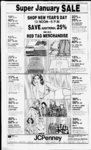
| OCR Text |
Show I t 1 DAVIS COUNTY CLIPPER, DECEMBER 29, 1982 13:092:0027, All of Lot 27, Eves Garden No. 5. PUD Sec 26, T5N-R2SLM. Total Tax $64.41 JoyceT. Wilcox, 12.049 0010, Beg NW Cor of SW 14 of Sec 9, 4N, 2W, SLM, East 3.32 chains, S 72 degs. 08, Raymond J. Eves Co. Inc 13.092:0028, All of Lot 28, Eves Garden No. 5. PUD Sec SLM: Total 26, T5N-R2Tax $64.41 Raymond J. Eves Co. Inc., 13:092 0029, Beg at th NW cor Eves Garden No. 5. Sec 26 of SLM: th S 0 degrees 02E 99 ft tj S'ly along the arc of a 282 57ft rad cur to the right 36.70 ft; th S'ly along the arc of a 332.57 ft rad cur to the left 43 19ft,thSOdegrees02'E 194 33 ft; th N 89 degrees 58E I 0 ft; th N 0 degrees 02W 194 33 ft; th Nly along the arc 33 ft .57 a of rd cur to the nght 43. 19 ft mol, th Nly along the arc of a 283.57 ft rad cur to th left 36.70 ft. mol, th N 0 degrees 02'W 99 ft: th S 89 degrees 58' W 1.09 ft to the pob. Cont. .009 Acres (Holding $4 03 Stop) Total Tax T5N-R2- Raymond J. Eves Co. Inc., 13.092 0030, Beg at the SE cor of Lot 22 of Eves Garden No. Sub, Sec 26; T5N-R2SLM th S 0 degrees 02E 30ft. th S 89 degrees 58 W 73 ft th N 0 degrees 02W 4 0 ft; th Nly along the arc of a 40 ft rad cur to th left 28 30 ft th N 89 degrees 58' E 82.60 ft to the pob Cont .052 Acres. (30 RW & Utility Easement) Total Tax ... $4 03 Tex L Robinson, 13.094 0007, Lot 7, Blk 5, Sunset Sub. Sec 26, 5N. 2W. SLM. Cont .153 $261 66 Acres. Total Tax Heber G. Hammon, 13.094 0037, Lot 3, Blk 4, Sunset Sub. Sec 26;T5N-T2W- : SLM. Cont .138 Acres. Total Tax $244 75 5 Margaret H. B. Jensen, 13:098 0076, All Lot 11, Blk I, Raymond Shupe Sunset Add. Situatd in Sec. 26, Tp 5N, Rg 2W, SLM, Cont. .17 Acres. Total Tax $345.39 Arbon Charles Scott, 13 099.0003, All Lot 3, Buena Vista Sub. situated in Sec. 26, Tp 5N, Rg 2W, SLM, Cont. .193 Acres. Total Tax $282.59 Gary E. Stoddard, 13 099 0022, Lot 22, Buena Vista amended, Sec 26, Tp 5N, Rg 2W, SLM, Cont. .187 Acres. Total Tax $309 96 Morris Leon Edwards, 13.100.0059, Let 59, Buena Vista No. 3. Sec. 26, Tp 5N Rg 2W. SLM, Cont. .22 Acres. Total Tax $318 01 Marlowe G. Palmer, 13:100.0088, Lot 88, Buena Vista No. 3, Sec. 26, Tp 5N Rg 2W, SLM, Cont. .18 Acres. Total $395.95 Tax Title Inv. Corp, 13 101.0011, Lot 11, Suburban Hgts Sub, Sec 26, Tp 5N, Rg 2W, slm, Cont. .20 Acre. Total Tax . . $433.95 Karen L. Brown, 14.074 0021, Lot Sub. 29, Blk F. Scotts-Dal- e Sec 35 tp5N, Rg 2W. SLM, Cont. .213 Acre. Total $432.34 Tax SYRACUSE ABC R. Miller, 12:040:-003- Beg on W line of a st (1000 W St) at a pt which is N OOdegs 03 50" East 1566 ft aaong sec line and N 89 degs. 56 10" West 33 ft fr Monu Marking SE cor of Sec 5; T4N-R2SLM: Thence N 89 degs. 56' 10" West 407.05 ft; North 00 degs. 03 50 East 107 ft: thence South 89 degs. 56 10 East 407.05 feet to W line of said st; thence South 00 deg. 03 50" West 107 ft along said W line to POB. Cont 1.00 Acres. $1,452 41 Total Tax Gerald J. Page, Jr., 12:040:-003Beg on W line of a st at a pt North 0 deg. 03 50 East 1245 ft along sec line and N 89 degs. 56 10" West 33 ft fr SE Cor of Sec 5: T4N-R2SLM: Thence N 89 degs. 56 10" W 407 ft; thence N 0 deg. 03 50 E 107 ft; thence S 89 degs. 56 10" E 407 ft to W line of said st; thence S 0 deg. 03 50 W 107 ft along said W line to POB. Cont. 1.00 Acres. $472.33 Total Tax Robert E. Valdez, 12:040:-004- Beg at a pt 440 ft N 89 degs. 53 03 West along the sec In and N 0 degs. 03 50" E 120 ft fr th SE Cor of SLM; and run thence N 0 deg. 03 50 East 226 ft; thence N 89 degs. 53 03" West 85 ft; thence S 0 W 226 ft; 50 degs. 03 thence S 89 degs. 53 03 East 85 feet to the POB. Cont. .44 Acres. Out of $13 89 Total Tax Brent L. Andrews, 12:049.008, ft Beg 181.32 ft N and 179.85 East of SW Cor of Sec 9, T4N-R2SLM: and th E 146.85 ft; thence S to N line of a road; 146.85 ft along thence N 148.32 ft Cont. .50 Acres. Total Tax 148.32 West 3.49 chains North 1.07 chains to Beg. Cont. .17 Acres. Total Tax $45.15 Brent L. Andrews, 12:049 0057, Beg 181.32 ft N and 326.7 ft E of SW Cor of Sec 9, T4N-R2SLM: Th N 100 ft; th W 293.7 ft to E In of a rd; th S 100 ft along sd rd; th E 293.7 ft to POB. Cont. .675 Acres. Total Tax $21.53 Selby G. Tanner, 12:052 0034, Beg at a pt 2780.5 ft W and 283 ft N fr SE Cor of Sec 10; T4N-R2SLM: West 140 ft; then N 1037 ft; th E 280.5 ft; th S 1320 ft; th W 25 ft; th N 212 ft: th W 115 5 ft, thence N 71 ft to POB. Cont 7 0927 Acres. Total Tax $160 45 Donald Rhoades, 12 053 0024, Beg at a pt N 0 deg. 07 41" East 1262 39 ft along Sec line and South 89 degs. 59' 35" W 181.50 ft and N 0 deg 07 E 871 99 ft fr SE Cor of 41 Sec 10; T4N-R2SLM. Said pt is also NE cor of Lot 10, Rhoades Lane Sub; and run thence N 89 degs. 59' 45 West 262.68 ft to E Bank of an irrigation ditch; thence N 0 deg 07 40" E 4 55 ft M or L, to S line of ppty of Syracuse City, thence South 89 degs. 59' 45" East 262.68 feet; thence South 0 deg 07 41 West 4 55 ft, M or L to POB Cont .03 Acres. Total Tax $3 47 Ken S. Wilcox. 12 053:0027, Beg on the S line of a str at a pt N Odeg. 07 41 E 1196.39 ft along sec line and South 89 degs. 59 35 West 33 ft fr the SE Cor of Sec 10, T4N-R2SLM. and run thence South 89 degs. 59 35 West 111.18 ft along South line of said str; th S 0 deg. 07 41 W 100.39 ft; th N 89 degs. 59 35" East 111.18 ft to W In of a str; thence N 0 deg 0T 41" Eat 100.39 feet al sd str to POB. Cont. 0.256 Acres. 382.72 Total Tax Paula W. Tams, 12.059 0073, Lot 73, Marilyn Acres No. 3, Sec 10, T4N-R2SLM, except the South 5.0 feet thereof. Cont. .20 Acres. Total Tax 369.53 Scott O. Towell, 12.0590079, Lot 79, Marilyn Acres No. 3, Sec 10. T4N-R2SLM; Cont. .213 Acre. $89 67 Total Tax Ronald R. Brooks, 12 059:-009Beg at the NW Cor of Lot 85 Marilyn Acre No. 3 amended; North 0 degs. 06 East 6.70 ft; South 89 degs. 54 East 73.55 ft; South 43 degs. 48 East 9.30 ft; North 89 degs. 54 West 80 ft to POB. Cont. .015 Acres. $3.47 Total Tax Richard P. Frongner, 12:060.-011All of Lot 116, Marilyn Acres No. 4, Sec 10; T4N-R2SLM: Cont. .195 Acres. , Randy W. Lewis, 1 2 In A at a st E the of on Beg E pt N 0 degss 03 50 1152.75 ft and S 89 degs. 52 E 33 ft fr S cor of Sec 4; T4N-R2SLM: Run thence S 89 degs. 52 East 217.8 feet; thence South 0 deg. 03 50" West 100 feet; thence N 89 degs. 52 West 217.8 feet; thence N 0 deg. 03 50" E 100 ft to POB Cont. .50 Acre. Total Tax $489.69 Bob B. Allred, 12.034:0020, Beg 183 feet N fr SE Cor of SW 14 of Sec 4, T4N-R2SLM: Thence N 2457 ft; th W 20 rds; th S 160 rds; th E 180 ft; th N 183 ft; th E 150 ft to POB. Less St Cont 19.23 Acres. Total Tax $325.77 Bob B. Allred, 12 034.0021, Beg on N line of st a pt 33 ft N of SE Cor of SW 14 of SLM: Th Sec 4, T4N-R2W 150 ft along N line of sd st; th N 150 ft; thence E 150 ft; th S 150 ft to POB Cont. .52 Acres. Total Tax $1,462.13 John Eugene Carter, 12:036:-000All of Lot 4, Kristalyn Gardens No. 1, Sec 4, T4N-R2SLM: Cont. .50 Acres. llTotal Tax $91.00 12.040 0032, David R. Miller. Beg at a pt 1871 0 ft North and W 220 ft of SE Cor of SE 14 of Sec 5; T4N-R2SLM: Thence West 220 ft; thence South 198 ft; thence East 220 ft; thence N 198 ft to POB. Cont 1.00 Acres. $60.43 Total Tax David PAGE SEVENTEEN ft thence W said rd; to POB. $15 98 $361.89 Total Tax Vivan W. Graham, 12:061 0012, All of Lot 12A, Villa Vista Unit Two Sec 10, T4N-R2SLM: Cont . .30 Acres. $359 80 Total Tax Dennis R. Price, 12:0610030, All of Lot 30, Villa Vista Unit One; Sec 10, T4N-R2SLM; Cont. .288 Acres. $352.86 Total Tax Debra L. Kazemini, 12:061 0034, All of Lot 34, Villa Vista Unit One; Sec 10, T4N-R2SLM; Cont. .286 Acres. $366.05 Total Tax Steven E. Lemon, 12:061:0046, All of Lot 46, Villa Vista Unit One Cont. 0.235 Acres. $382.72 Total Tax Debra P. Terry, 12:062:0047, All of Lot 47, Villa Vista No. SLM: 3, Sec. 10, T4N-R2Cont. .249 $378.56 Total Tax Michael J. Peterson, 12:062:-005All of Lot 47, Villa Vista No. 3, Sec. 10, T4N-R2SLM: Cont. .239 $373.69 Total Tax Thomas Newell Snyder, 12:062:-006All of Lot 63, Villa Vista No. 3, Sec. 10, T4N-R2SLM: Cont. .279 Total Tax $154.93 J. Scott Holliday, 12:062:-008- All of Lot 84, Villa V's-t- a No. 3, Sec. 10, T4N-R2SLM: Cont. .239 $400.78 Total Tax Kenneth W. Flint, 12:063.0097, All of Lot 97, Villa Vista No. SLM: 4, Sec. 10, T4N-R2- Cont. .25 $547.34 Total Tax Kenneth W. Flint, 12:063 0129, All of Lot 129, Villa Vista No. 4, Sec. 10, T4N-R2SLM: Cont. .33 $539.01 Total Tax Clyde . Wiseman, 12:064:0001, AH of Lot 1, Rhoades Lane Sub. Amend. Sec 10 T4N-R2SLM: Cont. .25 Acres. $414.68 Total Tax Michael W. Babcock, 12:064:-000All of Lot 3, Rhoades Lane Sub. Amend. Sec 10; T4N-R2SLM: Cont. .23 Acres. $479.97 Total Tax Raydolph D. Cook, 12:079 0013, Beg 17 79 rods W fr the NE Cor of the NW 14 of Sec 14: T4N-R2SLM: The E 17 79 rods; thence South 1211 ft M or L to Nly In of ppty thence N 36 conv in 612-69degs. 41 W 491 ft along said N line to a pt South of Beg. thence N 816.25 ft M or L to K)B. Cont. 6.83 Acres. $66.68 Total Tax Raydolph D. Cook, 12:079 0017, Beg 30 rds N and 133 ft E fr SW Cor NW 14 Sec. 14, TP4N, RG2W, SLM. East 2507 Ft, N 5 chains, West 40 chs. South 255 ft, E 133 ft. South 75 ft to beg. Less st cont. 19.52 Acres. $655.03 Total Tax Raydolph D. Cook, 12:079 0024, Beg 5 rds N of SE Cor of NW 14 of Sec 14 T4N, R2W, ' SLM, North 25 rds, West 115.2 rds. South 25 rds, E 115.2 rds to beg. Cont. 18.0 AzrPC Total Tax ce $175.04 Thurgood and Sons Inc., 12:079 0025, Beg on the S line of a str at a pt 1174.85 South 89 degs. 59 50 E along the Sec line and South 0 degs. 10 10 West 33 ft fr the NW cor of Sec 14, T4N-R2SLM: and run th South West 185 0 degs. 10 10 feet; thence South 89 degs. 59 50" East 1 16.67 ft; thence N 0 deg. 10 10" East 185 ft np nf said Sl- rt I Kpnrf 8 thence N 89 degs. 59' 50 West 116.67 feet to the POB. Cont. .50 Acres. Total Tax $684 14 James H. Rentmeister, 12 085.-000Beg 227.15 feet South ff NW Cor Sec. 15, TP4N, RG2W, SLM, East 143.3 ft, N 76 ft, W 143.3 feet to sec line, South 76 ft to bega. less st. cont. .19 Acre-- .. Total Tax $329 94 H. K. Stephenson Construction Co., Inc. 12.085.0036, Beg on South line of a st 33 ft S fr NE cor NW14 Sec 15, T4N-R2SLM. Thence W 149 ft, South 190 ft; West 115 ft; South 41 ft; W 66 ft; South 1716 ft; East 330 ft; thence N 1947 ft to beg, Cont. 14 15 Acres Total Tax $137.53 H. K. Stephenson Construction Co., Inc. 12.085.0037. Beg at SE Cor of NW 1,4 of Sec 15, T4N, R2W, SLM, West 10 0 chains, N 10.0 chains, E 10 0 chains, South 10 0 chains to beg Cont. 10 00 Acres. Total Tax $97.24 Raydolph D. Cook, 12 086 0014, Beg at a pt 20 chs South and 306 ft West fr NE cor Sec 15; SLM: Thence W ; 2334 ft; thence South 5 chains; thence East 40 chains; thence North 30 ft; thence West 153 ft, thence N 200 ft; thence W 153 feet; thence N 100 ft to POB. Cont 18.575 Acres. $197.27 Total Tax Harold S. Seamon, 12 087 0050, Beg 576 ft West of SE Cor SW U4 Sec 15, T4N-R2SLM: Thence N 666 ft, thence East 353 ft; thence N W 437 ft; 1314 ft; thence thence South 1980 ft, thence East 84 feet ot POB, Cont. 14.46 Acres. $140.31 Total Tax M. D. Glauser, 12 087:0060, Beg at a pt 443 ft N fr SW Cor of Sec 15 T4N-R2SLM: Thence North 5 ft thence E 10 rds thence S 5 ft th W 10 rds to POB. Cont. .019 Acres. $3 47 Total Tax Vern Dickerson, 12:091 0001, BBeg North 89 degs. 49 43" West 818 84 feet along sec In fr NE Cor of NW 14 of Sec SLM- South 4 16, T4N-R2degs. 50' West 435 6 feet. North 89 degs. 49 43" West ft; North 4 degs. 50 East 435 6 feet; South 89 degs. 49' 43 East 1 Foot to POB. Cont 01 Acres. Total Tax $3.47 Barber, 12 092.0048, Kenyon Beg at a pt N 0 deg. 08 41 East 256.15 ft along the 14 Sec In and N 89 degs. 43 ft fr the SW 30" East 286 Cor of the NE 1'4 of SLM: and run thence West 5 89 degs. 43 30 100.03 feet; thence S 0 deg. 16 30 East 107 ft, M or L, to the N line of a str; thence Ely 103 ft, M or L, along said str to a pt due S of the POB, thence N 107.50 feet, M or L, to the POB. Cont. .25 Acres out of No W or $55.75 Total Tax Norman Cook Hansen, 12:094:-002A pt of SE 14 of Sec SLM: Beg at ; 16, a pt which is N 0 deg 06' 28 East 1249.82 Ft along sec line N 89 degs. 53 32" W 174.24 feet from SE cor of said Sec 16 and run thence N 89 degs. 53 32 West 1154.69 feet to E line of Bluff Rd; thence N 43 degs. 50 05" West 217.15 ft to most S'ly pt of ppty thence N 46 conv in degs. 09' 55" East 111.95 feet; thence South 89 degs. East 1224.769 ft; 40' 47 thence South 0 deg. 06 28 West 230 44 ft to POB. Cont 6 62 acres less ppty conv. in 795-75- 6 .48 Acres remainder 6.14 Acres. $59.74 Total Tax 12.095-0004- , Glen H. Larsen, Lot 4, West Sunset View EsSec 16, T4N-R2tates No. SLM. Cont. .23 Acres. $198.66 Total Tax Hector R. Fuentes. 12 097 0006, All of Lot 6. Ranchettes ; West Sub; Sec 17; SLM: Except E 1.1 ft there of. Cont. .50 Acres $320 21 Total Tax Don L. Ciaythorne, 12.097 0009, All of Lot 9, Ranchettes West Sub; Sec 17; T4N-R2SLM. Cont. .50 Acre. (Except E l.l ft thereof) $338.27 Total Tax Michael J. Cowan, 12.097.0010, All of Lot 10. Ranchettes West Sub; Sec 17; T4N-R2SLM: Cont. .50 Acre. (Except E 1.1 ft thereof) Total Tax $337.58 Maik W. Ohlin, 12.097.0013. All of Lot 13, Ranchettes West Sub; Sec 17; T4N-R2SLM: Cont. .50 Acre. $384.81 Total Tax 12:097:-001Robert Kevin Payne. All of Lot 14. Ran chettes West Sub; Sec 17; T4N-R2SLM- - Cont. .50 Acre. $357 02 Total Tax S. Batson, 12 097:- Timothy 0017, All of Lot 17, Ran chettes West Sub: Sec 17; T4N-R2SLM: Cont. .50 Acre. $358.14 Total Tax David W. Thompson, 12.097:- 0021. All of Lot 21. Ran chettes West Sub; Sec 17; T4N-R2SLM: Cont. .55 Acre. $341.74 Total Tax Carlton J. 0022. All chettes T4N-R2- Doyle, 12:097:- of Lot 22. Ran West Sub: Sec SLM: Cont. 17; .53 Acre. Total Tax $330.63 P. Leshko, 12:097:- Michael 0025, All of Lot 25, Ran chettes West Sub; Sec 17; T4N-R2SLM: Cont. .48 Acre. $357.02 Total Tax Michael W. Bingham, 12:097:- 0026, All of Lot 26, Ran chettes West Sub; Sec 17; T4N-R2SLM: Cont. .47 Acre. $340.35 Total Tax Vernal J. Campbell, 12:097:-003All of Lot 33, Ran chettes West Sub; Sec 17; T4N-R2SLM: Cont. .50 Acre. $357.02 Total Tax Francis J. Moreno, 12 098:-003All of Lot 36, Ran chettes West No. 2; Sec 17; T4N-R2SLM: Cont. .53 Acre. $302.86 Total Tax Robert B. Boyd, 12 098.0053, All of Lot 53, Ranchettes West No 7 Srr 17; T4N-- . 7 28 Acres. Total Tax $81.38 Vern C Strand, 06 012.0056, Beg 26 11 chains West fr SE Cor of NE 1,4 of Sec 13, T2N-R1SLM: South 4.80 chains. West 3.885 chains. North 4 80 chains. East 3 885 chains to beg 1.85 cont. Acres. Total Tax $1,442.79 Jim L. Telford. 06 013 0016, Beg on S line of Pa6es Lane and West line of D and RG RR which is South 89 degs. 5U 30" West 214 5 feet to cen line of 800 West Street and N 0 degs. 09' 30 East 2347.59 feet and North 89 degs. 57' 24" West 552 28 feet and South 9 degrees 07' 06 West 33 42 feet fr South 4 cor of Sec 13. T2N-R1SLM Thence South 9 degs. 07' 06 West 1125 84 ft; thence South 89 degs. 54' 36" West 100 feet along a fence; thence N 9 degs. 07' 06" East 718 84 feet, thence South 89 57 24 East 90 ft; degs thence N 9 degs. 07 06" East 387 ft to South line of Pages Lane, thence South 89 degs. 1 24 East along thence South line of said line 10 ft to POB Cont. 1 79 Acrs. Total Tax $156.77 William Tommy Moss, 06 014 0026, Beg S 0 deg 23 15" East 347 13 ft along 14 sec line and South 89 degs. 52 41" East 829.54 feet along South In Pages Lane and South 0 deg 21 56" West 2227.18 ft along the E line of Sunny View Est Sub fr Cen Sec 13; T2N-R1SLM Said pt is also thence SE cor of Lot 48, Sunny View Est Plat "D": thence South 0 deg 21' 56" West 250 ft to the N line of st; thence S 89 degs 55 45" West 149 99 feet along said N line to E line of 700 W est Street thence N 0 deg. 21' 56" East 250 teet along said E line, thence N 89 degs. 55 45" East 149 99 feet to the POB Cont 86 Acres. Total Tax $386.26 Junior W. Skolaut, 06 015 0008, All of Lot 8. Charnell, Sec. $290 74 Total Tax Sam Lee, 06 035 0004, Lot 4 Telford Sub; Sec 23, T2N-R1Joseph R. Boureau, Jr., 12 SLM Cont . .95 Acres. All of Lot 59, Ran$169 43 Total Tax chettes West No. 2: Sec 17; T4N-R2Michael S. Telford, 06.035 0005, SLM Cont. .50 All of Lot 5, Telford Sub; Sec Acre. SLM Cont . Total Tax 23. T2N-R1$166.05 .95 Acres. Donald B. Hawkes. 12:098 0060, $169 43 All of Lot 60, Ranchettes Total Tax West No. 2; Sec 17; T4N-R2Vicor Construction Inc., 06 016 SLM. Cont. .60 Acre. 0005, Beg at thence SW cor Total Tax of Lot 24, Summertree Sub, a $161.70 sub of pt of thence NW I 4 of Teddy G. Morse, 12 098 0066, All of Lot 66, Ranchettes SLM Sec 24, T2N-R1W- ; West No. 2; Sec 17; T4N-R2Thence North 8 degs. 52' 40" SLM: Cont. .53 Acre. E 1.0 Ft; thence South 89 Total Tax $356.33 degs. 48 06" W 50 63 feet; John R. Allred, 12.098.0068, thence South 8 degs. 52 50" All of Lot 68, Ranchettes West 1 0 feet to thence SE West No. 2; Sec 17; T4N-R2cor of Lot 25 said sub; thence SLM. Cont .53 Acre. 89 degs. 48 06" East 50 63 Total Tax $341 74 feet to thence POB Cont. Eric J. Nelson. 12 098 0069, 001 Acres. $3 70 All of Lot 69. Ranchettes Total Tax T4N-R2West No. 2; Sec 17: Golden West Dev. Inc 06 036 SLM. Cont. .50 Acre. 0025, Beg 11 rods West and 4 5 rods South fr NE Cor NE Total Tax $76.33 1 4 Sec SLM. Bieck Baker. 12.099 0041, All 23, T2N-R1South 25.69 rods, East 100 07 of Lot 41, Ranchettes West T4N-R2No 2. Sec 17; rods. M or L, to W bndry In DRG RR RW. thence along SLM Cont. .53 Acre. $357.72 Total Tax bdry In in NE'ly direction to E of Beg. W to Beg. Cont Jerry A. Poulson, 12 099 0044. 16 39 Acre. All of Lot 44. Ranchettes West No. 2; Sec 17; T4N-R2TotalTax $1,455 23 Grant H Secnst, 06 036 0028. SLM. Cont. .53 Acre. $334 80 Total Tax Beg at a pt which is South 498 13 feet along the Section Mark D. Anderson, 12:099 0073, In and West 47 ft. fr th NW All of Lot 73, Ranchettes Cor of Sec 24; T2N-R1West No. 2: Sec 17; T4N-R2SLM. Thence South 155 feet, SLM Cont. .50 Acre. thence West 194 to the E ly $339 66 Total Tax line of a str: 1100 West str, Quinten C. Miller. 12:099 0075, All of Lot 75, Ranchettes thence S 25 ft along said str, thence E 1403.62 feet; thence West No. 2: Sec 17; T4N-R2N 180 ft; thence W 1209 62 ft SLM: Cont. .50 Acre. Total Tax to thence POB. Cont. 5 11 $353.55 David E. Black. 12. .099 0082, Acres $362 26 All of Lot 82, Ranchettes Total Tax Golden West Dev. Inc., 06 036 West No. 2, Sec 17; T4N-R2SLM. Cont. .51 Acre. 0029, Beg at a pt which is South 498.13 ft along sec line Total Tax $341.74 and East 1162 62 ft fr NW Brent K. Dumas. 12 099 0084, Cor of Sec 24. T2N-R1All of Lot 84, Ranchettes SLM Run thence S ISO ft. West No 2: Sec 17; T4N-R2SLM Cont. .51 Acre. Thence East 243 82 ft to W'ly line of D and RG RR RW, Total Tax $362.58 thence N 09 degs. OF 00" Kevin M. Homer. 12 099 0087, All of Lot 87. Ranchettes East 182.25 ft along said W'ly West No. 2, Sec 17; T4N-R2line; thence W 272 38 feet to POB. Cont. 1.05 Acres. SLM Cont. 51 Acre. $178 79 Total Tax 338 Total lax T2N-R1SLM1 Golden West Dev. Inc.. 06 036 M. Carruth, 12 099:- Thomas Cont. .237 Acres. 0031, Beg at a pt which is 0088. All of Lot 88. Ran South 678 13 ft along sec line $512 68 TotalTax Sub No. Sec West 2, chettes and W 241 ft M or L to E In G. H. G Investment Co , Inc., T4N-R2SLM. Cont 17; of A 4 rod rd fr NW Cor of 06:015 0020, All of Lot 20, 51 Acres. T2N-R1SLM Sec 24, T2N-R1Sec Charnell, 65 $399 Total Tax Run thence S 25.20 ft along SLM. Cont. .230 12 099 Lisa G. Norman. 0092, said W In; thence E 100 ft. Acres. All of Lot 92, Ranchettes thence S 155 ft; th E 1518 84 Total Tax $105 05 West Sub No. 2, See 17; ft to W'ly In of D and RG RR LaGrand DeWaal. 06.015.0047, T4N-R2SLM. Cont .51 All of Lot 47, Charnell. Sec RW; thence N 09 degs OF Acres. T2N-R100" East along said RW SLM: $334 80 Total Tax 182.46 ft; thence W 1647 437 Cont. .362 Acres. Bruce W. Christensen, 12:099.--009ft to POB. Cont. 6 455 Acres. TotalTax $117 61 All of Lot 93, Ran$493 34 Total Tax Victor M Kimball, 06 015:0049, chettes West Sub No. 2, Sec Jane Ritchey Dees, 06 036 0042, All of Lot 49, Charnell. Sec SLM: Cont 17; T4N-R2T2N-R1Beg on W line of st 36 ft SLM: .50 Acres. West of Cent In thereof at pt Cont. .245 Acres. Total Tax $355.64 15.75 chains S, M or L, and Total Tax 12 099:-009$105.79 C. Criddle, Stephen 3.70 chains West fr NE Cor Joel V. Hale, 06 015:0065, All of Lot 97, Ranof NW 14 Sec 24. TP2N. All of Lot 65, Charnell Plat chettes West Sub No. 2, Sec RG1W, SLM. West 65 rods, B. Cont. .237 SLM: Cont 17, T4N-R2M or L, to RR RW. thence Total Tax $105.05 .51 Acres. Sly along said RW 160 5 Richard Terry Henderson, 06:-01- 6 Total Tax $352.86 feet, MOL, E 65 rds to W 0066, All of Lot 66, Hill-weTaney G Brown. 12 099 0104, line said st to pt 366 ft N fr Plat C. Sec 13, T2N-R1All of Lot 104, Ranchettes SE Cor Lot 2, Blk 6, NMC SLM: Cont. .25 Acres. West Sub No. 2, Sec 17; Plat, thence N 160.5 feet to T4N-R2Total Tax $776 91 SLM Cont .50 Beg. Cont. 3.707 Acres, s. Acres. Danny A. Randall, 06.017 0003, Total Tax $612.55 All of Lot 3, Hillwest Plat A. $354.25 Total Tax Retta M Clark, 06:036.0045, Beg SLM: Sec 13, T2N-R1Armond D. Carter, 12.099 0106, on W line of St 36 ft W of Cont. .239 Acres. All of Lot 106, Ranchettes Cent In at pt 23.675 chains Total Tax $556 45 West Sub No. 2, Sec 17; South and 36.30 chains East T4N-R2Mark Allen Moffat. 06.017.0003, SLM. Cont .50 and 175.5 feet N fr NW Cor All of Lot 13, Hillwest Plat Acres. Sec 24. TP2N, RG1W, SLM. B. Sec 13, T2N-R1SLM: Total Tax $353.55 North 103.5 feet, West 268 0 Cont. .259 Acres. Sec. Title Co of Davis County, feet, thence S 21 ft, W 804 5 Total Tax $570.50 12.099.0110, Thence W ft of feet to railroad RW, thence Meridian Construction, 06:020:-00Lot 76 Rnachettes West No. SW'ly 85.0 feet, East 65 All of Lot 2, Willow-broo- k SLM. 2 Sec 17, T4N-R2rods, M or L, to beg, cont. Farm; Sec 13, T2W-R1Cont. .002 Acres. 1.90 Acres. SLM: Cont. .589 Total Tax $3.47 $597 1 Total Tax Acres. 12 099 C. 0111, Price, Gregory Earl William DeWaal, 06 $128 41 Total Tax All of Lot 111, Ranchettes Beg at thence SW Cor Mendian Construction, 06 020:- West Sub No. 2, Sec 17; of Grantor's Land (Being at a T4N-R20005, All of Lot 5. Willow-broo- k SLM: Cont .46 pt 200 ft W of thence inters Farm; Sec 13, T2W-R1Acres. of th W In of 800 W str and SLM: Cont. .405 Total Tax $354.25 th N In of 400 N str) at a pt Acres. 01 12:099 14, Azalia J. Weir, 6 40 chains N and 2,228 8 Tax Total $519.39 Ranchettes All of Lot 114, feet East from thence SW Meridian Construction, 06:020:- West Sub No. 2, Sec 17; Cor of thence NW 14 of Sec T4N-R20006, All of Lot 6, Willow-broo- k SLM: Cont .50 SSM. Thence 24. T2N-R1Farm; Sec 13, T2W-R1Acres, except the West 1.0 N 9 rods to thence N line of .364 Cont. SLM: Ft of said lot. Cont . 0.002 Grantor's land thence East 75 Acres. Ac Total 0.498 Acres. feet; thence South 9 rods to Total Tax $552.68 $353.55 Total Tax N line of 400 N str; thence W Mendian Construction, 06.020:- Security Title Co., 12 099:-011along thence said N line of 0007, All of Lot 7, Willow-broo- k All of the E 1.1 foot of 400 N st a dist of 75 ft to th Farm: Sec 13, T2W-R1Lot . Ranchettes West No. POB. Cont. .26 Acres. Out of SLM: Cont. .365 2 , 0.0049 Acres Was 1 or 15 remaining of Total Tax $387.77 Total Tax $89.57 and Jay Roush, 06.037:0003, Beg on Meridian Construction, 06 020:-001Total Tax $3.47 W line UP R R Co. RW 74 All of Lot 12, Willow-broo- k Michael D. Thurgood, 12:106:-001- 5 rds N and 1147.224 feet West Farm; Sec 13, T2W-R1Beg at a pt s along the from SE Cor NE 14 Sec 24, SLM; Cont. .39 Acres. sec line 1602.48 feet and T2N-R1SLM: West Total Tax $92.53 North 52 degs. 34 10" West 13.674 ft; South 52.8 feet to Mendian Construction, 06.020:- 1069.7 feet and North 49 Nly In said RW; North 21 0014, All of Lot 14, Willow- West 1182.6 degs. 17 30 degs. 52 East along said RW brook Farm; Sec 13, T2W-R1feet from Eat 14 cor of sec 56.6 feet to Beg. Cont. .008 SLM: Cont. .39 Acres. SLM: and run Acre. Total Tax $92.53 thence N 46 degs. 17 30 $3 70 Total Tax Meridian Construction, 06 020:- West 179.0 feet; thence Evan W. Ashby, 06037:0007, WillowAll 15, of Lot 0015, 38 30 East 89 North degs. Beg at a pt 1381 feet N and brook Farm; Sec 13, T2W-R1249.12 ft along 14 sec In; 1327.5 feet W or SE Cor of Acres. SLM: .39 Cont. S 30 42 43 thence degs. NE 14 of Sec 24; T2N-R1Total Tax $92.53 POB. the West 173.26 feet to SLM. Run thence N 80 ft; Meridian Construction, 06 020:- Cont. 0.355 Acres. thence West 139 feet M or L WillowAll Lot 16, of 0016, Total Tax $2,063.66 to Ely line of a hwy; thence brook Farm; Sec 13, T2W-R1S'ly 80 ft M or L along E line SLM: Cont. .39 Acres. of said why to a pt due W of Total Tax $92.53 pt of Beg; thence E 146 ft M Construction, 06:020:- WEST BOUNTIFUL Meridian All .26 or L to POB. Cont of Lot 17, Willow-broo- k 0017, Acres. ABJ Farm; Sec 13, T2W-R1Total Tax $107.56 SLM: Cont. .429 Walter Joseph Elsby, 06:037:-002Kim D. Stander, 06.008 0042, Acres. Beg 14 rds S and 9.4 Beg at NW Cor of Lot 1 Total Tax $96.39 rds 1155.1 ft) East fr NW Cor Charnell Sub Plat A" Meridian Construction, 06.020.- of NE 14 Sec 24; T2N-R1thence South 79 degs. 18 0018, All of Lot 18. Willow-broo- k 30 SLM: Thence S 405 ft; E 111.65 ft thence N 8 Farm; Sec 13, T2W-R1thence E 5.0 rds; thence N degs. 57 E 90 ft thence N 79 SLM; Cont. .512 405 ft thence W 5.0 rds to degs. 18 30" West 111.65 ft Acres. POB. Cont. .77 Acres. thence South 8 degs. 57 $104 85 TotalTax Total Tax West 90 ft to POB Cont. .23 Meridian $350.59 06 020:- Construction, 1 Rex L. Maughan, 06 037:0064, and Acres. Out of 0019, All of Lot 19, Willow-broo- k extra from pickup or Beg on E line of a 50 ft st N Farm; Sec 13, T2W-R10 deg. 34 East 825 ft along SLM: Cont. .599 Total Tax $105.05 projected cent In said st fr pt Acres. Ronald L. Smith, 06.012.0015, marking cent In inter of 400 $116.59 TotalTax N St and said 50 ft st; North Beg 4.0 ft South and 21.6 feet Michael S. McAdams 06.022:-003South 89 degs. 56 14 East 89 degs. 41 East 26.38 feet Sunny View Estates, to true pt of beg; North 89 of NW Cor of SE 14 of Sec Plat D. Sec 13; T2N-R1SLM: Thence 13, T2N-R1degs. 4F East 328 62 ft to pt SLM: Cont. .201 Acres. South 89 degs. 56 14 East given as 74 rds N and 70 rds Total Tax $482.80 85 ft; thence South 1 deg. 11 W of East 14 cor Sec 24, Richard I. Campbell, 06:025.0015 T2N-R1South 0 deg. 34 East 277.3 feet to N line of All of Lot 15, Casa Verde West 45.97 feet to existing st; thence North 89 degs. 56 Est. A. Sec 13; T2N-R145 fence on RR RW; South 21 West 85 feet along N line SLM; Cont. .274 Acres. of said street; thence N 1 degs. 53 West 98.72 feet Total Tax $112.57 deg. 11 West 277.22 ft to the Stan B. Knighton, 06:025:0020 along said fence: North 89 POB. Cont, .54 Acres. degs. 41 West 294 12 feet to All of Lot 20, Casa Verde $568 92 Total Tax E line said st; N 0 degs. 34 Est. A. Sec 13; T2N-R1Donald Ben Dallas, 06:012:0045, East 35.81 feet to pt of curSLM: Cont. .283 Acres. vature with a 3794.72 feet rad Beg at pt South 8.94 chains, Total Tax $723.64 East 1036.65 feet from NW Keith J. cur to rt; thence alog said cur Ungerman ,06:034:0036 for an arc dist of 102.01 feet Cor of NE 14 of Sec 13, Beg at a pt W 863.31 feet and T2N-R1SLM: South 3.855 to beg. Cont. 1.00 Acre. N 82.5 feet fr SE Cor of Sec Total Tax $839.82 chains, West 2.535 chains. SLM: Run 23; T2N-R1North 3.855 chains. East N. Craig Murphy, 06 038 0007, thence N 0 deg. 26 East 66 ft 2.535 chains to Beg. Cont. M M or L to a pt due West of a Beg at a pt 5.25 chains N and or L 1 .00 Acre. 34.7 feet West fr W 14 Cor pt 3.68 chains West and 37.82 $440.39 Total Tax Sec 24; T2N-R1chains South of the E F4 cor SLM Vern C. Strand, 06:012 0049, Thence W 11.5 ft; thence S of said Sec 23; thence E 554 509.6 feet; thence East 11.5 Beg 26.11 chains West fr SE feet M or L to W line of a st; Cor of NE 14 of Sec 13, ft; thence N 509.6 feet to thence South 66 feet M or L T2N-R1SLM: North 18.79 POB. Cont. .13 Acres. along said st to a pt due East Total Tax chains, West 3.885 chains, of pt of Beg; thence West $6 66 South 18.79 chains. East Jack LeRoy Hepworth, 06.038:-OO'- m 554.5 feet M or L to POB 3 885 chains to Beg. Cont . Cf.nl 85 Am-iIka 13 chs S5 Iks 6. 3 R2W; SLM. Cont. .50 Acre. Total Tax $353.55 chs 65 Iks W fr NE Cor ot SE 1 4 of Sec 23, T2N-R1SLM South 58 feet. East 153 ft, North 58 feet. W 153 ft to beg. Cont. .20 Acres. $276 69 Total Tax Kenneth E. Jervis, 06.038 0054, Beg at a pt 1040 ft. M or L. E and 61 59 feet N of a pt which is 412 34 feet South and 1072 50 feet E fr NW Cor of SW 1 4 Sec 24. T2N-R1SLM, thence E 272 83 feet, M or L. to W line of a st; thence N 63 75 feet along said W line; thence W 273 05 ft. M or L, to a pt N of beg. th South 63 75 feet. M or L. to POB Cont. 40 Acres $342 76 Total Tax Vicor Construction Inc , 06 040 0002, All of Lot 2 amd, Summertree, Sec 24, T2N-R1SLM Cont. 18 Acres . . .$82 0" TotalTax. Vicor Construction Inc . 0t 040 0014, All of Lot 14 amd. Summertree, Sec 24 T2N-R1W- , SLM Com 10 Acres $470 45 Total Tax Vicor Construction Inc , 06 040 0015, All of Lot 15 amd. Summertree. Sec 24. T2N-R1SLM Cont 10 Acies $59 83 TotalTax Vicor Construction Inc . 06 040 0016, All of Lot 16 amd. Summertree, Sec 24. T2N-R1SLM Com 10 Acres TotalTax $59 81 Vicor Construction Inc . 06 040 0017, All of Lot 17 amd. Summertree. Sec 24. 12V R1W.SLM Com 11 Acres SbO 5i TotalTax Vicor Construction Inc . 06 040 0018, All of Lot 18 amd Summertree. Sec 24. T2N-R1SLM Cont 20 Acres 568 29 Total Tax Vicor Construction Inc . 06 040 0019, All ot Lot 19 amd. Summertree. Sec 24. T2N-R1W- . SLM Cont II Acres TotalTax $60 57 Vicor Construction Inc . 06 040 0020, All of Lot 20 amd. Summertree. Sec 24. T2N- R1W, SLM Com. 13 Acres $61 11 Total Tax Vicor Construction Inc , 06 040 0021, All of Lot 21 amd. Summertree, Sec 24. 12N-R1SLM Cont 17 Acres TotalTax $66 07 Vicor Construction Inc . 06 040 0022, All of Lot 22 amd. Sec 24 12V Summertree, R1W. SLM Cont 12 Acies Total Tax $6111 Vicor Construction Inc . 06 040 0023, All cf Lot 21 amd. Sec 24. T2V Summertree. R1W. SLM Cont 11 Acres Total Tax $60 57 Vicor Construction Inc . 06 040 0024, All of Lot 24 amd. Sec 24. T2N-R1Summertree. SLM Cont 16 Acres $65 11 Total Tax Vicor Construction Inc . 06 041) 0026, All of Lot 26 amd. Sec 24. T2N-R1Summertree, SLM Cont 13 Acres Total Tax $6111 Vicor Construction Inc.. 06 040 0027, All of Lot 27 amd. Summertree. Sec 24. T2N-R1SLM Com. 13 Acres $6131 TotalTax Vicor Construction Inc , 06 040 0028, All of Lot 28 amd. Sec 24, T2N-R1Summertree, SLM Cont. .13 Acres $61 11 Total Tax Vicor Construction Inc., 06 040 0029, All of Lot 29 amd. Sec 24. T2N-R1Summertree, SLM Cont. .13 Acres $61 II Total Tax Vicor Construction Inc.. 06 040 30 amd, 0010, All of Lot Sec 24. T2N-R1Summertree, SLM Cont .13 Acres $61 31 Total Tax Vicor Construction Inc , 06 040 0031, All of Lot 31 amd. Sec 24. T2N-R1Summertree, SLM. Com. .13 Acres TotalTax $61 II Sec 23 and 24 T2N-R1SLM Cont .537 Acres . $124 92 Total Tax . . Tingey Real Estate. 06 042 0004. All of Lot 4, Marlinda West, Sec 23 and 24 T2.VR1W; SLM Cont 3 Acres $109 95 TotalTax Vicor Constr Inc . 06 042 0006. All of Lot 6. Marlinda West. Sec 23 and 24 T2N-R1SLM Cont 399 Acres $110 69 TotalTax Security Title Co of Daws Co 06 042 06010. All of Lot 10 Marlinda West. Sec 21 and 24 T2N-R1SLM Cont 402 Acres $110 69 TotalTax.. . Vicor Constr Inc. 06 042 (Kill. All of Lot 11. Marlinda W est Sec 23 and 24 T2VR1W. SLM Cont 402 Acres $110 69 . TotalTax . Secuntx Title Co of Daws Co 06 042 0019. All of Lot 19 Marlinda West. Sec 21 ad 24 T2N-R1SLM Corn 4U Acres TotalTax $112 1" Vicor Constr Inc. 06 042 IK120. All of Lot 20. Marlinda West Sec 23 and 24 T2VRIW. SLM Cont 40 Acres TotalTax $112 1" Secuntx Title Co ot Daws Co . All ol Lot 21 061)42 0021 Marlinda West Sec 21 ad 24. T2N-R1SLM Cont 45 Acres TotalTax. $112 TotalTax $112 17 Tinges Real Estate. 06 042 0022. All of Lot 22 Marlinda West Sec 21 and 24 T2VR1W. SLM Cont 415 Acres 1" 1 Tingey Real Estate 06 042 002 . All of Lot 23 Marlinda West. Sec 21 and 24 T2VRIW. SLM Cont 415 Acres TotalTax $112 P Secuntx Title Co ol Daws Co . 06 042 0025. All ot Lot 25 Marlinda West Sec 23 ad 24 T2VRIW. SLM Cont 41" Acres TotalTax $112 1" Aaron G Geoige. 06 04h (XI2K. All of Lot 5 Fackrell B Sec SLM Cont 24. T2N-R1. 17.1 Acres SI 19 02 TotalTax. Daws Co Reads Mix Concrete Co . 06 048 0059. Beg on S line of 5th So St at NW Cor 245-62at pt ppty cons in 19 "6 East and S chains 602 42 ft and W 5( ft fr NW Cor Sec 25. T2VRIW. SLM. 5 0 degs 18 E 282 97 ft. M or L. to pt 11415 chs S fr N line Sec 25 to S line West Btfl Txxn West 160 07 ft. m or to E In pptx cons in 244-68' W 14 N 0 degs K) 282 9". ft. M or L to S line st. N 89 degs IF E along said S line 160 07 ft m or to beg Cont 2 32 Acres TotalTax $52)56 McKas M Loxeland. 06 048 0070. Beg on S line of st hv 50 ft S of Cen In thereof at pt 602 42 ft S. M or L. and 1191 17 ft N 89 degs 3F E fr NW cor Sec 25. TP2N. RG1W. SLM. North 89 degs IF East 105.15 ft South 0 deg 06' 10" East 282 97 feet B M or L. to S line of W Tossn. W 188 ft. M or L to W' In grantors land. N 0 deg 2F 30" W 35 37 leel. M or L. S 88 degs 37' 30" East 84 88 feet, thence N 0 deg 06' 30" West 247 6 feet to Beg Cont. .69 Acres $399 85 Total Tax Jex Hepxxorth. 06 047 0067. Beg & In on th W'ly R-of U shwy 89-9at a pt 175 ft W & 146 133 rds N fr th SE cor of the NE'4 of Sec 24. T2N-RIW- ; SLM th S 203 5 ft. th W 200 ft to a pt on th SE'ly Noaccess In of interstate 5, th NE 236 ft. mol. alg sdSE'lv In to a pt 80 25 ft W fr th pob. th E 80.25 ft to th pob Cont 65 Acres together with a desc R-Total Tax . $92 78 J Clvde Brasier, 06 039 00O6. Beg 373 66 ft W & 426 67ftNFrSE cor Sec 24; T2N-R1SLM th E 200 ft to W line of R-of R-31 ft; th hy 91, th S alg sd W 200 ft to pt 31 ft S of pob, th N 31 ft to pob. cont .145 Acres Together with R-Total Tax $321 73 Lyman B Wight. 06 039 0070, BegS 1345 45ft &W 1038.1 ft 6 N Odeg 23' W 10 60ftfrNE cor of SE1 of Sec 24. T2N-R- 1 W, SLM & th W 85 88 ft. th N 148 5 ft mol to S In of a st, th E 84 89 ft aig sd st, th S 0 deg 23' E 148 5() ft to pob Cont .327 Acres TotalTax$2.2l4 67 Robert L Glines. 06 039 0071. Beg S 1345 45 ft & W 943 14 ft fr NE corofSEU Sec 24. T2N-R1SLM. thN Odeg 1730" W 149 92 ft.th S 89 deg 40'52" W 95 21 ft. th SO deg 2300 E 149 39 ft. th E 94 97 ft to pob, cont 0 318 Acres Total Tax $626.08 David L Nash. 06 039 0079. Beg 209 ft W fr the NE cor of Grantors Land at a pt 380 ft W' and 159 00 ft N fr the SE cor of the SE'4 of Sec 24.T2VRlW.run th W 800 ft mol to th E In of ppty cons to the st road com bv deed in th S 1 deg 02' W 124ft alg sd E in; th E 807 ft to apt 209 ft W of the Win of U S Hwy 91. th N 123 75 ft to the pob Cont 2 28 Acres together with a perpetual R-Total Tax $2,332 66 Self Storage Inc.. 06 039 0086, Vicor Construction Inc., 06 040.- 0032, All of Lot 32 amd, Sec 24, T2N-R1Summertree. SLM. Cont .14 Acres. Total Tax $62.05 Vicor Construction Inc , 06 040 0034, All of Lot 34 amd, Sec 24, T2N-R1Summertree. SLM Cont 14 Acres $63 85 Total Tax Vicor Construction Inc . 06 040 0035, All of Lot 35 amd. Sec 24. T2N-R1Summertree, SLM. Cont. 10 Acres. $59 83 Total Tax Vicor Construction Inc., 06:040 0036, All of Lot 36 amd, Sec 24. T2N-R1Summertree, SLM Cont, .10 Acres Total Tax $59 83 Vicor Construction Inc., 06.040.- 0037, All of Lot 37 amd, Sec 24, T2N-R1Summertree, SLM: Cont. .10 Acres. Total Tax $59 83 Vicor Construction Inc., 06.040:- 0038, All of Lot 38 amd. Sec 24, T2N-R1Summertree. SLM: Cont. .10 Acres. Total Tax $59 83 Vicor Construction Inc., 06.040 0039, All of Lot 39 amd, Sec 24. T2N-R1Summertree, SLM: Cont. .10 Acres Total Tax $59 83 Vicor Construction Inc., 06 040 0040, All of Lot 40 amd, Sec 24, T2N-R1Summertree, SLM: Cont. .10 Acres Total Tax $59 83 Vicor Construction Inc. Common, 06:040 0045, Beg at a pt 106.07 ft W fr thence SE Cor Beg 463 05 ft W&8I6 66ft NOof Lot 8, Summertree Sub. SE cor Sec 24. T2N-R1Amd, pt of thence NW 4 of SLM W 268 95 ft, S 102.33 ft, Sec 24, T2N-R1SLM E 268 95 ft: th N 102.33 ft to Thence W 31.08 ft to thence E line of Lot 9 said sub. beg, cont 0 69 Acre together with perpetual R-Total thence N 15 degs. 08 15" W Tax $648 69 5 05 feet to thence S'ly line of a st thence ETy 32 19 feet Kerrv William Frampton, 06 045 0003. Beg at NW cor along thence arc of a 50 ft Lot 2, Evergreen Acres Sub. rad cur to thence left, thence Sec 24. T2N-R1S 15 degs. 08' 15" East 23 17 SLM; th S 89 deg 57 E 101 56 ft; SO deg ft to thence POB Cont 010 03 W 100 ft; N 89 deg. 57 W Acres. 100 84 ft. thN Odeg. 03 E 100 $3.70 TotalTax ft to beg. Cont .23 Acres. TotInc. ComVicor Construction al TAx $567.71 mon A, 06 040 0046. Beg amd at a pt 447 46 ft West and Jen D. Kunz, 06 045 0014, Beg at South 65.29 fts 0 degs. i9' pt S 68 deg 12' E 55.6 ft fr SW cor of Lxt 12, Sec 24, TP 2N 34" E 88 67 feet fr thence N RG 1W, SLM, S 68 deg 12 E 14 cor of Sec 24, T2N-R164 4 ft to SEcorsdlot 12, N 21 SLM: Thence South 0.50 feet deg 48' E 27.5 ft, th alg 75 ft to thence N line of a st. rad curve to nght 22.5 ft to SE thence E 200 ft to thence W cor sd lot 12, N 42 deg. 10 W line of another street; thence 90 2 ft to Ely In state road, th S N .50 ft; thence W 200 ft to 13 deg 25 W 90.2 ft to th POB. Cont. .002 Acres beg. Cont. 0.11 Acre. Total Total Tax $3.70 Tax $202.76 Vicor Construction Inc., 06 040.-004All of Lot 25 amd. Robert M. Arbuckle. 06:049 0057, Beg on N In of 5th S st 444.57 ft Summertree. Sec 24. T2N-R1W & SLM. Cont. .15 Acres S89deg.50W77.22ftfr W In of hy 91 , which (Was 064)40-0025- ). pt is 10 80 W chs Total Tax $64 59 &S2deg 30E508 16ft fr NE cor Sec 25. T2N-R1Tingey Real Estate. 06:042 0001, SLM; N 2 deg. 30 W 218 ft alg All of Lot 1, Marlinda West. W In grantors land; N 89 Sec 23 and 24 T2N-RIdeg 50 E 85.34 ft; S 0 SLM: Cont. .536 Acres. deg. 12 E 217.84 ft to N In sd 5th So. St; Total Tax $141 82 Tingey Real Estate, 06:042 0003. Ail ot Lot 3. Marlinua nest. (Continued |