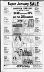
| OCR Text |
Show nr I I DAVIS COUNTY CLIPPER, DECEMBER 29 1982 th S 89 deg 50' W alg sd N In 77 22 tt to beg. corn. 0 386 Acre Total Tax Si. 048 98 WEST POINT ABC Dee McFarland. 12 023 0021. Beg on S In of st 95 roda E & 34 ft S of NW cor Sec 3, T4N R2W SLM.E SOftS 100 ft, W 80tt th N 100 ft to beg, cont 183 Acre Total Tax 4246 42 Rickv C 1 vcitchell, 2 023 tH)26. Beg 309 ft N 4 743 ft E r Stt cor of NW ' Sec 3. T4N R2W , SLM th S 38tt H'N'k fT N 39 ft - 20 It N 99 ft. th W 83 ft to beg Cont 2s Aues Tot 68 al Tax 1 eon Peterson. 12 023 0061 Beg a! a pt 120 rods f of NW cor ol See 3 14N R2W SLM Incitv ol West Pom! run th E 19 It, ' PT ti th f th S MOL TO AN 1 X1ST PI N( P IN 1 H S 2 tl4 th 1 207 9 It th S 13 dee 29 P '23 63 It th S 984 8 It IhWK S ,'PT TH N 6" ft to pod Cont 23(H) 5890 89 Acres lotal lax 1 eon Peterson 12 023(8)62 Beg a' a pi 120 rods p A. HT1 It S Ir NW cot ol 5KPC s T4N R2W SI M th S 96y tt mol to S In ol NW ' 4 ot sd sec 3 th660 0 'll N 969 It th W 660 ft mol to rim font 14 68 ares lotal P' la K 83(19 out s rein lames 12 1)37 (HI2II bci on the 1 In ol a canal R W t a ft 4 p! S alg Ih sec In 8()3 266 x2 It It th N W cot ot Sec - 4N R2W SI M run th I I tt th S 0 deg IP p 2'6 III It th W 462 88 It to the P In ol sd R W. th N 22 deg 34 W 2"" 92 ft alg sd R W to pub tocc ihcr vc Oh t ight ol wav 36" ( s oni 3 Acres (12 otal T lax HaOe A Hirrix 4104 63 12 038 (88)3 Beg a a pt P 326 93 (t alg sec In fr T4N-R2N 4 cor ot SPf C ' SI At th 1 "(I 3 ft th S deg 32 p 33 03 f, th E 2ft th S 2 deg 46 W 39 48 ft . th W ' 68 3g it th N 0 eg 02' 13 E 404 239 32 ft to pob Cont 5200 92 Acres Total Tax ee Thurgood 12 038 (8)18, John Beg N 89 deg 36' 47 W 13200 ale Ihe sec Si 3 I4N deg 03 3( cleg 36 47" Ir ih NE cor of In Paice. etal, 042 0013, Beg on S In of pt 660 ft S 4 20 chs W Ir NE cor of N W1 Sec 6.T4N-R2W- . SI M th E 660 ft. mol, alg sd S In to W tn sd district, th S 338 23 tt alg sd W In, th W 621 ft. th S S 32 chs th W SO cits, th N 689 37 ft mol. lo pob Cont 5 3S Acres Total 537 91 Tax Cont Tax Beg 80 rds E of SAV cor Sec 6. T P 4N RG 2W, SLM N 34 rds 8'5 ft. E 444 5 ft S S4 rds 8': ft. AV 544 5 ft to 43 Acres Total beg Cont 52S0 2I . . . Tax W alter B Flint, 13 031 0005. A pt T5N-R2of SW' of Sec 29. SI M Beg at a pt on N side of 300 N st ah is NO deg 13 18" E 33 ft 4 S 89 deg 58 1PE33 ft tr SW cor of sd SW'. th N 0 A' 18 E 150 ft. th S 89 deg deg sg' IP E 8S ft th s 0 deg 13 18" W' 40 ft to N Inofst.th N 89 deg S8 WSSftalga sd N In to pob. Cont 293 S3'9 82 . Acres Total Tax. Wavne L Pverelv. 14 031 OOP. Beg at a pt ah is N 89 deg 59' W 1234 4 ft alg th ' sec In fr th 044 0019. IP cen of Sec 29. T5N-R2W- ft.thS2ft.th Garv T th N 89 deo 59' W 100 (8) ft. th SO deg 25' 20" E 1023 OS ft. thN 46 deg 06' 40 F 137 78 ft algth N fence In of Lavton Canal, th N 0 deg ' 2S 20 W 927 50 ft to the pob Cont 2 239 Less so ft on N side ah is in the road Acr total Acres Total Tax . 124 $75 82 Garv Birch. 14 040 (8)12. Beg at a E 186 67 ft pi S 89 deg 38' 10" algth sec In N 0 deg 44'33" E lo W In of sd sec 86 67 ft cont 13 2 4 par ti th SW cor of the SE'iofSec so T3N R2W . SLM th N 0 deg 44 33" F 186 63 ft. th S 89 deg 38 10" E 111 0 ft. th S 0 deg 44 33" W 186 63 89 ft. th N 89 deg 38' 1(1 W 11.0 ft to the pob Cont 47 Acre Total Russell William 14 Tax Page, Ir NE cor of Sec 31. T5N-R2SI M th S 7 rds. th W 22 8st rds. th N 7 rds. th E 22 8S- rds to beg. cont I 00 $248 69 . Acres Total Tax Page. 14 044 (8H)s. Beg N Odeg 04' E 99 ss ft alg sec In fr SE cor of Sec H. TSN R2W; SLM th N w 100 ft. th N 72 89 deg W 36 9 ft to E'ly In of 30 deg I avton th N 21 Canal R-S R-deg 02' W 26 ft alg sd th N 68 deg S6' E 15 ft alg sd R W.thN 21 deg 04' W 39 91 144 9 ft to sd It alg sd Sec In. th SOdeg 04' W 78 45 ft alg sd Sec In to pob Cont 18 $7 58 Acres Total Tax Arthur R Lofswold 14 044 0040. Beg 592 ft N fr SE cor Sec 3. TCN-R2SLM th N 84 2 ft, W 29 98 ft. S 15 deg 46' E alg canal R-to pt W of beg , th E 2S6 21 ft to beg. Cont 50 $360 31 Acre Total Tax Stuart Wheelwright, 14 044 0047. Beg N 89 deg 43' W 375 ft alg ', sec In fr SE cor of Sec 3 , SLM th N 0 deg 04 E 396 ft. thN 89 deg 43' W 90 ft. th S 0 deg 04' W 3 ft to sd sec In, th S 89 deg 43' E 90 ft alg sd sec In to pob Cont 8 15 Acres. $125 86 Total Tax Security Title Co of Davis Co . 14.046 0033. Beg at a pt N 662 ft alg sec In & W 1 .320 ft fr SE cor of NE1. of Sec 32. T4N-R2SLM. run th W 15 ft mol to exist fence In: th N alg exist fence In 688 ft. th E 15 ft mol to a pt N of pob, th S 688 ft to pob Cont. .24 acres. Total Tax-- - OlesAo . $16 68 . ' aLEUlfi 14 $123 59 Murrav R E Dev Corp , 14 049 188)2, All of Lot 2 Page Estates Sec 72. T5VR2W; Cont 28 Acres Total SLM $676 13 Tax Ronald W Halbert, 14 049(88)4. All of Lot 4, Page Estates Sec SLM Cont 28 72, T5N-R2$8189 . Acres Total Tax Ronald W. Halbert. 14 049 0005, All of Lot 5. Page Estates Sec SLM Cont 28 32. T5N-R2$78 85 Acres Total Tax . Dick Hirabavashi. 14 049 0011, All of Lot 1. Page Estates Sec SLM Cont 35 32. T5N-R2$8189 Acres Total Tax Const M&J Co.. Inc. 17 049 0017. All of Lot Page Sec 32. T5N-R2W- , SLM Cont 47 Acres. Total $84 16 Tax M&J Const Co Inc, 14 049 0018, All of Lot 18. Page Estates Sec SLM cont 46 32. T5N-R2$84 92 Acres Total Tax . Dale T. Smedlev. 14 049 0020, All of Lot 20. Page Estates Sec 32. T5N-R2SLM Cont .28 . .$78 83 Acres Total Tax Dale T Smedley. 14 049 0027, All of Lot 27. Page Estates Sec 72. T5N-RISLM Cont .28 . Acres Total Tax . ..$78 83 Dale T. Smedlev. 14 049 0034. All of Lot 74. Page Estates Sec 32. T5N R2W. SLM Cont 28 Acres Total Tax . . $78 83 Dale T Smedley. 14 049 0078, All of Lot 78. Page Estates Sec 72, 14 SLM. Cont Acres Total Tax .... $78 T5N-R2- 046 0042, Beg 28 85 1st Sec Bank of Utah. 14 031 0001. All of Lot I. Skv West Estates Sec 32. T5N-R2No SLM Cont. .33 Acres Total S Russell . Darrel R Page, etal, 14 048 0047, Beg at SE cor of SE'A of Sec SLM. th N 203 32. T5N-R2ft. th W 72 5 rds, th S 207 ft. th E 7.25 roda to beg Cont 426 Acres. Total Tax ... $277 57 042 0019. Beg at a pt 66 rds William Inc Sec 32. T3N-RISLM. th S 89 deg. 54' 42" E 200 ft alg thS In ofstth SOdeg 02 E 210ft. th N 89 deg 34' 42" W 200 ft. th NOdeg 02' W 210 ft to lh pob Cont 923 Acres Total 521 23 lax Lucas Const 048 (8128. Beg al th NEcor ofLol 17. Skv West EstsNo I, Sec 32. T3N-R2SLM at a pt S 89 deg 36 47" E 733 73 ft & NOdeg 07 47 W 761 ft fr th S'4 cor of Sec 72. th N 0 deg 0347 W 160 3 ft, th W 432 87 ft, th S 88 93 ft. mol. to th NW cor of lot 7 of sd sub. th N 84 deg 3617" E 110 ft. th S 37 deg 4328 E 91 38 ft. thN 89 deg 36 13" E 286 83 ft to th poh. Cont I 438 Ac Total Tax .. . $74 30 Glen W hiting. 14 048 (8)37, Beg at a pt on th S In ot 8(8) N sir. w h is N 89 deg 34 42" W 107 ft S. S Odeg 02' E 2s fl fr lh E 'A cor of 14 Estates ; SI M ot sd ppty Acres Total M2 13 W Perrv. 14 048 0027 Beg at a pt E 280 5 ft alg sec In & N 921 3 ft fr S'A cor ot Sec 32.T3N-R2. SLM. th N 96 2 ft.thT 432 87 W' 452 87 It to poh Cont I (8) Acres Total Tax . $112 97 12 12 18 Darrell ha id at a Htdeharu Deb Kawaguchi, ' 1017 ft N & rodE fr SW cor of ST a of Sec 72. T3N R2W.SLMthN 120 ft. th F 708 77 It. th S 120 ft. th W 708 37 It to pob Cont 2 (81 Acres Total Tax SW 29 Rowena Smith, 14 048 0014, Beg 17 rds N of SW cor of ST 'A of Sec 32.T3N.R2W. SLM N 77 rds, E I rd. S 77 rds W rd to beg Coni 47 Acres Total Tax $ 6 68 . Dale H King, 14 048 (8124 Beg al a pt E 280 3 ft alg sec In & N 127 fl fr S' A cor of Sec 72 T3V R2W, SLM th N 80 It. th E98 ft. th S 80 ft. th W 98 ft to pob Begatapt 1st Tax Sec Bank of Utah. $49 28 031 0003. 14 All of Lot 3. Sky West Estates Sec 32. T5N-R2No SLM Cont .25 AMCRES $43 49 Total Tax 1st Sec Bank of Utah. 14 051 0004. All of Lot 4. Sky W'est Estates No. Sec32.T5N-R2W.SLCont. .23 Acres. Total $43 98 Tax 1st Sec Bank of Utah, 14 051 0005. All of Lot 5. Sky West Estates No. lSec32.T5N-R2W.SLCont. .24 Acres. Total $4$ 49 Tax 1st Sec BankofUtah. 14 051 0006. All of Lot 6, Sky West Estates Sec 32. T5N-R2No. SLM Cont. .23 Acres. Total $43 98 Tax 1st Security Bank of Utah, 14 051 0007. All of Lot 7, Sky West Estates No. I. Sec 32, T5N-R2SLM. Cont 23 $43.98 Acres Total Tax 1st Security Bank of Utah, 14 051 0012, All of Lot 12 Sky Sec 32 W'est Estates No. SLM Cont. 22 1 1 1 T5N-R2- $43.98 Acres. Total Tax 1st Security Bank of Utah. 14 051 0013, All of Lot 13 Sky West Estates No. I Sec 32 T5N-R2SLM. Cont. .27 $47 01 Acres. Total Tax 1st Securttv Bank of Utah, 14 051 0014. All of Lot 14 Sky Sec 32 West Estates No. T5N-R2SLM: Cont. .22 $43 98 Acres. Total Tax 1st Security Bank of Utah, 14 051 0015. All of Lot 15 Sky Sec 32 West Estates No. T5N-R2SLM Cont 22 1 1 Veres Total Tax . W P I R2W 100 ft. SLM th W 23(1 tt th th E 230 ft th S 100 ft to pob Cont 53 Acres Total $464 "S Tax Robert L Nilson. I4 04,0U1V 3 ft W Beg at a pt 733 ft a. tr S' x cor of Sec 72.T5N R2W . SLM thW 6 0ft th N 8' ft. th E 6 0 ft th S 83 ft to pob Cont 103 Axres Total Tax $7 "'9 Daniel Dean Moss, 14 047 0043 Beg at a pt 192 ft N of the ST eor of th SW 4 of Sec 32, , SLM & run th N 128 ft. th W 660 tt. th S 128 ft. th E 660 ft to the pob Cont 93 Acres Total Tax $1046 32 Robert L Nilson. 14 041 O0'6. A pt of SW'4 of sec 72. beg 333 ft N (NO ' deg 03 47 W ale th 4 sec In A N 89 deg sf 4P w POItwh is the poh th N 89 deg 4'' A 7 3() ft mo th S 0 deg 07 41 F P0 It, th S 89 deg T 113 H, th S 0 36 47 deg 07 at E 183 It th S 89 dee E 36 3 it th N (I deg 03 d ' T 183 ft. th S 89 deg 36 47 ' T 140 ft th N II deg 03 47 ' E 170 It to pob Cont I 46 acres Total Tax S61 48 Cleal M Wilson. 14 048 (88)9 Bea ' N 0 deg 02 48 W 264 ft tr ST cor ot of ST '4 See 32 1 0 deg . SLM th 02 48 W 99 It, th N 89 deg W 328 79 It to '4 sec In thSO deg 07 47 E 99 ft alg sd 4 sec In lh S 89 deg 328 76 ft to pob Cont 3 02 Acres Total Tax $147 09 Darrell W Perrv. 14 048 0013. W 4 Tlorence cor ofNEGSec 32.T5N R2W.SLM.lhS0 181 so ft . th S 89 83 ft, th NOdeg 03 3() p 181 3()ft. th N 89deg '6 47 ' W 83 It alg sd sec In to pob Suh to R W Also beg at N W cor sd ppty run th N 89 deg '6 41' W 4 0 ft to a cert ten In. th S 0 deg 03 '()" W 181 3( ft alg sd fen. th S 89 deg 36 47" E 4 0 ft alg a In para to the N In of sd sec. th N 0 deg 03 50" L 181 3() ft the pob cont 01 4 in all 365 acres Tot561 41 al Tax Leon C Thurgood. 12 038 (8)19, 40 ft fr Beg N 89 deg 36' W N 1 cor Sec 5. T4VR2W. SLM lh N 89 deg 36'47" W 83 ft. th SOdeg 03 3( w 181 5 ft. th S 89 deg 36 47" E 83 ft. th N 0 deg 03 3() E 181 5 ft to the pob Cont 333 Acres Total 560 66 1 ax . page eighteen $47 98 Securttv Bank of Utah, 1st of Lot 16 Sky West Estates No 2 Sec 32 ; SLM Cont .22 14 051 0016. All T5N-R2- Acres. Total Tax $43 98 1st Securttv Bank of Utah, 14 051 0018, All of Lot 18 Sky West Estates No Sec 32 . SLM Cont 23 1 T5N-R2- Acres Total Tax $43 98 . Security Bank of Utah, 1st of Lot 19 Skv West Estates No Sec 32 SLM Cont .23 14 051 0019, All T5N-R2- , Acres Total Tax $43 98 14 055 0045, Beg at a pt 455 5 ft E & 1019 ft N of SW cor of SEI of Sec 33, th E 207.5 ft, th S 301 ft th W' 207 5 ft to the 43 Acres Total pob Cont Tax . $150 88 Brent J Oram. 14 055 0087. Beg at Kermit Brimhall, the NE cor of Lot II Stuart Sub, a sub of part of the SE1 of Sec 33. T5N-R2SLM run th E 7 ft th S 85 tt th W 3 Ft to the E In of sd lot , th N 85 ft to poh Cont 0 006 Acres Out of or W Total Tax . $3 79 Keimit Brimhall, 14 060 0002, All ot Lot 2. Brimhall Estates, Sec 37 T5N-R2SLM Cont 77 Acres Total Tax ... $90 23 Kermit Brimhall. 14 060 0003, All of Lot 3. Brimhall Estates. Sec 37 T5N R2W. SLM Cont 76 Acres Total Tax Kermit Brimhall. 14 060 0004. All of Lot 4. Brimhall Estates, Sec 73T5N-R2W- . SLM Cont 75 Acres. Total Tax . . $88 71 Kermit Brimhall, 14 060 0006. All of Lot 6. Brimhall Estates, Sec 73 T5N-R2; SLM Cont 28 Acres Total Tax ...$55 35 Kermit Brimhall. 14 060 0008. All of Lot 8. Brimhall Estates. Sec 33 T5N-R2SLM Cont 41 Acres Total Tax ... $3184 Kermit Brimhall 14 060 0010, All of Lot It). Brimhall Estates; R 2 W' , SLM Sec 33. T 5 Cont 42 Acres Total Tax $73 36 . Kermit Brimhall. 14 060 0011, All of Lot 11. Brimhall Estates, Sec 33 TSN R2W.SLM Cont 42 Acres Total Tax $73 36 Kermit Brimhall. 14 060 (8)12, All ol Lot 12. Brimhall Estates, Sec 33 T5N-R2SLM Cont 29 Acres Total Tax . $35 61 Jon E Bouwhuis, 14 060 0017, A part of Lot Brimhall Estates. Beg at SW cor of sd lot & run th E 170 ft th N 94 97 ft. W 127 67 ft to E In of2700 Wstr. th S I deg 25' 41" W 95 ft to SLM pob sec 33 T5N-R2W- ', Cont 28 Acres Total Tax . . . ..$821 13 Victor Bell, 13 064 (88)5, Beg at a pt 558 ft E of SW cor of Sec 34. th E6ft.thN 208 ft. th W 6 ft. th S 208 ft to pob cont .03 Acres Total Tax $3 79 $47 Estate Co. Inc The Real , 064 (8)10, Beg at a pt S 0 deg 06 55" W 7(8) 7 ft fr W'4 14 cor of Sec 75, T5N-R2W- SLM TH S 89 deg 5435" E th SO deg 06'55" W' In of a st th N 89 deg 286 24 ft th N 0 deg 25 ft to pob cont 16 Acres Total Tax . ... $8 34 F. state Co Inc , 064 (8)21, Beg at a pt S 0 deg 0655" W 790 7 ft & S 89 deg 5435 E 788 97 ft fr W4 14 cor of Sec 34. T5N-R2- SLM th S 89 deg 5435" E 543 73 11 th SO deg 06'55 W 535 ft th N 89 deg 54 35" W 526 73 ft to E In of Frew Estates No 3 th N 0 deg. 06 55" E 364 24 ft thN 15 deg 4221 W 62 76 ft thN Odeg 065S" E 10 ft to pob cont 6 73 Acres Total Tax $350 29 Robert James Perkins. 14 064 (8)22, Beg at a pt 9 ft N of th SW cor of Sec 34, T5N-R2SLM th E 247 5 ft, th N 88 ft. th W 247 5 ft, th S 88 ft to th pob Cont 50 Acres Total Tax $71.27 Mildred H (Hill) Burningham, 14 064 (8)76. Beg at apt 666 ft E fr SW cor Sec 34 T5N-R2W- ; SLM. th E 88 ft. thN 208 ft th W' 88 ft. th S 208 ft to pob. cont 44 Acres Total Tax $498 90 The Harmston Corporation, 14 064 0067. Lot 5; part of , SW i4 of Sec 34. SLM Begat a pt wh is N Odeg 06 55 E 320 ft alg sec In &S 89 deg 59 45" E33ftfrSWcorof sd sec 34 th N 0 deg 06' 55" E 88 ft alg E In of 20(8) Wstr th S 89 deg 59'45" E 214 50ft IhSO deg 06'55" W 88ft th N 89 deg T5N-R2W- 59'45 W214 50fttopobcont 43 Acres Total Tax . . $65 96 The Real Estate Co. 14 067 0001. All of Lot 1 No. 3. Sec 34.T5N-R2W- ; SLM Tax Inc., Frew-Es- t Cont .38 Acres Total The Real $34 88 Estate Co. Inc., 14 067 0002, All of Lot 2 Frew Est No 3 Sec 34: T5N-R2SLM Cont .38 Acres. Total Tax $34 88 Leonard 14 C. 067 001 3, All Nicholas, of Lot 13 Frew Est No Sec 34 SLM Cont .21 Acres. Total Tax $673 28 3 T5N-R2- WEST POINT ABCT Florence I. Paice. 12.042 0008, Beg 20 chs E fr NW cor Sec 6. SLM. th S 105 ft. mol. to N In ppty conv in thN 89 deg. 47' 20" E 26 ft. mol. alg sd N In to NE cor. T4N-R2- 517-47- 22'20 W 348 48 ft alg sd E In, th S 89 deg. 47'20" W 26 ft, th S 206.54 ft. th E 660 ft.th S 338 25 ft ; th E 384 ft th N 316.25 ft, th E 276 ft; thN 50 ft mol to SE cor of ppty conv in 683-30thN 89 deg 53 01" W 140 ft alg sd S In: th N 0 deg 06 59" E 110 ft: th S 89 deg 53 01" E 140 ft, th N 262 49 ft. th S 89 deg 22' W 508 63 ft to NW'ly In of a concrete lined lrrtg ditch, th S 38 deg. 49' W 57 78 ft alg sd NW'ly In. th N 2 deg 23' W 213.38 ft to Sin of a st. th N 89 deg. 22 E 554.05 ft alg sd S In to ' sec In; th N 0 deg 07' E 95 85 ft alg sd Vi sec In th NE cor sd NW'; th W 1320 ft to pob. cont 20 451 $25 86 Acres Total Tax O. Glen Stanford, 12.042.0020, Beg 3 rds. 12 ft S fr NE cor of SEVi of N WVi of Sec 6, th E2rds. S 100 ft; W 40 rds. N 100 ft; E 38 rds to beg. cont 1.50 Acres. Total $920.73 Tax Hal L. Hunt. 12 043 0015, Beg on E'ly InofastSOdeg 06'59W 1314 57 ft alg sec In &S 89 deg 58' 16" E 58 59 ft & N 0 deg. 19 09" E 510 ft fr NW Cor of NEVi of Sec 6; T4N-R1SLM, run th N Odeg 19'09 E 90 ft alg sd st; th S 89 deg. 58 16 E 134ft; th SOdeg 19 09 W90ft;th N89 deg. 5816" W 134 ft to pob cont .28 Acres thSOdeg. Robert Henderson, L 042 0041, Part 14 Sec 31, T5N-R2- of NE1 of SLM beg at 57'29E954 a pt S 89 deg 85 ft In to pob .095 Acre. Total $15 93 Tax Davis County Ready Mix Con Co . 06 048 0060, Beg on In cf W X town limits 651.46 ft E& 5 552 42 ft & S 9 degrees I2'W 30 69 ft to S In St. Hy & N 89 degrees 4530E 229 67 ft along sd hy & S 0 degrees I4'70E 282 97 ft, M or L, fr NW cor Sec 25, T2N-R1SLM S 0 degrees 14'30E 365 97 ft, M or L, to S In of Grantors Land, W 337 05 ft to E ly Ln of RR RW; N 9 degrees 12'E along sd RW to pt W of beg, on N In W.X. Tn th E 275 ft, M or L to beg. Cont, 2 36 Acres. Total Tax $84 71 Bjvis County Ready Mix Con Co . 06 048,0061, Beg on n ln otW X. Town Limits & Win of 245-62at pt pptv conv in 19 6chsE&602 W & SO degrees 42 ft S & 50 ft 97 ft 18E282 tr NW cor Sec 25, T2N-R1SLM. SO degrees 18E 365 97 tt, M or L, to ditch bank & lence on S ln of Grantors Land; W 760 07 ft M or L. to E ln of N 0 deppty conv in grees 14 30 W 365 97 ft, M or L. along sd E In to point W of begonNlnofW X.town.thE Cont. Acres Total Tax$3. 343 43 368 07 ft. mol, to beg 3 01 KKav M Loveland, 048 0063. Beg on S In of W. B town 13 415 chs, morl, S& 1498 52 ft N 89 degrees 3 I E fr NW' cor Sec 25, TP2N RGIW, 182 09 SLM. S 6 degrees ft S 89 degrees 188 46 ft N 0 degrees 2F30"W 182 09 ft. morl, to pt Wofbeg, th E 188 46 ft, m or I, to beg (16 30E 2030W fr SW cor of NE1 of sd sec th N deg 40 E 410 63 ft th S 89 deg 57' 29" E 100 ft thS I deg 40 W 435 63 ft to a fen on N In of 800 N st th S 89 deg 5729 W 100 ft th N I deg 40 E 25 ft 2 to pob cont 1 acres out of Total or Tax $76 05 W'llliam N Smith, 14 043 0011, Beg at a pt 384 ft S of N E cor of SW1 of Sec 31. T3N-R2SLM th S 149 ft. W 822 6 ft; S 108 ft, W' 497 4ft, N 257 ft, E80 rds to pob Cont 5 762 Acres Total Tax $142 62 Val W Htnze, 14 044 0008. Beg on E In of a st at a pt S 0 deg 06'06 W 97 ft & S 89 deg 57 29 E 33 ft fr N W cor of S E Vi of Sec 3 . T5N-R2SLM thSO deg 06 06" W 93 6 ft alg sd st, th S 89 deg 57'29" E 204 42 ft to W In of Hooper Canal R-th N 4 deg 49' W 93 93 ft alg sd R-to S In of a st. th N 89 deg W 196 2 ft alg sd st to 57 29 pob. Cont 44 Acres Total Tax $723 98 Cont .78 Acres Total $54 69 Tax McKay Loveland, 06 048 0064, Beg at SW cor of Grantors Land at apt 13 415 chs. mol S 6 1498 52 ft N 89 degrees 31'E 5 0 degrees 06'30"E 362 09 ft 6 S89 degrees 2030W 188 46 11 ft NW cor Sec 25.T2N-R- 1 W; SIM th N 0 degrees 21'30"W 180 ft. th E 188 46 ft, th S 0 degiees 06'30"E 180 ft. MOL, to SE cor of sd Grantors Land, th S 89 degrees 2030W 188 46 ft MOL To pob Cont. 77 Acres Total Tax . $53 79 Donald L Moore. 06 049 0010, Beg at a pt on E line of a 72 ft St Rd at a pt S 1873 85 ft & W 34 70 ft fr N1 cor Sec 25; ', SLM Th N 89 degrees 12T5 E 109 55 ft. th S 70 16 tt, th S 89 degrees 12 15 W 109 6 ft to E line of sd 2 ft rd . th along E line sd rd N 0 degrees 03 E 70 61 ft to pob. Cont 175 Acres Total Tax $346 73 Robert Leon Clements, Fredie 044 0030, Beg at a pt 370 ft N of S' cor of Sec 31 . ; SLM th F. 1320 ft. lh N 165 ft, thW 1320 ft. thS3() ft.th E 207 42 ft, th S 1()3 ft. th W 207 42 ft, th S 30 ft to pob Cont 4 50 Acres Total Tax $70 52 14 ; 286 24 ft. 25 ft to N 54 45 W 06 .55" E The Real Total Tax S442.73 tlham C. Murdock, 12 043 0020, In of a st S 0 deg Beg on Ely 06 59" W 1314 57 ft alg sec In & S 89 deg 5816 E 58 59 ft fr N W cor of N E Vi of Sec 6 . T4N-R2SLM & run th N 0 deg 19 09 E 90 ft alg sd st; th S 89 deg 58' 16 E 134 ft. thSOdeg 19 09 W 90 ft, thN 89 deg 58 16 W 134 ft to pob Cont. .28 Acres Total Tax $454 49 Lynn C Bennett, 14 041 0001, Beg pt 1 100 ft N alg th Vi sec In fr SE cor of the NWVi of Sec 31.T5N-R2W- ; SLM thN 135 ft alg th Vi sec In. th W 230 ft, th S 135 ft. th E 230 ft to the pob. Cont. 715 Acres. Subj to R-Total Tax $729 90 Michael K Moss, 14 042 0005, Beg at a pt on E In of 4300 W st in W est Point , Davis Co: w h pt is S 33 ft & E 33 ft fr N W' cor of sd NE'4 of Sec 31 , T5N-R2SLM run th S 85 ft alg E In of sd 4300 W st, th E 142 ft, thN 85 ft to Sin of 1300 N st.thW 142 ft to pob Cont .28 Acres Total Tax . . . $305 90 Eunice May Hill, 14 042 0026. Beg at a pt 272 25 ft E of the SW cor of the NE1 of Sec 31 T5N-R2SLM & run th E 272 25 ft. thN 876 ft.th W 19 5 ft to a pt 444 ft S & 525 f' E of the NW cor of the SW1 of NE'i of sd sec 31, th SW'ly to pob Cont 2 93 Acres (was W or remaining) Total Tax $473 29 W WEST POINT AB 12 042 0014, chs S fr NW cor of Beg Sec 6, Tp 4N, Rg 2W. SLM. S 14 61 chs, E 20 chs N 14 61 chs, m or 1, to pt due F of beg. W 20 chs to beg cont 29 364 $161 32 Acre. Total Tax . . Florence E Paice, 11 81 Htdeharu Deb Kawaguchi, 12 0440018, Beg SSW cor Sec 6, Tp 4N, Rg 2W, SLM. N 51 rds 13 5 ft. E 80 rds, S 54 rds 8 Vi ft, W 80 rds to 1 Beg Cont 24 57 Acres Total Tax$776 79 Charles W. Stoddard. 14 118 0010. Beg at apt 40 rods W fr the SE cor of NE1 of SLM SE1 Sec 36.T5N-R3W- : thN 14rods.thW40rods,thS Vi rods: th E 40 rods to pob Cont 3.50 Acres Total $23 49 Tax Florence I Paice, 12 042 (88)5, Beg at NW cor of Sec 6. T4N-R2WSLM th S II 81 chs.th E 20 chs, thN 326 ft mol. to S In of ppty conv in 5 , th S 89 degrees 4720"W 99 ft mol To SW cor sd ppty. th N 0 degrees 22'20"E 348 48 ft along sd W In; th N 89 degrees 47'20E 99ft. th N l()3ft thW 286ft.thS83ft.thW' 112 ft.th N 83 ft: th W 922 ft to pob Cont. 22 55 Acres Total 460 32 Tax Orson J. Davis, 14 040 0028. Beg 20 chs WfrNF corofSE Vi of Sec 30, T5N-R2SLM th W 9 04 chs; th S 0 degrees 15' W 19 35 chs. thW 237.35 ft th S 0 degrees 44'33 W 839 6 ft: th S 89 degrees 58' 10" E 341 50 ft. th SO degrees 44 33" W 130.11 ft, th E 385 56ft.thS 1 degrees W 380 29 ft: th E 177.78 ft: th N 40 chs to pob Cont 35 46 Acres less to 844-90- 5 2.52 Acres less to 853-14- 1 1 02 acres balance Cont. 31 92 Acres (was Total Tax . . . $7 60 W Randy S. Porter, 14 041 0012. Beg on E In of a rd at apt S 89 de' grees 5729" E 73 9 ft along Sec In & N 0 degrees 03 W 390 67 ft along sd rd fr W1 cor ; SLM th of Sec 31; N 0 degrees 03' W 88 ft along sd rd; th E 250 09 ft. N 100 ft. W 250 09 ft to E In of rd. NO degrees 03 'W 78 03 ft along sd rd. E 1259 695 ft mol. to E In of W Vi of NW' of sd Sec 31. S 390.81 ft to apt 297 ft N of N In of a st; S 89 degrees ' 39 W 203 25 ft ; N 0 degrees 03 W 32 ft; S 89 degrees 39 W 1055 ft to pob Cont. 8 947 Acres Reserving Life Estate Total $64 57 Tax Timothy J. Oliver, 14 118 0002. Beg 200 ft N of SE cor of Sec SLM th S 6 ft 36, T5N-R3th W 217.8ftth N 6ft th E217 8 ft th to pob Cont .03 Acres $3 80 Total Tax atapt Chad Beesley, 06 030 0005, Beg at apt on th N In of 1175 S Str, sd pt being 212 52 ft W& 209 21 ft S 174 ft Wfrth NEcor of th SW' of Sec 23, W, SLM th W along th N In of sd st 90 ft to th SE cor of Lot 16, Hogan Parks Sub, th N along the E bndy ln ol sd lot 16. 147.17ft, thE 90 ft; th S 147.17 ft to the poh Cont. 704 Acres. Total Tax $709 75 Janice L Fadel, 06 050.0020. Beg 274ft S & 15 rds W & N 105 ft fr SW cor of NW' of Sec 25, T2N-R- 1 W. SLM & run th N 95 ft.th E460ft, morltothe pob Cont 00 Acres Total T2N-R- I lax $115 84 Gary K O'Brien, 06 050 0030, Beg 62 8 rds S & 15 rds W & 140 ft S fr NE cor of SE'4 of Sec 26 Tp 2N, Rg IW.SLM, th S 176 8 ft, thE 15 4 rds. thN 10 degrees E 19 5rds,th W 184.26 ft th S 140 ft. th W 153 ft to beg and cont. 1 513 Acres Total Tax $612 66 Dorothy Servoss, 06 050,0036, Beg on N line of 1500 So St & E'ly ln of D&RG W RR at a pt E 352.81 ft along monu line & N 9 degrees 17'E 33.44 ft fr monu mark cen lin inter of 1 500 So. & llOOWSt, sd monu is W 247.5 ft &S 1358 52 ft frWVi cor Sec 25.T2N-R1W.SL- thE 100 ft along N line of sd 1500 So St; th N 6 degrees 08'E 215.39 ft; th W para to 1500 So St. 88 ft to E'ly RW In of sd RR ppty, th S 9 degrees 17'W 217 0 ft along sd E'ly RW line to pob, Cont. .50 Acres. Total Tax $579 77 David Claude Moss, 06 050,0072, Beg on W ln of a str at a point S 89 degrees 47T4"W 245.52 ft along sec In & NO degrees 04'38 E 127 ft th S Vi cor of Sec. 25, T2N, R1W; SLM, & run th N 0 degrees 04'38"E 88 54 ft along W In of sd str to a certain fence; th N 89 degrees 44T6 W 150ft along sdfence; th SO degrees 0438"W 100.78 ft; thE 35 ft; thN 12 ft; thN 89 degrees 44' 15 E 1 15 ft to pob. Cont .31 Acres Remaining of WX-3- 9 Total or Tax $423.54 Peter John Cahoon, 06.051 0022, Beg 517 ft N & 75 3 ft E fr SW corofSE Vi Sec 25;T2N-R1W- ; SLM: th 100 ft to fence line; th E'ly 62.2 ft to apt 61286 ft N& 254 97 ft E & N 88 degrees 53'30"W 117 45 ft fr S ' cor Sec 25; th S 0 degrees 06' W 98 12 ft M or L, to a pt due Eof pob, th W 62 1 ft to pob, Cont .145 Acres. Total Tax $264 26 Peter John Cahoon, 06 051 0023, Beg 517 ft N & 3 3 ft E & W 65 . 5 ft of S W cor of S E ' of Sec SLM: th N 55 25, T2N-R1ft; th W 116 ft; th S 55 ft; th E 1 16 ft to pob. Cont. .145 Acres. Total Tax $166 52 Gordon D. Snarr, 06 051 0024, Beg on E ln of a 66 ft Co. Rd. S 0 degrees 07 W 79 46 ft fr SW cor of amended plat of Ruflin Circle Sub; Sec 25, T2N-R- 1 W, SLM, N 89 degrees 53E 130 ft; 5 0 degrees 07 W 70 ft; S 89 degrees 53W 130ft to E line sd county road,; th N 0 degrees 07E 70 ft to beg, Cont. .21 $405 84 Acre. Total Tax W. Stoddard. 14,118.0011, Beg SE cor of NE' of SE' of Sec 36: ; Peter John Cahoon. 06 051 0036, Beg 505 ft N& 138 4 ft E of SW cor of SE' Sec 25, T2N-RW, ft. th W 250 h n 12 ft; N 0 dgrees 06E 1 .12 ft; S 88 degrees 114.51 ft, M or L, to 5330 W ln 0 ppty conv in book 56 342; th S 0 degrees 13'45"E Charles T5p-RF3W- SLM. N 61 ft;th N 170ft.thW4109ft.thS rds, th E 40 rds to the pob Cont. 2.52 Acres. Total $749 73 Tax Gordon J. Stoddard, 14 118 0025, 14 ft N of the SE cor SE1 of SLM, th N 170 ft, th W 250 ft; th S 170ft, th E250 ft to the pob Cont. 0 98 Acres 11. Total out of 1 $51 65 Tax Beg at a pt 61 of the NE' of the Davis County Ready Mix Con Co., 06 048 0021. Beg on S In of Hy known as 5th S St & Inter of fence In on E bndy In of Grantors ppty, w pt is E 19 76 chs &S 602 42 ft fr NW cor of Sec 25.T2N R1W;SLM th S 0 degrees 18'E 663.94 ft mol To N In of Newport Sub Plat A; th S 89 degrees 18 10" W 6.28 ft, mol, to E In of 950 West St; th N 0 degrees 18W 663 94 ft along sd E In to S In of 5th S St; th E 6 28 ft Mol Along sdS Kevin Neil Christensen, 06 052 0019, All of Lot 19 Newport Plat C Sec 25 T2N-R1SLM Cont .73 Acres. Total Tax $72.40 S&W Constr Co. of Tennessee Inc., 06 052 0022, All of Lot 22 Newport Plat C Sec 25 T2N-R1SLM Cont 1.06 Acres. Total Tax $52.85 Robert McKnight, John 06.057 0406, Lot 406, Tangle-woo- d cres Plat IV. Sec 25; T2N-R1SLM Cont. .195 Acre. Total Tax $461 96 T. R. Atha, 06 058 0025, Lot 25, A. & K. Sub, Sec. 25, Tp 2N, Rg 1W, SLM. Cont. .263 52 Acres. Total Tax Aqen Jager, 06.062.0032, All of Lot 32, Hogan Park. Sec 25; T2N-R1SLM: Cont .18 Acres. Total Tax $474 22 Brent Earl Ferguson, 06 064 0022, All of Lot 22, Berkshire West. Sec 25 T2N-R1SLM Cnt. .21 Acres. Total Tax $535 12 Leah J. Reynolds. 06 064 007, All of Lot 27, Berkshire West Plat B. Sec 25; T2N-R1SLM: Cont. .23 Acres. Total Tax $607.53 Otto Ruflin, 06 066 0014, Lot 14, Ruflin Circle Sub, Sec 25, Tp 2N, Rg 1W, SLM, Cont. .20 $641 46 Acres. Total Tax James Allen Cox, 06 069 0021 , All of Lot 21, Orson Ellis. Sec 25.T2N-R1W: SLM. Cont 29 $660 91 Acres. Total Tax K. D J. Concrete Const. Inc., 06 076 0009, Beg on N In of a 66 ft st at apt wh lies S 1325 65 ft & W 2805 79 ft fr E'i cor of Sec 26, SLM thW ; 92 67 ft, th N 350.5 ft mol to S 736-42lno f ppty conv in th N 89 degres 43E 92 67 ft, th S 350 5 ft mol to pob. Cont .772 Acres. Total Tax $156 56 Peter John Cahoon, 06 076 0014. Beg N 89 degrees 53E 71 ft & N 1 25 ft fr S W cor of S W1 Sec 26: T2N-R1SLM. th N 0 degrees 15'W 105 ft, th N 89 degrees 53'E 423 ft. th S 105 ft; th S 89 degrees 53W 423 ft to pob Cont. .986 Acres. Total $649 43 Tax Stewart Moss, 06 077.0036. Beg on N ln of a 66 ft st, at apt 1325 65 ft S & 1125 92 ft W fr E1 cor of Sec 26; T2N-RISLM run th E along N ln N of sd st 100 ft. th N 718.44 ft to N In of Grantor's ppty; th W 100 ft to E ln of tract of Darrell Moss; th S along E In of sd Mosstract718 44 ft mol to pob. Cont. 1 6 Acres Excepting & Reserving RW. Total $187 99 Tax Clyde C. Tooman. 06 077 0048, Beg at apt N 0 degrees Sec 0025W 537.26 ft along' 7 8 ln N 88 degrees 36 05 ' E ft fr S Vi cor of Sec 26. T2N-R1SLM th N 88 dgrees 3605E 117 81 ft; th N 2 degrees 14'20W 705 09 ft toS In of 1500 S st; Th W along sd In 104 05 ft.th SI degree 07T0"E 707.56 ft to pob. Cont 1 78 $491 60 Acres. Total Tax $2. Barton Brothers Inv. Corp, 06 077 0056. Beg on S ln of a st at apt 1699 5ft W&77.1rdsN, mol, & E 80 ft fr SE cor of Sec SLM: th S 41 26; T2N-R1res; th E 528 3 ft, mol, to cen In of a drain ditch ; th N 1 3 degrees 42 E 696.3 ft mol, to S In of sd st; th W 6983.2 ft, mol, along S ln of sd st to pob. Cont. 9 46 Acres. Total Tax $246 69 Bruce W. Borrowman, 06 078 0008, all of Lot 8, Spring Meadow. Sec 26; T2N-R1SLM: Cont. .18 Acres. Total Tax $436 09 John N. Henne. 06 082 001 2, Beg 127 821 rdsS&S432ftfrNE cor of Sec 34, T2N-R1W- SLM: th S 431.5 ft; th W 5044 59 ft; th N 431.5 ft th E 5044.59 ft to pob. Cont. 50 00 Acres. Seller retains a RW across & over sd ppty. Total Tax $765 99 Woods Cross Air Park, 06 083 0001, Beg at apt 1471.70 ft dueS&234 60 ft due E fr NW cor of Sec 35; run th N 0 degrees 4851W 125 68 ft; th N 88 degrees 3747E 85 60 ft; th S 0 degrees 4851E 125.23ft,thS 88 degrees 2339W 85.60 ft to the pob. Cont .24 Acres together with & subj to a RW. Total Tax $441 64 Thomas E. Beam, 06 083 0009, Beg at apt 1953.49 ft due S & 83.75 ft due E & N 89 degrees 1 09"E 90.74 ft frNW cor of Sc 35; T2N-R- 1 W; SLM: run th S 0 degrees 4851E 44 ft; th S 89 degrees 11'09"W 91.07 ft mol to E In of a hwy 50 perply dist Ely fr center In thereof, th N 0 degrees 23'18W 44 ft along sd hwy; th N 89 degrees 1F09E 90.74 ft mol to pob. Cont .09 Acres. Total Tax $149.87 Jerry Mack Grubbs, 06.083 0012, Hangar Beg at apt 2085.49 ft due S & 84 65 due E & N 89 1 degrees 109E 90 74 ft fr NW cor of Sec 35; T2N-R1SLM L runth S 0 degrees 4851E 44 ft, th S 89 degrees 1 '09" W 91 .07 ft mol to E ln of a Hwy 50 perply dist Ely fr center ln thereof; th N 0 degrees 23'18"W 44 ft along sd Hwy; th N 89 degrees 1T09"E 90.74 ft mol to pob. Cont .09 Acres. Total Tax $23 17 Jerry Mack Grubbs, 06 083.0013, Hangar 3- - Beg at apt 2129 49 ft due S & 84 65 due E & N 89 degrees 11'09E 92 05 ft frNW cor of Sec 35; T2N-R1SLM: run th S 0 degrees 48'51E 44 33 ft; th S 89 degrees 1105W 92.37 ft mol to E ln of a Hwy, 50 ft perply dist Ely fr center In thereof, th N 0 degrees 23 18W 44.33 ft along sd Hwy; th N 89 degrees 11'09E 92.05 ft mol to pob. Cont. .09 Acres. (Was Total Tax $11.58 1 SLM; 42.87 ft to pt due E of beg; th W 114.72 ft to beg. Cont. .113 acre. Together with RW desc in 375-- . 5. Total Tax $9 41 Murray 1st Thrift & Loan Co., 06 051 0054, Beg 10.62 chs N & 2.70 chs WfrSEcorofSW1 Sec 25, T2N-R1SLM, run thN I 83 chs, E 115 ft, S 1.83 cs.m W 1 15 ft to beg, Cont. M or L, .32 Acre. Total $314 88 Tax S&W Constr. Co. of Tennessee Inc., 06 052 0017. All of Lot 17 Newport Plat C Sec 25 T2N-R1SLM Cont .94 Acres. Total Tax $1,941.04 S&W Constr Co. of Tennessee Inc., 06 052 0018. All of Lot 18 Newport Plat C Sec 25 T2N-R1SLM Cont .88 Acres. Total Tax $44 89 WOODS CROSS ABJ Intermount Skypark, 06.083,0014, Beg at apt wh is due S 2172.72 ft & due E 177.62 ft fr NW cor of Sec 35; T2N-RISLM: run th S 0 degrees 485 1 E 5.03 ft to N ln of Axtel Const co. ppty; th W along sd In 91.72 ft to E ln of hwy; th N 0 degrees 23T8"W 5.03 ft mol to SW cor of ppty conv in 652-97th N 89 degrees 1 1 09 E 91.72 ft to pob. Cont .01 Acres. Total Tax $3.62 Woods Cross Air Park, 06 083,0015, Beg on th Ely R W In of Redwood Road at a pt 1349.67 ft S & 80.60 ft E fir th NW cor of Sec 35; T2N-R1SLM: th S 0 degrees 23T8E 143.38 ft along sd RW In; th N 88 degrees 28 09 E 153.33 ft; th N 0 degrees 4851W 142.94 ft; th S 88 degrees 3747 W 152.26 ft to the rob. Cont. .502 Acres together with a W. Total Tax Comanche 400, 06 083 0016, Beg on E ln of a st hy (Redwood Rd) t apt S 95 ft along sec In & E 71 50 ft, mol, fr N W cor of Sec SLM: & run th 35, T2N-R1N 89 degrees 45E 235.46 ft; th 5 0 degrees 15'E 185 ft; th S 89 degrees 45 W 235 46 ft toE lno f sd Hy; th N 0 degrees 15W 185 ft along sd hy to pob. Cont 00 Acres. Total Tax $55,038 48 desc RI $66 61 Woods Cross Air Park. 06 083 0017, Beg at apt S 0 de grees 23T8E 95 ft along sd ft fr NW cor sec In & E 306 SLM ; of Sec 35; run th N 89 degrees 45 ' E 470 92 ft; thSO degrees 15'E 185 ft.th S 89 degrees 45'W 470 92 ft.th 185 ft mol to N 0 degrees 18 pob. Cont 2 00 Acres Total $264 98 Tax Woods Cross Air Park. 06 083 0021. Beg on the E In of St Hy. 50 ft perp ly Ely fr the Cen Ln thereof, at apt N 89 degrees 40'290 "E 71 ft mol. fr th NW cor of Sec 35, T2N-R1SLM th N 89 degrees 40'29"E 423 ft mol. along the sec ln to pt due S of the pt on th S ln of a st 18 675 chs N & N 89 degrees 53E 494 ft fr th NW cor of sd Sec 35. N 18 75 chs. mol, to the S In of sd st . th N 89 degrees 53'E 335 ft along sd S ln. th S 18 75 chs, mol, to the N ln of sd Sec 35 at a pt N 89 degrees 40'29"E 829 ft fr th NW cor of sd Sec 35. th S 0 degrees 16'29E 213 91 ft along th chs, mol, to th N ln of sd Sec 35 at apt N 89 degrees 40'29"E 829 ft fr th NW cor of sd Sec 35; th S 0 degrees 1629E 213 91 ft along thWln of Skypark Industrial Pk Sub; th S 89 degrees 43'31W 35 tt: th S 0 degrees 126 29 ' E 2030 87 ft along sd W In. th E 35 ft; th S 0 degrees 16' 29"E 152 84 ft; th N 89 degrees 56'019"W 46 ,72 ft th S 0 degrees 23'18' E 236 09 ft to th S lno f th N W ' of sd sec 3 5 at apt S 89 degrees 56'09"E 777.48 ft fr th S1 cor of sd Sec 35, th S 0 35'E 814.70 ft, mol. to th N In of a st th S 89 degrees 57'30" W 100 09 ft along sd st th N 0 degrees 35'W 630 19 ft th S 89 degrees 55' E 47 30 ft th N 0 degrees 35' W 184 58 ft mol to S ln of sd NW' at a pt S 89 degrees 56'09" E 724 78 ft along Vi Sec In fr W1 cor of sd Sec th N 89 degrees 56'09"W 131 01 ft th n 0 degrees 35'W 162.11 ft th W 71 13 ft th N 0 degrees 35'W 200 ft th W 106.5 ft th N 0 degrees 35' W90 ft th W 44 9 ft mol to a pt due S 1913 24 ft & E 173 94 ft to (SW cor of Skypark T Hanger Plat A) S 0 degrees 4851E 264. 2i8 ft & E 207.52 ft fr NW cor of sd Sec 35 , th N 0 degrees 48'51"W 628 73 ft: th S 89 degrees ll'0p9W 207.50 ft to cen ln of a Taxiway; th N 0 degrees 48'51"W 58 55 ft, mol along sd Taxiway to apt 1653.51 ftdueS& 170.20 ft due E (to N face extend of a hanger known as bldg No. w) N 0 degrees 48'51"W 163.78 ft along cen of sd Taxiway fr NW cor of sd Sec 35; th N 88 degrees 2909E 67 ft; th N 0 degrees 48'51W 17.71 ft, th N 88 degrees 2339"E 85 6 ft; th N 0 degrees 48'51"W 125 23 ft; th 5 88 dedgrees 37' 47W 237 86 ft to E ln of a st, th N 0 degrees 15'W 860.68 ft along sd E ln to apt 489 ft S along sd E In of st fr N ln of sd Sec 35, th N 89 degrees 45'E 624 ft, th N 0 degrees 15'W 209 ft; th S 89 degrees 45'E 82 38 ft; th N 0 degrees 15'W 185 ft; th S 89 degrees 45'W 706.38 ft to E In of sd st; th N 0 degrees 15; W 95 ft along sd E ln to pob. Excepting; beg at apt 1026 21 ft due S 6 96.37 ft due E fr NW cor of sd sec 35, & run th N 89 degrees 42'24"E 420 ft; th N 0 degrees 17'36W 140 ft, thS 89 degrees 4224"W 420 ft; th S 0 degrees 1756"E 140 ft to the pob. Cont. I 34 Acres in all 35.13 Acres. Total Tax $5,475 61 Woods Cross Air Park, Beg at apt S 2177.57 ft &E 281.20 ft frNW cor of Sec 35;T2N-R1W,SLsd pt being on th N bndy ln of th Axtel Const Co. ppty; th E 104.02 ft along sd bndy ln; th N 0 degrees 48'51W 628.79 ft; th S 89 degrees ll'W 628.79 ft, th S 89 degrees 1'09"W 104 ft to th NE cor of Skypark T Hanger Plat A; th S 0 degrees 48'51"E 625 84 ft to th pob. Cont. 1 497 Acres. Total Tax $74.57 06.083,0022, Industrial Energy Partners, 06:084.0002, Beg 4 15 chs W, 22. 1 1 chs S fr NE cor of Sec 35, T2N-R1SLM, S 5.76 chs, W 1.50 chs, N 5.80 chs, E 1 ch m or 1 to beg. Cont. .72 Acres. Less road. Remainder .58 Acres. Total Tax $254 12 Industrial Energy Partners, 06.084 0002, Beg 1309.25 ft S& 735.1 ftWofNEcor Sec 35, Tp 2N, Rg 1W, SLM, S 150 ft, W 290.4 ft, N 150 ft, th E 290 4 ft to beg. Cont. 1.00 Acre. Subject to easements & RW. Total Tax $59.73 Rigby Keller Partnership, 06:084.0015, Beg onth W ln of Howard St at apt N 89 degrees 49'04"W 306.22 ft & N 0 degrees 10WE 575 66 ft fr th EVi cor of Sc 35; T2N-R1SLM: th N 89 degrees 4600W 138 08 ft to thE RW lnof D&RGW RR; th N 9 degrees 01'00E 242.76 along sd D&RGW RR RW; th S 89 degrees 46 00E 100.73 ft to thW In of sd Howard Str; th S 0 degrees 1000W 239.91 ft along sd W ln of Howard St to the pob. Cont. .6576 Acres. Total Tax $1,667.37 Wallace N. St Jeor, 06 084 0018. Beg at apt on th W In of 1 100 W str S 89 degrees 4904E 2329.27 ft along th V Sec ln & N 0 degrees 08'02"W 52 61 ft fr th SW cor oj th E1 of Sec 35; ; SLM, & runth NO degrees 0802W 289.93 ft along th W lno f sd 1 100 W str to apt N 0 degrees 0802W 5.19 chs fr th V Sec ln, th N 89 degrees 5008W 168 26 ft to th E ln of the D&RG RR; th S 9 degrees 0025"W 293.35 ft along th SEly In of sd RR; th S 89 degrees 4904"E214 87ft to the pob. 1.275 Acres. Out of WX-36- 0 or Total $1,002.17 Tax Woods Cross Air Park, 06.085 0002, Beg at a pt S 89 degrees along th 5609E Vi 724.78 ft Sec ln fr th W1 Cor ofSec35;t2N-RlW,SLM- . thS 0 degrees 35E 184 58 ft; th N 89 degrees 55'W 47.30 ft. thSO degrees 35'E 630 19 ft to N ln of a st;. th N 89 degrees 57'3Q"W 92 ft along sd sf th N ' Sec; 814 38 ft to th N In of sd th S 89 degrees 131.01 ft along th Vi Sec ln to the pob. Cont. 1 89 Acres. Tot$118 74 al Tax Joseph Porter. 06 086 0004. Beg 3 82 chs S fr N W cor of SE' of T2N-RISLM W Sec 567'09E 35, 4 36 chs, S 36 rds. E 69 60 rds, N 36 rds, W 55.20 rds to beg 770-24- 7 Con 16 00 Acres Less to 00 Acere. Remainder 1 15 00 Acres. Total $1.462 05 Tax Busk Allred Const Co.. 06 086 0005, Com on th NE cor of Grantor's Land at apt 3 82 chs S & 55 20 rods E fr th NW cor of te SE1 of Sec 35, T2N-R1SLM thS 36 rods to the SE cor of Grantor's Land, th W 4 44 rods, th N 36 rods to th N lnofsd tret, thE 4 44 rods loth pob. Cont. 1 00 Acres. Total $108 62 Tax Vance D Campbell. 06 087 0001. All of Lot 1. Skvpark "T" 35.T2N-R1W; Hanger Plat A Sec SLM Cont 051 Acres $227.34 Total Tax Kent Truscott, 06 087 0002. All of Lot 2, Skvpark "T" Hanger Plat A. Sec 35.T2N-R1W- . SLM Cont .071 Acres. Total $185.34 Tax William N. Swatscheno. 06 087 0005. All of Lot 5. Sky- Hanger Plat A. Sec SLM Cont .046 $126.70 Acres. Total Tax J Wallace. Graham. 06 087 0009. All of Lot 9, Skypark "T" T2N-RIHanger Plat A Sec 35: SLM Cont 046 Acre $126.70 Total Tax park "T" ; 35.T2N-RIW- LewisB.Pnce.06 0011.AHof 087 Lot 11. Skvpark "T" Hanger Plai A Sec 35: T2N-R1SLM Cont .046 Acre Total $126.70 Tax Woods Cross Air Park. 06 087 0019, All of Lot 3. Skypark "T Hangers Plat B Cont. 18 Acrsalso. Begat th NW cor of sd Sub. Sec 35. of Lot T2N-R1SLM th N 89 de1 U09"E 16 ft: th S 0 degrees grees 48'51 E 11 Oft. th S 89 degrees 11'09"W 16 ft. th N 0 degrees 48 51" W 11 ft to th POB Cot. 004 Total 184 Acres Total Tax . . . $207 06 Cross Air Park, Woods 06 087 0020, All of Lot 3. Skypark "T" Hangers Plat B Sc SLM Cont 05 35, T2N-R1$132 49 Acres. Total Tax Cross Air Park. Woods 06 087 0021. All of Lot 4. Skypark T Hangers Plat B Sc SLM Cont 05 35, T2N-R1Acres. Total Tax. ...$132.49 Cross Air Park. Woods 06 087 0022, All of Lot 5, Skypark T Hangers Plat B Sc SLM Cont 05 35, T2N-R1$132 49 Acres. Total Tax Cross Air Park, Woods 06 088.0014, All of Lot 14, Skvpark Ind Park, Sec 35. T2N-R1SLM. Cont. .49 $65 16 Acres. Total Tax Cross Air Park, Woods 06 088 0015, All of Lot 15, Skypark Ind . Park, Sec SLM, Cont. .54 $71 68 Acres. Total Tax 35T2N-R1W- Woods Cross Air Park. 06 088 0016. All of Lot 16, Skypark Ind. Park, Sec SLM; Cont. 49 $65 16 Acres. Total Tax 35T2N-R1- Woods Cross Air Park, 06 088.0017, All of Lot 17, Skypark Ind. Park, Sec 35T2N-R1SLM; Cont. 45 Acres. Total Tax $59 37 Woods Cross Air Park, 06.088.0018, All of Lot 18, Skypark Ind. Park, Sec , SLM, Cont .45 Acres. Total Tax $59 37 35T2N-R1W- Woods Cross Air Park, 06 088.0019, All of Lot 19, Skypark Ind. Park, Sec SLM; Cont. .45 Acres. Total Tax $59.37 35T2N-R1- Woods Cross Air Park, 06 088 0020, All of Lot 20, Skypark Ind. Park, Sec SLM; Cont .45 Acres. Total Tax $59.37 35T2N-R1- Woods Cross Air Park, 06 088.0021, All of Lot 21, Skypark Ind. Park, Sec , SLM, Cont. .45 Acres. Total Tax $59.37 35T2N-R1W- Woods Cross Air Park, 06 088.0022, All of Lot 22, Skypark Ind. Park, Sec , SLM; Cont. .45 Acres. Total Tax $59.37 35T2N-R1W- Woods Cross Air Park, 06:088.0023, All of Lot 23, Skypark Ind. Park, Sec SLM; Cont. .45 Acres. Total Tax $59 37 35T2N-R1- Woods Cross Air Park, 06 088 0024, All of Lot 24, Skypark Ind. Park, Sec SLM, Cont. .45 Acres. Total Tax $59.37 35T2N-R1- Woods Cross Air Park, 06:088.0025, All of Lot 25, Skypark Ind. Park, Sec , SLM; Cont. .50 Acres. Total Tax $65 88 35T2N-R1W- Woods Cross Air Park, 06 088. 0026, All of Lot 26, Skypark Ind. Park, Sec , SLM, Cont. .52 Acres. Total Tax $68.78 35T2N-R1W- Woods Cross Air Park, 06 088 0027, All of Lot 27, Skypark Ind. Park, Sec SLM; Cont. .46 Acres. Total Tax $60.82 35T2N-R1- Woods Cross Air Park, 06 088.0028, All of Lot 28, Skypark Ind. Park, Sec 35T2N-R1SLM, Cont. .46 Acres. Total Tax $60 82 Woods Cross Air Park, 06.088.0029, All of Lot 29, Skypark Ind. Park, Sec 35T2N-R1SLM, Cont. .46 Acres. Total Tax $60.82 Woods Cross Air Park, 06.088 0030, All of Lot 30, Skypark Ind. Park, Sec SLM, Cont. .46 Acres. Total Tax $60 82 35T2N-R1- Woods Cross Air Park, 06:088.0031, All of Lot 31, Skypark Ind. Park, Sec , SLM; Cont. .46 Acres. Total Tax $60.82 35T2N-R1W- Woods Cross Air Park, 06.088:0032, All of Lot 32, Skypark Ind. Park, Sec SLM; Cont. .46 Acres. Total Tax $60 82 35T2N-R1- Woods Cross Air Park, 06:088.0033, All of Lot 33, Skypark Ind. Park, Sec 35T2N-R1- SLM; Cont. .46 Acres. Total Tax $60 82 Woods Cross Air Park 06:088:0034, All of Lot 34, Skypark Ind. Park, Sec 35T2N-R1- SLM; Cont. .46 $60.82 Acres. Total Tax Woods Cross Air Park, 06.088:0035, All of Lot 35, Skypark Ind. Park, Sec 35T2N-R1SLM; Cont. .50 Acres. Total Tax $65.88 Woods Cross Air Park, 06:088:0036, All of Lot 36, Skypark Ind. Park, Sec 35T2N-R1- SLM; Cont. .55 $73.12 Acres. Total Tax (Continued) |