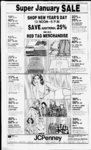
| OCR Text |
Show DAVIS COUNTY CUPPER, DECEMBER 29, 1982 South 22 degs. 48' 00" East 76.70 ft; th N 67 degs. 56' 39" E 1.51 ft to SE cor of said Lot 2, th N 22 degs. 48' 00 W 76.02 feet; thence N 40 degs. 57' 21" West 36.46 feet to th POB. Corn. .004 ' Acres. Total Tax $3.83 Golden West Development Inc., Beg at NE Cor 11:143:0069, of Lot 4, Grand Oaks Plat A. run th S 25 degs. 48' 52" W 1.63 ft; th S 40 degs. 57' 21" 126.10 ft; th N 49 degs. 02' E 1.50 ft to SE cor of said Lot 4; Sec 35; T4N-R1W- ; SLM Thence N 40 degs. 57 21" W 126.75 ft to POB. Corn. .01 Acre S3. 83 Total Tax Golden West Development Inc., 11:143:0070 Beg at NE Cor of Lot 5, Grand Oaks Plat A. 39" Sec. 35; 1.52 T4N-R1W- run ; degs. 31' 09" W ft; thence South 40 degs. South 57 E 64.73 ft; th N 25 57' 21 degs. 48" 52" E 1.63 ft to SE Cor of said Lot 5; th N 40 degs. 57' 21' W 63.86 ft to the POB. Corn. .001 Acres. S3. 83 Total Tax Golden West Development Inc.. 143:1X172 Beg at NE Cor of Lot 60. Grand Oaks Plat "A", and run th S 88 degs. 44 ft; th S 22 20' 09" W degs. 48 00 East E 116.41 ft: th N 64 degs. 24 39" East 2 14 feet to the SE Cor of said Lot 60. thence N 22 degs. 48 00" West 115.61 ft to the Pi) B Cont .00 Acres. Also: Beg at the NE cor of Lot 3. Grand Oaks, plat "A", and run thence South 49 degs. 02' 39" West 1.50 ft. thence South 40 degs. 27' 21" East 97.06 ft: thence N 53 degs. 47' 39" East 1.51 It to the SE Cor of said Lot 3. Th N 40 degs. 57' 21" W 97.19 ft to the POB. .003 Ac. Also: Beg at the NE Cor of Lot , Grand Oaks, Plat and run th S 67 degs. .81 ft; thence 56' 39" West S 22 degs 48' 00" East 128.0 ft; thence N 88 degs. 19' 00" East 1.94 ft to the SE Cor of said Lot 1; th N 22 degs. 48' "A", 00" W 128.68 feet to the POB. Cont. .005 Acres Beg at the NE Cor of Lot 61, and Grand Oaks. Plat run th South 64 degs. 24' 39" West 2.14 feet; thence S 22 degs. 48' 00" East 44.52 ft: thencce South 22 degs. 22' 47" East 112.62 ft; thence N 48 degs. 48' 10" East 1.92 feet to the SE Cor of said Lot 61, th N 22 degs. 22' 47" West 111.32 ft; thence N 22 degs. 48' 00" West 45.32 ft to the POB. Cont. .006 Acres. Also: Beg at the NE Cor of "A, Lot 52, Grand Oaks, Plat "A", and run th South 88 degs. 19' West 1.94 ft, thence S 22 degs. 48' East 129.69 ft; thence N 88 degs. 20 09" East 1.94 ft to the SE cor of said lot; thence N 22 degs 48' W 129.69 ft to the POB. Cont. .005 Acres Total 0.02 Acres these are pick-up- s from Lots 1, 3, 52, 60. 61 out of and 003, -0052,0061 (was (Was S3. 83 Total Tax : 144:02 10, Jack M. Helgesen, All of Lot 210 Grand Oaks Plat B, Sec 35 and 36: T4N-R1SLM: Cont .24 Acres. $133.32 Total Tax Paradise Builders Inc., All of Lot 220 Grand Oaks Plat B, Sec 35 SLM: and 36; T4N-R1Cont. .23 Acres. $724.06 Total Tax Paradise Builders Inc.. 11:144:-022All of Lot 222 Grand Oaks Plat B. Sec. 35 and 36; SLM: Coni. .23 ; Acres. $881.90 Total Tax 11:144:0227, James L. Lingo. All of Lot 227 Grand Oaks Plat B, Sec 35 and 36: T4N-R1SLM: Cont. .29 Acres. $908.71 Total Tax Golden West Dev. Inc.. 11:144:-022All of Lot 228 Grand Oaks Plat B. Sec 35 and 36; SLM: Cont .5 ; Acres. ' $147.88 Total Tax Keith Spencer Wight. 11:144:-023All of Lot 238 Grand Oaks Plat B. Sec 35 and 36; : SLM: Cont. .31 Acres. $995.29 Total Tax Ben F. Donoho. 11:144:0243. All of Lot 243 Grand Oaks Plat B. Sec 35 and 36; ; SLM: Cont. .26 Acres. Total Tax $1,474.17 Golden West Dev Inc.. 11:144:-025All of Lot 251 Grand Oaks Plat B. Sec 35 and 36; T4N-RI; SLM: Cont .34 Acres. Total Tax $147. Bernard Croft Rollins. 11:144:-0257- , All of Lot 257 Grand Oaks Plat B. Sec 35 and 36: ; SLM: Cont. .40 Acres except the following: Beg at NW Cor of said Lot 256. Grand Oaks. Plat B. and Run thence alg arc of a 60 ft rad cur to left (rad pt bears South 40 degs. 36' 22" W) 10.9' ft; thence North 69 degs. 56' 09" East 113.95 ft: thence S 20 degs. 03' 51" Fast 10 ft: thence South 69 degs. 56' 09" West 109.4'? ft to POB. Cont. .03 Acres Total .37 Acres. Total Tax $781.52 Golden West Dev. Inc.. All of Lot 259 Grand Oaks Plat B. Sec 35 T4N-RIand 36: SLM: Cont. .27 Acres. Total Tax $137.15 Pleasantview Land Company. 1 1: 145:0044. All of West 10 ft of Lot 13. Country Place No. T4N-RIW- : I; Sec 35-3SLM: Cont. .06 Acres. Total Tax $8.43 S. Lee Bumingham, 08:041:-001Beg 842.90 ft East from the NW Cor of Sec 12. T2N-RISLM: Thence South 88 degs. 54' East 201.73 ft: thence South 47 degs. 23' 120 ft: Thence 15" East South 62 degs 11: 20" East 174.12 feet: thence South 51 degs. 12 40" West 286.76 feet: thence North 52 degs. feet: thence . 5L West 320.49 'North 66 degs. 58' 50" West 137.93 feet to the E'ly line of ppty conv to Richard J. White Etux as entry no. 315423; thence NE'ly 189.51 feet along said ppty to the POB. Cont. 2.54 Ac subject to rw and together rw. $1,160.57 Total Tax '. ' KAYSVILLE ABC fcemston-Clai- r ' 11 040:0015. D. Construction. Beg at a pt South 0 degs. 16' 20" West SLM: Cont. .28 Acres. $73.37 Total Tax along sec In 1331.01 feet and South 89 degs. 44' 30" West Jerry P. Larsen, 11:059:0027, 424.22 feet and South 0 degs. Lot 27, Mutton Hollow 26' East 277.06 ft fr NE cor '; Meadows; Sec 27, T4N-R1SLM: Sec 26; SLM: Cont. .28 Acres. Run thence South 0 deg 26' $73.37 Total Tax East 66.87 ft along the W line Reese J. Roberts. 11:059:0029. of King Clarion Hills No. 11; Lot 29, Mutton Hollow Thence South 24 degs. 23' Sec. 27. T4N-R1Meadows, 32" W 142.29 feet to the E'ly SLM: Cont. .23 Acres. line of King Clarion Hills No. $71.10 Total Tax 8; thence North 16 degs. 31' Reese J. Roberts, 11:059:0030, E 204.91 feet along said E'ly Lot 30. Mutton Hollow line to the POB. Cont. .075 Sec. 27, T4N-R1Meadows. Acres. SLM: Cont. .28 Acres. Total Tax $12.86 Total Tax $73.37 Shirley F. Jacobsen, 11:040:-003Reese J. Roberts. 11:059:0031, SW of a at cor the Beg Lot 31, Mutton Hollow Lot 601 King Clarion Hills Sec. 27, T4N-R1Meadows, Sub No. 6. a sub of pt of Sec SLM: Cont. .28 Acres. : SLM. and rn 26. Total Tax $73.37 thence North 20 degs. W Reese J. Roberts. 11:059:0033. 125.87 ft; ihence North 66 Lot 33, Mutton Hollow degs. 04' West 86.48 feet; Meadows. Sec. 27. T4N-R1thence South 70 degs. West SLM: Cont. .28 Acres. 22.72 feet; thence South 20 Total Tax $73.37 degs. East 2.50 feet; thence Reese J. Roberts, 11:059:0035, W'ly 125.53 feet aaong the Lot 35. Mutton Hollow arc of a 1027.50 feet rad Sec. 27. T4N-RIMeadows. curve to the left to pt of a SLM: Cont. .28 Acres. 937.70 feet rad cur to the Total Tax $73.37 right; thence W'ly 125.47 feet Reese J. Roberts, 11:059:0036, the said curve: arc of along Lot 36, Mutton Hollow thence South 70 degs. 40' Sec. 27, T4N-R1Meadows, West 516.58 feet to point of SLM: Cont. .28 Acres. curve of a 602.05 feet rad $73.37 Total Tax curve to the right: thence 11:059:0037. Reese J. Roberts. W 'ly 52.54 feet along the arc Lot 37. Mutton Hollow of said cur: th N 14 degs. 20' Sec. 27. T4N-R1Meadows. West 99.67 ft.; th S 78 degs. SLM: Cont. .28 Acres. West 176.32 feet: thence S 72 Total Tax $73.37 degs West 92.45 feet; thence South 81 degs. 14' 30" West 10.08 feet; thence South 26 KAYSVILLE degs East 106.17 feet; thence ABH South 64 degs. W 15 feet to the SE Cor of Lot 1309 King First Sec. Bank Of Utah. NA, Clarion Hills No 13. ihence 07:098:0004, All of Lot 4, Sec. 2. South 26 degs. 170.85 feet to T3N-R1SLM: Alta Acres. NE Cor of Lot 530 KCH No. Cont. .23 Acres. 5 Sub; thence North 73 degs. Total Tax $113.23 East 378.75 feet: thence First Sec. Bank Of Utah, NA, North 70 degs. 40' Fast 07:098:0005, All of Lot 5, Sec. 2, 768.11 feet; thence North 70 T3N-RISLM: Alta Acres. feet the East 11.40 to degs. Cont. .23 Acres. POB. Cont. 7.8165 Acres. Total Tax $113.23 Total Tax $540.83 First Sec. Bank Of Utah. NA, Arthur C. Carlson. 111. 11:046:-05107:098:0006. All of Lot 6, Sec. 2, Lot 514. King Clarion T3N-RISLM: Alta Acres. Hills No. 5. Sec 26 T4N-RICont. .23 Acres. .257 Acre. SLM. Cont. Total Tax $113.23 $689.08 Total Tax First Sec. Bank Of Utah, NA. Gary L. McBride. 11:046:0527. 07:098:0007. All of Lot 7, Sec. 2, Lot 527. King Clarion Hills T3N-R1SLM: Alta Acres. No. 5. Sec. 26 T4N-R1Cont. .23 Acres. SLM, Cont. .25 Acre. Total Tax $113.23 $645.21 Total Tax Richard Charles Easton, Charles G. Bacon, 11:047:0612, 07:098:0010, All of Lot 10, Sec All of Lot 612, King Clarion 2, T3N-R1SLM; Alta Hills No. 6 Sec. 26; T4N-R1Acres. Cont. .23 Acres. SLM: Cont. .35 Acres. Total Tax $113.12 $244.17 Total Tax First Sec. Bank Of Utah, NA, Wayne F. Palmer, 11:048:-08107:098:0011, All of Lot 11, Sec. All of Lot 817. King SLM: Alta 2, T3N-RIClarion Hills No. 8, Sec 26; Acres. Cont. .23 Acres. T4N-R1SLm: Cont. .319 Total Tax $113.23 Acres. First Sec. Bank Of Utah, NA, $858.51 Total Tax 07:098:0012, All of Lot 12, Sec. Shirley F. Jacobsen. 11:048:-100SLM: Alta 2, T3N-R1All of Lot 1003, King Acres. Cont. .23 Acres. Clarion Hills No. 1. Sec 26; $113.23 Total Tax T4N-R1SLM: Cont. .23 First Sec. Bank Of Utah, NA, Acres. 07:098:0013, All of Lot 13, Sec. $112.70 Total Tax SLM: Alta 2, T3N-R111:048:F. Jacobsen, Shirley Acres. Cont. .23 Acres. 1018, All of Lot 1018, King Total Tax $113.23 Clarion Hills No. 1. Sec 26; J. Brunnette. Douglas SLM: Cont. .29 ; 07:098:0014, All of Lot 14. Sec Acres. 2, T3N-R1SLM; Alta $118.75 Total Tax Acres. Cont. .23 Acres. 11:048:F. Jacobsen, Shirley $1 13.12 Total Tax 1019, All of Lot 1019, King First Sec. Bank Of Utah, NA, 1. Sec No. Clarion Hills 26; 07:098:0015, All of Lot 15, Sec. SLM: Cont. .26 ; SLM: Alta 2, T3N-R1Acres. Acres. Cont. .23 Acres. $115.73 Total Tax Total Tax $113.23 1:048:1024. John W. Teeslink. Sec. Bank Of Utah, NA, First Beg at NE Cor of said Lot All Lot of 16, Sec. 07:098:0016, 1023; King Clarion Hills No. T3N-R1SLM: Alta 2, 10; South 0 degs. 26' East 20 Acres. Cont. .23 Acres. ft; thence South 74 degs. 34' Total Tax $113.23 West 217.3 ft to NW Cor of Rick L. Luckert, 07:100:0017, said lot; North 69 degs. 36' All of Lot 17, Gailey Plat A, East 223.32 ft to POB. Cont T3N-R13 SLM: Sec .05 Acres. Cont. .261 Acres. $5.29 Total Tax $664.91 Total Tax Shirley F. Jacobsen, 11:048:-110L. Doreen Foster, 07:106:0017, Lot 1103, Sec. 25, 26, Beg at SW Cor of Lot 1, T4N-R1SLM; King ClarFoster-Heat1: h 2; Sec 2, ion Hills No. 11, Cont. .23 T3N-R1SLM: Thence Acres. Ely 5.45 ft along cur to right $89.70 Total Tax along Nly line of st thence Shirlev F. Jacobsen. 11:048:- approx N 27 degs 48 East 1106, Lot 1106. Sec. 25. 26, 187.4 feet to N'ly line said T4N-R1SLM: King ClarLot 1; thence W 23.91 ft to ion Hills No. 11. Cont. .27 NW corner said Lot 1; Acres. thence South 22 degs. 18' $115.73 Total Tax 30" West 123.39 feet to POB. 11:048:F. Jacobsen, Shirley Cont. .04 Acres. 1107, Lot 1107. Sec. 25, 26, $3.80 Total Tax T4N-R1ClarSLM; King Jack Evans, 07:109:0013, All of ion Hills No. 11, Cont. .30 Lot 13 Upland. Sec 2; T3N-R1Acres. SLM: Cont. .380 $118.00 Tax Total Acres. 11:048:Shirley F. Jacobsen. $882.24 Total Tax 1201. Lot 1201. King Clarion Eldon V. Haacke, 07:1090022, Hills No. 12: Sec. 25, 26. 22 All of Lot Upland, Sec 2; T4N. R1W: SLM Cont. .27 T3N-R1W- ; SLM: Cont. .42 Acre. Acres. $21.94 Total Tax $964.31 Total Tax Shirley F. Jacobsen, 11:048:- Harry G. Duckworth, 08:002:-0031202. Lot 1202. King Clarion South 14 of Lots 5 and Hills No. 12: Sec. 25. 26. Blk 4, Plat C, Kays Ts 6, T4N, R1W; SLM Cont. .26 Sur; Cont. .40 Acres. Acre. $408.07 Total Tax $21.18 Total Tax Steven J. Anderson, 08:002:-006Higlev Fairbourn Inc.. 11:048:- Beg South 88 degs. 11 1203. All of Lot 1203. King ft North 19 East 1509.65 Clarion Hills No. 12. Sec. 25. degs. 32' West 804.07 ft N 88 : SLM: Cont. 26. degs. 40' 45" East 1492.72 .27 Acres. feet N 3 degs. 45' East 87.1 $21.94 Total Tax feet fr SW cor of NW cor od 11:048:-120F. Jacobsen, Shirley Sec SLM, said pt Lot 1208, King Clarion being cen of rd th N 3 degs Hills No. 12: Sec. 25, 26. 45' E 100 ft thence South 85 T4N. RIW; SLM Cont. .40 degs. 53' East 180.41 feet th Acre. South 3 degs. 45 W 100 ft $31.01 Total Tax thence N 85 degs. 53' West 11:049:-130Shirlev F. Jacobsen. 180.41 feet to POB. Cont. .48 All of Lot 1301, King or out of KA-41- 9 Acres Clarion Hills No. 13: Sec. 25. 26. T4N. RIW; SLM Cont. $468.10 Total Tax .248 Acre. Henry L. Carter, 08:007:0037, $114.22 Total Tax All of Lot 37, Gailey Plat C. Reese J. Roberts. 11:059:0001, SLM: Sec 3; T3N-R1Lot 1, Mutton Hollow Cont. .21 Acres. Sec. 27. T4N-RIMeadows, $660.35 Total Tax SLM: Cont. .30 Acres. $75.64 Total Tax Clay P. Bake, 08:030:0069, Beg Reese J. Roberts. 11:059:0003, at a pt on bndy In of said Lot Hollow 3. Mutton Lot 72, Palso Verdes Estates, T4N-RIW- '; 27. Meadows. Sec. Plat C. being in .23 Acres. SLM: Cont. SLM. which is 38 degs. $35.55 Total Tax 53' 08" West 30.14 ft fr the E Reese J. Roberts. 11:059:0012. cor of said Lot, and run Lot 12, Mutton Hollow thence 6.99 feet along the arc T4N-R1Meadows. Sec. 27, of a 615.86 foot rad cur to the SLM: Cont. .27 Acres. left through a central angle of $73.37 Total Tax 0 deg. 39' (chord bears South Reese J. Roberts, 11:059:0013, 37 degs. 09' 30"); thence N Lot 13, Mutton Hollow 52 degs. 49' West 36.86 ft; Meadows. Sec. 27, T4N-RIthence N 37 degs. IF East SLM: Cont. .31 Acres. 7.0 ft; thence South 52 degs. $75.64 Total Tax 49" East 36.85 feet to the Reese J. Roberts. 11:059:0014, POB. Cont. .006 Acres. Lot 14. Mutton Hollow Total Tax $3.80 T4N-RISec. 27. Meadows. Gregorv Thomas Layton. SLM: Cont. .23 Acres. All of Lot 85, Palos $71.10 Total Tax Verdes Est. Plat D, Sec 10, T3N-R1Reese J. Roberts, 11:059:0015, SLM: Cont .19 Lot 15, Mutton Hollow Acres. Sec. 27, T4N-RIMeadows. Total Tax $555.49 SLM: Cont. .23 Acres. Brad L. Holbrook, 08:091:0017, $71.10 Total Tax All of Lot 17, Green View SLM: Sub; Sec 3. T3N-R1Faerber Constr Co.. 11:059:-002Cont. .185 Acres. Lot 20, Mutton Hollow $373.87 Total Tax Meadows; Sec 27, T4N-RIW- '; Douglas C. Larsen. 08:091:-002SLM: Cont. .27 Acres. All of Lot 24, Green $91.90 Total Tax View Sub: No. 2 Sec 3, T3N-R1Jerry P. Larsen. 11:059:0026. SLM: Cont. .19 Acres. Lot 26, Mutton Hollow $425.54 Total Tax Meadows: Sec 27. T4N-R1W- ; PAGE TEN Alan W. Roundy, 08:092:0016, Lot 16, Happy Homes Sub Blk 19, Plat G, Kays Ts, Cont. .228 Acres. Total Tax $370.83 Van W. Flint, 11:096:007, Beg at a pt which is South 57 degs. 33 13" West 409.85 ft to E'ly rw In of st hy and North 43 degs. 06 13 East 95 feet fr NE comer of Sec SLM: and run 33, T4N-R1th N 43 degs. 06 13" East 116 feet; thence North 47 degs. 45 47 West 142.6 ft, M or L, to S In of a Lane; thence South 41 degs. 16 13" W 116 ft along South of said lane; thence South 47 degs. 45 47" East 138.889 ft, M or L, to POB. Cont. .375 Acres. Total Tax $344.23 Sheryl E. Anderson, 11:098:-000South 0 Beg at a pt degs. 54' 50" West 918.52 ft along Sec line fr E 14 cor of Sec 33, T4N-R1SLM: Thence East 14.65 feet to West line of a st: thence South 0 deg. 49 West 148 feet along said st; thence South 85 degs. 40 W 75.89 feet; thence North 23 degs. 45' West 167.94 feet; thence East 130.77 fee, to POB. Cont. .375. $560.05 Total Tax Frank D. Bums, 11:098 0018, Beg on W line of st 1727.9 ft N fr SE cor Sec 33, T4N-R1SLM. North 75 feet North 88 degs. 36 West 401.0 feet to ditch desc in Book D Page 230 of deeds, at pt 50 ft Ely fr cen In of OS1 RR rw; South 25 degs. 10 East .64 chs, North 64 degs. 50' East 1.58 chains; South 25 degs. 10 East 2.42 chains. North 37 degs. 42 East 1.73 chains South 23 degs. 45 East 8.9 feet thence E 145.42 ft to Beg. Cont. .635 Acre. $253.05 Total Tax Jitney Inc., 11:099:0001, All of Lot I, Marketboro, Sec 33 SLM: and 34; T4N-R1Cont. 1.73 Acres. $561.57 Total Tax David M. Faerber, 11:099:0003, All of Lot 3, Marketboro, ; Sec 33 and 34; SLM: Cont .56 Acres. Total Tax $2,019.05 Jay R. Yates, 11:099:0004, All of Lot 4. Marketboro, Sec 33 SLM: and 34; T4N-R1Cont. .57 Acres. Total Tax $98.79 Charles R. Schumaker, 11:099:- 0020, All of Lot 20, Marketboro. Sec 33 and 34; T4N-R1SLM: Cont. 1.01 Acres. $34. Total Tax Charles R. Schumaker, 11:099:- 0021, All of Lot 21, Market boro. Sec 33 and 34; T4N-R1SLM: Cont. .56 Acres. Total Tax $19.00 Jitney Inc., 11:099:0022, All of Lot 22, Marketboro, Sec 33 SLM: and 34; T4N-R1Cont. .89 Acres. Total Tax $31.16 Jitney Inc., 11:099:0023. All of Lot 23, Marketboro. Sec 33 SLM: and 34; T4N-R1Cont. .96 Acres. Total Tax $33.44 Marketboro Dev Co., 11:099:- 0034, All of Lot 34, Market boro, Sec 33 and 34; T4N-R1SLM: Cont. .63 Acres. $109.43 Total Tax Marketboro Dev Co., 11:099:- 0035, All of Lot 35, Market ; boro, Sec 33 and 34; SLM: Cont. .69 Acres. $120.06 Total Tax Corp., Episcopal Management 11:100:0045, Beg at a pt wh is N 46 Degs. 25 W 703.50 ft and N 75 degs. 10 W 249.27 ft and North 43 degs. 35' East 459.96 ft fr SW cor of Blk 17, Plat D, Kays Ts Sur; SLM: Sec 34; T4N-R1Run thence N 43 degs. 14' W 711.56 ft; thence N 46 degs. 46 East 260 ft; thence S 43 degs. 14 East 697.02 feet; thence South 43 degs 35 West 260.41 feet M or L to POB. Cont. 4.20 Acres. Total Tax $17,243.65 Richard W. Barton, 11:100:0049, Beg at pt wh is N 46 degs. 25 W 650 ft and N 43 degs. 35 E 125 ft fr SW cor of Blk 17, Plat D, Kays Ts Sur; N 46 degs. 25 W 272.04 ft: N 43 degs. 35' East 160.12 ft; East South 46 degs. 25 272.04 feet; South 43 degs. 35 W 160.12 feet to POB. 1.00 Acres. $86.63 Total Tax David B. Stayner, 11:100:0050, Beg at a pt which is N 46 degs. 25 West 650 ft and N 43 degs. 35 East 285.12 feet from SW Cor of Blk 17, Plat D, Kavs Ts Sur; North 46 degs. 25 W 272.48 feet North 43 degs. 35 East 319.98 ft M or L to W rw In of BBRR: South 43 degs. 14' East along said rw 272.48 ft M or L to a pt N 43 degs. 35 East of beg; South 43 degs. 35 West 298.88 ft M or L to POB. Cont 2.03 Acres. $2,171.79 Total Tax Lloyd N. Hayes, 11:100:0082, Beg on Wly line of a str at a pt N 46 degs. 25 W 703.5 feet and N 75 degs. 10 West 745.57 feet along NEly line of a hyw and North 14 degs 12 East 329.10 feet and N 28 degs. 10 East 146.13 feet and South 61 degrees 50 East 1.0 feet and NTy 163.84 feet along arc of a 371.36 ft rad cur to left and N'ly 36.16 feet along arc of a 315.51 ft rad cur to right fr SW cor of Blk 17, Plat D Kays Ts Sur; thence 70 degs. 39' 50" West 305.94 feet; thence N 0 degs. 30 East 100.85 feet; thence North 43 degs. 55' East 217.44 feet; thence North 71 degs. 02 East 238.7 feet: thence South 43 degs. 14' East 7.9 feet; thence South 62 degs. 01 East 105.6 feet; thence South 43 degs. 14' East 113 feet to W'ly line of a street; South 46 degs. 46' West 207.91 feet; thence S ly 205.46 feet along arc of a 315.51 feet rad cur to left (rad pt bear South 43 degs. 14' East) to POB. Cont. 3.05 Ac. $424.02 Total Tax Fairfield Farm Property Owners. 11:101:0001, Beg at NW Cor of Lot 2 Fairfield Farm Est No. 1 sd pt being S 252.46 ft and W 1911.65 ft fr NE cor SLM: of Sec 34; T4N-R1Thence South 45 degs. West 26.69 feet to a pt on a 1105.92 feet rad cur (said pt is on E'ly line of Fairfield Rd) thence along said E'ly In 6.206 ft thence N 8 degs. 49' 56 East 16.11 ft along E In to S In of Holmes Creek Dr th N 45 degs. East 30.28 feet thence East 153.26 feet thence Sly 122.17 feet along arc of a 100 ft rad cur to right th N 54 degs. 30 W 89.66 feet thence South 86 degs 26 West 173.67 ft to POB Cont. .116 Acres. Total Tax $12.16 Davis Farm Coop, 11:101:0023, Beg on E side of hy 91 at pt 280 ft N 46 degs. 25 W fr SW cor Blk 17, Plat D. Kays Ts Sur; thence N 58 degs. 15 E 309 ft; thence South 31 degs 45' East 18.8 feet; thence N 58 degs 15 East 252 ft; thence North 20 degs. 09' East 45.02 feet to W line of rw of Old Berr; Thence N 43 degs. 14 West 470.6 ft; th South 43 degs. 35' West 582 ft, m or 1, to E line of Hy 91 ; thence South 46 degs. 25 East 370 ft to POB. Cont. Also beg at pt 280 ft N 46 degs. 25 W fr SW cor Blk 17, Plat D; thence N 58 degs. 15 East 309 ft; thence South 31 degs. 45 East 18.8 feet thence South 61 degs. 55 West 307.8 feet to POB. Cont. 5.69 Acres together with RW. Total Tax $1,761.45 Jetta B. Fillin, 11:101:0026 Beg on N'ly line of a cert st at E'ly In of Berr rw, N 67 degs. 00' East 237.1 feet fr SW cor of Blk 16, Plat D. Kays Ts Sur; Th N 67 degs. 00' East along N'ly In of sd st, 100 ft; thence N 16 degs. 46' 50" West 181.6 feet; thence S 74 degs. 18 W 46.60 feet; thence South 20 degs. 27' East 17.25 ft: thence S 67 degs. 26 W 109 feet to Ely line of a road; thence South 34 degs. 10' 30" East 194.86 feet, M or L to Pob. Cont. .42 Acres. Total Tax $70.67 Donald E. Schomburg, 11:102:-004Beg at pt 128 ft South of NW Cor of Lot 5, Blk 15, Plat A, Kays Ts, S 64 ft, East 256.35 ft M or L to E line of Lot 6, N 64 feet, West 256.35 feet to Beg. Cont. .376 Acre. Total Tax $301.68 11:103:- Sheldon L. Rueckert. 0021, Lot 4, Blk 32, Plat A, Kays to Sur. Cont .76 Acres. Total Tax $209.73 Roger Christensen, 11:104:0011, Beg at SW Cor Blk 31, Plat A, Kays Ts, N 107 ft, E 72 ft, South 107 ft, th W 72 ft to Beg. Cont. .20 Acre. Total Tax $234.05 William B. Cook, 11:104:0041, E 12 of Lot 3, Blk 29, Plat A, Kays Ts Sur. Cont .40 Acres. Total Tax $519.77 John B. Gailey, 11:105:0007, Beg SE Cor Lot 4, Blk 28, Plat A, Kays Ts, North 129.4 feet. W 75.5 ft, S 129.4 ft, East 75.5 feet to Beg. Cont. .23 Acres. Total Tax $258.37 Jerry P. Larsen, 11:105:0019, Beg on the N In of a st at a pt 66 ft W of the SE cor of Lot 1, Blk 28, Plat A, Kays Ts Sur; thence N 136.19 feet, thence W 15 ft, thence N 106.21 ft to a pt 15 ft South of the N line of said Lot 1; thence W 105 ft, th S 242.4 ft to the N In of a st; thence E 120 ft along said st to the POB. Cont. .504 Acres. Total Tax $221.89 Wallace F. Allen, 11:105:0020, Beg 136.19 ft North fr the SE Cor of Lot 1, Blk 28, Plat A, Kays Ts Sur: North 106.21 ft to a pt 15 ft South of the NE Cor of said lot; thence W 81 ft; thence S 106.21 ft; thence E 81 ft to the POB. COnt. .20 Acres. Total Tax $95.75 William H. Starkweather, Beg at pt 88 feet East of NW cor of Lot 7 Blk 27, Plat A; Kays to Sur; East 88 ft, South 132 ft, West 88 ft, North 132 ft to beg. Cont. .26 Acres. Total Tax $122.22 Bernard W. Mitchell, 11:105:- 0028, South 12 of Lots 5 and 6, Blk 27, Plat A. Kays to Sur; Cont. .78 Acres. Total Tax $366.27 Bernard W. Mitchell, 11:105:-003Beg at a pt on E line of a st N 0 deg. 31 33 East 204.4 feet aaong city sur mon In and South 89 degs. 30 East 49.5 feet from city sur at inter of cen line of 100 N Street and 300 East St; thence North 0 degs. 31 33 East 86 ft aaong said st to NW cor Lot 4, Blk 27. Plat A. Kays Ts Sur; thence South 89 degs. 30 East 200 ft; thence South 0 deg. 31 33" West 86 feet thence North 89 degs. 30 West 200 ft to POB. Cont. .39 Acres. Total Tax $123.10 Parley H. J. Timothy, 11:105:-007Beg N cor of Lot 7, Blk 22, Plat A; Kays Ts Sur; West 66 ft, South 257.4 feet, East 6 ft, North 257.4 feet to beg. Cont. .39 Acres. Total Tax $429.34 Wallace F. Allen, 11:105:0077, Beg NW cor Lot 4, Blk 22, Plat A, Kays Ts, East 198 ft, South 66 ft, West 198 ft, North 66 ft to Beg. Cont. .30 Acres. Total Tax $623.88 Wallace F. Allen, 11:105:0077, Beg NW cor Lot 4, Blk 22, Plat A, Kays Ts, East 198 ft. South 66 ft. West 198 ft, North 66 ft to Beg. Cont. .30 Acres. Total Tax Wallace F. $97.27 Allen, 11:105:-007- Beg 105.4 feet North fr SW cor Lot 4, Blk 22 Plat A, Kays Ts thence North 86 ft. East 132 ft. South 86 ft, thence W 132 ft to Beg. Cont. Total Tax $97.27 Duane R. Jackson, 11:105:0086, Beg at a pt 66 ft West and 142.4 feet South of the NE Cor of Lot 8, Blk 22, Plat A, Kays Ts Sur; and Sur; and run thence S 199 ft to a pt 66 ft West and 173.4 feet North of the Sec Cor of Lot 1, said Blk 22; thence W 66 ft to the West line of said Lot 1; thence North 199 ft; thence Eat 66 ft to the POB. Cont. .30 Acres. $20.52 Total Tax Bruce A. Yates, 11:106:0045, Beg on South line of 1st South st at a pt South 0 deg. 42 West 33 ft and North 89 degs. 31 West 133.9 feet along South line said st fr City Monu at Center of Intersec of 1st South st and Third West St; thence South 1 deg. 50' East 79.53 feet to NW cor of ppty conv in 764-26thence N 89 degs. 31 East 103.5 feet to W line of str; thence N 77.44 feet aaong West line said st to South line of 1st S st; thence North 89 degs. 31 West 106.01 feet along South line said st to the POB. Cont. .185 Acres. $458.22 Total Tax Jack P. Silotti, 11:107:0023, Beg 161 ft South of NE Cor Lot 5, Blk 8, Plat A, Kays Ts; thence South 103 ft; West 85.8 ft; North 103 ft; thence E 85.8 feet to Beg. Cont. .20 Acres. $21.28 Total Tax Jack Paul Silotti, 11:107:0027, Beg. 153 ft West fr NE Cor Lot 6, Blk 8, Plat A, Kays Ts, South 198 ft, West 104.4 feet, North 198 ft, Eat 104.4 feet to Beg. Cont. .474 Acres. $565.37 Total Tax Diane G. Green, 11:108:0002, Beg 77 ft East of N'W Cor of Blk 7, Plat A Kays Ts, South 112 ft, East 55 ft, West 55 ft to Beg. Cont. .141 Acres. $256.85 Total Tax 76 Enterprises, 11:108:0003, N 12 of Lot 4, Blk 7, Plat A, Kays Ts Sur; Cont. .40 Acres. $1,652.02 Total Tax 11:108:0005, 76 Enterprises, Beg at SE Cor Lot 4, Blk 7, Plat A, Kays. Ts, thence North 132 ft. West 125 ft. South 132 ft. East 125 ft to Beg. Cont. .38 Acres. $287.24 Total Tax 11:108:0008, 76 Enterprises, Beg a NE Cor Lot 2, BLk 7, Plat A. Kays Ts, thence West 100 ft, thence South 132 ft to South line of Lot 2; thence East 89 ft; thence NE'ly 45 ft to E line of Lot 2; thence N Cont. .297 89 ft to POB. Acres. $227.21 Total Tax Hugh Barnes, 11:108:0028, Beg NW Cor of Lot 6, Blk 5, Plat A, Kays to Sur; East 66 ft, South 132 ft, W 66 ft, N 132 ft to Beg. Cont. .20 Acres. $82.08 Total Tax Modesto Efrem Ruuybal, 11:108: 0034, Lot 8, Blk 5, Plat A. Kays Ts Sur. Cont .80 Acres. $396.67 Total Tax Geraldine Thompson, 11:108:-006Beg on E line of a st 106 ft South of NW Cor Lot 4, Blk 7, Plat C, Kays Ts; thence East 9 ft, M or L, to E line of Old Berr rw; thence Nly along E line said rw to E line said st; South 43 ft to Beg. Cont. .002 Acres. $3.80 Total Tax Frances S. Mary Bagley, The N 12 of Lot 8, Blk 4, Plat A Kays Ts, Cont. .40 Acre. Total Tax $298.64 Jay Done Thomley, 11:109:0035, Beg 55 ft South ONE Cor of South 12 of Lot 8, Blk 8, Plat C, Kays Ts, South 77 ft, West 264 ft. North 77 ft; East 264 ft to Beg. Cont. Total Tax $563.09 Rozella M. Burton, 11:209:0063, All of Lot 2 Blk 9, Plat C, Kaysville Townsite Survey, Cont. .80 Acres. Total Tax $502.29 N. Dale Sargent, 11:112:0030, Beg 64.35 ft North of SE Cor of Lot 4, Blk 25, Plat A, Kays Ts Sur and run th N 64.35 ft; thence W 145 ft to E line of a street thence South 64.35 t aaong said st; thence East 145 ft to POB. Cont. .214 Acres. Total Tax $281.16 Wallace F. Allen, 11:112:0048, 13 ft W fr NW Cor Lot Beg 4, Blk 23, Plat A, Kays. Ts. South 90 ft; Sur; thence thence East 99 ft; thence N 90 ft; thence W 99 ft to POB. Cont. .205 Acres. Total Tax $95.75 B. W. Mitchell, 11:112:0058, Beg at NE Cor Lot 6, Blk 24, Plat A, Kays Ts; thence W 68.5 feet along South line of a st South 120.5 feet; East 68.5 feet; thence N 120.5 feet to beg, Cont. .195 Acres. Total Tax $474.94 Benjamin Bramwell, 11:133:0013, Beg on the N of a str N 89 degs. 29' 20" West 3.0 feet fr the SE Cor of Lot 8, Barker Subd; a part of Sec SLM: and run thence North 89 degs. 29 20" West 90 ft along said str; thence N 0 deg. 30 40 East 110 ft; thence South 89 degs. 29 20 East 90 ft; thence South 9 degs. 30 40 West 110 ft to the POB. Cont. 0.23 Acres out of Total Tax $332.08 Union Investments Inc., 11:114:-002Beg 35.5 ft Eat of SW Cor Ot 3, Blk 1, Plat A, Kays Ts, East 96.5 ft, N 198 ft W .5 feet, South 198 ft to Beg. Cont. .437 Acre. Total Tax $434.66 Melvin M. Taylor, 11:114:0078, Beg at pt East 1 19 feet fr SW cor of Lot 4, Blk 11, Plat C, Kays Ts Sur; North 132 ft, W 132 ft, South 132 ft. Eat 132 ft to Beg. Cont. .40 Acres. Total Tax $224.17 Gary R. Porter, 11:115:0079, Beg at a pt North 66 degs. 10 E 556.5 ft and North 23 degs. 50 West 90 ft along East line of St fr SE Cor of Blk 12, Plat E, Kays. Ts N 23 degs 50 West 85 ft aaong E line said st. North 66 degs. 10 East 206.6 feet m or L to canal rw, South 24 degs. 25' East along said rw to a point North 66 degs. 10 East of Beg, South 66 degs. 10 West 207.16 ft to Beg. Cont. .405 Acres. Total Tax $623.12 Golden West Dev. Inc., 11:115:-009Beg 572.1 ft N 66 degs. 10 East fr SW comer Blk 13, Plat E, Kays Ts, North 66 degs. 10 E 235.74 ft N 118.8 ft to N In Blk 13, South 60 degs. 23 W 345.07 ft to E line canal, So 24 degs. 45' East 57.8 feet to Beg. Cont. .68 Acres. $47.11 Total Tax Ernest J. Davenport, All of Lot 1, Twin Creeks Estates Sec SLM: Cont. 35; T4N-R1.520 Acres. Total Tax $131.45 Vellis (Gae) Pincock, All of Lot 6, Twin Creeks Estates Sec 35; T4N-R1SLM: Cont, 1.165 Acres except: Beg at South Cor Common to Lot 6 and 7, Twin Creeks Est. and run thence North 2 degs. 00 West 146 ft; thence South 18 West 156.215 degs. 13 19 ft; thence North 87 degs. 221 East 54 feet to POB. 40 Cont. Less .09 Ac Balance 1 .075 Acres. Total Tax $1,059.30 Jerry P. Larsen, 11:135:0005, All of Lot 5, Clover Estates, T4N-R1Sec. 34-3SLM: Cont. .303 Acres. $1,103.37 Total Tax Ronald Pearson, 11:135:0017, All of Lot 17, Clover Estates. Sec T4N-RI- 34-3- SLM: Cont. .228 Acres. $756.10 Total Tax 11:135:-020Ronald V. Harward, All of Lot 209, Clover Kl T2 Acres. $683.91 11:149:0033, All of Lot 33. Hob Hill No. SLM: 2, Sec. 35; T4N-R1Cont. .39 Acres. $172.50 Total Tax H. C. Burton, 11:149:0034, All of Lot 34, Hob Hill No. SLM: 2, Sec. 35; T4N-R1Cont. .37 Acres. $168.70 Total Tax H. C. Burton, 11:149:0039, All of Lot 39, Hob Hill No. SLM: 2, Sec. 35; T4N-R1Cont. .25 Acres. $148.18 Total Tax H. C. Burton. 11:149:0041. All of Lot 41. Hob Hill No. SLM: 2, Sec. 35; T4N-R1Cont. .29 Acres. $155.02 Total Tax John L. Brough. 11:149:0043. AA11 of Lot 43. Hob Hill No. SLM: 2, Sec. 35; T4N-R1Cont. .28 Acres. SI 52. 74 Total Tax H C. Burton. 11:149:0048. All of Lot 48. Hob Hill No. SLM: 2, Sec. 35: T4N-RICont. .32 Acres. $160.34 Total Tax John L. Brough. 11:149:0043. All of Lot 43, Hob Hill No. SLM: 2, Sec. 35: T4N-R1Cont. .28 Acres. $152.74 Total Tax H. C. Burton. 11:149:0048. t Alt U.,U U.ll V., Total Tax H. C. Burton, Cont. .32 Acres. $160.34 Total Tax 1:149:0050. H. C. Burton. All of Lot 50. Hob Hill No. SLM: 2, Sec. 35: T4N-R1Cont. .28 Acres. $152.74 Total Tax H. C. Burton, 11:149:0056, All of Lot 56, Hob Hill No. SLM: 2. Sec. 35: T4N-R1Cont. .41 Acres. $175.54 Total Tax H. C. Burton. 11:149:0059, All of Lot 59. Hob Hill No. SLM: ; 2, Sec. 35; Cont. .29 Acres. $155.02 Total Tax John L. Brough, 11:149:0073, All of Lot 73, Hob Hill No. SLM: 2, Sec. 35: T4N-R1Cont. .28 Acres. Total Tax $1,033.46 1:150:0003: Charles R. Harrell. All of Lot 3, Fairfield Farm Est No. 2 Sec 26. 27. 34. 35: T4N-R1SLM: Cont. .212 Acres. Total Tax $651.23 Richard C. Mouritsen, 11:150:-004All of Lot 40, Fairfield Farm Est No. 2, Sec 26. 27, SLM; 34, 35; T4N-R1Cont. .519 Acres. Total Tax $791.82 John S. Saville. 11:150:0043, All of Lot 43. Fairfield Farm Est No. 2 A Sec 26, 27, 34, SLM; Cont. 35; T4N-R1.24 Acres. Total Tax $113.23 Millcreek Estates, 11:154:0010, Beg at SW Cor of Lot 4, Millcreek Estates Sub; Sec SLM: Run 34; T4N-R1thence N deg 00 22 West 203.74 feet: thence South 8 degs. 04 02" East 203.9 feet to SW Cor of Lot 4, Millcreek Estates No. 2: thence South 85 degs. 49 40 West 25.1 feet to POB. Cont. .059 Acres. Total Tax $6.08 Stanley D. Moss, 11:158:0014, All of Lot 14, Cresthomes Add, situated in Sec 34, TP4N, RG1W, SLM. Cont. .216 Acres. Total Tax $421.74 Robert W. Schmidt, 11:158:0028, Lot 28, Cresthomes Add. No. 2 Sec 34, TP4N, RG1W. SLM, Cont. .233 Acres. Total Tax $271.59 Jan D. Henderson. 11:176.0002, All of Lot 2 Vantage Park SLM. Sec 33, T4N-RICont. .58 Acres. Total Tax $101.07 Jan D. Henderson, 11:176 0003, All of Lot 3 Vantage Park SLM. Sec 33, T4N-R1Cont. .60 Acres out of Total Tax $104.11 Jan D. Henderson, 11:176.0004, 4 All of Lot Vantage Park Sec 33, T4N-R1SLM. Cont. .77 Acres out of Total Tax $2,829.87 Jan D. Henderson, 11:176.0005, All of Lot 5 Vantage Park SLM. Sec 33, T4N-R1Cont. .30 Acres out of Total Tax $52.43 Jan D. Henderson, 11:176.0006, All of Lot 6 Vantage Park Sec 33, T4N-R1SLM. R Cont. .50 Acres out of Total Tax $86.63 Jan D. Henderson, 11:176.0007, All of Lot 7 Vantage Park Sec 33, T4N-R1SLM. Cont. .39 Acres out of KA-49- 7 OR Total Tax $67.63 Jan D. Henderson, 11:176.0008, All of Lot 8 Vantage Park Sec 33, T4N-R1SLM. Cont. .49 Acres out of KA-49- 7 OR Total Tax $85.11 Jan D. Henderson, 11:176.0009, All of Lot 9 Vantage Park Sec 33, T4N-R1SLM. Cont. .28 Acres out of KA-49- 7 OR Total Tax $48.63 Jan D. Henderson, 11:176.0010, All of Lot 10 Vantage Park Sec 33, T4N-R1SLM. Cont. .40 Acres out of KA-49- 7 OR Total Tax $69.91 Marion H. Bennett, Etal., All of Lot Chantilly Square Comm Sub Sec SLM Cont. 33, T4N-R1.68 Acres Out of 177:0005, All of Lot 5 Chantilly Square Comm Sub Sec SLM Cont. 33, T4N-R1.83 Acres $144.38 Total Tax tilly Square Comm Sub Sec SLM Cont. 33, T4N-R1.53 Acres $91.95 Total Tax Marion H. Bennett. Etal.. All of Lot 7 Chan tilly Square Comm Sub Sec SLM Cont. 33. T4N-R1.53 Acres $91.95 Total Tax Marion H. Bennett. Etal.. All of Lot 8 ChanSec-3tilly Square Comm Sub SLM Cont. ; .58 Acres $101.07 Total Tax Security Title Co. of Davis Co.. 08:03 1:0016, Beg on the E In of a platted rd at a pt S 0 degs 00'26" E 348.82 ft along the sec In & N 89 degs 42'40"W 97.47 . ft fr the W '.4 cor of Sec T3N-R1SLM; & run th N I degs 09"50" E 15.82 ft mol. to the S In of 1650 S. str as dedi th S 89 degs cated by 806-4642'40" E 1212 ft to a angle cor of sd st:thN0degs 17'20" E66 ft: th N'ly 309.82 ft along the arc of a 797.08ft rad curve to the left: thN 21 degs '8 53 "W 79.47 ft; th N'ly 7 282 88 ft along the arc of a 737.3.' It rad curve to the right; th N 265 ft: th E 227 ft: th S 123.98 ft th E 32.06 ft: thS 960.50 ft: thN 89 degs 42 '40" W 1322.07ft the pob. Cont. 7.98 acres, less ppty .67 acres remainder in 815-85- 8 7.31 Acres. Total TaxS .130.03 Security Title Co. of Davis Co.. 08:031:0020. Beg on the E In of a platted rd a apt. S 0 degs 00 degs. 26'E 348.82 tl along the sec In & N 89 degs 42'40"W 97.47 ft & N degs 09'50"E 181.82 ft fr the S'A cor of Sec SLM: & run th : 11, N deg09'50"E 239. 18 ft along sd rd: th E 459.29ft ; th N 286.34 ft; th E 417.88 ft: th N 0 degs 04'E 1000.50 ft: th N 89 degs 54'30"E 408.95 ft: thS 45.73 ft. mol. to the N In of Hess Farm Ests. No. 2: th W 13.5 ft to the N W cor of Lot 60 of sd sub: th S 448.39 ft to th SW cor of Lot 65 of sd sub: th E 13.5 ft: th S 70.5 ft, mol, to the N In of a st th as dedicatged by 806-46297ft; th S 331 ft: th S ly 309.74 ft along the arc of a 807.35 ft rad cur to the left; th S 21 degs 58'53"E 70.47 ft: thS'ly 282.61 ft along the arc of a 727.08 ft rad cur to the right to an angle cor in sd st; th N 89 degs 42'40"W 142 ftr mol. to the pob. Cont. 15.24 acres. Out of Kav 549 Total Tax $2,485.34 Ivory & Co., 08:096:0005. All of Lot 5, Hess Farm Estates No. SLM: 1, Sec 11. T3N-RIW- ; Cont. .28 Acres (was $131.55 Total Tax Clare Niederhauser, KAYSVILLE ABCK Shirley F. Jacobsen. 11:048:1204. All of Lot 1204. King Clarion Hills No. 12, Sec- 15. 26, T4N, RIW; SLM Cont .23 Acre Total Tax $18.15 Shirley F. Jacobsen, 11:048:1205, All of Lot 1205. King Clarion Hills No. 12, Sec- 25. 26, T4N, RIW; SLM Cont .23 Acre Total Tax $18.15 Shirley F. Jacobsen, 11:048:1206, All of Lot 1206. King Clarion Hills No. 12, Sec- 25. 26, T4N, RIW; SLM Cont .37 Acre Total Tax $72.61 Shirley F. Jacobsen. 11:048:1207, All of Lot 1207, King Clarion Hills No. 12, Sec- 25.26,- T4N.R1 W; SLM Cont .36 Acre Total Tax $28.74 Lonny E. Adams, 1 1:053;0032, Beg on an old fen In sd pt being N 89 degs 43'50"W 542.14 ft along the Sec In & N 886.06 ft fr SE cor of Sec 27, T4N-R1SLM: th S 9 degs 26'E 412.70 ft: th S 85 degs 12'W 230.35 ft; th S 35 degs 40' E 71 .25 ft to a pt in Cen of Ck; th S 64 degs 14' W along sd Ck 51.45 ft; th N 77 degs 38W along sd ck; 171.37 ft; th S 51 des 23 W along sd ck 64.42 ft; th N 30 degs 20 W 348.80 ft to apt on old fen In; th N 59 des 40'04"E along sd old fen In 65.47 ft; th N 70 degs 44'57"E along sd old fen In 533.92 ft to the pob. Cont. 4.601 Acres. Total Tax$478.04 LAYTON L. A. or Total Tax $118.54 H. Bennett, Etal., All of Lot 2 Chantilly Square Comm Sub Sec SLM Cont. 33, T4N-RI.64 Acres Total Tax $110.95 Marion H. Bennett, Etal., All of Lot 3 Chantilly Square Comm Sub Sec SLM Cont. 33, T4N-R1.55 Acres Total Tax $95.75 Marion H. Bennett, Etal., All of Lot 4 Chantilly Square Comm Sub Sec T4N-R1SLM Cont. 33, 1.14 Acres Total Tax $198.33 Marion H. Bennett. Etal.. 11:- - B. 08:096:0006. All of Lot 6, Hess Farm Estates No. I, Sec II, T3N-R1SLM: Cont. .28 Total Acres (was Tax $131.55 Michael T. Oliveria. 08:096:0008. All of Lot 8. Hess Farm Estates No. I. Sec 11, T3N-R1SLM: Cont. .30 Acres Total (was Tax $957.82 Ivory & Co., 08:096:0045, All of Lot 45, Hess Farm Estates No. SLM: 2, Sec 11, T3N-R1Cont. .18 Acres (was 1.0012, 0013 & OOU) Total $119.51 Tax Ezra K. Nilson, 08:096:0053. All of Lot 53, Hess Farm Estates No. 2, Sec 11, T3N-R1SLM:Cont. .18 Acres (was & 0006) Total Tax $484.93 Ivory & Co., 08:096:0083, All of Lot 83, Hess Farm Estates No. SLM: 2, Sec 11, T3N-R1Cont. .25 Acres (was & 0079) Total Tax $63.63 Ivory & Co., 08:096:0096, All of Lot , Hess Farm Estates No. SLM: 2, Sec II, T3N-R1W- ; Cont. .20 Acres (was & 00641 Total Tax $61. 05 Ivory & Co., 08:096:0097, Ail of Lot 97, Hess Farm Estates No. SLM: 2, Sec 11, T3N-R1Cont. .20 Acres (was & 0064) Total Tax $61. 05 Marion L. ABC Equipment Inc., Equipment Inc., 09:002:0026, Beg at E 'U cor of Sec 2, T4N-R- I W; SLM: th run th N 00 des 17'00"E 341.07 N 89 degs 32'00"W 257.14 ft; th S 07 degs 20'49" W 348.327 ft; th S 00 degs 28 00" W 310.24 ft; th S 89 degs 32 00 E 299. ft; thN 00 degs 28 00" E 314.99 ft to the pob. Cont. 4.35 mol. 5 Now Total Tax.. $458.02 A. 09:002:0027. Beg at E V cor of Sec 2.T4N-R1W- ; SLM: th N 0 degs 17E 341.07 ft: th N 89 degs 32 W 257.14 ft; th N 8 degs 18'48"E 216.82 ft; thS 65 degs 09 E 595 .82 ft : th S 4 degs 12'W 436.10 ft; th N 89 des 32 W 291.43 ft; th NO degs 28 E 121.4 ft to pob. Cont 4.78 Acre. (Continued) |