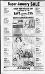
| OCR Text |
Show If DAVIS COUNTY CLIPPER. DECEMBER 29, 1982 crk; th S 77 deg. 30 E 168.53 ft alg sd crk; th N 0 deg. 18 W 138.44 ft to a pt 135 ft dist N ly fr the cen In of perp'ly sd crk ; th N 77 deg. 30 W 107 ft para to sdcrk;thN0deg. 18 W 198.24 ft to the pob. Cont. .81 Acres. Total Tax $11,485.98 Merrill L. Black, 03:035:0024, Beg on S side of rd 744 ft W of NE cor Lot 2, Blk K, NMC Plat Btfl Ts; th S 264 ft W 81 ft N 264 ft th E 81 ft to beg. Cont. .49 Acres. Total Tax $967.19 E&K Investment, 03:035:0029, W 2.50 chs of NE cor of Beg Lot 1, Blk 13, Plat NMC, Btfl Ts Sur; W60ft,S4chs, E60ft, N 4 chs to beg. Cont. .35 Acres. Total Tax $771.28 Randel K. Anderson, 03:035:0030, Beg 10 rds W fr NE cor of Lot 1. Blk K Plat NMC BtftTs Sur; E 74 ft, S 264 ft W 74 ft, N 264 ft to beg. Cont. .45 Acres. Total Tax $1,246.54 Fashion Village Group C-- 0 Mer-n- l. 03:035:0035, Beg on Sin of 500 S St at a pt wh is S 89 deg. 4200" E 396.98 ft fr the NE cor of Lot 2, Blk K, NMC Plat Btfl Ts Sur & Run th S 89 deg. 42' W 94.71 ft alg sd st th S 0 deg. 18 E 301.53 ft to a certain crk th S 77 deg. 30'00 E 97.12 ft alg sd crk; th N 0 deg. 18' W 323.05 ft to the pob cont. .67897 Acres. Total Tax $1,161.61 Greadick Corp., 03.035:0036, Beg at a pt 17.5 ft W fr NE cor Lot 2 Blk K, Plat NMC BtftTs Sur; th W alg S side of a cer 4 rd st runE&W 115.14ft mol, thSO deg. 18 E 235.39 ft mol to N In of pplv conv in 714-16th S 77 deg. 30'42 E 17.83 ft mol to a E of beg; th N 0 pt S 0 deg. deg. 15 W 260.59 ft mol to pob. Cont. .62 Acres. Total Tax... $2,000.84 Fashion Village Group C-- 0 Mer-ri- l, 03:035:0037, BegataptS89 deg. 42 W 17.50 ft alg th Sin of a st & SOdeg. 15' E 261 47 ft fr NE cor of Lot 2, in sd blk K Plat NMC Bo Ts Sur; & run th 5 0 deg. 15 E 125.0 ft to cen In of a crk th N 77 deg. 30 W 1 17.73 ft alg sd crk; th N 0 deg. 18 W 125.0ft th S 77 deg. 30 E 1 19.87 ft to the pob. Cont. .34 Acres. Total Tax $511.12 RDSG Co., 03:035:0039, Beg on theElnofHwy9l anSOftstrat a pt S 264 ft fr th S In of 500 S Str; Btfl, wh pt is due S 836.05 ft &S 89 deg. 33 46" W90.24ft fr th NE cor of Sec 25, T2N-R1SLM: th SOdeg. 00 04 E 141.84 ft alg sd hwy; th N 89 deg. 33'46 E 256.05 ft to th approx N bank of Mill Crk th N 61 deg 0951 E 262.48 ft alg sd bank, th N 17 ft to a pt 2 ft N 6 0.5 ft E of a metal post in the E end of a concrete wall, th S 89 deg. 3346 W 485.99 ft to the pob. Cont 1.273 Acres. Total Tax $897.99 Leland W. Brown, 03:035:0047, Beg on W In of St at Pt S 0 deg. 07 E 1472.13 ft alg sec In & E 162.74 ft fr NE cor Sec 25; 156.37 ft alg W In sd st; th W 259.64 ft to E In of st hy, th N 0 deg. 04 E 156.37 ft alg E In sd hy, th E 259.44 ft to pob. Cont. 1.084 Acres. Total Tax .. .$2,525.02 Clyde Williams Mills, 03 036:-007Beg. 103.25 rds South and 106.6 rds W of NE Cor Blk 39, Plat NMC, Bo Ts. E 7.5 rds, S 4.375 rds, W 7.5 rds N 4.375 rds to Beg. Cont. AprAc Total Tax $578.10 Keith D. Love, 03:036:0081, Beg 8.3 chs N and 1693.82 ft E fr SW cor Lot 3, Blk L, Plat NMC Btfl Ts S 128.5 ft MOl to N In St EE 70 Ft alg N In N 128.5 ft to S In Cooper Sub W 70 ft to Beg. Cont. .205 Acres. Total Tax $413.39 Valerie Jean Kirkland, 03:037:- 121.3 0036, Beg at pt N rds, W 28 rds fr SE Cor of NE 14 5 W of Sec 30. 2N. IE. SLM. rds, S 10 rds, E 5 rds, N 10 rds to Beg. Cont. .31 Acres. Total Tax $614.97 Isaac Lopez Trejo, 03:037:-005- Beg 1725.7 ft N and 653.75 ft W of SE Cor of NE 14 Sec 30, Tp2N, RglE, SLM E 62 ft, S 0 degs. 17 W 126.94 ft, N 89 degs. 33 W 62 ft alg N In of st N 0 degs. 17 E 126.45 ft to beg. Cont. .18 Ac. Total Tax $542.70 Lauren E. H. Bourland, 03:037:-009Beg at pt on S In St called Mill St. 105.625 rds South and 20.1 rds W and N 1 deg. 55 E 521 ft. and S 76 degs. 10 E 87 ft from NE cor Blk 39, Plat NMC, Btfl Ts, S 1 deg. 55 W 117.5 ft East 87 ft MOL to W In Hy No. 2. (Also called Orchard Drive) NEly alg W In Hy 90 ft MOl, to S In Mill St. N 76 degs. 10 W 100 ft MOl, to Beg. Cont. .224 Acres. Total Tax $665.51 Gail S. Eskelson, 03:039:0043, Beg on N side of 3 rd st 110.16 ft N 1324.5 ft. E fr SW cor of Lot 3, Blk L Plat NMC, Btfl Ts, S 89 degs. 58 E 85 ft. North 128.65 ft WW 85 ft S 128.72 ft to pt of Beg. Cont. .25 Acres. $262.57 Total Tax Kenneth Bywater Morton. Beg at SW Cor of Grantees enixting premises, ft N and 581.87 ft. W 1941.1 , fr SE Cor Sec 30, SLM; Thence N 24 degs. 30 15 E 97.21 ft alg Wly In of Grantees Premises to NWly Cor thereof; Thence W 49.25 ft, M or L, to Wly In of Grantors Land; South 20 degs. 01 W 64 ft, M or L, to T2N-RIE- pt N 47 degs. 31 15" W 40.23 ft fr Beg Thence S 47 degs. 31 15 East 40.23 ft to Beg, Cont. .085 Acres. $7.64 Total Tax Afton Page, 03:040:0027, Beg 30.4 ft W and 20.23 ft N 36 E of a Concrete Monu Marking the E 14 Cor SLM: Sec 30, T2N-R1Which pt is also 89.68 ft South and 29.19 ft West and N 8 degs. 36 East 12.14 ft fr the old E 14 cor said Sec 30; thence N 8 degs. 36 East 78.56 feet West 150.83 ft. to E In of a street South 10 degs. 28 West 78.99 ft. along said street to pt due W of Beg; Th E 153.5 ft MOL to Beg. Cont. .207 Acres. $285.04 Total Tax Grant J. Tobler, 03:040:0068, Beg at pt 2.11 chs N 27.500 chs E fr SE Cor of Lot 3, Blk L, Plat NMC: Btfl Ts Sur; North 105 ft. W 4.25 chs to Cen Ln of 4 rd st known as Hy 2 SW on Cen Ln of Said highway 110.1 feet to pt directly W of beg; Th E 4.75 chss to beg. Cont. .67 Acres. $1,003 .15 Total Tax 8 degs. Winfield S. Lemon, 03:040:0070, Beg 49 12 rds N and 216 rds E of SW Cor Lot 2, Blk L Plat NMC, Btfl. Ts, N 8.5 rds 19 rds, S alg cen hy No. 2, 8.5 rds, East to 19 rds to Beg. Cont. 1.00 Ac. Total Tax $442.81 John H. Sherwood, 03:045:0001 , All of Lot 15, Birdella Park Plat B, Sec 19; T2N-R1E- ; SLM: Cont. .21 Acre. Total Tax $570.77 Constant Aire Inc., 03:046:0006, All of Unit F and G, Van Dyke and Willey Condo. Sec 24; T2N-R- 1 W; SLM. Total Tax $1,242.88 Deseret Fed Savings and Loan Assn., 03:052:0016, Unit 16, Bldg. B, Park Place Cond. Blk 9 Pat NMC; Ts, Sur. Total Tax $271.07 Alan L. Chapman, 03:052:0028, Unit 28 Bldg C Park Place Cond Blk 9, Plat NMC; Btfl Ts, Sur. Total Tax $271.07 Joseph K. Everton, 03:054:-001Lot 18, Glendale Sub, Plat B, in Blk 11 Plat NMC Btfl Ts, Cont. .20 Acres. Total Tax $530.28 Hyrum C. Brough, 03:055:0011, All of Lot 11, Stone Creek Sub, Cont. .27 Ac; Also beg at NW Cor Lot 12; Sd sub; Sec 19, T2N-R1SLM: Thence SW 89 degs. 26 30 E 90.47 ft along N line said Lot 10 NW Cor ppty conv in 419-69thence South 0 degs. 19 West 75 ft; MOL, to SW'ly In said Lot 12; thence N 49 degs. 53 20 W 117.75 ft to POB. Cont. .07 ac, in all .34 Acres. Total Tax $155.50 Galen Ross, 03:056:0002, Lot 2, Cherry Park Sub, Blk 10 Plat NMC Btfl. Ts. Sur; Cont. .31 Acres. Total Tax $423.97 Art Killick Roberts, 03:061:-000Lot 1, La Vista Park Plat A, Blk 10 Plat NMC, Btfl Ts. Cont. .175 Acres. Total Tax $528.18 Pihl and Clark Enterprise, Bldg H Unit 67 amd Lakeview Condo of Btfl. NMC Plat Btfl Ts Sur. Total Tax $269.54 Pihl and Clark Enterprise, Bldg H Unit 71 amd Lakeview Condo of Btfl. NMC Plat Btfl Ts Sur. Total Tax $269.54 Floyd LeRoy Steed, 03:069 0029, Lot 12 Lynnhaven Plat E, in Blk 4 Plat NMC, Btfl Ts, Cont. .18 Ac Total Tax $518.25 R. Joyce Thomson, 03:069:0033, Lot 10, Lynnhaven Plat E, in Blk 4 Plat NMC Btfl Ts, Cont. .18 Ac. Total Tax $434.97 Donovan V. Howell, 03:070:-001Lot 12 Bountiful Park No. 1 Sec. 25 Tp2N, RglW, SLM, Cont. .153 Ac. Total Tax $355.77 Charles G. Bernard, 03:071:0015, Lot 15, Chateau Park Plat A, Sec 30, Tp2N, RglE, SLM, Cont. .17 Acres. $544.99 Total Tax Dean Macfarlane, 03:072:0050, Lot 50 Meadow Lane Plat C, Sec 30 Tp2N, RglE, SLM. Cont. .165 Ac. Total Tax $535.06 Bryce M. Singley, 03:074:0005, All of Lot 5 Fordham Commercial Park, Sec 25; T2N, R1W; SLM: Cont. .21 Ac. Total Tax $74.17 Bryce M. Singley, 03:074:0006, All of Lot 6 Fordham Commercial Park, Sec 25; T2N, R1W; SLM: Cont. .29 Ac. Total Tax $91.94 Clyde Williams, 03:074:0021, All Lot 21 Fordham Commercial Park, Sec 25; T2N, R1W; SLM: Cont. .20 Ac. Total Tax $72.64 Cresente R. Merrill, 03:075:-003Lot 38, Park View Sub, Sec 30, TP 2N, RG IE, SLM, Cont. .17 Acre. Total Tax $473.17 Geraldine M. Clark, 03:076:0002, Lot 2, Cooper Sub. Blk L, Plat NMC Cont. 30 Acres. Also beg N 0 degs. 23 W 130 ft fr SW cor Lot 17, said Cooper Sub; thence S 89 degs. 40 E 108 ft, thence N 0 degs. 23 W 20 ft thence W 108 ft thence S 0 degs. 23 East 20 feet to POB. Cont. .05 acres in all .35 acres. Total Tax $1,635.36 Don Hutchinson, 03:079:0017, Three Unit E in building E-Fountains of Btfl, Sec 30, T2N-R1- E SLM: Ownership of common areas 1.63 per- cent. $437.62 Total Tax Thane Atwood, 03:080:0024, Lot 24, Sunnyslope Sub. Blk 39, Plat NMC, Sec 30, T1N-R1SLM: Cont. .225 Acres $491.77 Total Tax E. G. Thorum, 03:081:0032, Beg at SW Cor of Lot 32, Colonial Sub Blk 39, Btfl Ts N 174. .4 ft E 17 ft NW Cor of Lot 32, SW along W line of said Lot 32 to Beg. Cont. .35 Acres. $556.60 Total Tax Gordon R. Bates, 03:083:0004, Lot 4, Colonial Heights Sub, in Blk 39, Plat NMC Btfl. Ts, Cont. .175 Acres. Total Tax $680.22 Employee Transfer Corp., Lot 3, Franz Sub, SLM: Sec 30, Cont. .235 Acres. $598.73 Total Tax Pierce H. Butler, 03:099:0001, Lot 1, Plat B, Shamrock Drive Sec 31 TP2N, RGIE, SLM Cont. .235 Acres. T2N-R1- Total Tax $614.77 Gerald E. Deters, 03:101:0012, Lot 12, Oak Haven Village Sub, except the foil. Beg S 0 degs. 07 E 87.89 ft. fr NE Cor said Lot 12, Sec. 30, T2N-R1N 89 degs. 56 E 89.90 feet South 0 degs. 07 24 West 41.24 feet W 89.23 feet South 89 degs. 56 West .50 feet thence N 0 degs. 07 W 41.14 feet to Beg. Cont. .25 Acres. Total Tax $904.33 Jay H. Jeppson, 03:101:0023, Beg at a pt 89.23 ft West of the SE Cor of Lot 12, Oak Haven Village Sub amended plat at a pt N 0 degs. 03 West 420.76 ft. fr thence SW cor of Sec 29, T2N-R1SLM: and run th East 89.23 feet thence N 0 degs. 07 24 East 50.24 ft. along thence W In of a st, thence West 89.90 feet MOL to the East In of said Lot 12 thence South 0 deg. 07 East 50.24 ft to thence POB. Cont. .105 Acres. Total Tax $23.68 Davis County Housing Authority, 03:103:0002, All of Lot B, Cinnamon Ridge; Sec. 17, 18, PAGE TWO T2N, R1E, SLM: Cont. 1.32 Ac. Out of 5 Total Tax $289.70 Harold R. Kendall, 04:001:0037, Bo-18- Beg 2102.5 ft South and 426.5 feet West of NE Cor of NWL4 Sec 20, TP 2N, RGIE, SLM, Thence E 80 ft. North 125 ft, and 80 ft, thence S 125 ft to beg. Cont. .24 Acres. Total Tax $60.87 Robert N. Pratt, 04:001:0057, Beg on N Ln of 900 N St S 0 degs. 05 Ea 519.5 ft and N 89 degs. 58 W 675.92 ft fr NE Cor NW 1,4 Sec 20. T2N-R1SLM: Th N 0 deg. 05 W 199 ft; N 89 degs. 58' W 114.85 ft; South 125.08 ft; South II degs. 37 E 65.47 feet; thence SELY to pt on N ln said st which pt is N 89 degs. 58 W of baeg; thence S 89 degs. 58' E 93 ft to Beg. Cont. .455 Ac. Total Tax $697.22 John W. Doramus, 04:002.3020, In N of ppty conv in Beg on Book 527 at Page 48, said pt N 89 degs. 36 E 12.72 being feet and N 9 degs. 36 W 83 fta from NW cor of Lot 21, amended and extended plat of Ellis Park Sub, Block A, Sec 20; T2N-R1SLM: North 89 degs. 36 East 100 ft to thence NE Cor of said ppty; North 9 degs. 36 West 83 ft. to South In of property conv in thence W along S In of said ppty 100 ft; thence S 9 degs. 36 West 83 ft MOL to POB. Cont. .20 Acres. Total Tax $58.89 Frank R. George, 04:002:0038, Beg on E ln of 10th E St, South 0 degs. 05' East 2234.4 ft and N 89 degs. 45 30 East 668.25 ft along center line of 4th North sstreet and South 89 degs. 56 East 8.25 feet and South 94.0 feet from NW Cor of NE 14 Sec 20, SLM: Thence South 76.26 feet along East T2N-R1- line said 10th East St, Thence South 89 degs. 56East 122.88 feet N 76.26 feet thence N 89 degrees 56 W 122.88 feet to beg. Cont. .215 Acres. Total Tax $250.34 Frank R. George, 04:002:0040, Beg South 0 degs. 05 East 2259.4 feet and North 89 degs. 45 30" East 668.25 feet along South line of 4th N St and S 89 degs. 56 degs. 30 E 131.13 feet and South 226.02 feet from NW Cor NE 14 Sec 20, T2N-R1SLM: North 89 egs. 51 W 111.86 feet to point on a 50 ft rad curve to left, on st, thence Sly along sd st to point 10 rds N of S In sd 14 sec, E 105 ft MOL, to pt S of beg, thence N 4.08 ft. MOL to beg. cont. .01 Acres. Total Tax $3.82 Shirl R. Harrison, 04:002:0059, S 1073.61 ft E and 996.61 Beg ft fr Nl4 cor Sec 20, T2N-R1SLM: Said pt being SE cor Lot 43, Forest Park Sub, Plat B South 89 degs. 19 W 150 ft; South 9 degs. 36 East 250.07 feet; North 89 degs. 36 East 150.12 feet to W In of a 66 ft RW; thence N 9 degs. 36 W 250.80 feet to Beg. Cont. .816 Ac. Total Tax $152.83 Frank K. Stuart, 04.002:0069, Beg at NE cor lot 16, Amd & ext plat of Ellis Park Sub, Plat A, SLM: th N 67 sec 20T2N-R1E- ; degs. 30'E 271.38 ft th S 1 degs. 06'E 165.70 ft to a pt N 0 degs. 59 E 50 ft & N 89 degs. 37W 50.26 ft & Wly 31.93 ft alg the arc of a 180.22 ft rad cur to the left &Nldeg.06W 427.96 ft fr theNWcoroflot 13, Eastwood Prk Sub, Plat A, th S 89 degs. 37'E 48. 17 ft to th W ln of a 54 ft wide st, th S Odegs. 59W 97. 10 ft mol alg sd W ln to a pt N 88 dgs. 54E of a pt 165.0 ft S of the pob. th S 88 degs 54W 300.44 ft mol to sd pt, th N 165.0 ft to pob. Cont. 1.372 acres. Total Tax ...$1,719.79 R. Eric Peterson, 04:002:0095, Beg at apt S 82 degs 4230W 237 ft &S 89 degs 56W 162.94 ft fr N S W cor of lot 8 Eastwood park Sub Plat A, sd N W cor of lot 8 being S 2239.67 ft & E 1904.66 ft fr N' cor of said sec 20, 2N, IE SLM, run th N 2 degs. 4430W 26 ft, th N 89 degs 56W 166.6 ft mol to pt of tang with a 330 ft rad curve to left, th Wly alg sd curve for an arc dist of 79.34 ft to Ely In of Davis Blvd, th S 9 degs 33E 409. 16 ft alg sd Ely ln to S ln of Howard ppty, th N 34.32 ft mol to the E cen In of a creek as desc by bndry ln agree 639-26th N 77 degs 0850E 30.81 ft alg sd cen In, th N 64 degs 45E 64.95 ft alg sd cen ln th N 74 degs 5858E 48.682 ft alg sd cen ln, th N 63 degs 0305E 47.351 ft alg sd cen ln, th N 269.59 ft mol to pob. Cont. 1.295 acres. Total Tax $729.00 Ezra T. Clark, 04:002:0096, Beg at apt on S In of a st S 82 degs 42'30 W 237 ft & N 89 degs 56W 42.94 ft alg sd S ln fr NW cor of lot 8 Eastwood Park Sub Plat A, sd NW cor of lot 8 being S 2239.67 ft & E 1904.66 ft fr N'i cor of sec 20. 2N, IE, SLM, run th S 204.59 ft mol to cen ln of creek as desc by run th S bndry ln agree 639-2658 degs. 5255W 59.263 ft, th S 63 degs. 0305"W 79 ft mol to apt due S of apt N 89 degs 56 W 120 ft fr the place of beg, th N 269.59 ft to S In of sd st, th S 89 degs. 56'E 120 ft to pob. Cont. .597 acres. Total Tax $971.52 Frank R. George. 04:002:0104, Beg S 0 degs 05E 2259.4 ft & N 89 degs4530"E 668.25 ft alg S ln 4th N st & S 89 degs 56' 30 E 131. 13ftalgSlnsdst&S 120 ft fr NW cor NE' sec 20, T2N-R1SLM th E 50 ft, S 110.1 ft mol to pt 10 rds N of S In sd 14 sec, W 50 ft thN 110.1 ft to beg. Cont. .126 Acres. Total $10.70 Tax Trivco Development Inc., 04:003:0032, Beg on W ln of 650 E st at apt N 760.27 ft & E 1 1 80. 14 ft &N 87 degs 12W27 ft fr SW cor of sec 20, T2N-R1SLM; run th S 2 degs 48W 103.19 ft alg sd Win to pt of tang of a 79 ft rad curve to the left, th SWly 123.82 ft alg arc of sd curve, th S 87 degs E 136.67 ft alg S ln of a st, th S 3 degs W 1 .0 ft, th N 87 degs W 137.41 ft to pt of tang of a 80 ft rad curve to right, th NWly 125.41 ft alg arc of sd curve, th N 2degs48'E 103.17 ft, th S 87 degs 12'E 1.0 ft to pob. Cont. .008 Acres. Total Tax . . $3.82 Trivco Development Inc., 04:003:0033, Beg at NE cor of lot 1 1 , Holmes Estates No. 1 , a sub of pt of SW1. of sec 20; T2N-R1SLM: run th S 4 degs 13W 79 ft; th N 87 degs 07W ft th S 1 deg 1.0 ft to an old fen In, of lot 61, Northern Hills, Plat B. Sec 20 & 21; ; th S 87 degs 07E 564.63 ft alg sdfen ln, thN 4 degs 13W80ft thN 87 degs 15W 1.0 ft to pob. Cont. .015 acres. Total Tax $1.53 J. Russell Scott, 04:003:0046, Beg on E ln st at pt 559.5 ft & S 99.98 ft E fr NW cor SW'1, sec 20, Tp 2N Rg IE, SLM N 0 degs 06 W 175.40 ft alg E Inst to Sin Bumingham Sub, N 89 degs 2530E 250 ft alg S ln sub, S 0 degs 06E 177.16 ft W 250 ft to beg. Cont. 1.03 Acres. Total Tax $1,576.59 SLM: Cont. .32 Acres. Total Tax $236.03 Robert W. Madsen, 04:015:0063, All of lot 63, Northern Hills, Plat B. Sec 20&21;T2N-R1E- ; SLM: Cont. .33 Acres. Total Tax $238.77 Robert W. Madsen, 04:015:0064, All of lot 64, Northern Hills, Plat B. Sec 20&21;T2N-R1E- ; SLM: Cont. .32 Acres. Total Tax $236.03 563.63 10'12W Charles L. Abercrombie. 04:004:0026, Beg on Win of st 5 1 deg02W962.34ftalgsec ln 6 W 33ftfrNEcorofSEl,sec 20: T2N-R1SLM: th S 1 deg 02W' 100 ft alg sd W ln of st, th 5 89 degs 07 W 167 ft th N deg 02 E 100 ft th N 89 degs 37'E 167 ft to pob. Cont. .39 Acres. Total Tax $799.33 Glen M. Anderson, 04:004:0043, 60 ln S of a ft st (T urkes Beg on Shoot Drive) SO deg 05E 330 ft to center ln sd st & N 86 degs 0030E 79.89 ft & N 82 degs 3830E 145.80ft alg sd cen In 6 S 5 degs 07E 30.05 ft frNW cor SE1, sec 20, T2N-R1SLM; S 5 degs 07E 113.48 ft alg remains of old fence; S 9 degs 40 E 26.60 ft; S 82 decs 38'30W 177.11 ft, morltoE ln of ppty conv in 264-27th Nly 19.25 ft. m or 1, to SW cor of ppty conv in 306-63N 82 degs 3830"E 80.08 ft N 122 ft, m or 1, to S In sd st; th N 82 degs. 3830E 80.25 ft, mol, to pob. Cont. 0.33 Acres. Total Tax $192.17 Associated Property Inv. Tax. 04:004:0065, Beg at apt wh is S 3 degs 5002"E 93 ft fr SE cor of lot 25, Orchard Hgts, Plat sec 20; T2N-R1SLM: run th S 3 degs 5002E 88 ft th N 89 degs 35'27W 123 ft to E In of Davis Blvd at apt on a 690 ft rad cur (rad pt bears N 86 degs 2213" W) th Nly 80 ft alg sd cur; th N 86 degs 3453' L 1 16.89 ft to pob. Cont .23 Acres. Total Tax $160.19 Alan V. Funk, 04:004:0069, Beg at th NE cor of lot 29, Orchard Hts Plat E, sec 20, T2N-R1SLM: th E 86.43 ft; th S 111 ft to th N ln of a str; th W 86.43 ft alg sd str; th N 1 ft to th pob. Cont. .22 Acres. Total Tax $927.56 Clyde R. McFarland, 04:004:0076. Begat apt 33 ft W& 585.71 ft N fr SE cor of sec 20.T2N-R1E- : SLM: thS 95.83 ft; thW 233.90 ft, mol, to apt on a 48 ft rad cur; th Nly & Wly 155.19 ft alg th arc of sd cur; th N 0 deg 3854E 53.44 ft; thE 309.64 ft to W ln of a st; th S 19.59 ft to pob. Cont. .682 Acres out of TotBo 1238-- 3 or al Tax $1,610.89 Kent Eugene Taylor, 04:005:0(Hli. Lot , Hillside Sub. sec, 17. tp. 2N Rg IE, SLM, Cont. .275 Acres Total Tax $607.64 Jeannette H. Smith, 04:005:0027. Lot 27, Hillside Sub. sec, 17, tp. 2N RglE. SLM, Cont. .215 Acres Total Tax $698 36 Henry Mack Smith, 04:005:0038. Lot 38, Hillside Sub. sec. T2N-R1SLM: Cont. .20 Acres. Total Tax $300 00 Ogden L. Wastlund, 04:005:0097, Lot 97, Hillside Sub, sec 20. tp 2N, rg IE, SLM, Cont. .213 Acres. Total Tax $562.37 "B, Geraldine H. Williams, 04:005:0102. Lot 102, Hillside Sub. sec 20, tp 2N, Rg IE, SLM Cont. .26 Acres plus: beg at the SE cor of lot 101. Hillside Subd; & run th N 89 degs 58 W 3.0 ft; th N 36.0 ft; th S 89 degs 58E 3.0 ft to th E ln of sd lot 101 ; th S 36 ft to the pob. Cont. .002 acres. TGotal .262 Acres out of Total Tav tmi 00 Steve S. Porter, 04:006:0063, Lot 63, Hillside Sub, sec 20, Tp 2N, Rg IE, SLM, Cont. .212 Acres. Total Tax $564.66 Wallace H. Burnham, 04:007:0014, Lot 14, Foothill Acres Plat A, sec. 20, Tp 2N, Rg IE, SLM, Cont. .232 Acres Total Tax $549.83 Jerold F. Flannery, 04:008:0088, Lot 88, Bountifuls Lake Hills Plat B sec 20, Tp 2N, Rg IE, SLM Cont. .25 Acres. Total Tax $740.83 R. Kent Madsen, 04:015:0024. All of lot 24, Northern Hills. Plat B. Sec 20 & 21; T2N-R1E- ; SLM: Cont. .27 Acres. Total Tax $227.94 Bonneville Inc., 04:015:0027, All of lot 27, Northern Hills, Plat B. Sec 20 & 21; T2N-R1SLM: Cont. .45 Acres. Total Tax $258.69 James C. Me Neil, 04:015:0033, All of lot 33, Northern Hills, Plat B. Sec 20&21;T2N-R1E- ; SLM: Cont. .38 Acres. Total Tax $246.38 Bonneville Inc., 04:015:0034, All of lot 34. Northern Hills. Plat B. Sec 20 & 21; T2N-R1SLM: Cont. .35 Acres. Total Tax $241.06 Bonneville Inc., 04:015:0035. All of lot 35, Northern Hills, Plat B. Sec 20 & 21; T2N-R1SLM: Cont. .47 Acres. Total Tax $263.54 Bonneville Inc., 04:015:0042. All of lot 42, Northern Hills. Plat B. Sec 20 & 21; T2N-R1SLM: Cont. .37 Acres. Total Tax $245.62 Camden Enterprises, 04:015 0044, All of lot 44, Northern Hills, Plat B. Sec 20&21;T2N-R1E- ; SLM: Cont. .48 Acres. Total Tax $264.31 Bonneville Inc., 04:015:0046, All of lot 46, Northern Hills, Plat B. Sec 20 & 21; T2N-RIE- ; SLM: Cont. .47 Acres. Total Tax $263.54 R. Kent Madsen, 04:015:0049. All lot of 49, Northern Hills. Plat B. Sec 20 & 21; T2N-R1SLM: Cont. .28 Acres. Total Tax $228.70 Paul Landes, 04:015:0050, All of lot 50, Northern Hills, Plat B. Sec 20 & 21; T2N-R1SLM: Cont. .26 Acres. Total Tax $225.64 Trent J. Parker, 04:015:0052, All of lot 52, Northern Hills. Plat B. Sec 20 & 21; T2N-R1SLM: Cont. .37 Acres. Total Tax $245.62 Frederick P. Me Brier, 04:015:0053, All of lot 53, Northern Hills, Plat B. Sec 20 & 21; SLM: Cont. .41 Acres. Total Tax $251.54 Eldon C. Evans, 04:015:0056. All of lot 56, Northern Hills, Plat B. Sec 20 & 21; T2N-R1SLM: Cont. .25 Acres. Total Tax $222.84 Bonneville Inc., 04:015:0060. All of lot 60, Northern Hills, Plat B. Sec 20 & 21; T2N-R1SLM: Cont. .29 Acres. Total Tax $230.23 Robert Kimsev. 04 015:0061, All T2N-R1- T2N-R1E- H. Colleen Christensen, 04:017:0008, Lot 8, Ellis Park Blk A, Cont. .35 Acres except th E foil, beg at NE corsd lot 8, thS 63 degs 1229W 21.60 ft, th S 13 degs 5930E 79.74 ft toEly lnsd lot, thN 87. 11 ft alg E In sd lot to pob. Cont. .033 Ac also th following parcel in sec 20; T2N-R1- E SLM, begat SE cor sd lot 8, Ellis alg blk A, th N 73.98 ft alg E lnsd lot, thS 13 degs 5930E 81 .57 ft to N ln of a st, th N 74 degs 27W 1 1 .27 ft alg sd st, th Wly 7.93 ft alg sd st alg arc of a 25 ft rad curve to left to pob. Cont. .033 acres in all. 35 Acres. Total Tax$823.23 Velton S. Casler, 04:021:0008, All of Lot 8, Mountain Park Plat "WB sec 20, T2N-R1SLM: Cont. .447 Acres Total Tax $1,602.56 Roy L. Miller, 04:022:0015, Lot 15, Bumingham Sub, sec. 20, tp 2N, rg IE, SLM, Cont. .195 Acres. Total Tax $503.54 Curtis M. Torgerson, 04:025:0023, Lot 23, Central Heights Blk B, sec 20, tp 2N, rg IE, SLM Cont. .265 Acres. Total Tax $774.20 John D. Whitchurch, 04:027:0007, Lot 98, Central Hgts Blk F, sec 20. tp 2N, rg IE, SLM Cont. .295 Acres excepting the North 2.0 ft thereof of sd lot. Total 0.292 Acres. Total Tax$638.66 Richard C. Spencer, 04:031:0009, All of Lot 9, Holmes Estate No. 1, sec 20;T2N-R1E;SLCont. .35 Acres. Total Tax $1,487.91 R. Jed Allen, 04:032:0004, All of Lot 4, Gale Sub; sec 20, Cont. .24 Acres. Total Tax $561.29 Glen M. Anderson, 04:033:0063, Lot 63, Mountain Park D, sec 20, tp 2N rg E, SLM Cont. .30 Acres. Total Tax . . .$1,129.14 Thomas L. Steward, 04:038:0021, Lot 8, blk 2, Bountiful Heights, Plat asec 20, tp 2N, rg IE, SLM Cont. .352 Acres. Beg. NW cor Lot 9, blk 2, Plat A Btfl Hts, Sub, sec 20, tp 2N, rg IE, SLM S 65 degs 50E 132.83 ft to NE cor Lot 9 S 49 degs 56W 20 ft N 57 degs 3439W 125.43 ft mol to beg. Cont. .03 Acres. Total in all, cont. .382 Acres. Total Tax $583.31 Preston C. Allen, 04:043:0011, All of Lot 11, Vistaview Plat A. sec 20; T2N-R1SLM: Cont. .25 Acres. Total Tax$l,284.80 Gary Edward Reed, 04:045:0007, All of Lolt 7 Reed Sub, amended, sec 20, T2N-R1- SLM: Cont. .22 Acres. Total Tax $1,253.79 Western States Title Co., 04:046:0016, Beg at apt on th Btfl City Bndy ln wh iss 0 degs 5639W alg sec In 495 ft & S 89 degs 03'21E 495 ft fr th NW cor of sec21;T2N-RlE;SLM- : th S 890 degs 0321E 1013.22 ft; th S 0 degs 5639W 100 ft; th S 33 degs 3749E 595 ft, mol, to S In of ppty; th S alg sd S In 1203 ft, mol, to a pt on th Wly ln of Quailbrook Sub Plat th N 17 degs 4450"W 444 ft, mol, to apt due S of th pob; th N 0 degs 5639 E 230 ft to th pob. Cont. 14.95 Acres. Total Tax $104.67 Western States Title Co. of DC, 04:046:0054, Beg at apt 30 rods Efrth NW corofsec21,T2N-R1E- ; SLM: th E 1013.628 ft to the In of Btfl City; th S 0 degs 5639W 538.341 ft; th N 89 degs0321W 1013.220 ft; thN 495 ft to th pob. Cont. 12.183 Acres annexed out of 1 5 Total Tax $42 or .78 "A, Rigard Investment Corp 04:048:0024, All of Lot 24, Quailbrook Plat A. Sec 20-2T2N-R1SLM: Cont. .24 Acres. Total Tax $215. Rigard Investment Corp, 04:048:0029, All of Lot 29, Quailbrook Plat A. Sec 20-2SLM: Cont. .21 Acres. Total Tax $191.06 T2N-R1- Development Associates, 04:048:0048, All of Lot 48 Quailbrook Plat A. Sec 20-2SLM: Cont. .49 Acres. Total Tax $265.84 T2N-R1- Development Associates, 04:048:0050, All of Lot 50 Quailbrook Plat A. Sec 20-2T2N-R1SLM: Cont. .46 Acres. Total Tax $259.45 Development Associates, 04:048:0051, All of Lot 51 Quailbrook Plat A. Sec 20-2T2N-R1SLM: Cont. .62 Acres. Total Tax $288.72 Rigard Investment Corp, 04:048:0053, All of Lot 53 Quailbrook Plat A. Sec 20-2T2N-R1SLM: Cont. .25 Acres. Total Tax $222.84 Melvin Jay Mills, 04:049:0010, All of Lot No. 10, Vineyard Sub, sec 21; T2N-R1SLM: Cont. .487 Acres. Total Tax $647.07 Stout Const. Inc., 04:049:001 , All of Lot No. 11, Vineyard Sub, sec 21;T2N-R1E- ; SLM: Cont. .255 Acres. Total Tax $215.20 Steeks Investment, 04:049:0012, All of Lot No. 12, Vineyard Sub, sec 21; T2N-R1SLM: Cont. .275 Acres. Total Tax $221.06 Rex A. Reed, 04:049:0018, All of Lot No. 13, Vineyard Plat B. sec 21; T2N-R1SLM: Cont. .33 Acres. Total Tax $232.66 Rex A. Reed, 04:049:0019, All of Lot No. 4, Vineyard Plat B. sec SLM: Cont. .28 21; T2N-R1Acres. Total Tax $221.06 Christopher M. Bigelow, 04:051:0027, All of Lot 27 Granada Hills No. 2, Sec21;T2N-R1E- ; SLM: Cont. .31 Acres. Total Tax $1,459.19 William L. Smith, 04:053:001 1 , AH of Lot 1 1 Granada Hills No. 4, Sec 21; T2N-R1SLM: Cont. .27 Acres. Total Tax $174.46 Utah State Retirement Fund, 04:060:0013, Beg N 0 degs 18W 1069.3 ft & N246.ll ft & E 1344.78 ft fr SW cor Sec 28 T2N-R1- E SLM, E 1295.22 ft to NE cor SE'A of S W' sec 28 S 1320 ft to sec ln W 1058.9 ft N 26 degs 31W 536 ft N 60 degs 02W 3.05 ft th N 838.87 ft to beg. Cont. 38.554 Acres. Total Tax $10,694.07 James R. Hatch, 04:061:0002, Beg at a pt 770.0 ft S& 1320.0 ft E of th NW cor of sec 28 T2N-R- 1 E; & run thN 100.0 ft thW 150.0 ft, th S 100.0 ft th E 150.0o ft to the pob. Cont. .345 Acre. Total Tax $81.39 James R. Hatch, 04:061:0010, Beg at a pt 870.0 ft S& 1320.0 ft Efr th NW cor of sec 28, T2N-R1& run thN 100.0ft thW 150.0ft th S 100.0 ft th E 150.0 ft to th pob Cont. .345 Acres. Total Tax $81.39 Shirl Ray Harrison, 04:061:0014, Beg S 89 degs. 38 30" E 1592.88 ft and N 0 dgs. 10 32 E 513 ft fr SW Cor of NW14 Sec 28; T2N-RISLM: Th N 0 degs. 10 32 E 152 ft thence S 89 degs. 38 30" W 100 ft thence S 0 degs. 10 32 W 152 ft thence N 89 degs. 38 30 W 100 ft to POB. Cont. .35 Acres together with easement. Total Tax $82.15 Ted Samuelson, 04:062:0126, Lot 126 Canyon Crest No. 2, Sec 28 T2N R1E, SLM COnt. .22 Acres also Beg at NE Cor Lot 126, thence S 32 degs. 02 30 W 123.67 ft thence S 35 degs. 50 East 20.60 ft th N 32 degs. 02 30 E 71.07 ft, thence N 14 degs. 30 E 63.31 ft to POB. Cont. .05 also known as Lot 126A Canyon Crest No. 4, Cont. in all .27 Acres. Total Tax $1,083.62 James M. Harrison, 04:063:0160, Lot 160, Canyon Crest No. 6, Sec 28 T2N R1E, SLM, Cont. .275 Acres. Total Tax $207.31 Merrill W. Beck, 04:063:0173, Beg at SW cor Lot 173, Canyon Crest Plat No. 6, Sec 28; T2N-RISLM: Th N 40 degs. 23 East 364.89 ft to Sly line of a st, at a pt 6.22 feet S 59 degs. 17 E Of NW Cor said lot, thence S 59 ft to NE degs. 17 E 91. Cor said lot, th S 32 degs. 43 36" W 502.80 ft to SE cor said lot, th N 12 degs. 46 W 197 ft to POB. Cont. 1.40 Acres. Total Tax $1,344.06 Marilyn Olsen Taylor, 04:067:-000All of Lot 28, Lakeview Terrace, Sec 28-2T2N-R1SLM: Cont. .471 Ac. Total Tax $242.15 John O. Dawson, 04:067:0034, All of Lot 28, Lakeview TerT2N-R1race, Sec 28-2SLM: Cont. .28 Acres. Total Tax $204.25 David R. Stone, 04:067:0036, All of Lot 26, Lakeview Terrace, T2N-R1SLM: Sec. 28-2Cont. .36 Acres. Total Tax $1,695.72 D and B Enterprise, 04:069:-001Beg at a pt S 89 degs. 43; 20;; W 667.81 ft along sec ln fr NE Cor of NW 14 of SLM: Wh Sec 29; T2N-R1pt is also S 89 degs. 43 20 W 132 ft fr W line of 800 E st and Run Thence N 3.28 ft; thence N 88 degs. 48 W 175.37 ft MOL, to NE cor of thence S ppty conv in 609-50 degs. 05 40 E 218.66 ft; thence S 89 degs. 15' 04 E 111.10 ft to a pt S 89 degs. 56 41 W 178.48 ft from W line of sd 800 E st; thence N 89 degs. 56 41 E 46.48 ft; thence N 4 degs. 46 E 213.80 ft par to and 132 ft W of W In of said street to POB. Cont. .840 Acres. Total Tax $242.98 Charles Taggart Mills, 04:069:-002Beg 544.50 ft South and 981.97 feet E fr NW cor Sec 29, TP2N, RGIE, SLM E 125.90 ft South 163.20 ft MOL to N line Larsen Hts Sub, North 68 degs. W 136.20 ft MOL to pt 112 ft due S fr beg, N 112 ft to beg. Cont. .399 Acres. Total Tax $518.95 H. C. Burton, 04:069:0065, Beg on the S ln of 500 So. st. at a pt South 0 degs. 06 E 549.86 ft and N 89 degs. 47 30 E 1866.28 ft fr the NW Cor of Sec 29, T2N-R1SLM and run thence S 0 degs. 12 30 E 283.47 ft, MOL, to the cen ln of Holbrook Creek; thence S 78 degs. 09 E 7.67 ft along said cen In; thence S 0 degs. 12 30 E 20 ft MOL, to the Nly ln of Bali Hai run thence S Sub, Plat 77 degs. 51 15 E 93.49 ft along said Nly In; thence N 89 degs. 47 30" E 55.14 ft along said Nly ln; thence N 0 degs. 12 30 W 325 ft to the South line of said st; thence S 89 degs. 47 30 W 154 ft along said st to the POB. Cont. 1.072 Acres. Total Tax $793.31 H. C. Burton, 04:069:0066, Beg on the S ln of 500 So. st. at a pt South 0 degs. 06 E 549.86 ft and N 89 degs. 47 30 E 1866.28 ft fr the NW Cor of Sec 29, T2N-R1SLM and run thence S 0 degs. 12 30 E 283.47 ft, MOL, to the cen ln of Holbrook Creek; thence N 78 degs. 29 09 W 45.29 ft along said cen ln; thence N 82 degs. 23' 41 West 48.48 ft along said cen ln; thence N 81 degs. 39 29 W 17.84 ft along said cen line to the E line of 750 E st; thence N 0 degs. 12 30 W 265 ft along said E line N to the South line of 500 So. St; Thence N E 110 ft 89 degs. 47 30 along said S line to the POB. Cont. .692 Acres. Out of Bo 1407-- 3 and Bo 1407-- 5 or 0050 and Total Tax $226.46 Frank Granato Import Co., Beg on S line of a 66 ft wide st, at a pt 544.5 ft MOL, S and 3346.5 ft E of N 14 cor of Sec 29, T2N-R1SLM: Wh pt is 1.0 ft S of S line of an exist sidewalk and run th S 174 ft th E 82.5 ft thence N 174 ft to S line of sd st, th W 82.5 ft along said st to POB. Cont. .22 Acres. Total Tax $310.59 Larry C. Tingey, 04:071:0006, Beg on S ln of a 50 ft st at pt N 0 degs. 09 E 788.02 ft and S 75 degs. 25 E 809.05 ft fr SW cor of NW 14 Sec 29, TP2N, RGIE, SLM, South 14 degs. 35 W 118.54 ft. East 93.51 feet, North 14 degs. 17 30 E 93.0 feet, N 75 degs. 25; West 90 ft along S line said st to Beg. Cont. .22 E, Total Tax $793.45 Charles W. Nye, 04:071:0022, Beg at a pt South 0 degs. 004 45 E 485.75 feet and West 176 ft from SE Cor Canyon Rim Sub, sd pt is 80 rds S and 176 ft W of the accepted cen of Sec 29; T2N-R1SLM: Th S 89 degs. 57 W 87.53 ft MOL, to th Ely line of Emerald Hills Plat D, thence Ely 88.04 ft alg arc of a 475.11 ft rad cur to the right, thence N 8.13 feet to the POB. Cont. 0.008 Acres. Total Tax $3.82 J. G. Stephenson. 04:071:0030. Beg on N side of MiU Creek at pt N 324.04 feet and E 558.66 ft and N 8 degs. 46 30" W 134.5 ft, MOL, fr SW cor of NW14 Sec 29, T2N-R1SLM: Thence N 8 degs. 4630" W 11.5 ft, M or L; N 2 degs. 34 30" W 16.0 ft; N 74 degs. 55 W 108 ft; South 1 deg. 38 West 30 ft, M or L, to N Bank of Crk; thence Ely alg sd N bank to beg. Cont. .09 Ac. $9.93 Total Tax Myme M. Collier, 04:072:0033, Beg at the SW cor of the NW14 of the SE 14 of Sec SLM: Th N 0 29, T2N-R1E 377.34 ft degs. 11 18 along the 14 sec ln; thence N 89 frhd. 35 45" East 84.12 ft; thence S 0 degs. 12 44 W 412.40 ft to a pt (on N side of an exist str radial bearing South 16 degs. 58 09 E) on a 118.12 ft rad cur to the left; thence SWly 40.31 ft along sd cur; thence N 87 degs. 01 00 W 48.24 ft to the W line of said SE14; th N 0 deg. IF 18 East 50 ft along said ln to the POB. Cont. .84 Acres. Out of $252.15 Total Tax Welden L. Daines, 04:073:0020, All of Unit 210, 425 Medical Dr. Cond Phase I. Sec 29; T2N-R1SLM: 1.888. $463.60 Total Tax Charles Taggart Mills, 04:075:-000Beg on Nly ln Lot 8, Larson Heights Sub, said pt being 1115 ft E and 710.5 ft S MOL fr NW Cor Sec 29 TP2N, RGIE, SLM, South 14 ft MOL to pt 1115 ft East and 724.5 ft South of NW cor Sec 29, N 65 degs. W 74 ft MOL to pt 1048.7 ft East of W line of Sec 29, N to N line of Low 8; South 68 degs E along ln of Lot 8 to Beg. Cont. .016 Acres. $3.82 Total Tax Vem Thomas Neilson, 04:077:-005Plat Lot 57, Bali-Ha- i, B, Sec 29, TP2N, RGIE, SLM Cont. .26 Acres. $871.22 Total Tax Ann K. Winn, 04:077:0071, Lot 71 Bali-HC, Sec. 29, T2N-R1SLM, Cont. .22 Acres. $738.85 Total Tax Oral Steele Johnson, 04:077:-008Lot 82, Bali Hai C, Sec SLM, Cont. 29, T2N-R1.24 Acres. $897.45 Total Tax 04:084:-000Curtis A. Page, Beg E 1011.75 ft and S 519.86 ft and S 89 degs. 49 30 W 64.90 ft and S 45 feet and South 76 degs. 58 East 12.0 ft fr Nl4 cor Sec 29. T2N-R1SLM; thene S 13 degs. 02 W 159.0 ft; South 0 degs. 56 W 174.83 ft; thence along arc of 12 ft rad curve to right 18.65 ft; W 29.84 feet; thence along arc of a 56 ft rad curve to left 67.94 ft; North 20 degs. 29 E 254.98 ft; thence N 17 degs. 27 E 145.78 ft to beg, Cont. .21 Acre. Except the N 60 ft thereof. $19.86 Total Tax Frank H. Cutler, 04:085:0031, Lot 31, Cottonwood Acres B, Sec 29, T2N-R1SLM; Cpnt. .36 Acre. Total Tax $547.43 04:086:-001B. Owen Kimbill, All of Lot 14 Bountiful Hills Estates, Sec 29; T2N-R1SLM; Cont. .38 Acres. Total Tax $1,073.03 Patricia S. Smith, 04:087:0099, Lot 99, Bountiful Hills Addn SLM; B, Sec 29, T2N-R1Cont. .35 Acres. Total Tax $1,013.47 Dewey C. MacKay, Jr., 04:088:-001Bountiful Hills Lot 13, Sub, Sec. 29, TP2N, RGIE, SLM, Cont. .455 Acres. Total Tax $1,097.56 Arthur C. Wiscombe, 04:088:- 0030, Lot 29, Btfl Hills Sub; SLM: Sec 29; T2N-R1Cont. .476 Acres. Total Tax $249.03 Karen Henderson, 04:088:0041, Lot 39, Bountiful Hills Sub, Sec 29, TP2N, RGIE, SLM Cont. .46 Acres. Total Tax $1,083.81 Alan Lange Smith, 04:093:0021, AH Lot 21, Woodland Sub, situated in Sec 29, TP2N, RGIE, SLM, Cont. .231 Acs 7 ft Lot 22, Woodland Sub, Sec 29, TP2N, RGIE, SLM, Cont. .03 Ac. Total .26 Total Tax $638.97 Glen E. Everett, 04:094:0002, All of Lot 2, Holbrook Heights Plat A, Sec 29; T2N-R1SLM: Cont. .29 Acres. Total Tax $194.32 Glen E. Everett, 04:094:0003, All of Lot 3, Holbrook Heights Plat A, Sec 29; T2N-R1SLM: Cont. .30 Acres. Total Tax $197.06 Glen E. Everett, 04:094:0004, AH of Lot 4, Holbrook Heights Plat A, Sec 29; T2N-R1SLM: Cont. .27 Acres. TotalTax Glen E. Everett, 04:094:0007, Lot 7, Holbrook Heights Plat A. Sec. 29; T2N-R1SLM: Cont. .36 Acres. TotalTax $205.16 Boyd A. Everett, 04:094:0022, Lot 22, Holbrook Heights Plat A. Sec. 29; T2N-R1SLM: Cont. .18 Acres. Total Tax $800.00 Richard L. Stout, 04:095:0020, Lot 20, Canyon Rim Sub, amended Cont .28 Ac also beg SE cor Lot 19 Canyon Rim amended South 14 degs. 15 45 W 38.81 ft South 75 E 22.33 ft, degs. 44 15 North 15 degs 39 W 44.77 ft to beg. Cont. .02 Ac in all 30 Acres. Total Tax $682.20 Sara M. Bishop, 04:101:0003, Lot 3, Canyon Crest A, Sec 29, TP2N, RGIE, SLM, Cont. .555 Acres. Total Tax $1,392.40 Zions First Natl Bank, 04:102:-000Lot 67, Bountiful Hills Addn A, Sec 29, TP2N, RGIE, SLM Cont. .275 Acres. Total Tax $939.98 Willard L. Nelson, 04:102:0013, N 82 ddegs. 55 20" W Beg 8.05 ft fr NE cor Lot 56, Btfl Hills Addn A, Sec 29; T2N-R1SLM: Thence S 17 degs. 42 W 390.95 feet to cen of Mill Creek, thence S 84 degs. 41 30 West 65.88 ft thence N 12 degs 48 30 E 400.38 ft thence South 82 E .43 ft to degs 55 20 POB. CCont. .7131 Acres. TotalTax $1,303.62 John L. Knight, 04:103:0025, All of Lot 26, Bountiful Hills, Plat C Sec 29, T2N-R1SLM, Cont. .86 Acres. Total Tax $1,673.04 James A. Collier, 04:103:0034, Beg at a pt N 304.47 feet fr SW cor of Lot 1, Bountiful Hills C, a sub of pt of SE 14 SLM: of Sec 29; T2N-R1Run thence S 87 degrees 00 E 48.24 ft thence SWly along Nly side of a st 14 degs 32 29.97 ft, thence along 16 said st along a 20 ft rad curve to right 29.51 ft thence N 27.31 feet MOL to POB. Cont. .02 Acres. S3.82 TotalTax Reid Scott Holbrook, 04:104:-004All of Lot 49, Bountiful Hills D, Sec 29, T2N-R1SLM: Cont. .23 Acres. $214.44 Total Tax Reed L. Roberts, 05:001:0032. ft W Beg 2 rds South and 120 of NE cor NWI4 Sec 31, TP2N, RGIE, SLM. West 130.2 ft, South 10.8 rds, East 130.2 ft. North 10.8 rds of Beg. Cont. M or L, .52 Acres. $754.48 Total Tax Devcon Ind Inc., 05:001:0050, cor of NW1,4 of Sec 31 T2N-R1- SLM: Th W 260.97 ft to E ln of Villa Nova Cond; thence S 0 degs. 09 55" W 6.58 ft; thence N 89 degs. 55 28" E 260.97 ft to W line of said st, thence N 6.24 ft to POB. Cont. .038 Acres. $9.93 Total Tax Davis County Housing Authority, 05:002:0012, Beg on W side of 4 rd st which is N 0 degs. 56 W 751.08 ft and N 89 degs. 07 W 1836.09 ft and N 23 degs. 32 E 373.53 ft and N 66 degs. 28' West 33 ft fr SE cor NE 14 Sec 31. T2N-R1SLM: North 85 degs. 10 15" W 442.69 feet W South 29 degs. 03 15 98.01 feet S 86 degs. 12' E 452.80 feet N 23 degs. 32' East 93.92 feet to Beg. Cont. Acres Life Estate in Mary . Bernardo. $209.08 Total Tax Janice Lloyd Fadel, 05:002:0039, Beg on W line of 200 E ext, at pt 877.43 ft M or L West and 126.78 feet S fr NE cor SLM: Sec 31, T2N-R2Thence N 14.31 ft thence N 68 degs. 04 50" West 205.72 feet, thence SW'ly 24.42 fee! along arc of a 15 ft rad curve to left Ely ln of Orchard Dr thence SWly 88.0 feet M or L alg E'ly In said st to a pt due W of Beg. thence E 240 ft M or L to POB. Cont. .30 Acres. $172.62 TotalTax Homer F. Taylor, 05:002:0080, Beg, 3790 ft E and 823.61 ft South from thence NW cor of Sec 31, TP2N, RGIE, SLM, 1 West South degs. 46 64.36 ft; thence N 74 degs. 38 14" W 104.383 ft. N 15 degs. 21 46 East 119.09 ft; to thence SEly In of a st; thence S 40 degs 15 07" East 106.241 ft; thence South 74 degs. 38 14" E 68.54 feet to the POB. $565.42 TotalTax Frank R. Leibrock, 05:008:0040, Unit 40, Building E, Villa Nova, Sec 31; T2N-R1SLM: Total Tax $674.46 William G. OToole, 05:011:-008All of Lot 84, Btfl Acres No. 2 Sub, situated in Sec 31, TP2N, RGIE, SLM Cont. .205 Ac. Total Tax $540.98 S. D. Birdsong, 05:011:0084, Lot Bountiful Acres Sub, 131, No. 2, Sec. 31; TP2N, RGIE, SLM, Cont. .21 Acres. Total Tax $477.56 Millard B. Rice, 05:013:0007, All Lot 7, Mountain Aire Sub, SLM: Sec 31; T2N-R1Cont. .363 Acres. Total Tax $602.41 Murray 1st Thrift and Loan Co., 05:017:0017, Lot 17, Mueller Hgts Sub, Plat A, Sec 31, TP2N, RGIE, SLM, Cont. .26 Ac. Total Tax $687.86 Frank D. Acord, 05:017:0039, Lot 39, Mueller Hgts Sub, Plat A, Sec 31, TP2N, RGIE, SLM, Cont. .20 Ac. Total Tax $611.26 Bannack Co. Trust, 05:018:0058, Lot 58, Mueller Heights B, Sec 31, TP2N, RGIE, SLM. Except the west 4 ft thereof. Cont. .21 Acres. Total Tax $652.52 James L. Lindsay, 05:021:0002, Lot 2, Oak Hills Sub. Plat A, in Sec. 31, TP2N, RGIE, SLM, Cont. .237 Acres. Total Tax $579.63 David R. Vance, 05:022:0040, Beg at NE cor of Lot 35, Oak Hills, Plat C, Sec 31; T2N-R1SLM: Run thence S 89 degs. 04 W 186.85 feet; thence S 11 degs. 36 25 E 40.85 feet; thence S 48 degs. 20 East 73.68 feet; thence N 89 degs. 04 Eat 25.05 feet; thence N 0 degs. 56 W 86.0 feet; thene N 89 degs. 04 Eat 100 ft; thence N 0 degs. 04 West 4.0 feet to POB. Cont. .195 Ac. Total Tax $19.10 Franklin R. Priest, 05:023:0015, Lot 15, Rainbow Hills Add. No. 1, Sec 31 PT2N, RGIE, SLM, Cont. .25 Acres. Total Tax $619. Lynn Roger Calder, 05:042:0011, S 35 0 E 925 ft N Beg degs. 89 degs. 59 East 360.49 feet and South 0 degs. 01 East 30 ft fr W 14 cor Sec. 32 TP2N, RGIE, SLM N 89 degs. 59 E 69.75 feet South 0 degs. 01 East 120 ft S 89 degs. 59 West 93.91 feet N 0 degs. 35 West 94.76 feet thence 39.52 ft around a curve to the E of 25 feet raduis to beg Cont. .256 Acres. Total Tax $804.24 Bruce V. Broadhead, 05:042:-001- Beg 924.76 feet N and 89 degs. 59 East fr W 14 cor Sec 32, T2N-R1SLM: West 264.76 feet South 121.72 feet South 52 degs. 13 20 East 42.74 feet thence around arc of a 225 ft rad curve to right for a arc dist of 45.43 ft M or L to pt South 49 degs. 20 40 West of beg, thence N 49 degs. 20 40" Eat 259.85 feet to Beg. Cont. .73 Acres. TotalTax $133.17 Elmoyne B. Holbrook, 05:042:-001- 5, Beg N 89 degs. 59 East 1043 feet and South 22 degs 29 West 71.65 feet from W 14 corner Sec 32 T2N-R1SLM: South 53 degs. 10 40" West 291.03 feet South 36 degs. 49 20 East 173.74 feet M or L to West line of Oak Vista Park No. 1; thence North 22 degs 29' Eat 339.38 feet M or L along said W line of Sub to Beg. Cont. .58 Acres. Total Tax $758.37 (Continued) |