| OCR Text |
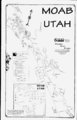
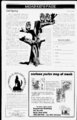
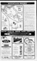
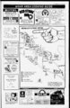
Show Moab Happenings 8A April 1998 Get Off Your Seat And On Your Feet Moab is blessed with a wide variety of outdoor activities that can be done in or near the vicinity of the center of town. One of these is hiking. It is possible to start from the center of Moab and take some very interesting, short hikes or a few minutes drive in any direction will put you at a trailhead of your choosing. The Grand County Travel Council and the BLM have biochures available describing many of these trails in great detail and these brochures are available at the Moab Information Center. We are just giving you a peek at the variety of hikes. As with all activities in the Southwest, w'e caution you to take plenty of water and let someone know where you have gone. fantastic shapes. Climbers occasionally scale these mudstone towers (be cautious of hiking directly below a climber!). Note: This trail has a western exposure and can be exceptionally hot on summer afternoons. Mountain bikes are not allowed on this trail. Fisher Towers Trail: Tinilhend Location: Olt Utah Scenic Byway 128. At 21 miles east of the Utah 128US 191 junction, turn light and go 2.2 miles on an impioved dnt road to a parking lot to ridge at Length of Hike: 2.2 miles one-wa- y trail's end; allow 4 hours round ti ip. Type of Hike: an old road bed the tiail isManly well defined if you watch for the canns along the way. This 5 mile hike will icwaid you with a view of the Cotona Arch and the nearby Bow Tie Arch. Constructed trail Area Attractions: Close up views the Fisher Towers and Onion Creek area. Distant views include the Colorado River, Castle Valley, Fisher Mesa, and the Book Cliffs. Route Description: From the parking lot (please sign in at register box), the trail goes down a short set of steps and then runs to the lei t out onto a small slickroek-coered ridge. Follow the ridge away fiom the s until main c oj" Portal Overlook Trail: Also on Flwy 279 another 1.5 mile hike that will give you alter Negro Bill Canyon: This one it nairows and then go left down into the rav me through a small cut on the left side of the ridge. From the bottom o f the ravine the trail, heads steeply up and then begins to wind directly beneath the Fisher Towers. Alter swinging around the largest tower, The Titan, the trail ascends and ends on a ridge with a panoramic view. The Fisher Towers are composed of Mocnkopi and Cutler sandstones, and have eioded into many Hidden Valley Trail: Dnve 3 miles south of town and lollow Angel Rock Road to Rimrock Lane, a light turn and dine to the paiking lot. This is a 2 mile hike up a senes ol switchbacks against the Moab Rim. The name Hidden Valley comes om a broad shell that you will find partway up the tiail. You will end up on lop with a panoramic view of Moab and Spanish Valley. Corona Arch Trail: Take Utah Flvvy 279 (Potash Road) and go 10 miles west. From the parking lot vou will find the ti ail head near the tail load. Follow in a is a lavonte These lew suggestions are only a few of the multitude of hiking trails that can be accessed from Moab. Many of the Jeep and Bicycle trails described in other local Brochures are also suitable for hiking. The La Sal Mountains have a number of day hikes available to the back country. MIKE YOUNG, INC. Moabs Entertainment Center oer un or the whole amily 12 lane bowling center Computerized scoring League bowling Cosmic (glow) bowling &a RENTALS whole lot more Sports bar Projection TV Birthday parties Private parties Pool tables Dance floor Live or DJ music Snack bar First Week of Bowling FREE! For information and reservations Call (4748) $79.95 PER DAY 150 free miles Partial Day Rates Available DAILY WEEKLY MONTHLY 259-GPI- T The MOAB 481 South Main MONTICELLO 435-259-54- 533 East Central 435-587-22- BLANDING 737 North Grayson Parkway located on the corner of Spanish Valley Dr. & Murphy Lane is the Place! ol many of the local people. Up the River Road (Utah 128) about 3 miles east of the junction with US 191 llieie is a marked paiking lot The majoi leatuie of this hike is Morning Glory Bridge, which is about 2 miles up the trail. Allow about 4 horns loi a lound tup. Morning Gloiy Bridge is the 6th hugest (243 feet) span m the United States. vTJ5(33ir5K) We a panoramic view of the Moab Valley, the La Sal mountains, the Colorado River and the poilal on the opposite side of the River. This trail is a little mine rugged than the Corona Arch trail. v just is email - mikeyoungsisna.com web site: wwwmoab.commikeyoung |