| OCR Text |
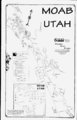
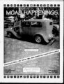
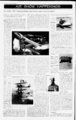
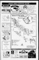
Show HIAIWPBIMIIBIflm Moab Area 3ike Trails C Info Courtesy Moab Bike Patrol The Moab area has many mountain bike trails of varying difficulty. Provided here is a subjective rating of the most popular trails. To ride these trails, you should obtain a map andor guidebook. Avoid injury, exhaustion, disgust and fatigue by picking a trail that you are up for today. The ratings are relative; what may be a difficult trail elsewhere may be considered easy in Moab. All of the trails listed have outstanding scenery and are worthwhile destinations. The trails are listed in order of perceived difficulty, with a rating of 4 signifying the most difficult. Also note that there are many other trails not listed in this article. To find out more about these trails and others, contact one of Moabs bike shops, visit the Information Center, browse through a bookstore, or purchase a few maps. Also, asking the locals can clue you in to routes. You may even meet a few people to ride with. Some general tips for riding on all trails here in Moab include taking plenty of water. If youre not from our dry climate, you need to really increase your H2O intake. Residents of Moab should be drinking a gallon of water a day, without exercising. If youre visiting from a more moist area, and arc here to engage in physical activity and plenty of mountain biking, drink water everywhere you go. Never let yourself get thirsty. By the time your body feels physical thirst, the dehydration damage may have already been done, and everything you drink subsequently will go not to maintaining your fluid levels, but to trying to replace them. Another tip is to watch out for our fragile environment. A desert ecosystem is extremely delicate. By now you have probably heard about cryptogamic soils. If you havent, its the thin black crust that tops the desert floor in some areas. Never walk on this and never ride your bike on it. It takes -seriously - longer than a human lifetime to create or replace this soil. Its what allows the few desert plants that grow here to grasp the sandy soil. A final word of advice: have fun and enjoy your ride. Mountain biking and Moab go hand in hand, and we wish you a safe, scenic ride and a fun night on the town afterward. lulf-nullio- RATING TRAIL 4 Slickrock Bike Trail constant elevation change; slickrock with short patches of sand; very steep pitches; technically and physically difficult - not for beginners; Sand Flats Recreation Area fee. 12.7 miles k; PorcupineRim one-wa- PritchettBack of Behind B'fTHE TIME WHITEMAN BEGIN Conquest of America the River rat had colonies oh every River in n. America- 3 the Rocks) (aka Kane Creek Canyon RimPrftchett CanyonBehlnd from trailhead near Highway 191 to Kane Creek Boulevard; 1500 foot descent with short, steep climbs; jeep trail with rocky surfaces, big ledges and some sand; fee to landowner at end of ride. 21 miles one-wa- y 3 Flat Pass (aka Steel Bender) including 6 miles on pavement; multiple ascents; low 4500 feet, high 5900 feet; jeep trail with 8 mile loop rocky ledges, stream cobble-- , some sand and multiple stream crossings. 2 Poison Spider Mesa to Little Arch from trailhead on Highway 279; 100 foot climb; jeep trail, large slickrock d area, sand and sediment; marked with wTite jeep stencils on rock; optional descent using Portal Trail single track is difficult and exposed. j i! Amasa Back (aka Cliff Hanger) 12 mile rock-studde- 3; miles ledges and from trailhead on Kane Creek Road; 1100 foot ascent; jeep trail with loose rock, 10 hard-packe- .sections. d Gemini Bridges ' . ' . .. , f J ' 2 . , at Highway 191 or 16 miles from trailhead on Highway 313 to trail-en- d from 191 to the Gemini Bridges; 1400 foot descent one-wa- y with a long, steep climb near end; 700 foot Highway from Highway 191; dirt road and jeep trail with rocky surface and ascent to the bridges as an ' some sand. . 14 miles one-wa- y Klondike Bluffs 1 , 6 miles to Arches National Park boundary from trailhead on Highway 191; 800 foot ascent: jeep trail with hard pack and slickrock; marked with dinosaur footprint stencils; avoid when wet. " Monitorand Merrimac 1 . 7.4 mile loop plus optional 6 mile to the Monitor and Merrimac buttes from trailhead near Highway 191; 700 loot ascent; jeep trail, slickrock and some sand; large, open slickrock riding areas; avoid ' when wet. ' : ; 1 - Hurrah Pass i from end of pavement on Kane Creek Road;' 900 foot ascent to Hurrah Pass with intermediate ascents; graded gravel and dirt road; ride may be shortened by starting farther along the Kane . Creek Road. 19.2 miles - Advice to Riders from the Moab 3ike Patrol containei. Eating at intervals providesd an oppoi tunny to rest and the energy needed to complete the ride. Check your hike frequently. Riding on Moab trails loosens headsets and puls maximum stress upon frames and components. Frequent inspections reduce the possibility of injury. Be prepared in case of an emergency. Dont venture into remote areas with nothing but a and shorts. Carry ;1 windhreaker, sunscreen, sunglasses, THE HISTOftY Of THE 4 ' !V - y 14.4 miles from trailhead on Sand Flats Road to Highway 128, 30.8 miles for entire loop; 900 foot climb from trailhead, then 3,000 foot descent; loose, rpeky jeep trail and singletrack; Sand Flats Recreation Area fee; plan for weather extremes due to higher elevation. ,f Survive and Thrive Wear a helmet. Most trails are very rocky. Even the best riders can get tired and make mistakes. Helmets can prevent or reduce the severity of head injuiies. Medical professionals say that the average cost of n treating a major head injuiy is over a dollars. Carry lots of drinking water and take high energy food. Even during colder months, after a lew hours, most riders start craving water. Take two large bike bottles and a reserve supply in a wuiter bladder or other i ife kit, map, matches or lighter, pump, patch kit, first-ai- d a good bike tool kit and extra food, water and clothing. Ride with someone else and stay together in case of problems. Discuss your situation calmly and make a plan to improve it. Dont panic. Have fun and learn about the special features of the area. Great trails are not the only reason Moab has become an international destination. Take time to enjoy the scenery, study ancient rock art, or marvel at the harmony of a cryptogamic soil garden. RIVER RAT ONE CULTURAL branch of the River rat ecCAMETHETAHOUS VOYAGE RAT THEY FOLLOWED Ml THESE AVER Aflf ) kki ! Q TRADE EVER WESTWARD on the example Were INHABITED MANDRAT5-WH- THE O 3ANKS OF THEVUSSOURI R. THEY WERE ALSO VERY LVCKY 11 |