| OCR Text |
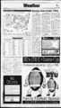
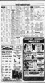
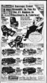
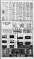
Show A Thursday, September 29, 1994 .The Daily Herald The Accu-Weath- Showers likely tonight, Friday forecast for noon, Friday, Sept. 30. er 60s UTAH Salt Lake, Ogden and Provo: Tonight and Friday showers and thunderstorms likely. Lows in the s to lower 50s. Highs near 70. Chance of rain 70 percent tonight and 60 percent on Friday. Northern Utah: Tonight and Friday showers and thunderstorms likely. Lows Highs near 70. Extended forecast, Saturday partly cloudy with a chance of showers and thunderstorms. Lows in the 40s to lower 50s. Highs Sunday partly cloudy with a slight chance of showers. Lows in the 40s to lower 50s. Highs in the 70s. Monday partly cloudy. Lows Highs in the 70s. Southern Utah: Tonight showers and thunderstorms likely. Lows Friday mostly cloudy with scattered showers and thunderstorms. Highs in the 70s and low 80s. Extended forecast, Saturday partly cloudy w ith a chance of showers and thunderstorms. Lows in the 40s to lower 50s. Highs Sunday partly cloudy with a slight chance of showers. Mainly east. Lows Highs in the lower 70s to mid-80Monday Highs partly cloudy. Lows mid-40- xebsTT 60s 45-5- 5. 70-7- 5. 45-5- JJT" 90s (l) Vj WARM STATIONARY Pressure H L HIGH LOW Via Associated 40-5- 90S FRONTS: COLD K 0 SHOWERS 1994 us EZ3 FLURRIES RAIN m m SNOW ICE Inc Accu-Weathe- r. ItH dD, PT. CLOUDY SUNNY 70-8- TempsratoGS Press Thursday Temperatures indicate previous day's high and overmght low to 8 a.m. EDT. Hi Lo Pre Otlk 48 .11 68 Albanv.S.Y. cdy Albuquerque 89 52 cdy Amanllo Anchorage Ashevilk Atlanta Atlantic City 94 57 52 34 clr clr l' ,- Detroit 71 47 97 64 67 44 89 53 72 45 63 49 Duiuth 56 35 97 fil 44 31 .06 .19 cdy cdv clr cdy clr cdv cdv clr 74 49 83 64 cii 76 50 clr El Paso Fairbanks Fargo Flagstaff Grand Rapids Great Fait Austin 92 61 cdy Greensboro.N'.C. Baltimore 74 53 74 51 Billings 54 48 Birmingham Bismarck 56 88 80 78 43 cdv Helena Honolulu Houston 82 86 clr m clr Hartford Spgfld 84 94 59 87 57 cdy cdy cdv cdv cdv Indianapolis Jackson.Miss. Jacksonville Juneau Kansas Citv Las Vegas" 69 45 90 60 clr clr 87 66 cdv '' J ' Boise Boston .01 75 56 Brownsville Buffalo 90 66 60 50 .45 Burlington. Vt Casper 69 53 .03 87 46 Charleston.S.C. 84 70 Iharleston.W.Va. 71 47 79 58 87 51 rh clr clr clr rn 65 45 cdv itncirinaU -Cleveland 71 44 63 51 T!umbiaiC. 82 56 clr cdv clr clr 1 Ctarlotte.N.C. "tleverne tlhicagi 67 Cfllumbus.Ohio 5. 45-6- 75-9- Concord.S.H. Dallas-F- t Worth Davton Denver Des Moines .33 44 67 49 78 48 59 44 80 42 75 53 cdv cdv cdv .21 .02 49 New Orleans New York City N'orfolk.Va. Oklahoma Citv 90 60 92 56 Omaha Orlando Philadelphia Phoenix Pittsburgh PortlaniMaine PortlaniOre. Providence 75 46 84 72 74 52 103 76 62 49 .05 .06 72 54 82 61 .10 clr cdv clr clr clr cdv cdv .24 cfr cdv cfr cdv 66 53 61 76 51 Raleigh-Durha- 78 52 cdv Rapid Citv 92 55 cdy cdy cdv Reno Richmond 72 51 it 53 Sacramento 79 56 St Louis Salt Lake Citv San Antonio 75 50 91 62 94 59 San Diego San Francisco Santa Fe Seattle Shreveport Sioux Falls 88 70 71 60 87 47 75 60 96 63 74 46 Spokane 84 55 cdv clr rn .12 clr clr clr clr .01 rn cdv cfr cfr .87 cdv cdv cfr cdv cdv Svracuse 62 51 .09 cdv 83 76 72 57 86 57 75 53 .08 cdv clr cfr cfr 50 32 51 cdv clr 99 83 cdv Little Rock Los Angeles LouisviDe Lubbock 87 63 90 74 74 47 98 62 Memphis Miami Beach 89 59 clr clr clr clr clr 83 71 3.89 81 75 cdv cdy clr 76 .02 Nashville Ptrsbe cdy Tampa-S- t Washington.D.C. Wichita Wilmington.Del. Midland-Odess- 97 58 clr Milwaukee 65 47 MplsSt Paul 63 43 cdy cdy 5. s. Press By The Associated 5. 5. 45-5- CLOUDY cdv mountains and west with widespread showers and mainly evening thunderstorms. Partly cloudy east. Lows 35 to 50 except 25 to 35 mountains. Friday mostly cloudy and w indy with scattered showers and afternoon thunderstorms mountains west and south. Partly cloudy northeast. NEVADA By The Associated Press 50s Bands separate high temperature zones for the day. 0. Northern and central Nevada: Tonight partly cloudy west w ith a slight chance of showers. Scattered showers east. Lows in the upper 30s to upper 40s. Friday mostly sunny and warmer west highs in the mid- - to upper 70s. Partly cloudy east with a chance of showers and afternoon thunderstorms. Highs lower 60s to WYOMING mid-70- s. Statewide: Tonight cloudy. Showers likely west and north scattered showers southeast. A few thunderstorms possible statewide. Snow above 9.000 feet. Lows in the 30s west, 40s east with some 20s in the mountains. Friday mostly cloudy with showers and a few thunderstorms. Clouds and showers decreasing from the west dur- Southern Nevada: Tonight partly cloudy. A slight chance of showers over the mountains. Lows s to Friday partly A cloudy. slight chance of showers over the mountains. Highs lower 80stomid-90s- . ARIZONA Statewide: Tonight scattered showers and a few thunderstorms north. Otherwise variable cloudiness. Breezy. Lows in lower 40s s mountains to deserts. Friday scattered showers and a few thunderstorms north decreasing from the west, otherwise mostly cloudy north, variable cloudiness south. Cooler. Locally windy. s mountains to the Highs in deserts. 90s warmest upper COLORADO Statewide: Tonight cloudy mid-60- s. mid-50- ing the day. Highs in the mid-40- s s mountains. Highs elseto where in the 60s with a few low 70s east. WASHINGTON Western Washington: Tonight mostly cloudy. Lows 45 to 55. Friday partly sunny after morning low clouds. Slight chance of showers coast. Highs 60s to near 70. Eastern Washington: Tonight partly cloudy after slight chance of an evening shower southeast. mid-50- mid-70- mid-60- 0. Dixie: Tonight a good chance of showers and thunderstorms. Friday partly cloudy with a chance of showers and thunderstorms. IDAHO Northern Idaho: Tonight CAR most- mid-70- s. mid-60- s Idaho: Tonight showers and evening thunder-showeeast. Variable clouds with scattered showers west. Lows in s the to lower 50s. Friday showers likely east. Partly cloudy s to west. Highs in the Extended forecast, Saturday mostly sunny and warmer. Lows CHEVY FULL SIZE TRUCK OR BLAZER, SUBURAN 1984-8- 8 TOYOTA TRUCK OR 1982-9- 1 FORD RANGER TRUCK OR BRONCO 1980-8- 6 FORD FULL SIZE TRUCK OR BRONCO in the mid-30- s to mid-40- s. Highs in s II BRONCO 1989-9- 3 TOYOTA TRUCK OR 1986-9- 3 NISSAN HARDBODY TRUCK OR PATHFINDER VV mid-40- mid-70- s. s89 s99 .na-- va-s- i 1988-- 92 FULL SIZE CHEVY TRUCK OR BLAZER, SUBURBAN rs mid-60- TRUCK SPECIALS 1973-8- 6 and cooler. A chance of showers. Southern & 1987- - 93 FORD FULL SIZE TRUCK OR to Sunday mostly cloudy mid-70- s. mi ui ly cloudy. Isolated showers. Lows 45 to 55. Friday partly cloudy and cooler. Highs upper 60s to Extended forecast, Saturday partly cloudy with a slight chance of showers. Low s in the upper 30s and 40s. Highs in the t i VALUABLE COUPON tr X Y MOST INSURANCE COMPANIES I C f 9 USETHISC0UP0N FTWEBILLOUT II FOR UP TO OFF YOUR INSURANCE S 109 M29 s129 s149 s 169 s 189 2ffl (CM j deductible 'Restrictions apply 'Call tor details ALL QUALITY INSURANCE COMPANY APPROVED GLASS the 70s. Sunday partly cloudy. Slight chance of showers east. Clouds, fog cloak East, West coasts By The Associated Press Clouds and fog cloaked cities on the East and West coasts this morn-- , in?- - Southwest. From the Rockies to the Great clouds were Lakes, build to through the day. expected Storms were likely in the mountains, w ith highs in the 70s. The temperature hit 109 degrees at Lake Havasu City, Ariz., and at Imperial. Calif., for the nation's rain-beari- Cool, blustery winds were blowing from Canada into the U Great Lakes states and the North-east, where gusts up to 40 mph were expected. and showers were from the Great Lakes into fore--la- st England. in the Us were expected -- inTNew England, while tempera- tures were forecast to rise into the ; 60s across the Upper Midwest. . Sunny skies were likely from the -- Plains to the Southeast coast, with 'thunderstorms forecast for south-'er- n ;.J-iigh- temperatures rising into the 90s south of Kansas City and into the s Florida. Highs in the 80s were likely across much of the Midwest, with Purchase one seat and get a child high Wednesday. qi Other reports at 5 a.m. EDT (atmospheric conditions not avail- iu lo in FREE yr. able for all cities): West: Albuquerque 62; Anchorage 37 fair: Boise 64 showers; Casper 49 fair; Fairbanks 33 cloudy; Great Falls 43: Honolulu 82 fair: Las Vegas 85 cloudv; Los Angeles 70 cloudy: Medford 58 cloudv; Pendleton 70 rain: Dr. J. Paul Clark and Dr. Dana A. Anderson are now accepting maternity patients at The Utah Medical Group. Dr. Clark and Dr. Anderson are family practitioners with experience in maternity care. Both doctors are Kurd certified by The American Board of Family Practice, and are diploma tos of The National Board of Medical Examiners. When it comos to family matters, call for an appoint- ment with Dr. Clark or Dr. Andersen at The Utah Medical Group in Jamestown Square, 3585 N. University Ave., Suite 150, in Provo. Office hours are 8:30 a.m. to 5:00 p.m. For information All calls are assessed and appointments, call medical bv qualified personnel. 377-103- 5. UTAH MEDICAL GROUP Family Football Specia Wi WMW m Bay i i iiai I i3 I I 3 |