| OCR Text |
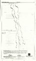
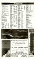
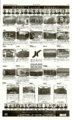
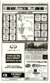
Show The Park Record B-2 Wed/Thurs/Fri, January 12-14, 2005 AccuWeather.com ALMANAC Wednesday, January 12, 2005 REGIONAL FORECAST FIVE DAY FORECAST FOR PARK CITY Park City statistics for the week ending January 10 WEDNESDAY THURSDAY FRIDAY SATURDAY SUNDAY Mostly cloudy with snow showers Mostly cloudy v/ith snow showers possible Intervals of clouds and sunshine Partly sunny A blend of sun and clouds Winds: WNW 8-16 mph Winds: NW 8-16 mph Winds: NW 8-16 mph Temperatures: High for the week 41° Low for the week -5° Normal high 33° Normal low 13° Average temperature 24.5° Normal average temperature .... 22.8° Precipitation (inches): Total for the week 2.66" Total for month thru January 10 3.06" Total for the year 3.06" Normal for the month 0.89" Normal for the year 0.89" % of normal this month 344% .'/ % of normal this year 344% Wednesday Thursday City Hi Lo W Aspen 26 9 sn Boulder 36 15 sf 23 -8 sn Butte Colorado Springs42 15 sf Bko By Evanston Flagstaff Gallup Grand Canyon Grand Junction Gunnison Idaho Falls Jackson Hole SUN AND MOON Sunset 5:20 p.m. 5:21 p.m. 5:22 p.m. 5:24 p.m. .. .. .. .. Missoula Ogden Page Pocatello Provo Pueblo Reno -Flexburg St. George Salt Lake City Spokane Sun Valley jShown is Wednesday's Tahoe weather. Temperatures are Twin Falls Wednesday's highs and Yellowstone Wednesday night's lows. Moonrise Moonset Wednesday 9:53 a.m. . .. 8:16 p.m. Thursday .. 10:22 a.m. . .. 9:32 p.m.v i ' Friday 10:48 a.m. . 10:44 p . m l " '*' Saturday .... 11:10a.m. . 11:52 p.m.* MOON PHASES First Full Last New Grand Canyon 35/7 Jan 16 Feb 2 Feb 8 V V NATIONAL CITIES City Albany Anchorage Atlanta Atlantic Ctty Boston Buffalo Charlotte Chicago Cincinnati Cleveland Columbus, OH Dallas "'.«-=-, Wednesday Hi Lo W 37 34 i 12 9 c 70 54 pc 56 49 r 38 36 sn 48 47 r 72 54 pc 50 28 r 68 52 sh 55 54 r 64 56 sh 22 38 t 14' ROAD CONDITIONS REGIONAL CITIES High Wednesday 2, low . HighThursday 1, low, } High Friday 2, low ' / , , 0-2, Low; 3-5, Moderate; 6-7. High; , v/ ';•' 8-10, Very High; 11+, Extreme •" :'f Values indicate the exposure to the sun£ V ultraviolet rays. ' } Sunrise 7:49 a.m. . 7:49 a.m. . 7:48 a.m. 7:48 a.m. . Winds: ENE 10-20 mph 32°/20° [iW>WW*M!ld:iWllilil; Wednesday Thursday .. .. Friday .. Saturday .... .. NE 10-20 mph The unsettled weather will start to wind down on Wednesday. Snow showers will taper off to flurries in the afternoon as a storm heads east of the Rockies. Over the next several days, high pressure will keep the region dry with some sunshine each day. Temperatures will be near or slightly below average. 31 33 21 36 38 35 38 27 23 18 55 25 34 44 30 35 42 42 22 52 35 24 23 36 31 15 10 6 10 14 8 7 18 0 14 8 31 6 21 27 22 21 14 19 12 28 23 8 6 9 21 -2 DC pc Sf s sf s sf sn sf sf s sn sf pc sf sf sf s sf pc sf sf sf s si sf Hi Lo W 25 1 sf 33 12 pc 4-20 sf 36 12 pc 31 8 pc 35 4 s 22 3 sf 43 12 s 42 s 41 s 36 12 c 24 -5 sf 18 0 sf 15 -8 sf 53 8 31 42 25 33 44 39 16 51 33 14 18 38 28 31 -1 18 27 7 18 9 15 0 29 19 0 -6 6 16 7-13 Interstate 80: Snow showers will gradually diminish on Wednesday, leading to improving road conditions. US-40: A storm will head east of the area on Wednesday; snow will taper off to flurries and roads will be mainly wet. TRAVELERS FORECAST Snow shower activity is expected to diminish across the region on Wednesday as a storm departs to the east. Dry weather will be the rule Thursday and Friday with some sunshine. s st sf s sf sf pc s sf pc sf pc pc s pc sf WEATHER HISTORY A cold snap in the Pacific Northwest spread eastward on Jan. 12, 1888. spawning the "Blizzard of '88." The storm affected an area from northern Texas to the Dakotas and killed 200 people. All forecasts and maps provided by AccuWeather, Inc. ©2005 WORLD CITIES Thursday Hi Lo W 54 35 sh 22 18 sn 64 44 t 64 44 sh 56 42 sh 56 22 r 66 48 t 30 2 sf 52 20 r 56 16 r 60 16 r 53 29 s 34 10 pc Wednesday Thursday City Des Moines Detroit Dover Houston Honolulu Las Vegas Los Angeles Miami Minneapolis Nags Head New Orleans New York Norfolk Hi Lo W 44 8 r 52 42 r 57 50 r 78 48 sh 78 63 s 56 34 s 60 46 s 80 71 sh 30 0 sn 66 54 pc 78 62 sh 45 42 r 67 57 pc Hi Lo W 12 -8 pc 46 14 r 69 42 sh 60 38 pc 78 64 pc 52 34 s 67 47 s 80 71 sh 3 -15 pc 70 53 t 65 46 r 60 41 sh 77- 50. Wednesday Thursday City Hi Lo W Hi Lo W Oklahoma City 60 28 t 44 16 pc Orlando 80 64 pc 80 64 sh Philadelphia 54 50 r 68 43 sh Phoenix 60 37 s 60 42 s Pittsburgh 66 54 sh 62 24 r Providence 43 38 r 59 42 sh St. Louis 64 35 r 39 9 sf San Antonio 76 45 pc 59 35 s San Diego 61 47 pc 63 47 s San Francisco 54 41 s 54 42 s Seattle 39 30 sf 36 22 pc Tampa., , . . . . . 80 6,4 P C . , 78 66 sh Washington, DC .62-52 r. „., . 7 0 . 4 0 . . ( • • City Auckland Bangkok Barbados Beijing Berlin Buenos Aires Dublin Frankfurt Hong Kong Jerusalem London Montreal Wednesday Hi Lo W 69 56 pc 90 72 pc 83 68 t 37 18 s 51 92 43 46 63 52 46 34 37 66 36 34 53 41 39 31 City Moscow Oslo Paris Rio de Janeiro Rome San Juan Seoul Sydney Tokyo Toronto Warsaw Zurich Wednesday Thursday Hi Lo 33 22 36 29 49 42 82 69 54 45 82 72 26 9 90 72 44 26 48 44 47 36 45 34 Hi 34 41 43 80 50 82 28 95 43 48 39 W pc sn r s sh s s pc r sh r Lo W 25 sn 28 pc 30 pc 68 s 39 c 72 sh 12 pc 79 s 32 s 18 r 28 c 35 24 c Wealrier (W): s-sunny1 pi'-partly ctou'dy, c-cloudy, 'sh-showers. t-thunderslorms', r-rain, 6f-snow Hurries, en-snow,' I-lea BUFF PARK MEADOWS REMODEL The Park Record. 7 7 0 RED MAPLE COURT BEAUTIFULLY FINISHED 3 BED, 2 BATH HOAAE, DELUXE TOUCHES, GRANITE, TRAVERTINE, H A N D SCRAPED H A R D W O O D FLOORS, RADIANT FLOOR HEAT I N KITCHEI I A N D BATHS, JETTED T U B , r r sh r r s sh sn Thursday Hi Lo W 70 59 s 91 73 s 84 67 c 34 12 pc 39 30 c 83 63 t 46 41 pc 35 25 c 58 48 sh 55 45 s 45 36 pc 48 26 sh £.•:..*• v > Reprints LANDSCAPED W I T H S T O N E PATIO, S U N N Y R E D W O O D DECK, H O T TUB, 2 CAR G A R A G E , ALL ON A QUIET, SAFE, HIGHLY DESIRABLE C U L D E S A C LOCATION. The Park Record introduces its new online photo reprint service '•'f, NEWLY REMODELED FALL 2004 MUST SEE INSIDE TO APPRECIATE! > CLICK....IT'S YOURS!! Prints, Mugs, Mousepads, T-shirts, Magnets $549,000 CALL FOR AN APPOINTMENT 435-513-1254 Goto www.parkrecord. com and select: photo reprints or call for information 649-9014 Order reprints of Park Record photos taken by our award winning staff photographers Scott Sine and Grayson West |