| OCR Text |
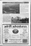
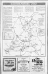
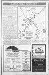
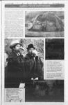
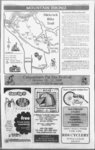
Show Get Off Your Seat And On Your Feet fantastic shapes. Climbers occasionally scale these mudstone towers (be cautious of hiking directly below a climber!). Note: This trail has a western exposure and can be exceptionally hot on summer afternoons. Mountain bikes are not allowed on this trail. Moab is blessed with a wide variety of outdoor activities that can be done in or near the vicinity of the center of town. One of these is hiking. It is possible to start from the center of Moab and take some very interesting, short hikes or a few minutes drive in any direction will put you at a trailhead of your choosing. The Grand County Travel Council and the BLM have brochures available describing many of these trails in great detail and these brochures are available at the Moab Information Center. We are just giving you a peek at the variety of hikes. As with all activities in the Southwest, we caution you to take plenty of w'ater and let someone know where you have gone. Fisher Towers Trail: Trailhead Location: Off Utah Scenic Byway 128. At 21 miles east of the Utah 128US 191 junction, turn right and go 2.2 miles on an improved dirt road to a parking lot. to ridge at trails Length of Hike: 2.2 miles one-wa- y tnd; allow 4 hours round trip. Type of Hike: Constructed trail. Area Attractions: Close up views of the Fisher Towers and Onion Creek area. Distant views include the Colorado River, Castle Valley, Fisher Mesa, and the Book Cliffs. Route Description: From the parking lot (please sign in at register box), the trail goes down a short set of steps and then runs to the left out onto a small slickrock-covere- d ridge. Follow the ridge away from the main old road bed the trail is fairly well defined if you watch for the cairns along the way. This 1.5 mile hike will reward you with a view of the Corona Arch and the nearby Bow Tie Arch. Portal Overlook Trail: Also on Hwy 279 is another .5 mile hike that will give you a panoramic view of the Moab Valley, the La Sal mountains, the Colorado River and the portal on the opposite side of the River. This trail is a little more rugged than 1 the Corona Arch trail. Negro Bill Canyon: This one is cliffs until just after it narrows and then go left down into the 4 , i F-- j. miles south of town and follow Angel Rock Road to Rimrock Lane, a right turn and drive to the parking lot. This is a 2 mile hike up a scries of switchbacks, against the Moab Rim. The name Hidden Valley comes from a broad shelf that you will find partway up the trail. You will end up on top with a panoiamic view of Moab and Spanish Valley. Corona Arch Trail: Take Utah Hvvy 279 (Potash Road) and go 10 miles west. From the paiking lot you will find the tiailhead near the railroad. Follow ins an Hidden Valley Trail: Drive and then begins to wind ' directly beneath the Fisher Towers. After swinging around the largest tower. The Titan, the trail ascends and ends on a ridge with a panoramic view. The Fisher Towers are composed of Moenkopi and Cutler sandstones, and have eroded into many 3 favorite of many of the local people. Up the River Road (Utah 128) about 3 miles east of the junction with US 9 there is a marked parking lot. The major feature of this hike is Morning Glory Bridge, which is about 2 miles up the trail. Allow about 4 hours for a round trip. Morning Glory Bridge is the 6th largest (243 feet) span in the United States. 1 ravine through a small cut on the left side of the ridge. From the bottom of the ravine the trail, heads steeply up a 1 These few suggestions are only a few of the multitude of hiking trails that can be accessed from Moab. Many of the Jeep and Bicycle trails described in other local Brochures are also suitable for hiking. The La Sal Mountains have a number of day hikes . available to the back country. ,, - Cany onlands e ' 13 (MQ i!S tv JBsJsJsagRSsl ffliDEJSIr tiiTtiVtsti vaUPTHit fiSffiv fJERU i$J '1H3 ijlstv 'SEWS 1? 'SEELS v!fUii K Camping Equipment Hiking Gear, Fishing tackle Horse Tack . a -- vrafe tayasEi -- 'iuiKvn as vnwntitEm (jisjm-- a l cl O: fcHats & Gloves v Cast Iron Cookware V Game Licenses ms 'tsgptiami. i&umr!, tiLijn&issaas!' .nwat r.v asyr5 ife) ihWiwJ' .ito'i Ml !JliWrU f !' ? i .ite-rr- . Utfr ..(!&: -- .fculfe' SUWHi'bj . iU lift. ilUM &? wJtj thi . v t Full Store & Grill Camping Facilities v (Millers Shopping Center) Enjoy the drive south of Moab on Highway 191. Take Newspaper Rock turnoff at Highway 2 1L (435), 2595731 Continue out to the Needles District of Canyonlands National Park (about 34 miles) . for more information call our cellular phone Jh) Y In the Heart of Canyon Country at Canyonlands National Park Needles District Large Groups - Call Ahead for Meal Reservations 702 South Main ' mi?' M Hours 8:00 a.m. to 7 :00 p.m. (Subject to Change) Please Call For Information ... --licytsisflEr. asimui -- Outpost 2- - sHuntingSupplies m 'itatsKBjii Eta iutsie- & dl -- ( Open 9:00 a.m. to 6:00 p.m. Sundays 12:30 - 6:00 pm.'. (435) 979-400- 7 |