| OCR Text |
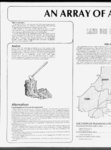
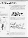
Show AN A MAY OF Other Considerations In addition to the five planning issues, the BLM must designate public vehicle use. Decisions must be made permitting lands for vehicle use while protecting other multiple resource values. Other aspects of the plan consider identifying areas of Critical Environmental Concern, administration of the fire management program, and managing a small wild horse herd near Chloride Canyon. The next major step in the information phase of the process involved completing inventories on the resource identified in the issues. Intensive range and wildlife inventories were completed in 1981 and 1982. Based upon these inventories and existing information, the Management Situation Analysis (MSA) considered current and future management options and was completed in 1983. off-roa- off-roa- d d THEA Analysis in The planning area is lo 1,071,000 acres of public lands. The planning units are pre two broad valleys of the Colorado Plateau drained by the Sex The vegetation in the planning area is quite varied, from s white fir in the Mineral Mountains. Elevations range from 5( Mountains, with percipitation ranging from 8 inches to over ; Resources in the planning area include geothermal reserve Kolob, John's Valley, and Alton coal fields to major iron dep for cattle, sheep and a wide variety of wildlife species. The predominate resource users include livestock oper; major power corridors exist with several additional corrid corridors bring tourists and commerce to the general region. the formulation of alternatives and the analysis of the environmental effects was initiated, culminating with the publication of the Draft EIS in May of 1984. Within the Draft four alternatives were explored including the BLMs preferred alternative. In essence, the four alternatives 1983, Early represent four lists of management actions which could guide management of the public lands. The alternatives explore a range of choices ranging from commodity production to maximum protection of sensitive resources. A brief discussion of the alternatives follows: Alternatives Continuation of Present Management the No Action" alternative. This alternative addresses the level of goods and services which could be produced, in the future if current management practices remained unchanged. Personnel and funding would remain the same, and new projects would not be authorized. Under this alternative existing trends in resource condition would remain the same and no actions would be funded to modify downward resource conditions. Nearly 50 percent of the .Simply stated, this alternative is could lead to a reduction in forage available range would remain in poor condition. These situations and to livestock and wildlife. Nearly 15 percent of the fisheries habitat is in declining condition class. 26,000 acres would remain in critical erosion would continue to be authorized on y Lands would be offered for public sale and the corridors and may delay of a lead could This to basis. proliferation a processing applications. and Oil, gas and geothermal resources would continue to be leased under existing categories in currently unprotected stipulations, resulting in the potential for significant resource damage coal sensitive resource areas. Coal would not be made available on 37,000 acres of potential development areas. witnin oU At the current rates of harvest the accessible woodland resources would be depleated 25 within years. miles of Cedar City vehicles use would not be managed and all public lands would At current funding, remain open to ORV use. No management actions or changes designed specifically to resolve planning issues would be rights-of-wa- case-by-ca- rights-ofwv- se ay , . , off-ro- ad proposed. . . , . LOCATION OF PLANNING UNI BEAVER RIVER RESOURCE AREA Beaver Planning Unit Cedar Planning Unit KANAB RESOURCE AREA Garfield Planning Unit ESCALANTE RESOURCE AREA Antimony Planning Unit |