| OCR Text |
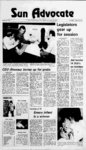
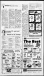
Show prrr rrP" ri" ' yr' m Wednesday, January 5, 1983 Sun Advocate, Price, Utah 3A Ice blocks river - ' 4 1 2 High 3 ii ,f waters pose threat to Carbonville trailers ZZ2i?r'' - CARBONVILLE An in- crease in the amount of water released from Scofield Reservoir threatened to flood a trailer court here Monday when ice blocked the Price River. Cold weather and a need to lower the level of the reservoir combine to create the flood danger in the Country Estates Trailer Court. The water rose to within inches of some trailers on &?' S. ''4 the west end of the court. Ive lived here five years and never seen anything like this, said Terry Houser, one of the residents whose trailer was threatened by the high water. The problem was caused n when water released from Scofield Reservoir froze, plugging the river channel in the north Carbonville area. As soon as the problem was noticed by the residents of the area, of the Scofield Reservoir Board cut the water flow from the reservoir to the lowest possible levels. ice-lade- of-fic- Water from the ice-choke- Price River d flooded a field and endangered trailer houses at the Country Estates Trailer Court Monday. The problem occurred when an increased flow of water was released from Scofield Reservoir and was blocked by ice in the Carbonville area. Snowmelt, rains make for wet '82 Snowmelt that continued through July, followed by g rains in the Wasatch basin in September, contributed to an unusually wet 1982 water year in Utah, acrecord-breakin- cording to the U.S. Geological Survey. The water year used by hydrologists runs from Oct. 1 of one year through Sept. 30 of the following year. It is designed to coincide with the growing season and to begin and end during a period of generally low streamflows. e streamflows on five of the states major streams contributed to increased reservoir storage in the Colorado River system above Glen Canyon Dam and a significant rise in the level of the Great Salt Lake. 9 storm that A Sept. dumped up to 3.72 inches of rain in the Salt Lake City area and greater amounts in nearby mountains was termed a meterological event by the U.S. Weather Service, meaning that a storm of that magnitude has a chance of occurring once every 100 years, or a one percent chance of occurring in any given year. The storm did not produce any Above-averag- 25-2- 100-ye- ar accompanying 100-ye- ar floods, but it did cause a record high flow of 2,800 cubic feet per second (cfs), or about 1.3 million gallons per minute (gpm) for the combined Photo by Stevo H diner This is the first time that something like this has ever said Lyle Bryner, happened, of the Scofield Reservoir Board. When we released the water it brought a lot of ice with it down the river and when it got to the slow part of the river around Carbonville president it froze. The water flow from the reservoir was increased to 65 cubic feet per second to lower the level so it can accommodate which is the spring of 140 be to percent expected normal, Bryner said. By comparison, the normal summer flow from the reservoir is run-of- f, usually between 300 and cubic feet per second. 400 The level of the reservoir is at acre feet and must be lowered to 40,000 acre feet to prevent filling it to capacity, thus losing one of the reservoirs functions of controlling floods. In order to lower the reservoir 55,000 to that level, Bryner said the out flow will have to be held to at least 100 cubic feet per second until spring. For right now, however, the flow will be held down to 15 cubic feet per second to prevent the river from overflowing its banks. The flow will be slowly increased until it reaches 100 cubic feet per second, Bryner said. If we dont get the level down by this spring it will jeopardize homes, railroad tracks, roads everything near the river will be threatened, Bryner said. One thing that worries Dave Rowley, Price River commissioner, is the danger of children playing on thin ice in the river near the north Carbonville area. Parents need to warn their children that even though the ice looks solid it is thin in spots and the water is up to four feet deep in spots, he said. JR. TURTLENECKS discharge of the Jordan River and the Surplus Canal in Salt Lake City Sept. 26. The combined watercourses discharge into Great Salt Lake at the lakes southeastern shore and helped boost the September level of the lakes surface to 4,200.2 feet above sea level, which was two feet higher than the lakes level at the end of the 1981 Reg. $9 water year. ALL The U.S. Geological Survey monitors the quantity and quality of the nations surface and ground waters. Working in cooperation with other federal, state and local agencies, the USGS Water Resources Division district office in Salt Lake City compiled the following information on streamflows, reservoir contents and ground-wate- r levels in Utah for the water year that ended Sept. 30. Green River at Green River had an average flow of 5,936 cfs (3.8 billion gpd), 6 percent above normal for the 88 years that records have been kept there. The highest daily flow of the year on the Green River at Green River was 20,000 cfs (12.9 billion gpd) May 8, and the low COATS O off LADIES COORDINATES flow was 990 cfs (640 million gpd) Dec. 31,1981. off Great Salt Lake began the water year with a surface elevation of 4,198.2 feet above sea level; fluctuated somewhat throughout the summer months, but generally rose and finished the year at 4,200.2 feet. 1982 MOON BOOTS Inventory Reduction off FASHION Jeans & Cords LEVI Saddlecut Denim 28 pair only reg. $21 .00 Price Store Only! On Fall and Winter Merchandise 55 East Main, Price 26 East Main, Castle Dale Price Store Open til 8 p.m. every Friday |