| OCR Text |
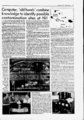
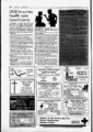
Show June 30, T994 Computer, 'old hands' combine knowledge to identify possible contamination sites at Hill An information system that combines the power of a computer with the visual familiarity of a map is helping environmental engineers seek out possible areas of hazardous waste contamination at Hill AFB. Called a Geographic Information System, or GIS, this computer uses a sophisticated data base to link information to specific geographic locations. Environmental engineers at the base's Environmental Management Directorate are using the GIS to help them with an investigation comprising almost 4,400 s acres of the base's area. The investigation, known as the North Area Preliminary Assessment, is part of Hill's effort to discover and clean up all hazardous waste sites at the base. "We are looking for evidence that would indicate a possible release of hazardous material into the environment," said Capt. Gary Chesley, the engineer heading the investigation. Like all preliminary assessments performed at Air. Force installations, the North Area PA is primarily an information-gatherin- g endeavor. Currently, contractors hired by Hill are thoroughly searching any existing records for any signs of hazardous waste usage or disposal. These records include maps, architectural drawings, photographs, inventories and any other existing records that may provide a clue y to the activities at a building or area. also is Chesley tapping into one of Hill's most valuable reservoirs of information its people. "We are talking with long-tim-e and retired Hill workers to" find out what they know. We have found that those .who worked in these areas can tell us more about what happened than any written record could,". Chesley said. in- In addition to records searches, limited e two-third- day-to-da- on-sit- This aerial photograph of the West spections will be conducted. "This usually means we go out and look at the building to see where floor drains are located or out to a site to see if there is any visual evidence of contamination," Chesley said. Chesley said he hopes all the information gathered will provide engineers a clearer picture of the types of activities that have occurred during the base's years of existence. That's where the GIS comes in, to provide engineers that picture of when and where these activities happened. "The GIS is simply a sophisticated computer data base linked to a map," said GIS engineer Mark Holt. "Each piece of information we get is entered into the computer and linked to its corresponding location on a map, such as a building," Holt said. "From there, we use the power of the computer to help us analyze the information." And compared to old methods of gathering and analyzing information, the GIS is a truly powerful tool. Data can be analyzed in dozens of ways. For example, if someone wanted to know all the activities that have occurred at a certain building, the computer would kick out a long list of every type of job ever performed at that building. Or, you could narrow the search to all activities involving methylene chloride that occurred before 1975. Or, you could ask the computer to show you all buildings on base that used methylene chloride before 1975. The computer can even turn back the hands of time by drawing a map of how the base looked in 1975. And that's just scratching the surface of its potential, Holt said. GIS information can also be overlaid onto aerial photographs of the base, giving engineers a more realistic view of the area. For example, the computer 70-pl- ' '? Area is overlaid with building numbers. The Environmental - ' 3 t Oprabk UnM 4 North Area Preliminary Q Assessment JOpmbteUnKS Hill OpMtk Air Force Base Information System, or GIS, generat- ed this map based upon information k. IS) (1 li a - If II r f;. I I """"" . 7 r - ? t OptnblaUnHt . Ofrab(e Unit i OpcrebteUnit) The North Area Preliminary Assessment encompasses the northern and eastern sections of the base. Investigators are searching for possible hazardous waste sites. Operable Units are areas where hazardous waste contamination has already been found. Detailed investigations are currently going on at all Operable Units. can zoom into a specific area and print an aerial view of the site complete with street names, building numbers, surface elevation and groundwater depth. comThe muscle behind the GIS is a UNIX-base- d puter system that includes 1.8 gigabytes of storage drive, a space, a large digitizing table, a flatbed scanner, a laser printer and a pen plotter for drawing the large maps and drawings generated by the GIS. In addition to the North Area PA, the GIS is being used at other locations on base to assist engineers with characterizing hazardous waste sites currently being investigated. Years of study have produced hundreds of thousands of pieces of data in the form of sampling information, geologic logs, topographic surveys, facility maps and real estate information from surrounding communities. While gathering the information is easy, entering the information into the computer is much more difficult. According to Holt, the data base currently contains more than 350,000 individual records, but that accounts for only about half of the information available. Hill has hired a contractor to enter historical information into the data base. Eventually, project managers will be able to pull up and use information on a specific site with their desktop computer. "The GIS will provide us with the most information on our sites," said Steve Hicken, an environmental engineer managing Operable Units 6 and 7. "We will be able to pull up the latest groundwater sampling information right at our desks. That will tell us what types of contaminants are in the water, how much is there and where they're moving," he said. "This information will help us make decisions on what methods will be most effective." With the help of the GIS, Chesley said he plans to have the North Area PA finished in April. "With the North Area PA completed, we will have a very detailed history of hazardous waste usage and disposal at Hill. We hope this will help us identify all the sites that need to be cleaned up." The preliminary assessment is the first step in the Superfund cleanup process. Once the PA is complete, engineers will then determine which areas merit further investigation. From there a site inspection will take place. Groundwater and soil samples will be tested to determine if any contamination exists at the suspected sites. If contamination is found, the site is moved into the next phase of the Super-fun- d cleanup process, the remedial investigation. CD-RO- : --. - .i-- K Just checking - UnH p"bl,Un. up-to-da- Management Directorate's Geographic entered into a large data base. The GIS could also overlay a topographic contour map, a water table elevation map or dozens of other combinations of OpanbteUnltt us " ' 7 Hilltop Times 1 L. Brad Maulding (photo on right) and Bron-so- n Hawley (left side of photo on left), Utah Department of Environmental Quality, check operations at the Hazardous Waste Control Facility. The state does an annual inspection of the base in addition to spot checks throughout the year to ensure that the base is handling hazardous materials and waste in compliance with the Resource Conservation and Recovery Act. Improper procedures, including documentation and other records, could lead to enforcement actions by the state. In the photo at left, Darrell Bishop, Hazardous Waste Control Facility manager, and Blair Armstrong, chief, Hazardous Materials Division, Environmental Management Directorate, talk with Hawley about Hill's waste oil handling procedures. i t.;1 o te |