| OCR Text |
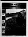
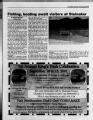
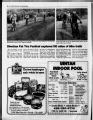
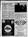
Show Fall 2000 Discover Dinosaurland 9 Elkhorn Loop takes in many High Uinta Lakes This tour will take you into the High Uintas. You will have an opportunity to see the multiple uses of the forest lands. Cattle grazing, logging and recreational pursuits all play a part in the story of the Uintas. The Elkhorn Loop road is not paved and can be a bit rough in some places, but it can usually be driven by car from about July through September. Total distance is 94miles. Plan on four hours of driving time, using the rest of the day for other activities of interest Hiking, stream or lake fishing, hunting and photography top the list of things to do. At the higher elevations, weather conditions con-ditions can change quickly. It never hurts to have rain gear and a coat handy. Take lunch with you. There are no services available on the mountain. Starting point for the trip is at L&L Ford,' where U.S. Highway 40 turns east and heads out of Roosevelt. There is a traffic light. A nursery nurs-ery is on the northeast corner of the intersection. inter-section. On Highway 40 east go six miles. Turn left on the Whiterocks Road, just Quality Since 1935 J Serving the Uintah Basin for 66 Years! i H-l QjQIlDCrilZ? ffc Simple Repairs to Major Complete Body Shop FenQer Benders to near Totals', from estimate of damage to "Out the door like newl" Overhauls with mechanics certified In: Engine Electronics Transmissions & Transaxles Carbu ration & Fuel Injection Engine Repair & Overhaul -Ford's S3DS on site SERVICE BAY DIAGNOSTIC SYSTEM "RV's & Motor Homes Welcome" New & Used Cars & Trucks 3 V Nine Mile Canyon is known for its secluded beauty pass the school. Stay on it. You will pass through the reservation town of Whiterocks. 20.4 miles. The Whiterocks fish hatchery is on the left Visitors are welcome. As you head north, follow the signs to the Elkhorn Loop, 26.2 miles. The Elkhorn guard station. Pavement ends at 35.3 miles. Stay to the right The road to the Whiterocks Canyon is pretty impressive. impres-sive. You will come to a logged over area that left quite a scar. The logging was to salvage wood from a freak wind that blew the trees down. 50.4 miles. Park above the stream. Don't try to drive through the water unless you are in a four wheel drive. The dam on the lake can be seen up the road. A foot bridge crosses the stream at 10,560 feet up to a natural lake. It was enlarged for irrigation purposes by the civilian conservation corps. In the basin Chepeta lies in are six other lakes. The WTiiterocks River flows south east through the me'adow. In the early 1900s settlers of the Uintah Basin didn't travel along Highway 40 from the Wasatch Front or on Highway 191 from Price, but eager homesteaders used an Indian trail built into a road by an Army unit That road, referred to by early scalers as "the lifeline of the Uintah Basin," is what is now called Nine Mile Road within historic his-toric Nine Mile Canyon. The all-black 9th U.S. Cavalry carved out the 78 mile road between Myton and Price by following an authentic Fremont Indian trail. The unit's work ended in Ft Duchesne on the Uintah frontier in 1886. The road not only brought over 15,000 of the area's settlers, but also served as the main line for cargo and mail and linked eastern Utah with Price and other communities. commu-nities. Evidence of rich history abounds along side the Nine Mile Road and within Nine Mile Canon. Among other things, signs of The Wells' hotelfacilities, stage stations, settler cabins and a telegraph wire line, still can be seen today. Nine Mile and its side canyons are famous world-wide and comprise one of the finest Indian rock art galleries in the world. Petroglyphs and pictographs depict the era of the Fremont Indians, who lived in the area for a 1,000 year period ending about 1200 A.D., as well as the Ute Indians, who occupied the area from 1400 AD to historic times are dispersed throughout the area. The Nine Mile areas is very remote. Travelers need to be prepared with gas, water and food. The area is administered by the Bureau of Land Management. No developed camps sites exist in Nine Mile Canyon and no camping fee or permit is needed. Mountain biking enthusiasts can find dispersed jeep and hiking trails. A group of interested individuals and agencies from both Carbon and Duchesne Counties have formed a 9-Mile Coalition" to help protect the cultural resources and beauty of Nine Mile Canyon, while at the same time provide some of the visitor facility so badly needed need-ed there. H. Bert Jensen, Myton, is the coalition vice chairman and has taken a special interest in the canyon through hours of research and documentation. Several brochures map the Nine Mile area and its points of interest. Eagle Scout projects have numbered the hot spot for each location and have even built a short foot path for hikers and explorers. A monument at the head of Nine Mile Road, approximately 1.7 miles south of Highway 40 turnoff (1.5 miles west of Myton) marks the beginning of Nine Mile. ml 75 (,cij.' I ji M ft&nmxi) (?mqjp (Tnsiuian flteinn |