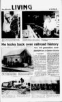
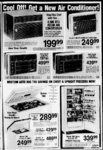
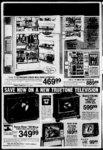
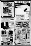
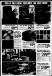
| OCR Text |
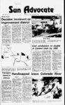
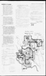
Show Resolution No. alng said (continued) line to the East thence South along said y line to the South y of 600 line South; thence South to a point on the present City Limits, said point also n tie North y line of inn! 700 South; thence the City along L i ts to the East Easterly in thence City Limit; a Northerly direction following the present City Limits to the Intersection y Sut;h Ynn line of 400 South; thence North to the South y line of 300 South; thence y Easterly along said line to the East y line of 600 East; thence Northerly along said y line to the center line of the Price Canal; thence Westerly along the center line of the Price Canal to the Intersection the West line of Section 16, T14S, R10E, Salt Lake Base and Meridian; thence South along said Section line to the point of BEGINNING. right-of-wa- right-of-wa- line of y Property owners may determine their estimated assessment by multiplying their total front footage by 12 of the width of the street fro" lip of gutter to lip of gutter nd then multiplying y Carbon Avenue; right-of-wa- right-of-wa- right-of-wa- right-of-wa- right-of-wa- right-of-wa- right-of-wa- right-of-wa- ZONE B at the Northwest corner of Section 21, T14S, R10E , Salt Lake Base and Meridian; thence South along the Section line to the North right-of-wa- y line of the Denver and Rio Grande Western Railroad; thence Southeasterly along said right-of-wa- y line to the West right-of-wa- y line of Carbon Avenue; thence Southerly line to the South along said right-of-wa- y right-of-wa- y line of 500 South; thence line to Westerly along said right-of-wa- y the Intersection with the present City Limits; thence in a Northwesterly direction following the courses and distances of the present City Limits to the Intersection with the South line of Section 17 T14-S- , R10E, Salt Lake Base and Meridian; thence East along said Section line to the point BEGINNING of BEGINNING. by $ 1.68. ZONE D at the Intersection of Meads Wash the North City Limits; thence in a Westerly direction following the courses and distances of the present City Limits to the Northwest corner of Price City Limits; thence in a Southerly direction following the courses and distances of the present City Limits to the center line of the Price Canal; thence in an Easterly direction along the center line of the Price Canal to the Intersection with the West line of Section 15 , T14S , R10E, Salt Lake Base and Meridian; thence North along said Section line to the line of 800 North; thence South right-of-wa- y line to the East along said right-of-wa- y Intersection with Meads Wash; thence in a the meanderings Northerly direction following of Meads Wash to the point of BEGINNING. BEGINNING and CONCRETE To DRIVE APPROACHES: excavate and install will Drive approaches and 12 be gutter or sidewalk foot wide drive approaches: installed total cost of wherever curb improvements are ESTIMATED The installed. COST improvements is estimated at $5,515,079 property owners' portion of the cost is estimated at $5,174,668 The City's portion of the cost is estimated The at $183,329 and other governmental entities' portion is estimated at $157,082. The estimated costs project to De assesse against the properties withii said District will be assessed as follows: ESTIMATED IMPROVEMENTS COST High Back Curb and Gutter Rolled Back Curb and Gutter Sidewalk Street Paving Street ' ighting Water Lines Storm Drainage: ,. (based upon area of property owners each respective zone) Zone A Zone B Zone C Zone D Drive Approaches they are adjacent (one lot only in subdivided areas). The costs of the above designated improvements as they pertain to the streets included in the various improvement categories shall be prorated and assessed to the abutting or adjacent lots and land on a front footage basis, by square It is the intention of the City Council of Price footage of improvements, or by square footage of area of City, Utah to levy assessments as provided by the laws of lots or parcels of property within the District. Utah on all parcels and lots of real property within the ASSESSMENTS AND LEVY OF TAXES said improvements. The purpose of the assessment and levy is to pay those costs of the District benefited by subject improvements which the City will not assume and pay. The method of assessment for improvements shall according to front footage of lots and parcels of property within the District, square footage of improvements or square footage of be apportioned either TIME FOR FILING ALL PROTESTS OR area of lots and parcels of property within the District. CORNER REDUCTIONS DESCRIPTION corner lot reduction in frontage will be allowed on corner lots where street pavement is constructed on 4.8 cents per square foot 6.3 cents per square foot 8.0 cents per square foot $ 5.05 per square foot of tamp and sidewalk plus $40 for radius OR OTHER corner lots, and in frontage installed along corner lots. Land and lots IN WRITING, IDENTIFICATION ON OR OUT OF SUCH STATING OF THE PROPERTY, BEFORE JULY WILL MEET IN THE CITY COUNCIL AFTER ON ROOM, CITY JULY 18, 1979 7:30 P.M. AT THE PROPOSED LEVY AND AS SHALL ORDER OF THE UTAH, AND HEAR AND CONSIDER streets identified, OF PRICE CITY, Ri June 20, 1979 June 27, 1979 July 4, 1979 July 11, 1979 they abut or to DRAINAGE AREAS "OFFICIAL" CITY PRICE. UTAH MAP Adopt. d (hit Prlc. WILL SUCH PROTESTS HAVE BEEN MADE. CITY COUNCIL sL. City THERE- IN THE CITY COUNCIL PRICE CITY, HALL, TO SAID IMPROVEMENTS BY AT SPECIAL MEETING A Published in the Sun Advocate, which TO THE 17, 1979 waterlines are which abut upon the THE 5:00 P.M. both sides of corner lots, in frontage where sidewalks andor curb and gutter are constructed on both sides of where OBJECTIONS TO THE CARRYING OFFICE OF THE CITY RECORDER CONSIDER A PROTESTS MUST BE PRESENTED IMPROVEMENTS t at the Intersection of Meads Wash and the North City Limits; running thence Easterly the street or streets upon along the present City Limits to the West Boundary 3 of Castle Heights Subdivision; thence South corner easterly along said2 boundary to the Northeast of Castle Heights Subdivision; thence South along the Easterly boundary of said subdivision to the Northeast corner of Castle Heights 1 Subdivision; thence South along the Easterly boundary of said subdivision to the present City Limits; thence West along the City Limits to the Southwest corner of Castle Heights 1 Subdivision; thence Westerly to the Eastern most point of Cedar Hills, Plat B, Subdivision; thence proceeding Westerly along the courses and distances of the Southern boundary of line said subdivision to the Easterly right-of-wa- y of Cedar Hills Drive; thence West to Meads Wash; thence Northerly along the meanderings of Meads Wash to the point of BEGINNING. BEGINNING 7 which above, or are adjacent thereto, shall be assessed to the rear property line from the property line of C ZONE that figure Price, Utah Sun Advocate, 1979 Wednesday, July 11, 42-7- 9 jJdoy City of iEO, Council. I97B by UTAH. |