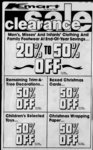
| OCR Text |
Show DAVIS COUNTY CLIPPER, WEEKLY REFLEX DAVIS NEWS JOURNAL, DECEMBER 30, 1981 150 feet; th South 0 degrees TP2N RG2W, SLM, East Ltd., 12:079:0020, Unit C, 07' 41" West 85.57 feet; 87.86 Ft, South 37 feet, W Bldg 214, Lakeview Cond., thence South 88 degrees 25 59.9 feet, North 37 degrees SLM. Sec. 13: T4N-R120" West 150.07 feet to the 05 W 46.38 feet to Beg. Total Tax $312.72 POB. Cont. .30 Acres, Cont. .062 Acres. Casa Linda and Parkview Inv. Total Tax Total Tax $485.22 $272.54 Ltd., 12:079:0021, Unit E, E. H. J. Corporation, 12:065:-006- 4, Bert E. and Norma Jean. WeaBldg 214, Lakeview Cond,, Beg N 33.47 feet and ver. 12:072:0011, Lor 11, SLM. Sec. 13: T4N-RI. West 816.91 feet from Comer Pratt's Sub., Situated In Sec Total Tax $312.72 Comm to Sec 11, 12, 13 and 12, 4N, 2W, SLM, Cont. .154 Casa Linda and Parkview Inv. T4N-R214, Acres. Beg at NE Cor of Lot SLM; North Ltd., 12:079:0022, Unit F. 89 degrees 58 West 303.10 II, Pratt's Sub. Sec 12, Bldg 214, Lakeview Cond., 31 feet; North degrees 58' TP2N, RG2W, SLM. North SLM. Sec. 13: T4N-R130" West 440.85 ft; N 58 de130.89 feet, South 130.89 Total Tax $312.72 01 30 East 388.66 grees feet, East 58.64 feet to beg. Casa Linda and Parkview Inv. 42 South Sd tract being part of Lot 16, feet; degrees 36 Ltd., 12:079:0023, Unit A, East 476.00 feet; North 89 Cont. ,18 Acres. Total .334 Bldg 214, Lakeview Cond., 58 115.13 West degrees Acres. feet; Sec. 13: T4N-R1SLM. thence S 00 degrees 02' West Total Tax $269.39 Total Tax $312.72 229.75 feet to POB. Cont. 12:072:-001Hideo and Hori Miya, Casa Linda and Parkview Inv. 4.24 Acres. All of Lots 13 and 15, Ltd., 12:079:0024, Unit B, Total Tax $1,656.53 Pratts Sub: Sec 12; T4N-R2Bldg 216, Lakeview Cond., Ricky L. Thurgood, 12:065:0070, SLM: Cont. .129 and SLM. Sec. 13: T4N-R1.203 Acres. Also beg 539.25 Beg N 0 degrees 07 41" East Total Tax $312.72 1367.7 feet along Sec In fr feet North 393 ft W of SE Casa Linda and Parkview Inv. SW Comer of Sec 11; T4N-R2Cor of NE 14 of Sec 12; Ltd., 12:079:0025, Unit C, T4N-R2SLM: Run thence N 0 SLM: Thence Bldg 216, Lakeview Cond., West 19.02 feet; thence South degrees 07 41" East 105 SLM. Sec. 13: T4N-R1130.58 feet to North line of feet; thence East 474.28 feet; Total Tax $312.72 thence South 27 degrees 09' Lot 13, sd sub, thence East Inv. Parkview and Casa Linda East 44.2 feet; thence South 19.02 thence North feet; Unit D, 12:079:0026, Ltd., 89 degrees 38 30 130.58 feet to POB. Cont. .05 West Bldg 216, Lakeview Cond., 158.55 feet; thence South 0 Acres Total .382 Acres. SLM. Sec. 13: T4N-R1Total Tax degrees 07 41" West 55.43 $784.55 $312.72 Total Tax David B. and Angela P. Hoi feet; thence South 88 degrees Casa Linda and Parkview Inv. 25 20" West 153.08 feet; brook, 12:073:0004, Comm at Ltd., 12:079:0027, Unit A, thence North 0 degrees 07' a pt 798 ft W along Sec In fr Bldg 218, Lakeview Cond., 41 East 85.57 feet; thence the NE Cor of NW 14 of Sec SLM. Sec. 13: T4N-R1West 150 feet; thence South 0 SLM: Thence 13, T4N-R2Total Tax $312.72 W 86 feet; thence South 166 degrees 07 41" West 90.02 Casa Linda and Parkview Inv. feet; thence South 88 degrees feet; thence East 86 feet; Ltd., 12:079:0028, Unit B, ' 20 25 West 33 feet to thence North 166 feet to the Bldg 218, Lakeview Cond., thence POB. .60 Acres. POB. Cont. .327 Acres. SLM. Sec. 13: T4N-R1Total Tax Total Tax $248.91 $191.27 Total Tax $312.72 C. and Leola Hamblin, Robert N. and Evelyn E. WagRoyal Casa Linda and Parkview Inv. 12:067:0001, ner, 12:073:0016, Beg at a pt Beg at NW cor Ltd., 12:079:0029, Unit C, of NE 14 of Sec 12 T2N North 0 degrees 10 11" East Bldg 218, Lakeview Cond., S Run 515.5 150 line feet along sec R2W, SLM, ft. and SLM. Sec. 13: T4N-R1East 100 feet, North 150 feet, East 33 feet and South 89 deTotal Tax $312.72 West 100 feet to Beg. Cont. 49 871.2 feet 49 East grees Casa Linda and Parkview Inv. .3443 of an acres. from SW Cor of NW 14 of Ltd., 12:079:0030, Unit D, Total Tax $78.77 Sec. 13, T4N, R2W; SLM: Bldg 218, Lakeview Cond., Edwin M. and Afton C. Higley, Run thence N 0 degrees 10 SLM. Sec. 13: T4N-R112:067:0005 11" East 199 feet; thence Beg 367.08 feet Total Tax $312.72 South of NW Cor NE 14 South 89 degrees 49 49 Casa Linda and Parkview Inv. Sec. 12 TP4N, RG2W, SLM, East 415.8 ft, m or I, to E In Ltd., 12:079:0031, Unit A, East 404.58 feet, South 120 of W 12 of NW 14 thence Bldg 222, Lakeview Cond., South 0 degrees 10' 10" West feet, West 404.58 feet, North SLM. Sec. 13: T4N-R1120 feet to Beg. Cont. 1.11 100 ft thence N 89 degrees Total Tax $312.72 49 Acres. 49" West 415.8 feet, and Parkview Inv. Linda Casa Total Tax $205.59 MOL, to POB. Cont. 1.00 Unit 12:079:0032, B, Ltd., Keven L. and Emma L. Hardy, Acres. Bldg 222, Lakeview Cond., Total Tax $36.23 12:067:0010, Beg 847.08 feet SLM. Sec. 13: T4N-R1South from N 14 Sec cor of Jesse Gene and Ila R. Brinker-hof- f, Total Tax $312.72 Sec 12, T2N, R2W, SLM, 12:077:0018, Beg N Casa Linda and Parkview Inv. 315.5 feet from SW Cor of South 60 feet, E 404.58 feet, Unit C, Ltd., 12:079:0033, SW 14 of NW 14 Sec 13; North 60 ft. W 404.58 ft to Bldg 222, Lakeview Cond., T4N-R2.55 Cont. Acres. SLM: Thence Beg. SLM. Sec. 13: T4N-R1Total Tax North 100 feet; thence East $315.08 Total Tax $312.72 1320 feet; thence South 100 Mark J. Eatchel, 12:067:0012, Casa Linda and Parkview Inv. 1027.08 at feet West 1320 South thence feet of to feet; Beg Unit C. Ltd., 12:079:0034, NW Cor of NE 14 of Sec 12, POB, Cont. 3.03 Acres. Bldg 222, Lakeview Cond., Total Tax $550.60 T2N, R2W, SLM, E 404.58 SLM. Sec. 13: T4N-R1feet, North 60 ft. West 404.58 Stanley L. and Irene T. Weeks, Total Tax $312.72 12:076:0001, Beg 2 rds W and Ft; South 60 ft to Beg. Cont. Casa Linda and Parkview Inv. 71 rds South fr cen of Sec 13; .56 Acres. Ltd., 12:079:0035, Unit C, T4N-R2SLM: Run thence Total Tax $356.04 Bldg 224, Lakeview Cond., W 207 Ft to W line of Layton Ruby Hamblin Barber, 12:067:-001- 9, Sec. 13: T4N-R1SLM. City; Thence South 0 degrees Beg 437.58 feet Eat, Total Tax $312.72 11 05" West 132 feet along 1156.92 feet North of SW cor Casa Linda and Parkview Inv. sd W line; thence East 207 of NE 14 of Sec 12, 4N, 2W, Unit B. 12:079:0036, Ltd., feet to West line of a st; SLM, North 79 feet, West Bldg 224, Lakeview Cond., thence N 132 feet along W 123 ft, South 79 feet. East SLM. Sec. 13: T4N-R1line of said street to POB. 123 feet to Beg. Cont. .22 Total Tax $312.72 Cont. .63 Acres. Acres. Casa Linda and Parkview Inv. $640.07 Total Tax Total Tax $191.41 Ltd., 12:079:0037, Unit C, Ellen B. Smith, 12:067:0021, Stanley L. and Irene T. Weeks, Bldg 224, Lakeview Cond., at on 6.63 1974 a pt feet chs E and 12:076:0005, Beg SLM. Beg Sec. 13: T4N-R171 In W rds of SW Cor N fr of NE 14 of Layton City Total Tax $312.72 South and 240 feet West from See 12, T4N-R2SLM: Casa Linda and Parkview Inv. Cen of Sec 13; T4N-R2Thence East 258.11 ft MOL Ltd., 12:079:0038, Unit D, SLM: Run thence West 424 to Westerly In of st road; Bldg 224, Lakeview Cond., thence South 37 degrees 00 feet; thence South 8 rds; SLM. Sec. 13: T4N-R1thence East 424 feet to said E 58.46 ft MOL alg sd Wly Total Tax $312.72 W In; thence North 8 rods to In to NE Cqr of Lot 1, Smith Parkview Linda and Inv; Casa POB. Cont. 1.28 Acres. Est Sub; thence S 87 degrees Unit 12:079:0039, A, Ltd., $228.09 Total Tax 52 W 285.45 ft; MOL; to a Lakeview 226, Cond., Bldg Casa Linda and Parkview Inv. SLM. Sec. 13: T4N-R1pt S of Beg; thence N 67.23 Ltd., 12:078:0001, Unit A, ft, MOL, to POB. Cont. .549 Total Tax $312.72 Acres. Bldg 174, Lakeview Cond., Casa Linda and Parkview Inv. T4N-R113: SLM. Sec. Total Tax $93.74 Unit B, Ltd., 12:079:0040, $312.72 Total Tax Ruby and Ruth Hamblin Barber, Bldg 226, Lakeview Cond., Parkview Inv. Casa Linda and 12:067:0023, SLM. Sec. 13: T4N-R1Beg at a pt 1 182.97 ft N ft SW cor of NE Ltd., 12:078:0002, Unit B, Total Tax $312.72 T4N-R2Lakeview 12 SLM: Cond., 14 Sec Bldg 174, Casa Linda and Parkview Inv. T4N-R113: SLM. Sec. Thence North 33 feet; thence Ltd., 12:079:0041, Unit C, $312.72 Total Tax East 4.766 chains; thence S Bldg 226, Lakeview Cond., Parkview Inv. and Linda 5 Casa West thence 47.43 feet; SLM. Sec. 13: T4N-R1Unit M C, 14.43 12:078:0003, N or thence Ltd., ft, rods; Total Tax $312.72 Lakeview W 174, Cond., of th E A Pt Bldg to L, Beg. Casa Linda and Parkview Inv. SLM. Sec. 13: T4N-R1232.08 ft to POB Cont. .34 Unit D, Ltd., 12:079:0042, $312.72 Total Tax Acres. Bldg 226, Lakeview Cond., Casa Linda and Parkview Inv. Total Tax $78.77 SLM. Sec. 13: T4N-R1Ltd., 12:078:0004, Unit D, Total Tax $312.72 Douglas R. and Carolyn M. Bldg 174, Lakeview Cond., Drake, 12:067:0030, Beg at a Casa Linda and Parkview Inv. SLM. Sec. 13: T4N-R1pt E 557.58 feet. North 529.7 Ltd., 12:079:0043, Unit E, $312.72 Total Tax feet fr the SW cor of NE 14 Bldg 226, Lakeview Cond., Casa Linda and Parkview Inv. SLM. of Sec 12, 4N. 2W, SLM, Sec. 13: T4N-R1Ltd., 12:078:0005, Unit A, North 404 feet M or L to S Total Tax $312.72 Bldg 180, Lakeview Cond., line of Camp Bell Hts Sub., Casa Linda and Parkview Inv. T4N-R1SLM. 13: Sec. E 60 ft, S 404 ft M or L. W Ltd., 12:079:0044, Unit F, $312.72 Total Tax 60 ft to Beg. Cont. .56 Acres. Bldg 226, Lakeview Cond., Inv. Parkview and Casa Linda $40. SLM. Total Tax Sec. 13: T4N-R1Unit B, 12:067:0032 Ltd., 12:078:OQO6, Total Tax Katie $312.72 Harris, Lakeview Cond., Bldg 180, Casa Linda and Parkview Inv. Beg at a pt 448.08 feet South T4N-R1SLM. 13: Sec. Sec and 2 rods W fr NE cor Ltd., 12:079:0045, Unit A, $312.72 Total Tax SLM: Thence 12; T4N-R2Bldg 228, Lakeview Cond., Inv. Parkview and Linda W Casa thence SLM. Sec. 13: T4N-R1South 295.76 feet; Unit C, 12:078:0007, N 295.74 Ltd., thence $312.72 177.44 feet; Total Tax Lakeview Cond., 180, 177.44 feet Inv. Parkview East Bldg Linda and Casa feet; thence T4N-R1SLM. 13: Sec. 1.25 Acres. Unit Cont. 12:079:0046, to POB. B, Ltd., $312.72 Total Tax $246.55 Total Tax Bldg 228, Lakeview Cond., Parkview Inv. and T4N-R1Linda Casa 13: SLM. Sec. 12:067:0049, G. Aragon, Ruby Ltd., 12:078:0008, Unit D, Total Tax $312.72 Beg 679.15 ft N. 574.52 feet Bldg 180, Lakeview Cond., Casa Linda and Parkview Inv. W fr SE Cor of NE 14 of T4N-R1SLM. Sec. 13: Sec 12, 4N, 2W, SLM, South Ltd., 12:079:0047, Unit C, $312.72 Total Tax 149.6 feet. West 34.5 feet. Bldg 228, Lakeview Cond., Casa Linda and Parkview Inv. SLM. Sec. 13: T4N-R1North 139.6 feet, E 34.5 feet Ltd., 12:079:0008, Unit A, Total Tax $312.72 to Beg. Cont. .11 Acres. Bldg 206, Lakeview Cond., $233.95 Casa Linda and Parkview Inv. Total Tax T4N-R1SLM. Sec. 13: Weber Davis Development, Ltd., 12:079:0048, Unit D, $312.72 Total Tax Bldg 228, Lakeview Cond., Beg at a pt 612.35 Inv. Parkview Casa Linda and SLM. Sec. 13: T4N-R1feet N and 33 ft W and N 89 Unit B, Ltd., 12:079:0010, Total Tax $312.72 degrees 35 West 1 10 feet and Lakeview Cond., Bldg 206, Casa Linda and Parkview Inv. 69.30 feet South from E 14 T4N-R1SLM. 13: Sec. SLM: Cor Sec 12; T4N-R2Ltd., 12:079:0049, Unit A, $312.72 Total Tax Thence South 3.5 feet thence Bldg 230, Lakeview Cond., Inv. Parkview and Linda Casa SLM. Sec. 13: T4N-R1W 190 feet; North 3.5 ft; East Unit C, 12:079:0011, Total Tax $312.72 Ltd., 190 feet to POB. Cont. .015 Lakeview Cond., 206, and Parkview Inv. Bldg Casa Linda Acres. SLM. 13: T4N-R1$3-9Sec. Unit B, Total Tax Ltd., 12:079:0050, $312.72 Total Tax Bldg 230, Lakeview Cond., Joseph H. and Maijean B. AnInv. Parkview and T4N-R1Linda Casa 13: SLM. All of Sec. derson, 12:070:0016, Ltd., 12:079:0011, Unit D, $312.72 Total Tax Lots 16 and 18 Campbell Bldg 206, Lakeview Cond., Casa Linda and Parkview Inv. Heights Sub. Less th foil: SLM. Sec. 13: T4N-R1Unit C, Ltd., 12:079:0051, Beg at thence SW cor of Lot $312.72 Total Tax Bldg 230, Lakeview Cond., 16, Campbell Heights, and SLM. Casa Linda and Parkview Inv. Sec. 13: T4N-R1run th N 0 degrees 18 East Total Tax $312.72 Ltd., 12:079:0013, Unit A, along ppty In divinding Lot Bldg 212, Lakeview Cond., Casa Linda and Parkview Inv. 14 and 16, 68 feet thence T4N-R1SLM. Sec. 13: Unit D, Ltd., 12:079:0052, North 89 degrees 50 East 90 $312.72 Total Tax Bldg 230, Lakeview Cond., feet; thence North 0 degrees SLM. Casa Linda and Parkview Inv. Sec. 13: T4N-R118 East 2 feet; thence 89 deLtd., 12:079:0014, Unit B, Total Tax $312.72 grees 50' East 30 feet to East Bldg 212, Lakeview Cond., Casa Linda and Parkview Inv. ppty In of Lot 18, thence T4N-R1SLM. Sec. 13: Ltd., 12:079:0053, Unit A, South 0 degrees 18 West 70 $312.72 Total Tax Bldg 232, Lakeview Cond., feet to SE Cor of Lot 18; SLM. Casa Linda and Parkview Inv. Sec. 13: T4N-R1thence South 89 degrees 50 Ltd., 12:079:0015, Unit C, $312.72 Total Tax West 120 feet to thence POB. Bldg 212, Lakeview Cond., Casa Linda and Parkview Inv. Cont. .186 Acres. T4N-R1SLM. 13: Sec. $356.04 Ltd., 12:079:0054, Unit B, Total Tax $312.72 Total Tax Bldg 232, Lakeview Cond., Donald C. Miller, 12:070:0021, Parkview Inv. and SLM. Casa Linda Sec. 13: T4N-R1All of Lot 21, Blk 1, CampUnit D, Ltd., 12:079:0016, $312.72 Total Tax bell Heights Sub. Sec 12; Lakeview Cond., Bldg 212, Casa Linda and Parkview Inv. T4N-R2SLM: Cont. .187 T4N-R1SLM. 13: Sec. Ltd., 12:079:0056, Unit C, Avlvdl $312.72 Total Tax $308.78 Bldg 232, Lakeview Cond., Total Tax Parkview Inv. and SLM. Casa Linda Sec. 13: T4N-R1Noel G. and Margaret Larsen, Unit A, Ltd., 12:079:0017, $312.72 Total Tax 12:071:0011, Lot 11, Camp-be- ll Lakeview Cond., Bldg 214, Casa Linda and Parkview Inv. Heights Ex. A Sec 12, T4N-R1SLM. 13: Sec. Ltd., 12:079:0057, Unit D, 4N, 2W, SLM, Colnt .148 $312.72 Total Tax Bldg 232, Lakeview Cond., Inv. Parkview and SLM. Casa Linda Sec. 13: T4N-R1$263.88 Total Tax Unit B, Total Tax $312.72 Ltd., 12:079:0018, Albert J. and Lucille Trujillo, Lakeview Cond., Bldg 214, Casa Linda and Parkview Inv. 12:071:0031, Lot 31, CampT4N-R1SLM. 13: Sec. Ltd., 12:079:0058, Unit E, bell Heights Ex. A Sec 12, $312.72 Total Tax Bldg 232, Lakeview Cond., 4N, 2W, SLM, Cont .148 Inv. Parkview and Linda Casa SLM. Sec. 13: T4N-R1Unit C, $282-7Ltd., 12:079:0019, $312.72 Total Tax TotsdTax... Lakeview Cond., Bldg 214, Casa Linda and Parkview Inv. Leanora K. Wilson, 12:071:0035, T4N-R1SLM. 13: Sec. NW Ltd., 12:079:0059, Unit A, Beg on E In Hy 91 at $312.72 Total Tax Caapbeu Bldg 234, Lakeview Cond., Lot 18, Cor Inv. Parkview and Linda Casa SLM. Sec. 13: T4N-R1Heights, Ex. A, Sec. 12, , i i f PAGE NINETEEN . 666 North feet; Thence cept E 1. 1 ft there of, Cont, M and J. Constr. Co. Inc., Total Tax $312.72 .53 Acres. thence East 353 feet; thence All of Lot 103, Casa Linda and Parkview Inv. North 1314 feet; thence West luioi tax........ Melanie Acres Phase I; Sec Unit B, Ltd., 12:079:0060, Eric J. and Janice V. Nelson, 437 feet; thence South 1980 SLM: Cont. 14, T4N-R2Bldg 234, Lakeview Cond., 84 All of Lot 69, feet to 12:098:0069. East thence feet; .18 Acres. SLM. Sec. 13: T4N-R1Ranchettes West Sub No. 2; POB, Cont. 14.46 Acres. Total Tax $207.95 Total Tax $312.72 $135.38 SLM: Sec 17; T4N-R2TotalTax Paul Peter and Louise J. Meline, Casa Linda and Parkview Inv. 12:087:0060, Cont. .50 Acres. M. D. Glauser, 12:083:0108, All of Lot 108, Unit C, Ltd., 12:079:0061, $343.81 Total Tax Beg. at a pt 443 feet North fr Melanie Acres Phase 1; Sec Bldg 234, Lakeview Cond., Mark D. and Cory L. Anderson, SW comer of Sec 15 T4N-R2SLM: Cont. 14, T4N-R2SLM. Sec. 13: T4N-R1-- All of Lot 73, 12:099:0073. SLM: Thence North J .18 Acres. Total Tax $312.72 Ranchettes West Sub No. 2; feet thence East 10 rods Total Tax $327.68 Casa Linda and Parkview Inv. SLM: Sec 17; T4N-R2thence South 5 ft thence W Paul Peter and Louise J. Meline, Unit D, Ltd., 12:079:0062, Cont. .50 Acres. 10 rods to POB Cont. .019 12:083:0112, All of Lot 108, Bldg 234, Lakeview Cond., $327.73 Total Tax Acres. Melanie Acres Phase 1; Sec Sec. 13: SLM. ; $3.35 Brent K. and Elaine C. Dumas, TotalTax SLM: Cont. 14, T4N-R2Total Tax $312.72 12:089:-003All of Lot 84, 12:099:0084. Elwood C. Chadboume, .18 Acres. Casa Linda and Parkview Inv. Ranchettes West Sub No. 2; Lot 3J, Smedley Acres Total Tax $435.60 Unit E, Ltd., 12:079:0063, T4N-R2SLM: Sec 17; No. 2, Sec 15, T4N, R2W, Paul Peter and Louise J. Meline, Bldg 234, Lakeview Cond., Cont. .51 Acres. .SLM, Cont. .195 Acre. 12:083:0116, All of Lot 116, SLM. Sec. 13: T4N-R1$349.84 $408.15 Total Tax TotalTax Melanie Acres Phase I; Sec Total Tax $312.72 Bruce W. and Leanne Christen Vem E. and Margaret Dicker SLM: Cont. 14, T4N-R2Casa Linda and Parkview Inv. 89 sen. 12:099:0093. All of Lot son, 12:091:0001, Beg N .18 Acres. Unit F, Ltd., 12:079:0064, 93, Ranchettes West Sub No. Total Tax degrees 49 43" West 818.84 $216.62 Bldg 234, Lakeview Cond., of SLM: feet aaong sec In fr NE cor 2; Sec 17; T4N-R2Classic Construction Co. Inc., SLM. Sec. 13: T4N-R1Cont. .50 Acres. NW 14 of Sec 16, T4N-R212:083:0127, All of Lot 127, Total Tax $312.72 50 $343.14 TotalTax SLM: South 4 degrees Melanie Acres Phase 2; Sec Casa Linda and Parkview Inv. West 435.6 feet; North 89 deStephen C. and Audrey Criddle, SLM: Cont. 14, T4N-R2Unit A. Ltd., 12:079:0065, 1 of All Lot 97. 12:099:0097. West ft; .24 Acres. grees 49' 43 Bldg 238, Lakeview Cond., Ranchettes West Sub No. 2; North 4 degrees 50 East Total Tax $76.41 Sec. 13: T4N-R1SLM. SLM: Sec 17; T4N-R2435.6 feet; South 89 degrees M and J. Constr. Co. Inc., Total Tax $312.72 Cont. .51 Acres. 49 43" East I foot to POB. All of Lot 130, Casa Linda and Parkview Inv. $76.40 Total Tax Cont. .01 Acrs. Melanie Acres Phase 2; Sec Unit B, Ltd., 12:079:0066, ...$3.35 Total Tax SLM: Cont. 14, T4N-R2Taney G. Brown. 12:099:0104. Bldg 238, Lakeview Cond., Duane Edward and Venita L. All of Lot 104. Ranchettes .21 Acres. Sec. 13: T4N-R1SLM. Frahm, 12:092:0009. Beg on West Sub No. 2; Sec 17; Total Tax $416.69 Total Tax $312.72 W line of a 66 ft st which is T4N-R2SLM: Cont. .50 Dale T. Smedley, 12:083:0131, Casa Linda and Parkview Inv. West 0 degrees 06' 28" West Acres. All of Lot 131, Melanie Acres Unit C, Ltd., 12:079:0067, 517.40 feet along sec line and $241.80 TotalTax Phase 2; Sec 14, T4N-R2Bldg 238, Lakeview Cond., center line of said st and Armond D. and Susan W. CarSLM: Cont. .20 Acres. SLM. Sec. 13: T4N-R1North 89 degrees 53' 32" Total Tax ter, 12:099:0106. All of Lot $218.19 Total Tax $312.72 West 33 feet from NE comer West Sub 106, Ranchettes John D. and Tina Harms, Casa Linda and Parkview Inv. SLM: of Sec 16; T4N-R2No. 2; Sec 17: T4N-R2All of Lot 142, Unit D, Ltd., 12:079:0068, Thence North 89 degrees 53 SLM: Cont. .50 Acres. Melanie Acres Phase 2; Sec Bldg 238, Lakeview Cond., 32" West 130 feet along a 1 $191.13 Total Tax SLM: Cont. 14, T4N-R2SLM. Sec. 13: T4N-R1wall; foot high concrete .20 Acres. Total Tax $312.72 Security Title Co. of Davis Co. thence North 0 degrees 06 12:099:0110, The West I ft of $412.75 Total Tax Casa Linda and Parkview Inv. 28" East 100 feet; thence Lot 76 Ranchettes West No. Dale T. and Helen B. Smedley, Unit A, Ltd., 12:079:0069, 32" South 89 degrees 53' SLM. 2 Sec. 17 T4N-R212:083:0151, All of Lot 151, Bldg 1760, Lakeview Cond., East to said West line of said Cont. .002 Acres. Melanie Acres Phase 2; Sec SLM. Sec. 13: T4N-R106 S 0 degrees street; thence $3.35 Total Tax SLM: Cont. 14, T4N-R2Total Tax $312.72 28" West 100 feet to POB. Azalia J. Weir. 12:009:0114. All .35 Acres. Casa Linda and Parkview Inv. Acres. .30 Cont of Lot 76 Ranchettes West Total Tax $422.99 Ltd., 12:079:0070, Unit B, $510.02 TotalTax No. 2 Sec. 17 T4N-R2Dale T. and Helen B. Smedley, Bldg 1760, Lakeview Cond., D. and Connie V. Marsell, Brent SLM. Cont. .50 Acres Ex12:083:0152, All of Lot 152, SLM. Sec. 13: T4N-R112:092:0049, Beg at a pt 60 Melanie Acres Phase 2; Sec $312.72 Total Tax cept the W 1 ft of said lot feet South 89 degrees 43 30" cont .002 Acres Balance Cont SLM: Cont. 14, T4N-R2Casa Linda and Parkview Inv. West of NW comer of Lot 10 .498 Acres. .35 Acres. Unit C, Ltd., 12:078:0071, 1 said No. Sunset Est West $341.13 Total Tax $358.40 Total Tax Bldg 1760, Lakeview Cond., 0 feet North is also 283.19 T4N-R1B. pt Dale T. and Helen SLM. Sec. 13: Kathryn B. Byrd. 12:100:0003, Smedley, degrees 06' 28" East and 12:083:0156, All of Lot 156, Total Tax $312.72 Beg 156 feet North fr SE Cor 1168 feet South 89 degrees SLM: Sec. 18. T4N-R2Melanie Acres Phase 2; Sec Casa Linda and Parkview Inv. 43 30" West from E 14 North 176 feet; West 65 feet; SLM: Cont. Unit D. 14, T4N-R2Ltd., 12:078:0072, comer of Sec 16, T4N-R2.35 Acres. thence SW'ly 195 feet; MOL, Bldg 1760, Lakeview Cond., SLM: Thence South 0 deto pt West of Beg; thence Total Tax $426.93 SLM. Sec. 13: T4N-R1East 187 feet MOL, to Beg. M and J. Constr. Co. Inc., grees 16 30" West 110 feet s Total Tax $312.72 to N line of 2175 South Street All of Lot Cont. .60 Acres. 11, Casa Linda and Parkview Inv. South 89 degrees thence $149.98 TotalTax Melanie Acres Phase I; Sec Ltd., 12:078:0073, Unit A, 4330" West 91 feet along John R. and Michele B. GodSLM: Cont. 14, T4N-R2Bldg 1770, Lakeview Cond., 0 said N line thence North .19 Acres. SLM. Sec. 13: T4N-R1frey, 12:100:0006, Beg on W in of a er st at a pt 954 ft N degrees 16 30" West 110 feet $472.62 Total Tax Total Tax $312.72 43 89 North thence degrees and 32.2 feet W of SE Cor of Casa Linda and Parkview Inv. Larry D. Goodrich, 12:084:0015, POB 91 feet East to 30" SLM: All of Lot 15, Melanie Acres Sec 18. T4N-R2Unit B, Ltd., 12:078:0074, Cont. .23 acres out of Thence W 231.7 feet thence Phase 1; Sec 14, T4N-R2Bldg 1770, Lakeview Cond., was or North 94 feet thence East SLM: Cont. .22 Acres. SLM. Sec. 13: T4N-R10045 Now 0050. 231.7 feet to West line of said $385.97 Total Tax Total Tax $312.72 $488.58 Tax Total M and J. Constr. Co. Inc., street thence S 94 feet to Casa Linda and Parkview Inv. J. Kelly and Sandy Jean Hansen, All of Lot 47, POB Cont. .50 Acres Out of Unit C, Ltd., 12:078:0075, 12:094:0025, A part of SE 14 Melanie Acres Phase 1; Sec Bldg 1770, Lakeview Cond., SLM: of Sec 16; T4N-R2SLM: Cont. $180.60 TotalTax SLM. 14, T4N-R2Sec. 13: T4N-R1Beg at a pt on E'ly line of .27 Acres. John R. and Michele B. GodTotal Tax $312.72 Bluff Road, said point being ......$204.80 Total Tax Casa Linda and Parkview Inv. frey, 12:100:0023. Beg on W North 0 degrees 06 28" East In cert st, N 1048 ft. and Unit D, Dale T. and Helen B. Smedley, Ltd., 12:078:0076, 1335.80 feet along sec line, West 32.2 feet from SE cor All of Lot 182, 084:0182. Bldg 1770, Lakeview Cond., North 89 degrees 53 32" Sec 18, Tp4N, Rg2W, SLM, SLM. Sec. 13: T4N-R1Melanie Acres Phase 2; Sec feet and North West 1555. West 231.7 feet. North 94 Total Tax $312.72 SLM: Cont. 14, T4N-R2144.46 East 0 degrees 06 28" feet, East 231.7 feet. North Casa Linda and Parkview Inv. .18 Acres. said of SE feet from comer 94 feet, East 231.7 feet to Total Tax Ltd., 12:078:0077, Unit A, $126.82 Sec 16; running thence along West line said st, thence 94 ft M and J. Constr. Co. Inc., Bldg 1780, Lakeview Cond., Road South Bluff line of S to Beg. Cont. .50 Acre. Ely SLM. Sec. 13: T4N-R1All of Lot 189, 110 05 50 East 43 degrees Total Tax $14.37 Total Tax $312.72 Melanie Acres Phase 2; Sec 46 North thence degrees feet; Casa Linda and Parkview Inv. Kiplin and Susan Rasmussen, SLM: Cont. 14, T4N-R2174.20 East 09 55" feet; 12:102:0009, Beg at a pt on th .25 Acres. Ltd., 12:078:0078, Unit B, thence North 43 degrees 50' W In of a 66 ft wide stwh is S Total Tax Bldg 1780, Lakeview Cond., $77.19 thence 110 05 West feet; T4N-R11077.5 ft alg th sec In and W SLM. Sec. 13: M and J. Constr. Co. Inc., South 46 degrees 09' 55" 33 ft fr thence NE cor of Sec Total Tax $312.72 All of Lot 190, West 174.20 feet to POB. SLM: Thence Casa Linda and Parkview Inv. 20, T4N-R2Melanie Acres Phase 2; Sec Cont. .44 Acres. W 217.8 feet; thence South SLM: Cont. Ltd., 12:078:0079, Unit C, 14, T4N-R2$816.30 Total Tax 100 ft; thence E 217.8 feet; .21 Acres. Bldg 1780, Lakeview Cond., Mont Kay and Althora B. thence N 100 feet to thence SLM. Sec. 13: T4N-R1Total Tax $74.04 12:095:0001, Lot 1, POB. Cont. .50 Acres. Total Tax $312.72 M and J. Constr. Co. Inc., West Sunset View Estates Total Tax $69.36 Casa Linda and Parkview Inv. All of Lot 203, T4N-R21. Sec No. 16, Dale D. Clark, Unit D, 12:103:0012, Ltd., 12:078:0080, Melanie Acres Phase 2; Sec Acres. Cont. .23 SLM: Beg at NW cor of Sec 21; SLM: Cont. 14, T4N-R2Bldg 1780, Lakeview Cond., $53.62 Total Tax T4N-R2SLM. Thence S SLM. Sec. 13: T4N-R1.19 Acres. V. and R. Josie Hector Fuentes, 192 feet; th E 440 ft; thence S Total Tax $312.72 Total Tax $308.78 Lot All of 12:097:0006, 6, 100 ft; thence E 120 ft; Casa Linda and Parkview Inv. M and J. Constr. Co. Inc., Ranchettes West Sub; Sec thence South 70 degrees 40' Unit A, All of Lot 204, Ltd., 12:078:0081, T4N-R2SLM: 17; Except East 339.12 feet; thence Melanie Acres Phase 2; Sec Bldg 1780, Lakeview Cond., E 1.1 ft there of, Cont. .50 South 615.73 feet, MOL, to S SLM. Sec. 13: T4N-R1SLM: Cont. 14, T4N-R2Acres. W line of 12 of NW 14 of Total Tax $312.72 .19 Acres. $308. TotalTax NW 14 of said Sec-2th E Casa Linda and Parkview Inv. Total Tax $208.74 Crayth-om- e, A. and L. Don Mary 220 N 1320 ft, MOL to th Unit B, ft; Ltd., 12:078:0082, James H. and Geraldine Rent All of Lot 12:097:0009, W N line of said thence Lakeview Cond., sec; Bldg 1790, 12:085:0001, meister, Beg 9, Ranchettes West Sub; Sec 660 ft to POB Cont. 8.55 SLM. Sec. 13: T4N-R1227.15 feet South from NW T4N-R2SLM: Except 17; Total Tax $312.72 Cor Sec. 15, TP4N, RG2W, E 1.1 ft there of, Cont. .50 Total Tax Casa Linda and Parkview Inv. $2.50 SLM, East 143.3 feet. North Acres. Dale D. and Ruth E. Clark, 76 feet, West 143.3 feet to Ltd., 12:078:0083, Unit C, $326.39 TotalTax 12:103:0013, Thence East 12 Sec. Line, South 76 feet to Bldg 1790, Lakeview Cond., Mark W. and Lorie P. Ohlin, of NW 14 of NE 14 Sec 21, Sec. 13: T4N-R1SLM. Beg. Less St. Cont. .19 of Lot All 13, 12:097:0013, Total Tax $312.72 T4N, R2W, SLM: Cont. Less Acres. Ranchettes West Sub; Sec street 19.50 Acres. Casa Linda and Parkview Inv. Total Tax $318.35 T4N-R2SLM: 17; Except Unit D, TotalTax $3.12 Ltd., 12:078:0084, Larry M. and Connie R. Buttare, .50 1.1 Cont. ft E there of, Dale D. Clark, 12:103:0015, Bldg 1790, Lakeview Cond., 12:085:0021, Beg 40 rods East Acres. SLM. Sec. 13: T4N-R1Thence West 38 rods of th along sec In and 235 feet $371.29 TotalTax NW 14 of thence NE 14 and Total Tax $312.72 South rom NW Comer of Sec and W. Kevin Robert Cheryl Sherman G. and Susan B. Ben thence E 65.0 rods of th NE SLM: and run 15, T4N-R2All of 12:097:0014, Payne, 14 of the NW 14 of Sec 21, nett, 12:079:0019, thence 1.5 chains; thence Beg 375 West Ranchettes Lot 14, T4N-R1feet North and 153 feet East SLM: Cont. 51.50 South 865 feet thence West T4N-R2Sec 17; Sub; from SW Cor of NW 14 Sec Acres. Out of H 3029 or 1.5 chains: thence North 865 ft there 1.1 E SLM: T4N-R2Except SLM: Thence Now 14; feet to POB. Cont. 1.966 of, Cont. .50 Acres. E 61.5 Feet thence N 120 Total Tax $9.37 Acres. $344.48 Total Tax D. Dale and Ruth E. Clark, feet; thence East 524.7 feet; Total Tax $60.32 Steven W. and Diane N. Wall, thence South 137.5 feet; R. Thence West 40 and M. Connie Buttars, Larry All of Lot 15, 12:097:0015, thence North 89 degrees 59 rods of th SW 14 of thence 12:085:0022, Beg at a pt 12.5 Ranchettes West Sub; Sec 23 West 586.2 feet; thence NE 14 of Sec 21, T4N-R2chains East of NW comer of SLM: Except 17; T4N-R2North 0 degrees 09 08 East SLM: Cont. 20.00 Acres. Sec 15; T4N-R2SLM: .50 1.1 Cont. E ft there of, 17.5 feet to POB, Cont. 1.75 Also: Thence West 15 rods of Run thence East 194.2 feet; acres together with r of w. thence NE 14 of Thence NW thence South 19.67 rods; $327.06 TotalTax Total Tax 14 of Sec 21, T4N-R2$67.69 thence East 83 feet; thence B. and A. Steven Black, Gayle Eadson Company, 12:081:0029, SLM: Total 27.5 Acres. South 57 rods: thence West Lot All of 16, 12:097:0016, Total Tax $8.12 6.70 chains; thence North Beg at S 14 comer of Sec 14, Ranchettes West Sub; Sec Bertha P. Record, 12:103:0028, 4N, 2W, SLM, North 1320 2.50 chains; thence East 6 T4N-R2SLM: 17; Except feet, West 1089 feet. South 6 Beg at th NW cor of th S 12 rods; thence North E 1.1 ft there of, Cont. .50 1320 feet, East 1089 feet to of th NW 14 of Sec 21; T4N-R2chains; thence East 4 rods; Acres. SLM: Thence S 150 thence North 2.50 chains to beg. Less roads cont. 32.17 $325.72 TotalTax Acre. feet; thence East 440 feet; POB. Cont. 9.14 Acres. R. and W. David Thomp Terry Total Tax thence South 200 ft; thence $301.59 Total Tax $335.10 son, 12:097:0021, All of Lot W 440 feet; thence South 310 H. K. Stephenson Construction Monty Dick and La Tawn Wolf-leWest Ranchettes 21, Sub; feet to a pt 660 ft S of th 12:082:0004, Beg at a pt Co. Inc., 12:085:0036, Beg on T4N-R2ExSLM: Sec 17; North 0 degrees 15 01 East POB; thence E 160 rods; South line of a street 33 feet 1.1 Cont. ft E there of, cept thence North 660 ft; th West along Sec line 1438.65 feet South from NE cor NW 14 .55 Acres. from. Southeast comer of Sec T4N-R2160 rods to th POB. Cont. Sec. 15, SLM: $329.74 Tax Total J4N-R237.45 Acres. SLM: Run 14; Thence West 149 feet; South and J. Vicki L. Carlton Doyle, thence South 87 degrees 30 Total Tax 190 feet; W 115 ft; South 41 $5.62 12:097:0022, All of Lot 22, Ralph R. and West 225.785 feet; thence t, feet; W 66 feet; South 1716 Sherilyn F. West Sub; Sec Ranchettes South 249.55 feet paralleling Beg at a pt 363 feet E feet; East 330 feet; thence T4N-R2SLM: 17; Except East In of said Sec; thence E T4N-R2of NW cor of Sec 22, North 1947 feet to Beg, Cont. E 1.1 ft there of, Cont. .53 225.57 feet to East line of SLM: Thence S to Cen 14.15 Acres. said Sec; thence North 0 deLn of Old Bluff Rd; th NWly Total Tax $132.70 $319.02 TotalTax sd cen line to cen ln of H. K. Stephenson Construction grees 15 01 East 259.4 feet alg Jeff W. and Kristine Rawlings, Co. Inc., 12:085:0037, Beg on Co. Road; thence E to POB. along sec line to POB. Cont 12:097:0023, All of Lot 23, 1.32 Acres. Cont. .350 Acres. SE comer of NW 14 of Sec Ranchettes West Sub; Sec Total Tax $1,256.38 Total Tax 15, 4N, 2W, SLM, West 10.0 $1,680.86 T4N-R2SLM: Except 17; Edward D. and Louise Lore, Monty Dick and La Tawn Wolf-lechains. North 10.0 chains, E E 1.1 ft there of, Cont. .51 12:082:0013. Beg at a pt All of th N 12 10.0 10.0 South 12:105:0042, chains. Acres. 783.75 feet North of SW 14 of NW 14 of Sec chains to Beg. Cont. 10.00 along Total Tax $344.48 thence 14 sec In and East SLM: Except 22, T4N-R2Michael P. and Carol C. Leshko, 586.58 ft and North 371.25 ft. the folio: Beg 1650 ft S and TotalTax $93.83 12:097:0025, All of Lot 25, and E 1450 ft fr SW cor sec 248 feet E of thence NW Cor Price Robinson Machine Shop, Ranchettes West Sub; Sec 14, T4N-R2SLM; Thence of Sec 22, thence South 330 12:087:0024, Beg at a pt E T4N-R2SLM: Except 17; N 36 degrees 41 West 462.93 701.4 feet and South 95 feet ft; thence E 132 ft; thence E 1.1 ft there of, Cont. .48 feet, MOl, to thence South fr NW comer of SW 14 Sec North 330 feet; thence West Acres. line of Melanie Acres Sub 132 feet to th POB. Less str 15; T4N-R2SLM; Thence $344.48 Total Tax Phases I; Thence South 89 South 164.38 feet, MOl, to N to County Cont. 18.55 Acres and Jill W. Michael M. Bingham, East along 782-66784-13line of a st; thence W along Less to 773-17degrees 59 23 12:097:0026. All of Lot 26, thence South line of sd sub N line said st 135 feet; thence 1.65 Acres Remainder Ranchettes West Sub; Sec 880 feet; Thence South 87.6 16.90 Acres. North 164.38 feet, MOL, to a SLM: Except 17; T4N-R2feet, MOL, to thence NE Cor TotalTax $921.73 pt West of beg; thence East 1.1 ft E there .47 of, Cont. of ppty Conv In 708-47135 feet to POB, Cont. .511 Kenneth R. and Patsy L. ChamAcres. thence South 87 degrees 30 Acres together with rw. pion, 12:105:0043, Beg. 1420 Total Tax $328.40 W 225.785 feet; thence South ft South and 30 feet East of TotalTax $833.73 M. 249.55 Glover, 12:098:0065, Danny East feet; thence Reed W. and Viola L. Bennett, th NW cor of Sec 22, T4N-R2All of Lot 225.57 ft; thence South 24.25 65, Ranchettes SLM: Thence East 218 12:087:0036, Beg at cen of West Sub No. 2; Sec 17; feet, MOL, thence W 603.43 Sec 15, 4N, 2W, SLM, West feet; thence South 100 feet; T4N-R2E SLM: feet to POB Cont. 4.92 Except 10 chains, South 10 chains, E thence West 218 feet; thence 1.1 ft there of, Cont. .52 AprPC 10 chains, North 10 chains to North 100 feet to thence Total Tax $54.35 POB. Cont. .50 Acres. beg, Cont. 10.00 Acres. $329.74 TotalTax Leland R. Saunders, 12:083:-007Total Tax Total Tax $93.83 $5.00 All of Lot 74, Melanie Teddy G, and Sherry K. Morse, Harold S. and Thelma B. Sea-moGale Kenneth and Cynthia M. -12:098:0066. All of Lot 66, Acres Phase 1; Sec 14, T4N-R212:087:0050, Norman, 12:105:0044, Beg Beg 576 Ranchettes West Sub No. 2; SLM: Cont. .18 Acres. 1650 feet South and 248 feet feet W of SE comer SW 14 T4N-R2ExSec 17; SLM: Total Tax $72.47 Sec 15; T4N-PE of thence NW cor of Sec SLM: T4N-R2SLM: Thence South 330 feet; thence East 132 feet; thence N 330 feet; thence W 132 feet; thence North 330 feet; thence West 132 feet to the POB. Cont, 1.00 Acre. $10.62 Total Tax Robert A. and Marlane C. Beg S Nance, 12:106:0014. alg sec In 1602.48 feet and North 52 degrees 34' 10" West 1069.7 feet and North 17 46 degrees 30" West 1087.6 feet from E 14 cor sec SLM: Thence 22; T4N-R2North 46 degrees 17' 30" West 95.0 feet: thence North 43 degrees 42' 30" East 173.26 feet; thence North 89 degrees 38 30" East 132.22 feet: thence S 43 degrees 42' 30" West 265.21 ft to the POB. Cont. .48 Acres. $441.66 TotalTax Michael D. and Carol R. Thurgood. 12:106 0015. Beg S 89 degrees 53 47" West 1584.61 feet along 14 sec line fr NE Cor SE 14 Sec 22: T4N-R2SLM: Thence South 89 degrees 53' 47" West 249.12 feet along said 14 sec line to Cen In of rd; thence South 46 degrees 17' 30" East 179 feet along said center line: thence North 43 degrees 42' 30" East 173.26 feet to POB. Cont. .36 Acres. $1,855.11 Total Tax e. Jay Charles and Barbara S. 12:108.0023. Beg N 89 degrees 57'35" East 775 feet and South 0 degrees 14' 02 West 153 feet from NW cor SLM of Sec 23. T4N-R2and run thence South 0 degrees 14 02" West 47 feet: thence North 89 degrees 57' 35" Eat 100 feet; thence North 0 degrees 14' 02" East 200 feet thence South 89 degrees 57' 35" West 20 feet: thence South 0 degrees 14' 02" West 153 feet: thence South 89 degrees 57' 35" West 80 feet to POB Cont. .18 Acres. Total Tax $10.72 Jonnie Lee and Ladawna Watts. 12:108:0085. Beg 60 feet N 208 ft E SW Cor of N 12 of SW 14 of NW 14 of Sec-2T4N. R2W. SLM: and run thence North 125 feel: thence East 227 feet: thence South 125 ft para! to sd sec In: thence W 227 ft to POB Cont. .65 Ac. 22. TotalTax $40.21 Nick and Karyl Faulkner. feet 1325.6 Beg East and South 33 feet fr NW T4N-R2cor of Sec 24; SLM: Thence South 200 ft thence E 113.2 feet thence North 200 feet thence West 113.2 feet to POB Cont. .52 Acres. $802.80 TotalTax L. Paul and Sylvia B. Miller, Etal.. 12:111:0037, Beg at a pt N 89 degrees 51' 40" W 1322.74 feet along thence 14 sec In fr th E 14 cor of Sec SLM: Thence 26, T4N-R1S 0 degrees 12'32" West 329.95 Feet thence North 89 degrees 51 50" West 661.40 feet; thence North 0 degrees 12 50" East 329.98 feet to thence 14 sec line; thence South 89 degrees 51' 40" East 661.37 feet along thence 14 sec line to thence POB. Com. 5.00 Acres. Together with and subject to a R of W excepting therefrom an exist well. $51 60 Total Tax H. C. Massey, 12:112:0008, Beg at NW cor of NE 14 of Sec SLM: Run 27; T4N-R2thence South 89 degrees 59' 02" East 560.34 ft; thence South 0 degrees 12 48 West 500 feet; thence N 89 degrees 59' 02" West 560.34 feet to 14 Sec line; thence North 0 degrees 12 48" East 500 feet to POB, Cont. 4.88 Acres Together with and subject to a 60 ft R of W 30 ft on either side of the foil desc cen line; beg at a pt South 89 degrees 59' 02" East 560.34 feet fr NW cor of said NE 14 sec; and thence South 0 degrees 12' 48" West 880 feet. TotalTax $28.12 H. C. and Betty P. Massey, Beg at a pt South 0 degrees 12' 48" West 500 feet along 14 sec line fr NW Cor of NE 14 of Sec. 27; SLM: Thence T4NR2W; South 89 degrees 59 02 East 560.34 feet; thence South 0 degrees 12' 48" West 380 feet thence North 89 degrees 59 02" West 560.34 feet to 14 sec line; thence North 0 degrees 12 48" East 380.00 feet to POB, Cont. 4.88 Acres together with and subject to a 60 ft. rw 30 ft. on either side of the foil desc cen ln; beg at a pt S 89 degrees 59 02 East 560.34 ft from NW cor of said NW 14 sec, run thence South 0 degrees 12 48" West 880 feet. TotalTax $28.12 James H. and Linda Hilton, Beg 2780 feet South 0 degrees 12 48" West along the 14 sec line fr the NW 14 comer of Sec 27; T4N-R2and Run th S 0 degrees 12 48" West 380 feet along the 14 sec line; thence East 560.34 feet; thence North 0 East 380 degrees 12 48 feet; thence West 560.34 feet to the POB. Cont. 4.90 acres together with and sub to a RW over; Beg 530.34 feet East along thence Sec line fr the NW Cor of the NE 14 of said Sec 27 and run thence E 60 feet; thence South 0 de48 West 3160 grees 12 feet; thence W 60 feet; thence North 0 degrees 12 48" East 3160 feet to the POB. Subject to a 10 ft. easement along the Ely line of said ppty for irrigation ditch. Total Tax $28.12 R. Karl Hansen, 12:112:0023; Beg East 560.34 ft alg sec In and South 0 degrees 12 48" West 3160 ft fr NW Cor of NE 14 of Sec 27, T4N-R2SLM: and run th S 0 degrees 12 48" West 380 feet; thence East 555.5 feet; thence North 0 degrees 17' 30" East 380 feet; thence W 556.32 feet to Cont POB 4.88 Acres together with and subject to RW; Beg 530.34 feet East along Sec In fr NW cor of NE of said Sec 2M and run th E 60 ft; thence South 0 degrees 12 48 West 3540 feet; thence W 60 feet; thence North 0 degrees 12 48" East , 3540 feet to the POB. Total Tax $28.12 Florence T. Rampton, 12:113:-000- 3, East 12 of NW 14 of Sec 28, 4N, 2W, SLM, Cont. |