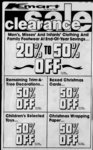
| OCR Text |
Show I I DAVIS COUNTY CUPPER, WEEKLY REFLEX 07:082:0020, Beg E 2015ft &S 27 deg. 34 W218.2ft:S35deg. 43 W 372.3 ft fr NW cor of SW Vt of Sec 1; T3N-R1SLM: & th S 35 deg. 43 W 327.5 ft; thN 54 deg. 17 W 570 ft; thN 48 deg. 20 E 337.5 ft; S 54 deg. 17 E 502 ft to pob. Cont, 3.675 Acres. Total Tax $26.07 James R. and Rosanne C. Bishop, 07:087:0012, All of Lot 12, Green Mountain Estates Sec 1, T3N-RISLM: Cont. .595 Acres. Total Tax ....$829.41 Richard V. and Lynne D. Clay, 07:087:0015, All of Lot 15, Green Mountain Estates Sec 1; T3N-R1SLM: Cont. .292 Acres. Total Tax $142.26 James E. and Colleen Baggs, 07:087:0023, All of Lot 23, Green Mountain Estates Sec 1 ; T3N-R1SLM: Cont. .287 Acres. Total Tax $750.01 David N and Tamara J. Phelps, 07:0089:0009, Lot 9, Tamara Est. Sub. and Sec 1, T3N-R1SLM, Cont. .52 acres. Total Tax $673.30 David N. and Tamara J. Phelps, 07:089:0010, Lot 10 Tamara Estates Sub amd sec 1, T3N-R1SLM: cont. 252 Acres. Total Tax $119.17 William P. and Kaaren N. Manning, 07:089:0014, Lot 14, Tamara Estates Sub, Sec 1, T3N-R1SLM: Cont. .253 Acres. Total Tax $575.73 Stephen W. and Judith V. Lindsey, 07:090:0017, Lot 17, Park View Est. No. 1, Sec 1, T3N-R1SLM: Cont. .253 Acres. Total Tax $1,019.63 V. K. and Ruth H. Snow, 07:090:0038, All of Lot 38, Park View Estates No. 3, Sec SLM: Cont. .30 1; T3N-R1Acres. Total Tax $124.38 Aztec Const. & Insulation, etal, 07:090:0060, All of Lot 60, Parkview Estates No. 4, Sec 1, T3N-R1SLM: Cont. .23 Acres. Total Tax ....$119.17 Michael J. and Kaiulani Roderick, 07:092:0049, All of Lot 49, Eas-toaPlatC. Sec 1;T3N-R1W- ; SLM: Cont. .50 Acres. Total $515.10 Tax William A. and Evelyn L. Johnson, 07:093:0008, Apt 8, Unit B, Somerset Place Cond. Sec 1;T3N-R1W- ; SLM: Total Tax $433.47 Janis D. Van Pelt Plattis, 07:093:0055, Apt 55, Unit O, Somerset Place Cond. Sec 1; T3N-R1SLM: Total Tax $409.64 Robert Mac and Yoshiko Calder, 07:094:0014, Beg on Ely In of old BERR sd pt being N 0 deg. 28'39 W 5.0 ft toward a witness cor & N 89 deg. 3630 E 867.50 ft &N 19 deg. 0153W 381.37 ft fr W' cor of Sec 2, T3N-R1SL: th S 42 deg. 33'08" E451.19ftalg sdETyln of RR; th S 53 deg. 15 10,rW 95 ft, mol, to ETy In of a hy; th N 42 deg. 28 W 447.83 ft algsd ETy In to pt S 47 deg. 32' W of pob th N 47 deg. 32' E 95 ft, mol, to pob. Cont. .979 Acre. $6.67 Total Tax Robert Mac and Yoshiko Calder, 07:094:0017,Beg on ETy In of old BERR sd pt being N 0 deg. 28'39" W 5 ft toward a witness cor & N 89 deg. 3630 E 867.50 ft &N 19 deg. 01 53 W 381.37 ft frW', cor of Sec 2, T3N-R1SLM: th N 62 deg. 44 35 E 273.20 ft to ETy In of Kays City, th S 42 378.7 ft alg sd ETy In; th S 52 deg. 10 W 264.9 ft to sd RR R-In; th N 42 deg. 28' W alg sd In 447.40 ft to pob. Cont. 2.512 Acres. Total Tax $357.16 Robert Mac and Yoshiko Calder, 07:094:0019, Beg at pt on ETy In of Kaysville City sd pt being N 0 deg. 28'39 W 5 ft toward a witness cor & N 89 deg. 36'30 E 867.50 ft &N 19 deg. 01 53 W 381.37 ft & N 62 deg. 44 35 E 273.20 ft fr W' cor of Sec 2 T3N-R1SLM: th N 62 deg. 4435 E 205 ft mol, to most 557-81- 4; W'ly cor of ppty conv by E th S 42 deg. 3308 375.95 ft; th S 52 deg. 10 W 195 In ft, mol, to ETy of Kays City; th N 42 deg. 28 W 378.7 ft alg sd In to pob cont. 1.645 Acres. $30.22 Total Tax Robert Mac and Yoshiko Calder, 07:094:0020, Beg N 0 deg. 28'39 W 5 ft toward a witness cor & N 89 deg. 3630 E 867.50 ft toward cen of sec & N 19deg. 0153" W 381.37ft &N 62 deg. 4435" E 454 ft fr WV4 W; SLM: cor of Sec 2, T3N-th N 62 deg. 4435"E 125.53 ft alg a fen th S 35 deg. 45'43 E 64.66 ft alg a fen; th N 73 deg. 02'03" E 488.33 ft alg a fen; th S21 deg. H51"E 198.94 ft alg a fen extend; th S 63 deg. 52' 14" W 370.60 ft alg a fen; th S 53 deg. 15" 10 W 126.60 ft; th N 42 deg. 3308W 375.95 ft to pob. cont. 3.28747 Acres. Tot- Id Tax $18.89 Webbs Canyon Dev. Corn., 07:098:0004, All of Lot 4, Sec SLM: Alta 2. T3N-R1Acres. Cont. .23 Acres. Total $110.41 Tax Webb's Canyon Dev Corp., 07:098:0005, All of Lot 5, Sec SLM; Alta 2. T3N-RIAcres. Cont. .23 Acres. Total $110.41 Tax Webb's Canyon Dev. Corp., 07:098:0006, All of Lot 6 Alta Acres Sec 2; T3N-R- 1 W; SLM: Cont. .23 Acres. Total Tax $110.41 Dev. Corp., 07:098:0007. All of Lot 7, Sec SLM: Alta 2, T3N-RIAcres. Cont. .23 Acres. Total $110.41 Tax Dean W. and June Lamoyne Avery. 07:098:0008, All of Lot 8. SLM: Alta Sec 2. T3N-R1Acres. Cont. .23 Acres. Total $556.49 Tax Webbs Canyon Dev. Corp.. 07:098:0010, All of Lot 10, Sec Webbs Canyon 2, T3N-RI- SLM; Alta Acres. Cont. .23 Acres. Total $U0.41 Tax Webbs Canyon Dev. Corp., 07:098:001 1. All of Lot II. Sec I W; SLM: Alla Acres 2, T3N-Cont. .24 Acres. Total Tax $110.41 Dev. Corp., 07:098.0012, All of Lot 12, Sec SLM: Alta 2, T3N-R1Acres. Cont. .23 Acres. Total $1 10.41 Tax Webbs Canyon Dev. Corn., 07:098.0013, All of Lot 13, Sec SLM: Alta 2, T3N-RIAcres. Cont. .23 Acres. Total $1 10.41 Tax Webb's Canyon Dev. Corp., 07:098:0015, All of Lot 15, Sec SLM: Alta 2, T3N-RIAcres, cont. .23 Acres. Total $110.4! Tax Webbs Canyon Dev. Corn., 07:098 .0016, All of Lot 16, Sec Webbs Canyon 2, T3N-R1- SLM; Alta Acres. Cont. .23 Acres. Total $110.41 Tax Rick and Denise Berriochoa, 28, t Cherrywood, Sec 2; . T3N-R1- 173 Acres. Total Tax $640.97 Ivory and Company, 07:101:0006, All of Lot 6 Creek View Est. Sec 2, T3N-R1SLM, Cont. .28 acres. Total Tax.. $113.95 Barney J and Cozette Carlson. 07:101:0021, All of Lot 21, Creek View Est. Sec 2, T3N-R1SLM, Cont. .37 acres. Total Tax $719.48 Mont and Gloria Jeane Rosenberg 07:101:0024, All of Lot 24, Creek View Est. Sec 2, T3N-R1SLM, Cont. .28 acres. Total Tax $113.95 Ivory and Company, 07:101:0033, All of Lot 33, Creek View Est. Sec 2.T3N-R1SLM, Cont. .28 acres. Total Tax . . $1 13.95 Arjen W and Nada H Jager, 07:101:0034, All of Lot 34, Creek View Est. Sec 2, T3N-R1SLM, Cont. .38 acres. Total Tax $124.38 Arjen and Nada Jager, 07:101:0035, All of Lot 35, Creek View Est. Sec 2, T3N-R1SLM. Cont. .28 acres. Total Tax $592.12 Ivory and Company, 07: 101:0053, All of Lot 53, Creek View Est. II, Sec 2T3N-R1SLM, Cont. .28 acres. Total Tax $113.95 Ivory and Company, 07:101:0059, All of Lot 59, Creek View Est. II, Sec 2T3N-R- 1 W, SLM, Cont. .28 acres. Total Tax $113.95 Roland F and Karen L Clift, 07:101:0066, All of Lot 66, Creek View Est. II, Sec 2T3N-R1SLM, Cont. .33 acres. Total Tax $630.10 Gayle C and Dee Ann H Johnson, 07:101:0069, All of Lot 69, . Creek View Est. II, Sec 2T3N-R1SLM, Cont. .36 acres. Total Tax $633.08 Ivory and Company, 07:101:0084, Part of Lot 3, 4, 5 of Creek View Est No. 1 Sec 2 T3N-R1SLM, a part of sd lots lying S of fence In located as follows: Beg 7.6 ft N of SE Cor of sd Lot 5 th N 89 degrees 1651" W300fttoapt 12.1 ft N of SW Cor of sd Lot 3 Cont. .07 acres. Total Tax $6.70 Keith 0 and Afton Robinson, 07:101:0087, All of Lot 3, Creek View Est. Sec 2, T3N-R- 1 W, SLM: cont. .28 acres except, beg at S W Cor of sd Lot 3 Creek View Estates th N 0 degrees 0853W 12.1 ft thN 89 degrees 16T5 E 100 ft th S 0 degrees 0853E 10.59 th S 89 degrees 51'07W 100 to POB Cont. .03 acres, balance cont. .25 acres. Total Tax . . $653.19 Prowswood Bldg Components Inc, 07:104:0002, All of Lot 2, Hillside Meadow, Sec 31, T3N-R1SLM, Cont. .203 $666.88 acres. Total Tax Stephen M and Michele M Miller, 07:104:0020, All of Lot 20, Hillside Meadow, Sec 31, T3N-R1SLM, Cont. .255 acres. Total Tax $491.34 Mark H and Susan Dickerson, 07: 104:0025, All of Lot 25, Hillside Meadow; Sec 31, T3N-R1SLM, Cont. .288 acres. Total Tax $616.49 Prowswood Inc., 07:104:0028, All of Lot 28, Hillside Meadow, 1 Sec 3 1 , T3N-E, SLM , Cont. .228 acres. Total Tax $163.78 L Doreen Foster, 07:106:0017, Beg at SW Cor of Lot 1, Foster-Heath I: 2; Sec 2, T3N-R1SLM: th ETy 5.45 ft alg cur to right alg N'ly In of St th N 27 degrees 48'E 187.4 ft to N'ly In sd Lot 1; th W 23.91 ft to NW Cor sd Loti, th S 22 degrees 123.39 ft to POB. Cont. .04 $3.71 acres. Total Tax William C and Robin C Gayler, 07:107:0015, All of Lot 15, Park Heights, Plat A Sec 35; T4N-R1SLM, Cont. .302 $510.93 acres. Total Tax Terry R and Cynthia C Gaston, approx 1830W 07:108:0038, All of Lot 38, Rolling Greens Sub. No. 2, Sec 2, T3N-R- 1 W, SLM, Cont. .208 $671.35 acres. Total Tax Steven B and Deborah Knecht, 07:108:0059, All of Lot 59, Rolling Greens Sub. No. 2, Sec SLM, Cont. .21 2, T3N-R1$497.95 acres. Total Tax Jack C and Patsi L Miller, 07108:0061, All of Lot 61, Rolling Greens Sub. No. 2, Sec W, SLM, Cont. .214 2, T3N-R$808.43 w acres. Total Tax Black's Title and ABS Co. Trus- tee, 07:109:0010, All of Lot 10 Upland, Sec 2. T3N-R1SLM, Cont. .245 acres. Total $127.45 Tax Jack and Karen D Evans, 07:109:0013, All of Lot 13 UpSLM, land, Sec 2, T3N-R1Cont. .380 acres. Total $860.30 Tax Keith R and Pamela L Davis, 07:109:0030, All of Lot 30 UpSLM. land, Sec 2, T3N-R1Cont. .355 acres. Total $695.06 Tax Intermtn Equities Corp., 07:110:0015, All of Lot 22B AMD Aegean Village Plat B SLM Cont Sec 31, T3N-R1.094 acres. Total Tax . . $86.51 George H Black Co., 07:1 10:0017, All of Lot 23 B AMD, Aegean Village Plat B, Sec-3- T3NR1E, SLM Cont. .094 $86.51 acres. Total Tax Intermtn Equities Corp, 24B 07:110:0019, All of Lot AMD Aegean Village Plat B Sec 31 T3N-R1SLM, Cont. .092 acres. Total Tax . . $86.51 Intermtn Equities Corp., 07:110:0034, All of Lot 32B AMD Aegean Village Plat B SLM Cont. Sec 31.T3N-R1E- , .094 acres. Total Tax . . $86.51 George H. Black. 07: 1 10:0036, All of Lot 33B, AMD. Aegean Village Plat B, Sec 31. T3N-R1SLM. Cont. .092 acres. Total $86.51 Tax George H Black, 07:1 10:0038, All of Lot 34B, AMD Aegean VilT3N-R1lage Plat B. Sec 31. SLM, Cont. .092 acres. Total $86.51 Tax Piute Home Corp of Utah, 07:110:0048, All of Lot 39B, AMD, Aegean Village, Plat B. Cont. .094 Acres. Total $86.51 Tax George H Black. 07: 110:0053, All of Lot 42 B AMD Aegean VilT3N-R1lage Plat B Sec 31, SLM, Cont. .098 acres. Total $86.51 Tax Intermtn Equities Corp., Ae- All of Lot 2. gean Village Plat A Sec 31; T3N-RISLM, Cont. .215 $346.04 Acres. Total Tax Inter Mountain Equities Corp., 07:110:0056. All of Lot 3, Aegean Village Plat A. Sec 31, 07:110.0055. T3N-RI- PAGE NINE DAVIS NEWS JOURNAL, DECEMBER 30, 1981 07L099:0028, All SLM: Cont.-- f SLM, Cont. .195 $163.78 acres. Total Tax Inter Mountain Equities Corp., 07:110 0063, All of Lot 10, Aegean Village Plat A Sec 31, T3N-R1SLM, Cont. .195 grees 47'50"E 215.50 ft to the POB cont. .739 acres. Total acres. Total Tax $173.02 D Maxine Miner, 08:037:0062. All 08:025:0014, Beg 12.01 Chs S 1492.72 ft N 3 degrees Meadows, of Lot 62, Oakridge Village No Farmington and N 77 degrees 30W 7.51 45'E 87.1 ft R SW CorofNW $481.89 Tax 08:041:0032, Beg at apt 1001.1 SLM, 6, Sec 11, T3N-R1Chs ffNE CorofNW'. of Sec SLM Cor of Sec 3, T3N-R1S 0 degs 03 degs W and N 89 Ivory and Co., 08:035:0043, All of cont. .224 acres. Total sd pt being cent of rd th N 3 10, T3NR2W, SLM, th SO deLot 43 Hess Farm Est. No. 1 degs 57W 546.9 and S 0 degs Tax 17 $1,113.71 S deth 9.97 85 S I5'E 100 Chs; th 45E grees degrees 03W 1071 and S 89 degs Sec 11, T3N-R1SLM, Oakridge Vill. Homeowners degrees 52E 3.38 Chs; th S 29 grees 53E 180.41 ft th S 3 de53'16W 301' and N 0 degs Cont. .31 acres. Total of Pt to 08:037:0072, MOL 120 ft deAssoc., 50'E 85 100 th N 45W degrees grees $249.78 Tax 02'44W 72.40 fr N', cor of 11.T3N-R1SLM, ft 50 SE',Sec In th of a N 180.41 POB road; to 53'W Nly Wly grees SLM: run Sec 12: T3N-R1Ivory and Co., 08:035:0052. All of Desc as foils: Begat NECorof MOL alg arc of a 388.31 ft rad or cont .48 acres out of KA-41- 9 th NO degs 03E 171.70; th S Lot 52 Hess Farm Est. No. 1 Lot 56 Oakridge Vill No 6 (sd curve to right; th N 3 degrees Total Tax$456.46 81 degs 06W 414.44' MOL to SLM cont Sec. 11, T3N-R1In of Swinton pt being on E Mildred C Ensign, 08:003:0006, 5517"; thNEly 317.16 ft alg .23 acres. Total Tax . . $238.00 E'ly In of Somerset Hollow Lane) and run the N 4 1 degrees the arc of a 408.31 ft rad curve Beg at a pt N 13.71 Chs and N Sub; th S20 degsE 136. 13 ft: th McGhie Land Title Co., th S 48 degrees 4526"E 14; 85 degrees 30 W 4.48 Chs fr SE to right; th N 66 degrees 26'E 08:036:0004, All of Lot 4, Oak-ridWly 129.88 alg arc of a In of up 1434E 109.99 th S 42 de63 MOL to W'ly SLM Cor of Sec 4, T3N-R1T3N-R1572.42' rad cur to left: th S I Farms, Sec grees 1847W (record S 42 deRR; th NWly 510, MOL, alg and run th S 85 degrees 20W SLM, cont .205 acres. deg04E 168 MOLtoaN'Iy In In to apt S 77 deSd Wly grees 34'$$"W) 15 ft; th N 48 89.33 th S 34 degrees 4727E of Somerset Farm Sub; th N 84 $233.49 Total Tax degrees 1434"W 109.85 ft to 745.38 ft, th N 25 degrees grees 30E of POB, thN 77 dedegs 16E 122.21. th ETy McGhie Land Title Co., 08:036:- POB, cont. .038 acres also beg 44T3W 688.17 ft to POB. grees 30W 250, MOL, to 23 1 .73 ft alg arc of a 245.42' rad at NW cor of Lot 48, Oakridge POB. Cont. 5.385 acres. Total 005, All of Lot 5, Oakridge Less to r cont. .375 acres curto left; th ETy 125.7 algarc T3N-R1Vill No. 6 (sd pt being on E Farms, Sec Tax $32.10 or MOL, remaining of of a 173.45' rad cur to right; th In of Staynor Dr) and run the S SLM: Cont. .195 Acres. Total Tax $6.30 Bob B and Sidona Allred, N 71 degs 4005E 67.97 to 64 degrees OOW'E 231.32 ft; $231.81 Total Tax David M and Rayanna Faerber, 08:025:0017, Beg on E In of POB. Cont 2.701 acres. Total th S 16 degrees 50'58W (reMcGhie Land Title Co., 08:036:- NW', at a pt 50 ft perp dist 08:005:0015, All of Lot 15, Sec $104.15 Tax cord S 17 degrees 02'19"W) 006, All of Lot 6, Oakridge 3, T3N-RISLM, Cameron NEly fr NE Cor of NW', of Jack and Elaine Harvey Palmer. T3N-R116.21 ft; th N 64 degrees Sec 10, T3N R1W, SLM, th S 0 Farms, Sec Estate, Plat C cont. .23 acres. 08:042:0003. Beg N 89 degs 0000W 235.81 ft to apt in E SLM: Cont. .205 Acres. $108.19 Total Tax degrees 15E 9.96 Chs; th S 17 1022 E 815.54 from NW Cor In of Staynor Dr. rad bear $235.17 Total Tax Richard J and Carol A Yardley, degrees 52E 3.38 Chs; th S 29 of NE', of Sec 13; T3N-R1N 55 degrees 1006" W th McGhie Land Title Co., 08:036:- degrees 50'E 120, MOL, to 08:006:0064, All of Lot 64 SLM: th S 1 deg 2253W T3N-R1Ne'ly alg a 230 ft rad cur to left 007, All of Lot 7, Oakridge George H Black and Co., NWly In of a road, th N'ly 50 Gailey Plat D Sec 382.86: th S 20 degs 3135" E T3N-R116.12ft POBcont. acres .086 to ft 07:110:0099, All of Lot 42, 388.31 Sec of a .31 Farms, acres. SLM Cont. ft, MOL, alg arc 209.11; thN 89 degs IO22E .124 Total acres. total de.215 3 Acres. AMD, Aegean Village Plat B. SLM: Cont. N rad th curve to $785.46 Total Tax right, 427.44 par to N Sec In: th N 0 $86.51 $18.48 Tax Total Tax $234.33 Total Tax grees 5517E 126.17 ft, th Henry L and G Lynnette Carter, 08:038:005 All of Lot degs 08'26W 579.49 ft to sec 44. 08:036:. KUTV. a Land Title David M Merrell, ETAL, McGhie of ft 317.16 arc Co., the NE'ly alg 08:007:0037, All of Lot 37, In; th S 89 degs I0'22"W 490. 1 1 Vill. Sec No. 11, 5, N Lot 07:112:0001, All of Lot All T3N-R1408.31 th of Oakridge 8, rad to curve Oakridge 008, 3 right; Gailey Plat C Sec ft to POB. Cont 6.24 acres. T3N-RIT3N-R1SLM .239 Woodland Springs Sub Plat B Cont. Sec to 66 63 MOL 26'E Farms, .21 Total SLM Cont. acres. degrees $2.98 Total Tax $240.21 Tax Total Sec 30 T3N-R1acres. .215 SLM: Cont. SLM, Cont. Acres. the In UP of RR, Tax $643.93 Wly R Parker, 08:043:0011. Totai Tax Vivian V Lodder, .26 acres. PT or and George $234.33 Johannes sd 510 MOL, ft, alg Mark A and Kathleen H Sperry, NWly Beg on S'ly In of a rd at a pt PT FA-- 65-- 3 or 08:038:0051, All of Lot 51. McGhie Land Title Co., 08:036:- In to apt S 77 degrees Wly 08:008:0054, All of Lot 54, 125.4 N and N 37 degs 50W Total Tax... $25.20 30 E of POB, th N 77 degrees 009, All of Lot 9, Oakridge Oakridge Vill. No. 6. Sec 11. Palos Verdes Est. Plat B Sec 570.2' alg ETy In of a hy fr SE T3N-RIT3N-R1SLM cont. .475 David M Merrell, ETAL, T3N-R130'W 250, MOL to POB. Farms, Sec SLM Cont. .23 Cor of SW', of Sec 12: acres. Total Tax ...$1,043.16 07:1 12:0002, All of L SLM: Cont. .215 Acres. Cont. 5.385 acres. Total acres. Total Tax $743.22 thN 39degs21W Woodland Springs Sub t $234.33 John A Hall, 08:038:0053. All of Total Tax $11.92 Tax Bafco Inc., 08:010:0017, Beg at a 180 MOLalg ETylnofsdhy to 08:036:-01Plat B Sec 30, T3N-R1Lot 53, Oakridge Vill. No. 6 SLM, Land Title McGhie B Co., and Bob S 1320 Sidona 24'W Allred, 0 alg degrees pt Cont. .23 acres. Total SLM. Sly In of Ppty conv in book All of Lot 12, Oakridge Sec. II, T3N-R108:025:002 1 , Beg at a pt on E'ly the ' sec In to the cen of an T3N-R1$21.84 Tax page 528 of deeds: th cont. .412 acres. Total In of DRG&W RR, sd pt Farms, Sec exist creek; th S 56 degrees W $265.41 NEly 233 ft MOL alg S ly In of Tax SLM: Cont. .195 Acres. David M Merrell, ETAL, 228.13 alg the center of sd being 160 ft , MOL, N & N 34 sd Ppty to Wly In of former Edward Steele. 08:040:0002. Unit $231.81 Total Tax 07:112:0003, All of Lot 3B creek and S 46 degrees 30W degrees 55 W 361.57 ft alg sd th SEly 180 ft berr RR Woodland Springs Sub Plat B 2, Bldg A Oakridge Vill. Cond. In fr cen of sec 10, T3N McGhie Land Title Co., 08:036:-01442.36 alg the center of sd Ely to Sly In of sd MOL alg sd Sec 19 T3N-R1Total Sec II, SLM, Cont. All of Lot 14, Oakridge creek and S 28 degrees 40E R1W; SLM, and run th N 34 T3N-R1rd; th S 52 degs 10W 211.7 ft .32 acres. Total Tax... $31. 08 Tax $1,353.08 Farms, Sec 3 7.48 fr the N'A Cor of Sec 4, degrees 55'W 252.23 ft th S 85 MOL alg sd rd to POB cont .80 David M. Merrill, ETAL, SLM: Cont. .195 Acres. Brian C and Sue S Swinton, T3N-R1SLM and run th S degrees 50' E 1.75 Chs, th N 1 acres. Total Tax ...$1,787.31 Unit 1. Bldg D. $231.81 08:040:0010, Total Tax 07:112:0005, All of Lot 5B 28 degrees 40E 125.43 thN 61 degrees E 0.89 Chs; to Wly In .aurence O and Loma E Price. Woodland Springs Sub Plat B McGhie Land Title Co., 08:036:-01of a rd; th S 25 degrees 40'E 32 Oakridge Vill. Cond. Sec 11, 1035 to the W'ly 20E degrees T3N-R108:043:0012, Beg at a pt N 0 Sec 19 T3N-R1SLM. Total All of Lot 16, Oakridge SLM, Cont. In of a rd; th N 23 degrees 15W ft, MOL, alg sd W'ly In, th Ely T3N-R1.36 acres. Total Tax . . . $34.44 degs 0736W 106.74 alg $310.25. Tax 21.6 ft; th S 26 degrees 50'E Farms, Sec 125.99 ft alg sd rd; th S 61 desec In to its pt of intersec with SLM: Cont. .225 Acres. David M Merrill, ETAL, Gerald W Davis. 08:040:0014. 183.61 ft tone cor of Ppty conv 20'W 1047.79 to the grees Vill, W'ly In of A hy and N 37 degs 2. E. $236.01 Unit Tax Total 07:112:0006, All of Lot 6B 55 Bldg S Oakridge th in Total degrees POB cont. 3.00 acres. 812267; 50W 180 algsdhyfrS',corof T3N-R1Woodland Springs Sub Plat B 08:036:Title Sec 11. Land McGhie Cond. cont. Co., POB 109.92 ft to 05W Tax $220.87 SLM: thN Sec 12, T3N-R1Sec 19 T3N-R1SLM. Total Tax.... $1,432.03 SLM, Cont. 0.60 acres MOL, alg the arc of 019, All of Lot 19, Oakridge Vem A and Carol Ann Winter, 37 degs 50W 89 alg sdhy; thN T3N-R1.36 acres. Total Tax . . . $34.44 J and Diane C Barlow, Sec to 236.58 rad to Farms, cur ft a Hugh W on right at a 08:010:0033, Beg pt 52 degs 10'E 237.48 to ETy In SLM: Cont. .54 Acres. David M. Merrill, ETAL, 08:040:0015, Unit 3 Bldg E. POB cont. 1.04 acres. Total In of D&RG RR wh is N 89 of ppty conv to Laurecne S Vill. Cond. Sec 11, $284.73 Total Tax $3.78 07:112:0007, All of Lot Oakridge Tax 1037.88 4631W alg degrees th S 42 Price ETUX in 449-6T3N-R1SLM. Total Woodland Springs Sub Plat B McGhie Land Title Co., 08:036:- B Allred, ' Sec In and N 34 B Bob Sidona and degrees degs 49E 59.84' alg sd ppty to Sec 19 T3N-R1$311.49 Tax SLM, Cont. 020, All of Lot 20, Oakridge 08:026:0016, Beg 1 19.46 ft N fr 315.15 ft alg sd W In 4050W SE cor thereof: th N 60 degs T3N-RI.39 acres. Total Tax . . . $37.80 Farms, Sec Roger Diehl, 08:040:0018, Unit 1. cen sec 10.TP3N RG1W.SLM frm E', cor of Sec 4; T3N-R130E 33.13 to Wly In of ppty SLM: Cont. .275 Acres. Bldg G. Oakridge Vill. Cond. Stephen M. Burton, 07:112:0008, 5 68 degrees 53'E 212.52 ft N SLM, th S 34 degrees of Lawrence E Welling ETux Total All of Lot $244.41 Sec 11, Total Tax Woodland 82 degrees 55'E 392 MOL to 104.27 ft the S 72 de4050E in 9 th S 42 degs 49E Tax $1,463.11 McGhie Land Title Co., 08:036:- Spring Sub Plat B Sec 19 T3N-R1NE'ly alg sd Wly In RR grees 2636" W 413. 10 ft to E In 15.64 alg sd ppty: th S 52 degs Gerald T and Terri Ann Lynch, SLM, Cont. .87 acres. 021, All of Lot 21, Oakridge of Sunset Dr.; th N 22 degrees Wly In RR 1063 ft MOL to cen 10W 276.80 to POB. Cont. .47 T3N-R1Total Tax 08:040:0019, Unit 2. Bldg G, I.. $82.31 In Sec S 1040 ft MOL to beg. Farms, Sec 22W 100 alg sd E In th N 72 $630.61 acres. Total Tax SLM: Cont. .245 Acres. Stephen M. Burton, 07:112:0009, Oakridge Village Cond. Sec II, Cont. 7.68 acres. Total 390.70' to 2636E degrees Don J and Julie K Leonard, T3N-R1SLM. Total Total Tax..-- , All of Lot 9B Woodland $239.37 $277.94 Tax POB cont. .92 acres. Total 08:043:0022, Beg a a pt S 57 Tax McGhie Land Title Co., 08:036:- $1,412.71 Springs Sub Plat B Sec 19 Tax $93.80 Gary D and Carol L Nelson, degs 56'W 607' fr the center of Robert A and Bobbie L Whitney, .95acres.Tot- 022, All of Lot 22, Oakridge 08:027:0003, A 50 ft wide H. Arthur and Evelyn L Johnson, T3N-R1SLM: th S Sec 12. T3N-R1al Tax $90.71 08:040:0031. Unit 2. Bldg L, Farms. Sec the West and No lines desc as 08:01 1:0001, Beg on an old fen 32 degs 04E 130 to NWly In Sec Cond. .23 Vill. W 11, Cont. Acres. SLM: ft and David M Merrill, ETAL, N 606.59 Oakridge foils: S E 832.47 ft and cor being Beg of Leonard Ln; th S 57 degs T3N-R1SLM. Total Total Tax $237.69 07:112:0010, All of Lot 10B 87.46 ft and N 70 degrees 36E 32.53 ft and S 37 degrees 56 W 56.72 to the pt of a cur; 08:036:Tax $275.69 Title Woodland Springs Sub Plat B McGhie Sec of Land cor Co., ft SW the 454.17 fr S ft 1812.53 and 40 00T0W th 52.36 alg the arc of 50 rad E and Karen L Spainhow-e- r, T3N-R1N Sec 19 T3N-R1- E SLM Cont. Donald Lot All of 6 23, th 023, Oakridge SLM, 10, 1771.30 ft fr degrees 1640E cur to the right; th N 62 degs T3N-R1Unit .54 acres. Total Tax... $5 1.23 2. Sec th 1514.12 Bldg 08:040:0033, Farms, ft, 35T4W NE cor of Sec 5. T3N-R1degrees 04W 63.52 to the pt of a 100 M , Oakridge V ill Cond. Sec 1 1 , SLM: Cont. .21 Acres. David M Merrill, ETAL, N 79 degrees 44 E 639.12 ft SLM, th N 41 degrees 15E rad cur (rad bears S 27 degs T3N-R1SLM. Total $234.33 Total Tax 07:112:0011, All of Lot 11B MOL to Wly In of county rd. 1575.14 ft alg an old fen In; th N 56'W 100) th NW'ly 104.72 Tax Woodland Springs Sub Plat B McGhie Land Title Co., 08:036:-04- 0, $1,361.48 cont. 2.44 acres. Total 40 degrees 03 W 86. 18 ft alg an alg the arc of sd cur; th N 57 Sec 19 T3N-R1- E SLM Cont. All of Lot 40, Oakridge $70.50 Tax Meadows, old fenc In th N 23 degrees Farmington T3N-R1.41 acres. Total Tax... $39.48 degs 56E 218.38' to the POB. 08:041:0005, Beg at apt 1001. 1 Farms, Sec 29' W 21 1 .92 ft alg an old fen In; Gary D and Carol L Nelson, cont. .384 acres. Total ft S 0 degrees 03'W and N 89 SLM: Cont. .23 Acres. David M Merrill, ETAL, W 08:027:0004, Beg at a pt N th S 58 degrees 3641 Tax $900.37 Total Tax $237.69 606.59 ft and W 87.46 ft and N 07:112:0012, All of Lot 12-degrees 57W 546.9 ft fr N' 427.29 ft, thS 41 degrees 15 W Foxglove, 08:043:0032, Beg at a pt Woodland Springs Sub Plat B Cor Sec 12;T3N-R1W- ; McGhie Land Title Co., 08:036:-04- 2, SLM, 70 degrees 36E 505.83 ft and N 1210.58 ft to an old fen In; th S on Sec ln S 89 degs 45'50W All of Lot 42, Oakridge Sec 19 T3N-R1SLM Cont. run th S 89 degrees 57 E 25 ft to 6 degrees 35T4"W 1289.98 ft fr 20 degrees 1640E 408.80 ft 1408.01' fr a Brass cap marking T3N-R1W In of Somerset Farm Sub; S .44 acres. Total Tax ... $42.00 Farms, Sec the SW cor of Sec 10, T3N-R- 1 alg an old fen In to POB. Cont. S', cor of sec 12; T3N-R10 degrees 0244" E 899.63 ft alg SLM: Cont. .195 Acres. David M Merrill, ETAL, 14.55 acres. Total Tax $709.45 W, SLM, run th N 6 degrees SLM, run th N 89 degs sd W In; th S 71 degrees 40'05" Total Tax $231.81 07:112:0013, All of Lot 13B 35T4W 165.70 ft to Sin of a Bafco Inc., 08:01 1:001 1 , Beg at a 4550"E139.67 ft alg sd sec In; W 26.35; N 0 degrees 03E Woodland Springs Sub Plat B McGhie Land Title Co., 08:036:-04- 7, th N 79 de50 ft private S 0 degrees 24W 1320 alg ' pt th N 0 degs 5440 ' E 208 36' ; th 907.91 MOL to POB. Cont. All of Lot 47, Oakridge Sec 19 T3N-R1SLM Cont. sec In of cen of an exist creek grees 44E 630 ft MOL alg sd S 89 degs 4550W 12.55 thN T3N-R1.47 acres. Total Tax... $45.35 .51 acres. Total Tax . . . $19.32 Farms, Sec to Wly In of a county rd; th and S 56 degrees W 228. 13' and 0 degs 1342W 280.21 to an .24 deCont. Hollow Acres. SLM: 79 N LTD Somerset Partner, rd to David M Merrill, ETAL, sd S 46 degrees 30W 442.36 alg apt SEly alg of existing fence th alg sd fence S NE Cor S Total th $238.53 Tax... 08:041:0006, E the of 44 of 07:112:0014, All Lot 14B Begat sd creek and S 28 degrees 40' E ' beg, pt grees 89 degs 54'32"W 468.85 to a W16 of NW1, of Sec 12:T3N-RIWoodland Springs Sub Plat B McGhie Land Title Co., 08:036:- 79 degrees 44W to the POB 734.27 and S 61 degrees 20W , steel rebar with an alumisec 19 T3N-- 1 E, SLM cont .5 1 SLM, run thS 1895.95 ft 050, All of Lot 50, Oakridge cont. 2.50 acres. Total 517.68 ft and S 38 degrees 17E fence In S T3N-R1num cap th alg sd MOL alg 40 acre In to a N'ly In Farms. Sec acres. Total Tax $47.87 $195.15 Tax 300 ft fr N ', cor of Sec 4, T3N- -. 21 degs 35T0E 422.60 MOL SLM: Cont. .25 Acres. of Somerset Hollow Sub; th N David M Merrill, ETAL, Anne R Sant, 08:027:0014, Beg in R1W, SLM, and run th S 61 to Nly In of ppty conv in 467-23- 7 1 Total Tax $177.14 the cen of a rd at a pt N 1322.05 degree 1845" W 431.04; th 07:112:0015, All Lot 15B degrees 20W 550 ft to E In of A N 0 degrees 0501 E 83.79'; th being a pt 20' Nly fr Nly Woodland Springs Sub Plat B McGhie Land Title Co., 08:036:- ft alg sec in and W 1464.86 ft road th S 38 degrees 17'E and limited access In hyw N1 degree 0837W 801. 31; th Sec 30 T3N-R1SLM cont 051, All of Lot 51, Oakridge from the S' cor of Sec 10, 169.19 ft alg sd road; th S 36 T3N-R1of project No. 123 th S 87 degs T3N-R1.55 acres. Total Tax . . . $52.07 NO degrees 5625W 222.41; Farms, Sec SLM. and run the degrees 29 E 195.93 ft alg sd 3950"E 181.63 alg sd In to a pt thN 1 degree 262!W 199.25; SLM: Cont. .25 Acres. N 9 degrees 02'W 105' alg the David M Merrill, ETAL, road to N In of another road; th S 2 degs 32'50 W fr POB th N 2 $240.21 Total Tax thN 62 degrees H20" W 75 cen of sd rd; th S 69 degrees 07:112:0016, All Lot 16B N 45 degrees 24E 528.78 ft. McGhie Land Title Co., 08:036:-05- 3, degs 3250" E 342.81 ft MOL MOL thN 47 degrees E 191.40 Woodland Springs Sub Plat B 1907E 168.54 ft; the N 3 deMOL, alg N In of sd road to a pt to pob cont. 7.4065 acres. Total All of Lot 53, Oakridge Sec 30 T3N-R1SLM cont. to POB. Cont. 1.008 acres. S32 degrees 13EofPOB;thN grees 14E 155.33 ft; th S 87 T3N-R1Tax $355.28 Total Tax Farms. Sec $38.64 .29 acres. Total Tax . . . $27.72 32 degrees 13W 216. 18 ft MOL degrees 27E 159.72 ft; th S 3 SLM: Cont. .21 Acres. Foxglove, 08:043:0033, Beg at an David M Merrill, 07:112:0017, All Somerset Hollow LTD, to POB cont. 3.70 acres. Total degrees 14W 205.40 ft; th N 87 intersec of two fen lines, 484 N Total Tax $234.33 08:041:0007, Beg at a pt S 47 Lot 17B WKOODLAND Tax $133.45 degrees 37W 298.21 ft to the and 811.34 W of a brass cap POB cont. 1.00 acres. Total degrees W 191.40' MOL to Dyal E. and Marie B. Stone, Springs Sub Plat B Sec 30T3N-R1- E James K and Diana R Earl, All of Lot 58. Oakmarking S', cor of Sec 12; SLM Cont .46 acres. Tot$747.01 Tax 08:01 2:0024, Beg on the W In of NEly In of Ppty conv by 469-1- 2 T3N-R- 1 T3N-R1544 51 al Tax W; SLM: th SW cor of and S 62 degrees 11'20"E " Bob B and Sidona B Allred, ridge Farms, Sec at apt N 89 degrees the RR 'M i' 1 sd Sec 12 bears S 89 degs In and S 5 1 .22 Acres. Cont. MOL S SLM: fence 75' to a Rds 41.25 David M er r , E T A L , 1037.88 sec the ft 08:028:0017, Beg 4631W alg 45'50"W fr sd ' cor, sd pt is a Total Tax $867.62 and 574 EfrNWcorSE',Sec degrees 12' 40W 478.76 ft alg a 07:112:0018, All Lot 18B In and S 34 degrees 40'50"E steel rebar with an alumifence In as desc by Bndry In McGhie Land Title Co., 08:036:-006- 0, Woodland Springs Sub Plat B 10 TP3N, RG1 W, SLM, SD pt 1126.84 ft alg sdW In fr the 3' num cap and run th alg an exand S 42 degrees All of Lot 60, Oakridge Sec 30 T3N-- 1 E SLM cont .42 In of D&RG agree 468-53- 0 SLM. cor of sec 4; T3N-R1being on E'ly T3N-R134'W 200.73 alg sd fence In; S isting fen In S 89 degs 5432"W acres. Total Tax $40.32 N 35 degrees 00 W 446 RR Farms, Sec and th S 34 degree 40'50"E 467.34 ft; th S 0 degs 1342E 41 degrees 20W 1 17 5.77 to a SLM: Cont. .22 Acres. David M Merrill, ETAL, 112.82 ft alg sd R-th N 89 ft, N55 degrees 00E 21.6 ft. N 280.21; th N 89 degs 4550E Total Tax $235.17 35 degrees 00W 241 ft, N 55 pt on W In of Sec 12, fr NE Cor 07:112:0019, All Lot 19B degrees 4430" W 784.56 ft to th 467.50 ft to a steel rebar and an of W'j of NW'. of Sec 12; McGhie Land Title Co., 08:036:- Woodland Springs Sub Plat B E In of Sunset Dr, th N 22 dedegrees 00E 47 th N 78.52 T3N-R1aluminum cap on an exist fen SLM: run th N 41 SLM cont. Sec 30 T3N-R1- E 0062, All of Lot 62, Oakridge MOL to sec In, E 315.3 ft N 38 grees 06 W 100 ft alg sd E In, th T3N-R1In; th alg sd fen N 0 degs .34 acres. Total Tax .. . $32.76 Farms, Sec S 89 degrees 44'30E 757.99 ft degrees 20'E 160' MOL to degrees 50'E 40 ft to W'ly In of 1544W 279.03 to th POB. SLM: Cont. .22 Acres. th SE'ly alg sd L'PEE David M Merrill, ETAL, Wly In of Somerset Hollow to the POB. Cont. 1.75 acres Cont. 3.00 acres. Total Total Tax $235.17 101 1 ft to pt due E of beg. Th W sub; th S 14 degrees W 50 07:112:0020, All Lot 20B together with and subj to 60 ft Tax $144.46 MOL to an angle cor there-in- ; McGhie Land Title Co., 08:036:- Woodland Springs Sub Plat B 592 ft to beg. cont. 8.13 acres. $533.19 Total Tax th S 14 degrees E 168.98 to $56.17 Foxglove08:043:0034, Beg at SW SLM cont .34 Sec 30T3N-R1- E 0063, All of Lot 63, Oakridge Total Tax Mary Lowe and Wayne Foulger, T3N-RIcor of Lot 9, Moon Park Sub., Farms, Sec acres. Total Tax $30.24 N'ly In of a st; th W'ly 140' alg 08:013:0004, ME', of MW', of L Henry and Virginia B Seamade-n- i, sd sub is located in S W of Sec sd Nly In to sec In; th N 35' SLM: Cont. .22 Acres. RG1 W SLM cont David M Merrill ETAL, Sec 5.TP-3All of Lot 17, 08:030:0017, SLM: run thN 12, T3N-RITotal Tax $235.17 MOL to POB, Cont. .289 40.18 acres. Also beg NW Cor 07:112:0021, All Lot 21B Palos Verdes Est. Plat A Sec I McGhie Land Title Co., 08:036:-007- 0, $11.76 acres. Total Tax deg 30'E 132.0'; thN 21 degs Woodland Springs Sub Plat B of NE1. of Sec 5, TP3N T3N-R10, Cont. SLM, 15E81.72 alg Wly InofMoon All of Lot 70, Oakridge SLM cont. Sec 30 T3N-R1Somerset Hollow LTD, RG1W,SLMS15E 15.50 Chs, .220 acres. Total Tax $1 10.41 T3N-R1Park sub; th N 89 degs .31 acres. Total Tax . . . $30.24 08:041:0008, Beg a apt 872.60 Farms, Sec N 52 degrees 30E12ChsN39 Val Dee and Margie R Walton, 38'50W 483.03; th S I deg SLM: Cont. .22 Acres. ft S and S 68 degrees 20 E David M Merrill ETAL, degrees 40 W 10.80 Chs W 2.70 08:030:0031. All of Lot 31, 30W 208.36 to a pt on sec In Total Tax 440.35' and S 41 degrees 20'W $235.17 07:112:0022, All Lot 22B Chs to beg. cont. 8.52 acres exPalos Verdes Est. Plat A Sec wh is given as E 20.85 Chs fr McGhie Land Title Co., 08:036:-007- 2, 182.51 ft frNW Cor of Sec 12; Woodland Springs Sub Plat B remainder 37.176 T3N-R1cept 723-79- 3 Cont. SLM, T3N-R1SW cor of sd Sec 12; th S 89 All of Lot 72, Oakridge E SLM Cont .32 Sec 30 T3N-SLM, run th S 25 acres. Total Tax $244.88 .320 acres. Total Tax $610.58 T3N-R1$31.08 degs 3850E 455.4 to SW cor acres. Total Tax Farms, Sec Michael Ed and Susan J Anderdegrees 13W 59.81 ft to an P and Carol J Bake, Clay SLM: Cont. .21 Acres. of Lot 9, the POB. Cont 2.2 angle cor on Wly In of SomeDavid M Merrill ETAL, son, 08:014:0004, Beg on the 08:030:0069, Beg at a pt on Total Tax $234.33 rset Hollow Sub; th N 88 deaers. Total Tax SE In of a lane at a pt S 832.47 ft 07:112:0024, All Lot 24B $105.83 In of sd Lot 72, Sec 10, Bndy William R. and Cathy F. Bain, Woodland Springs Sub Plat B and E 32.53 ft to th Wly In of a grees W 25 MOL; th N 41 deFoxglove, 08:043:0035, Beg at the is S 38 wh T3N, R1W, SLM, SLM Cont. Sec 30 T3N-R108:036:0075, All of Lot 75. intersec of 2 fen Ins at a pt 484' grees 20E 67.49 MOL to coroad and S 37 degrees degrees 5308 W 30.14 fr E POB. Cont .017 acres. Total N and 811.34' W of the S', cor .36 acres. Total Tax . . . $34.44 Oakridge Farms, Sec 0010"W 1108.20 ft algsd lane cor of sd Lot and run the 6.99 ft T3N-R1SLM: Cont. .205 Tax $4.20 of sec 12, T3N-R- I W; SLM; th David M Merrill ETAL, fr the NE Cor of Sec 5, T3N-RIalg the arc of a 615.86 ft rad cur Acres. S Lee and Sandra D SO degs 1544E 279.03; thN SLM th S 37 degrees 07:112:0025, All Lot 25B Bumingham, to left through a central angle Total Tax $889.81 Woodland Springs Sub Plat B 89 degs 4550E 28.08' ; th N 21 0T0W 123 ft alg sdland;thS 08:041:0011, Beg 842.90 ft E fr of 0 degrees 39' (chord bears S 08:036:-007T3N-RI7, E Land Title 1 McGhie SLM cont. Sec 30 Co., the NW Cor of Sec 12, T3N-R150 degrees 59' E 354. 5 ft ; th N degs 15E 223.02; thE 165; th 37 degrees 0930); thN 52 deLot All of 77, Oakridge .34 acres. Total Tax . . . $32.76 N 80.18, MOL, to a pt N 89 37 degrees 0T0"E 123ft thN 50 SLM, Th S 88 degrees 49W 36.86 ft; th N 37 grees T3N-R1Sec M Merrill ETAL, Farms, David 54E 201.73'; th S 47 degrees degs 54'32E of th POB. th S degrees 59 W 354.15 ft to th degrees IIE 7.0'; th S 52 de.21 SLM: Cont. Acres. 26B All Lot 89 degs 5432W 275.1" to the 07:112:0026. 2315 E 120; th S 62 degrees POB cont. 1.00 acres together grees 49' E 36.85 ft to POB, Total Tax $233.49 Woodland Springs Sub Plat B POB cont. .833 acres. Total Total Tax $385.88 with a 1120E 174.12; th S 51 deCont. .006 acres. Total 08:036:Land Title McGhie Cont. SLM Sec 30 T3NR1E Co., Tax Inez A Gast, 08:014:0009, Beg at a $47.87 grees 12'40"W 286.76 ft; th N Tax $3.71 Lot of All 1 1.80 Chs Sand 0.31 87, .26 acres. Total Tax . . . $25.20 0087, 52 degrees5l 'W 320.49; th N Oakridge of a Ch Kimball Lodder Inv. Co. Stephen Lamar and Clai Bennett, pt T3N-R1Sec M Merrill ETAL. 66 degrees 5850"W 137.93 ft Farms, David S 50 degrees 30'E of NE Cor of 08:044:0012, Beg at a pt N 08:030:0073, All of Lot 73, SLM: Cont. .195 Acres. to the Ely In of Ppty conv to 07:112:0027, All Lot 27B 1679.07 E 1421.66 and N 28 NEV. of Sec 5 T3N-R1Palos Verdes Est. Plat C, Sec Total Tax Woodland Springs Sub Plat B $231.81 Richard J White ETUX as enSLM, th S 37 degrees 15W 28 degs 0100"W 245' from the 10.T3N-R1W, SLM, Cont. .24 Land 08:036:Title McGhie SLM Cont. Sec 30 T3N-RICo., SE', cor of Sec 12.T3N-R1Chs; th S 38 degrees 30W try No. 315423; th NEly acres. Total Tax $109.67 .35 acres. Total Tax . . . $33.60 0088, All of Lot 88, Oakridge 189.51 alg sd Ppty to the POB. 16.35 Chs MOL th N 39 deSLM, and run the S 62 degs Kimball Lodder lnv. Co., T3N-R1M Sec W N Merrill 38 0.31 Chs; the Farms, David 59 00 W 158.44'; thN 28 degs Cont. 2.54 acres subject to ETAL, grees 40 08:030:0074, All of Lot 74, .195 28B Cont. All Lot Acres. SLM; N 16.35 and together 07:112:0028, 01W 250.85; th N 53 degs Chs; th Total degrees 30'E Palos Verdes Est. Plat C, Sec Total Tax Woodland Springs Sub Plat B $231.81 37 degrees 15'E 28 Chs, th S 50 Tax 43'E 151.13 ft; th S 28 degs $885.35 10, T3N-R1SLM, Cont .21 E SLM Cont .23 McGhie Land Title Co., 08:036:-009- 0, Sec 30T3N-01'E275tothe POB. Cont. .90 degrees 30'E 0.31 Chs to POB. acres. Total Tax Kenneth E Johnson, 08:041:0020, $105.96 Lot of All 90, $21.84 acres. Total Tax Total 2.33 acres. Oakridge Cont. acres. Total Tax $21.84 Kimball Lodder Inv. Co., Beg on E'ly In of hy at a pt T3N-R1Sec Farms, David M Merrill, ETAL, $23.92 Tax Hidden Quail Partnership, 280.5 N and 2108 MOL W of 08:030:0075, All of Lot 75, .185 SLM: All Cont. 29B Acres. Lot in 07:112:0029, Inez A Gast, 08:014:0010, Beg 08:044:0024, Beg at a pt S 89 Palos Verdes Est. Plat C, Sec SE cor of NW', of Sec 12, Total Tax Woodland Springs Sub Plat B $230.97 cent of st 11.8 Chs S and 0.31 T3N-RIdegs 05'50W 595.2 alg sec In 10, T3N-RISLM, Cont .19 SLM: th E 319 08:036:SLM cont. Land Title McGhie Sec 30 T3N-RI30 Co., NE S E 50 of Ch fr NE Cor of Sec 13, T3N-R1degrees acres. Total Tax $104.48 MOL to Ely fen of former of Lot All .24 acres. Total Tax .. . $23.52 S 37 0093, 93, 5. Sec Cor Oakridge 3NIW, SLM, SLM, th N 0 degs 31 Kimball Inv. Lodder Co. berr.thS T3N-RIWdegs56E 105.77; ; Rand R and Janice Kremer, Farms, Sec 4142W 601.31' th S 83 degs degrees 15W 28 Chs; S 40 deth N 80 degs 06E 13; th N 27 08:030:0083, All of Lot 83, .205 SLM: Acres. Cont. 37 N 07:113:0004. All of Lot 4, Wil11.27 E ft; degrees grees 555IW 754.42 thS 50 degs Palos Verdes Est. Plat C, Sec degs I4'E 62.01' to a pt N 0 Total Tax low Farm Est., Plat E Sec 31 $233.49 15'E 1850.06 ft to cen sd st; N 07T6"W 188.43 th S 15 degs 10, T3N-R- 1 W, SLM, Cont. . 19 degs 4745E 276.98 and S 86 T3N-R1- E McGhie Land Title Co., 08:036:- SLM cont. .53 acres 50 degrees 30"W 1 1 ft alg st to 13'25"E 389.12 th S 3 degs acres. Total Tax $104.48 degs 5128W 171.77 fr SE out of card CE 638-- 1 or 0094, All of Lot 94, Oakridge I8T7E 452.90 th N 86 degs beg. Cont. .46 acres. Total Thomas Layton, sd NW',;thN 86 Gregory CorofW'jof T3N-R1Sec 0054. Total Tax $100.06 Farms. $8.18 Tax 14T0"E 129.62 to NE cor of 08:030:0085. All of Lot 85, degrees 5128"E 171.77 alg an .24 SLM: Cont. Acres. and Brian Roseann Lot 17 AMD plat of Quail George Dean E and Susan J Tibbitts, Palos Verdes Est. Plat D, Sec old exist fen In to E In of W'2of Tax Total All of $238.53 07:113:0005, Schlutz, Cove, th N 6 degs 0030E 78 08:025:0008, Beg on E In of a 10, T3N-RIsd NW',; th S 189.04'; MOL, SLM, Cont .19 McGhie Land Title Co., 08:036:-009- 8, Lot 5 Willow Farm Est. Plat E acres. Total Tax thN84degs 12 24 E 145.69 th $541,67 to a pt N 0 degs 05W 233.95 county road as presently used of Lot All SLM cont. Sec 31 T3N-RI98, Oakridge S 7 degs 28'20E 27 th S 64 at a pt S 127.58 ft and E 670.29 Elwood Shifflett. 08:032:0010, W and 1320.2 Bnd S 0 degs T3N-R1.53 acres out of card Farms. Sec ft and N 21 degrees 3620W degs 28' E 78 th N 73 degs 5 1E Beg at a pt S 834.26 ft and W 05E 146.35 fr SE Cor of sd .225 SLM: Cont. Acres. Total or 167.99 th S 10 degs 0742E 226.76 ft alg E In sd road fr W', 791.80 ft fr the NE Cor of Sec NWV,; th S 67 degs 43W Tax Total Tax $898.16 $236.01 50.26 th N 82 degs 4435E cor sec 10;T3NRIW, SLM, th 11, T3N-RISLM, (th N'A 292.7', MOL, to E'ly In of sd 258.58 th N 1 deg 3355W McGhie Land Title Co., 08:036:-010- 0. N 68 degrees 2430"E 790.44 ft Cor of Sec 1 2 bean E of the N E Berr; th S 31 degs 53T0"E Kenneth and Julie D Selleneit, 320 th NO degs 4139W 37.7 1 1 N fence th 0 100 an Lot N Cor Sec to of of All th 10 cor.; 0 ); existing MOL. sd 48. degrees Oakridge alg 07:113:0008, All of Lot 8, WilEly In to cont. 17.516 acres out of FA-37- 8 T3N-RI07'54"E 120.30 ft alg an exist Farms. Sec NE Cor Ppty conv in 645-87degrees 17'20E 344.03 ft alg low Farm Est., Plat E, Sec 31, or Total SLM: Cont. .21 Acres. fen to apt; th N 86 degrees th S 70 degs 1228" W 57.93, existing fence; th S 68 degrees T3N-R1- E SLM Cont. .610 out Tax Total Tax 10'47 W 138.30 ft ; th S 55 de24'30W 918.73 ft to E In of $1,683.16 $234.33 MOL, to SE Cor of Ppty conv or of card CEN-64- 0 fence on sd roadway; th S 21 in 760-37Dennis T and Mary Sue Utley, grees 1 157W 237.07 ft MOL th NW'lyalg sd 0019. Total Tax $749.33 Hollow Somerset Ltd, to a pt wh lies on the E'ly hy In; degrees 36'20E 319.24 ft alg ppty 112.5 ft; th SWly 205, 08:037:0011, All of Lot II, Steven J and Alfred T Anderson, 08:045:0001, All of Lot I, Tot5.75 In POB S E acres. to th ft 1 1 sd 40 0947"E No. MOL, alg sd Ppty to E'ly In of degrees 2, Sec . Oakridge Village alg Somerset Hollow, Pud. Sec 12; 08:002:0064, Beg 88 degrees T3N-R1$856.12 sd hy In; th N 48 degrees al Acres T3N-R1SLM, cont. .335 Hwy; th N 26 degs 41'W 350, SLM. Total H E 1509.65 ft N 19 degrees B S deand Sidona 88 15'45"E 96.05 'h Bob ft., acres. Total Tax .. .$1,316. Allred, MOL, to the POB. Cont. 2.889 Tax 32' W 804.07 ft N 88 degrees $192.34 acres. Total Tax $163.78 Inter Mountain Equities Corp., 07:110:0076, All of Lot 22A and Aegean Village Plat B Sec J 31, T3N-R1SLM, Cont. .093 acres. Total Tax.. $86.51 Inter Mountain Equities Corp., 07:110:0078, All of Lot 24A AMD Aegean Village Plat B Sec 3 1 , T3N-- 1 E, SLM, Cont. .093 acres. Total Tax . . $86.51 George H Black Co. 07:110:0083, All of Lot 28A AMD Aegean Village Plat B. Total Tax$86.51 Inter Mountain Equities Corp., 07:110:0087, All of Lot 32 A AMD Aegean Village Plat B Sec31,T3N-RlE- , SLM, Cont. .094 acres. Total Tax.. $86.51 George H Black and Co., 07:110:0088, All of Lot 33A AMD Aegean Village Plat B. Total Tax $86.51 George H Black and Co., 07:110:0089, All of Lot 34 A AMD, Aegean Village Plat 3. $86.51 Total Tax 4045E ', ', V ', |