| OCR Text |
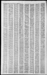
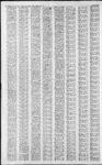
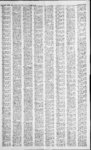
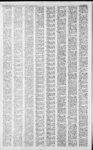
Show It DAVIS COUNTY CLIPPER, WEEKLY REFLEX DELINQUENT PROPERTY TAX LIST OF DAVIS COUNTY FOR THE YEAR 1981 Under the direction of the Board of County Commissioners of Davis County, State of Utah, I hereby give notice that the following named persons are delinquent in the payment of the 1981 State School, State Special District and City Property Taxes upon the property described and in the amount indicated. Unless said delinquent taxes, together with penalty are paid before 12 oclock noon on the 15th day of January, 1982 the real property upon which such taxes are a lien, excepting only such property as is held by the county under a prior preliminary tax sale, will be sold to Davis County, State of Utah for taxes. Dated this 29th day of December, 1981. Brokers Inc., 01:004:0003, The N'i E'2 of SW'4 Sec 4, T1N-R1SLM: Cont. 40.00 Acres. Total Tax $162.53 John R. Calder Trustee, 01:004:0004, BegataPtWhls S 4240 Ft MOL, AlgThSecLn and E 1060 Ft MOL, frTh NW Cor of Sec 4,T1N-R1E;SLSd Pt being Ely fr th N E Cor of an Old Cabin Concrete Fnd 20 Ft alg th Imag Ext of th remains of the N Wall of sd Old Cabin; Th Sly and Para to the E Fnd of sd Old Cabin Site, 55 Ft; th Wly and Para to th S Fnd of sd Old Cabin, 100 Ft; th N'ly and Para to the W Fnd of sd Old Cabin (also passing W of a Large Tree abt 3 Ft in Dia) 130 Ft MOL to th Ce Ln of the Old Unimproved Canyon Rd; th SEly alg sd Cen Ln 100 Ft, MOL, th leaving sd Cen Ln Sly and Para to the E fnd of sd Old Cabin 29 ft, MOL, to the POB Cont. .25 Acres. Total Tax $11.08 David R. and Gayle Evans, Th of 01:004:0018, N'i Th E 2.0 chs of th W 6.0 chs of the S'iofth SE'iofth SE Vi of Sec Cont. 2.00 4, Acres. Total Tax $58.41 Anthony Price, 01 :004:0019, All of the SVi, E 2.0 chs of W 6.0 chs of SVi of SE'A of Sec 4, T1N-R1SLM: Cont. 2.00 Acres. Total Tax $58.41 Margie Deen Johnson, Vi 01:004:0023,Th S of W 2 chs of the E 28 chs of th S Vi of the SE of Sec 4, TIN- - R1E, SLM; Cont. 2.00 Acres. Total Tax $29.21 Hugh L and Ella K Williams, 01:004:0028, Th W 2.0 Chs of the E 18 Chs of the SVi of the SE'A Sec 4; T1N-R1SLM; Cont. 4.00 Acres. Total Tax $58.41 Chelsea Dev Co., 01:005:0001, Beg at a Pt N 89 degrees 50'58E 485.551 Ft alg Sec Ln fr NW Cor of Sec 5 1N-1SLM: run th alg Wly Ln of Chelsea Cove th following courses and dist, S 14 degrees 53 59 'E 206.459 Ft th S 23 degrees 5003E 54 Ft th S 33 , degrees E 1 13.857 Ft th S 49 degrees E 320 182 Ft th S 45 degrees E 375.241 Ft, th S 57 degrees 0742 E 188.885 Ft to an Angle Cor on Nly Ln of Chelsea Cove 9-th S 6 degrees 27 W 254.842 Ft along th S 61 Wly Ln of sd Plat degrees 30W 282.0 Ft alg sd Wly Ln, th N 33 degrees 06 W 209.169 Ft th N 16 degrees 23W 114 Ft th N 32 degrees 44E 81.10 Ft th N 42 degrees 30 W 98.10 Ft th N 55 degrees 42W 99 Ft, th N 46 degrees 26 W 492.6 Ft th N 55 degrees 58 W 137.889 Ft th N 35 degrees E 200.222 Ft th N 28 degrees E 147 Ft th N 40 degrees E 155 Ft to POB. Cont. 10.413 Acres. Total Tax . . . $1,090.63 Chelsea Dev Co., 01:004:0002, Beg at a Pt 1428.284 ft S and 724.377 Ft W ft N'. Cor of Sec SLM: th S 3 de5, T1N-R1grees 30' E 100.001 Ft th S 86 degrees 30W 252.806 Ft th N 84 degrees W 115 Ft th S 74 degrees W 134.84 Ft th S 57 degrees llE 101. 152 Ft thS31 degrees 06E 1 10 Ft th S 1 degrees 53E 99.6 Ft, thS 29 deFt th S grees 08'02E 217.4 47 degrees 14E 316.30 Ft th S 81 degrees 05E 154.10 Ft th S 60 degrees 37E 382.20 Ft th S 69 degrees 17E 132.40 Ft thS 79 degrees 23'E80.3I Ft th S 60 degrees E 118 Ft th N 10 degrees 50'37 W 179 .789 Ft th N 60 degrees W 544 Ft th N 20 degrees W 700 Ft to the POB Cont 9.231 Acres Total $568.32 Tax Chelsea Dev. Co., 01:005:0003, Beg at the NW Cor of Sec 5 T1N-R1SLM: th S 107.7 Ft th S 38 degrees 07E 95.9 Ft, Th S 23 degrees 12E 83.2 FZTTH S 13 degrees E 98.1 Ft th S 55 degrees 58E 105.111 Ft thN 35 degrees E 200.222 Ft th n 28 degrees E 147 Ft th N 40 degrees E 1555 Ft to a Pt on S Ln SLM: th of Sec 32; T2N-R1N 89 degrees 5058W 325.821 Ft th N 60 degrees W 73.037 Ft th N 88 degrees W 40 Ft th S 2 degrees W 37.675 Ft; N 89 degrees 50 13 W 55.188 Ft to POB. Cont 2.75 Acres$414.60 '. Western Hold;ng Corp, 01:005:0004. Beg N 0 degrees 0842"W 882.47 Ft and N 89 degrees 51T8E 1220 Ft frTh W Vi Cor of Sec 5: T1N-R1SLM: run th N 89 degrees 5118"E 1.0 Ft to th W Ln of a St; th NO degrees 08'42W 120 Ft alg sd st; th S 89 degrees 5I'18 "W 1.0 Ft; th SO degrees 08 42E 120 Ft to the POB Cont. .003 Acres. Total $3.84 Tax A, Western Holding Corp, S wh Is Beg at a pt 0 degrees 0842' E 1969.32 Ft alg Sec Ln and E 1437.44 Ft and S 25 degrees 26' 02"E 104.01 Ft fr th NW Cor of Sec 01 :004:0008. 25 degrees 26'02E 7.53 Ft; th 30.69 Ft; S 75 degrees th S 55 degrees 3 1'42"E 229.12 Ft; th N 12 degrees 0138"E 124.16 Ft; th N 47 degrees 15'57W 103. 17 Ft: thN 29 de- 01I2E grees 0012W 55.84 Ft;thS56 degrees 2929W 173.65 Ft to th POB. Cont. .63 Acres. Total $66.85 Tax Robert H. and Katherine B.GarfT, wh a Is S 01:005:0010. Beg at pt 0 degrees 0842"E alg Sec Ln 1969.32 Ft and E 1437.44 Ft fr NW Cor of Sec 5; TIN-RIE- ; SLM. th S 25 degrees 26 02 E 104.01 Ft: th N 56 degrees 29'29" E 173.65 Ft; th 29 de A, grees 0012W 25 Ft; th S 82 degrees 2123W 178.92 Ft to POB. Cont. .25 Acres. Total 26.13 Tax Chelsea Dev Co., 01:005:001, Beg at a pt wh Is S 89 degrees 5058E alg Sec ln 2184.593 Ft and due S 2331.643 Ft fr NW SLM: Cor of Sec 5;T1N-R1E- ; sd Pt being on Arc of a 316.218 Ft rad Cur the Cen of wh Bears N 44 degrees 1239E; th SEly alg sd Cur to left thru a Central Angle of 14 degrees 4939 for a Dist of 81.834 Ft; thS 60 degrees 37E 16.979 Ft to a pt on N'ly Ln of Indian Springs Rd as Dedic in no Canyon Ests Plat C, sd Pt being on Arc of a 15 Ft Rad Cur th Center of wh Bears N 75 degrees 42'W; th NWiy alg sd Cur to left thru a Central Angle of 59 degrees 06'49 for a Dist of 15.476 Ft; th N 60 degrees 37 W 87.504 Ft to POB. Cont. .016 Acres. Tot$3.84 al Tax Lothar and Marilyn Nestman, 01:005:0015, Beg S 0 degrees 10'E 108 Ft alg Sec Ln and S 2528E 279.32 Ft and S 58 degrees 04E 242.60 Ft and S 44 degrees 5345E 412.05 Ft fr NW Cor of Sec 5, T1N-R1SLM: th S 3 degrees 49E 174.16 Ft to a Pt S 1077.22 Ft and E 516.11 Ft and N 42 degrees 48E 166.81 Ft fr sd NW Cor; th S 1 degree 2330E 104.58 Ft; th S 8 degrees 3625"E 86.33 Ft; th S 34 degrees 29E 71 Ft; th S 3 degrees 30 E 90.09 Ft; th N 55 degrees 04EW 111.56 Ft; th S 29 degrees 2550E 167.16 Ft; thN 44 degrees 4223E 316.56 Ft; N 33 degrees 0645W 5.98 Ft; N 9 degrees 5920W 22.69 Ft th N 26 degrees 2040 W 22.05 Ft; th N 22 degrees 25 41W 111.81 Ft; N 39 degrees 3523W 131.63 Ft; thN54 degrees 2701W 102.25 Ft; thN 45 degrees 56T0W 82.65 Ft to POB. Cont. 2.1 16 Acres. Total $156.20 Tax Margaret S. Lowder, 01:006:0806, All of Lot 806, Chelsea Cove Plat No. 8, Sec 32; T2N-R1SLM and Sec 5; T1N-R1Cont. .235 Acres. Total $203.87 Tax Utah Mtge and Loan Corp; 01:005:0909, All of Lot 909, Chelsea Cove Plat 9A. Sec R1E-1T1N-2SLM: Cont. .20 Acres. Total Tax $1,009.30 Utah Mtg and Loan Corp, 01:006:0910, All of Lot 910, Chelsea Cove Plat 9A. Sec 5, T1N-R1SLM: Cont. .19 Acres. Total Tax . . . $1,128.01 Win. A, Jr. and Jo Ann E. Wright, Etal, 01:006:0922, All of Lot 922, Chelsea Cove Plat No. 9A, Sec;TlN-RlE;SLCont. .23 Acres. Total Tax $1,054.25 Stuart M and Evelyn A Winegar, 01:006:0924, All of Lot 924, Chelsea Cove Plat No. 9A, Sec SLM; Cont. .52 5; T1N-R1$253.10 Acres. Total Tax Chelsea Dev. Co., 01:006:0925, Chelsea Cove Plat No. 9A, Sec 5: T1N-R1SLM: Cont. .70 $249.05 Acres. Total Tax R. Eric Peterson, 01:006:0927, All of Lot 927, Chelsea Cove Plat No. 9A, Sec 5; T1N-R1SLM: Cot. .28 Acres less: beg at the SE Cor of Lot 927 of Chelsea Cove No. 9A; and run th N 62 degrees W 14.47 Ft alog the Lot Ln; Th N 31 degrees 48'57" E 104.97 Ft to a Pt on th E'ly Ln of sd Lot; th S 23 degrees 54'45 W 105 Ft to th POB. Cont. .0174 Acres. Remainder Cont. .2626 Acres. $207.06 Total Tax R. Eric Peterson, 01:006:0928, All of Lot 928, Chelsea Cove Plat SLM: 9A, Sec 5; T1N-R1Cont. .24 Acres. Total Tax $1,323.77 Chelsea Dev. Co., 01:006:0935, Part of Lot 927 of Chelsea Cove No. 9A as follows: Beg at the SE Cor of Lot 927 of Chelsea Cove No. 9A, th N 62 degrees W 14.47 Ft alg th Lot Ln; th N 31 degrees 48'57" E 104.97 ft to a pt on the E'ly Ln of sd Lot; th S 23 degrees 5445" W 105 Ft to the POB. Cont. .0174 Acres. Total $3.73 Tax Corless W. and Linda L Mitchell, 01:008:0405, Lot 405, Chelsea Cove No. 4, Sec 5, TIN- - R1E; SLM: Cont. .51 Acres. Total $252.36 Tax Chelsea Dev. Co., 01:008:0408, Lot 408, Chelsea Cove No. 4, SLM: Cont. Sec 5, TIN-RI.49 Acres. Total Tax .$246.98 Scott D and Corry Candland, 01:008:0415, Lot 415, Chelsea Cove No. 4. Sec 5; TIN-TISLM: Cont. .45 Acres. Total Tax $1,021.19 Adams 4, Oakcrest Sub, Sec 5; TIN-RISLM: Cont. .48 Acres. Total Tax $224.53 Gary R and Connie W Lindsay, 01:01 1 :0007, All of Lot 7, Oakcrest Sub, Sec 5; TIN-RISLM: Cont. .28 Acres. Total Tax $207.55 Kelly W and Pamela D Willey, 01:011:0014, All of Lot 14, Oakcrest Sub, Sec 5; TIN-RISLM: Cont. .25 Acres. Total Tax $1,112.33 Norman and Susan Murphy, Etal, 01:012:0002, All of Lot 2, Indian Springs Est. Sec 5, TIN-RISLM: Cont. .28 Acres. Total Tax $207.55 Mtn West Dev. Co., 01:012:0005, All of Lot 5, Indian Springs Est. Sec 5, TIN-RIE- ;' SLM: Cont. .38 Acres. Total Tas $799.17 Terry G and Karen Lee, All of Lot 6, Indi01:012:0006, an Springs Est. "A, Sec 5, TIN-RISLM: Cont. .28 Acres. Total Tax $910.69 Terry G and Karen Lee, 01:012:0006, All of Lot 6, Indian Springs Est. Sec 5, TIN-RISLM: Cont. .28 Acres. Total Tax $223.06 Mtn West Dev Co., 01:012:0008, All of Lot 8, Indian Springs Sec 5, TIN-RIEst. SLM: Cont. .43 Acres. Total Tax $233.40 Mtn West Dev Co., 01:012:0015, All of Lot 15, Indian Springs Sec 5, TIN-RIEst. SLM: Cont. .49 Acres. Total Tax $243.74 Mtn West Dev Co., 01:012:0016, All of Lot 16, Indian Springs Sec 5, TIN-RIEst. SLM: Cont. .49 Acres. Total Tax $243.74 Mtn West Dev Co., 01:012:0023, All of Lot 23, Indian Springs Sec 5, TIN-RIEst. SLM: Cont. .3 Acres. Total Tax $226.75 Mtn West Dev Co., 01:012:0024, All of Lot 24, Indian Springs Sec 5, TIN-RIEst. SLM: Cont. .38 Acres. Total Tax $224.53 Mtn West Dev Co., 01:012:0029, All of Lot 29, Indian Springs Sec 5, TIN-RIEst. SLM: Cont. .28 Acres. Total Tax $207.55 John R and Betty H Call, 01:013:0003, All of Lot 3, North Canyon Estates Plat B Sec 5; TIN-RISLM: Cont .92 Acres. Total Tax $316.12 Clark Jenkins, 01:013:0006, All of Lot 6, North Canyon Estates Plat B Sec 5; TIN-RISLM: A, PAULINE McBRIDE, Treasurer of Davis Co. State of Utah Mortgage Henning Corp, 01:008:0416, Lot 416. Chelsea Cove No. 4, Sec 5, TIN-RISLM: Cont. .45 Acres. Total Tax $1,303.41 Robert B and Lillie C Arbon, All of Lot 519, 01:008:0519. Chelsea Cove No. 5 Sec 5 T1 SLM: Cont. .237 Acres. Total Tax $1,482.80 Gary G. and Dell Jean Cook, All of Lot 939, 01:010:0939, Chelsea Cpve Plat No. 9B, Sec SLM: Cont. .85 J. TIN-R1E- : Acres. Total Tax ... $ .357.78 Fred T and Bonnie Lee Romvn, 01:010:0949, All of Lot 949, Chelsea Cove Plat No. 9B, Sec SLM: Cont. .30 5, TIN-RIAcres. Total Tax... $1,101.65 Mark Robert and Kristine Brunson. 01:011:0001. All of Lot I, Oakcrest Sub, Sec 5; TIN-RISLM: Cont. .33 Acres. $216.41 Totai Tax Russell Lewis PAGE ONE DAVIS NEWS JOURNAL, DECEMBER 30, 1981 B and Monika Price, 01:011:0004, All of Lot A, A, A, A, "A, A, Cont .26 Acres. Total Tax $204.59 Clark Jenkins and Kay Peterson, 01:013:0010, All of Lot 10, North Canyon Estates Plat B Sec 5; TIN-RISLM: Cont Acres. Total Tax $322.77 . Wayne A and Linda G Cottrell, 01:013:0011, All of Lot 11, North Canyon Estates Plat B Sec 5; TIN-RISLM: Cont .70 Acres. Total Tax $279.19 Larry D and Donna R Keller, Etal, 01:013:0012, All of Lot 12, North Canyon Estates Blat B Sec 5; TIN-RISLM: Cont .25 Acres. Total Tax$l,336.13 Clark Jenkins, 01:013:0013, All of Lot 13, North Canyon Estates SLM: Plat B Sec 5; TIN-RICont .28 Acres. Total Tax $207.55 M W Dev Ltd, 01:015:0003, Beg a apt wh IS N 89 degrees 5803"E alg th Sec Ln 1478.56 Ft and S 1840.77 Ft fr th N', Cor of Sec 5, TIN-RISLM: (sd Va Cor bearing N 89 degrees 5438 E fr th N W cor of sd Sec 5, and being th basis of bearing for this desc) th S 78 degrees 45'09"E 156.81 ft; th S 28 degrees 4508"E 80 ft; th S 39 degrees 1452 W 125 Ft; th S 73 degrees I450W 130.07 ft; th N 44 degrees 1508W 102.41 ft; thN 63 degrees 5149E 44.21 ft; thN 16 degrees 5220E 148.58 ft to the POB CKONT. . &37. Acres Out of Bo 1800 or Total Tax.... $3.73 Mtn West Dev Co Inc., 01:016:0001, Beg at SE Cor of Lot 8, Indian Springs Ests Plat SLM: sd A, Sec 5; TIN-RICor being located A 0 degrees 0842E alg Sec ln 3157.48 Ft and S 52 degrees 40'30"E 103.13 Ft and S 77 degrees 28T6E 184.39 Ft fr NW Cor of Sec 5; th S 58 degrees 25E 1668 Ft th S 28 degrees 20 E 301 Ft thN 42 degrees 3038"E 599.61 Ft; th N 1 degree 2629E 1100.92 Ft MOL, to SW Cor of Lot 1, North Canyon Ests, Plat C; th N 458.95 Ft th N 31 degrees 3515W 46.31 ft to apt on a 150.65 Ft Rad Cur to to right (Rad Pt Bears N 31 degrees 3515W) th alg sd Cur 114.08 Ft; thN 78 degrees ll55"W 97.39 Ft to N E Cor of Lot I North Canyon Ests Plat B; th S 3 degrees 5455"E 344.80 Ft; thS 68 degrees 4821W 262.77 Ft; thN 72 degrees 4257W 574.69 Ft; thN 4 degrees 3426"E 235 Ft; th S 84 degrees 222IW 297.26 Ft to SE Cor of Lot 18. of aforemention Indian Springs Ests Plat A, th S 84 degrees 2221W 113.71 FVT:TH S53 degrees 3215E 494.22 Ft; th S 45 degrees 0520"W 289. Ft to apt on a 19 Ft rad Cur to right (sd Rad Bears N 44 degrees 5440"W) alg sd cur 62.01 Ft th S 8 degrees 08 , 34"E 199.25 Ft to POB Cont. 0 Cont. 43.00 Acres less 3.00 Acres remainder 40.00 Acres. Total Tax... $1,351. 64 Gark Jenkins, Etal, 01:016:0005, Beg at apt S 0 degree 0842E 549.88 Ft alg Sec Ln fr W', Cor SLM: run of Sec 5; TIN-RIE- ; th S 50 degrees I5'E 87.78 Ft to N'ly Ln of a St; th S 39 degrees 45'W 105 Ft to Sec Ln; N 0 degrees 0842W 136.57 Ft to POB. Cont .106 Ac. Total Tax $3.69 Kay Peterson, Etal, 01:017:0006, Beg at apt wh IS S 89 degrees 54'38"W 3.45 Ft and S 2357.32 Ft fr T N'. Cor of Sec 5; T1NR1E; SLM: (sd Va Cor bearing N 89 degrees 54' 38E fr th N W Cor of sd Sec 5; and being th basis of bearing for this Desc3 sd Ptalso being on th SW Bdry of th 18.777 Acres and th N 0 Conv In 625-95degrees 1834W 185 Ft; th S 84 degrees 0334"E 850 Ft; th N 63 degrees II26E 400 Ft; th S 46 degrees I834"E 250 Ft; th N 48 degrees 3758E 177.52 Ft; th S 64 degrees 03' 34"E 120 Ft; thS 15 degrees 3932"E 460.62 Ft to apt on the W Bndy of th 6.43 Acres Conv in 357-11- 9; th alg sd W bdry S 33 degrees 2853"W 560 Ft to th SW Cor of the same sd parcel; th Cont alg sd Parcel S 72 degrees 4I 52"E 400 Ft to the SE Cor of same sd Parcel; th Cont alg sd Parcel N 33 degrees 28 380 Ft; th leaving sd Parcel S 47 degrees 07'42E 838.72 Ft to apt on the E Bdry of Sec 5; th S 0 degrees 2328E alg th Sec Ln 735.49 Ft, MOL, to th SE Cor of Ppty Conv in 77M39; th N 67 degrees 2554W 631.35 Ft; th N 54 degrees W 432. 15 Ft; thN 30 degrees 0826E 52.72 Ft th N 59 degrees 5 134W 137.62 Ft; th N 39 degrees 58' 34 W 456 Ft th N 35 degrees 34'34W 99.8 Ft; th 13 degrees 4134"W 140.9 Ft; th N 27 degrees 2034;W 99.4 Ft; th N 68 degrees 4434W 211.5 Ft; thN 67 degrees 1234W 286.5 Ft; thN 75 degrees 56'34W 199.2 Ft; th N 57 degrees 2634"W 158.7 Ft; th N 76 degrees 4334W 138 Ft; S 79 degrees 53E 3526W 141. 3 Ft; thN 79 degrees 5734W 99.6 Ft; thN 11 detrees 0913 W 179.79 Ft to th POB. Cont. 42.54 Acres. Total Tax $375.21 Mnt West Dev. Co. Inc.,. 01:017:0008, Begataptwh 1SS 0 degrees 0842E 3174.12 Ft alg th Sec Ln and E 3836.66 Ft fr th NW Cor of Sec 5; TlN-R1SLM: th S 69 degrees 5324E 148.80 Ft; thS 39 degrees 5824"E 399.20 Ft; th S 59 degrees 5134E 137.62 Ft; thS 30 degrees 0826W 52.72 Ft; th N 54 degrees 00W 392.06 Ft; th N 9 degrees 2733W 536.65 Ft to th POB. Cont. 3.00 Acres. Total Tax $101.19 Western Holding Corp, 01:017:0009, Begataptwh 1SS 0 degrees 08'42E alg th Sec Ln 4398.55 Ft and E 1822.66 Ft fr th NW Cor of Sec 5; TIN-RISLM: th N 42 degrees 30' 38" E 464.61 Ft; th S 40 degrees 4605E 261.78 Ft; thN 66 degrees 3417"E 350 Ft; th N 56 degrees 31 25E 371.65 Ft; th N 23 degrees 27'08E 255 Ft; th N 62 degrees 2124E 145 Ft; th N 22 degrees W 400 Ft th N 47 degrees 3153"W 324.51 Ft; thS 87 degrees 00E 534.54 Ft; th N 3 degrees 29'29E 61.86 Ft; th S 69 degrees 5325E 549.91 Ft; th S 9 degrees 2733E 536.65 Ft; th S 36 degrees 0952"W 1300 Ft; th S 86 degrees 2702W 760 Ft; th N 55 degrees 00W 700 Ft to the POB. Cont. 40.48 Acres. Total $136.64 Tax Robert Land Ethel V Stephenson, 01:019:0001, Beg at apt 54 Ft W fr th SE Cor of Lot 40, Blkl, Val Verda Plat A, Sec 6, TIN-RISLM: th N 140 Ft; th E 165 Ft to a Pt 302 Ft W and 192.6 FtSfrtheNECor of Sec 6; th S 0 degrees 0941W 74.6 Ft to th N'ly Ln of a Rd; th Wly 166.52 Ft alg the Arc of a 200 Ft Rad Cur to the left alg sd Str; th S 89 degrees 3841W 8 Ft; MOL, alg sd Str to the POB. Cont. .456 Acres. Total $132.93 Tax R Reed Jensen, 01:019:0004, Beg at apt on SWly R of W Ln of a Rd, sd Pt being S 0 degrees 08T1E alg the Sec Ln 627.62 Ft fr the NE Cor Sec 6; TIN-RISLM: and run th S 0 degrees 08T 1"E 63.49 Ft: th S 89 degrees 51'49W 157.95 Ft; th N 162.50 Ft; thW 120 Ft; thN 21 degrees 53 36" E 89.97 Ft to apt on a 480.47 Ft Rad Cur to the right, rad pt bears S 21 degrees 53'36W: th alg sd Cur an Arc Dist of 1 72.78 Ft ; th S 47 degrees 30' E 134.04 Ft to the POB. Cont. .645 Acres. Total $222.07 Tax Delsa G Hale, Etal, 01:019:0006, Beg at NE Cor of S'i of NE'i SLM: thS of Sec 6 TIN-RIalg Sec Ln 1320 Ft to E'4 Cor sd Sec 6; th W 1040.412 Ft, MOL, alg Va Sec In to apt S 89 degrees 40E Vista Sub, th N 178.26 ft MOL to S In of Ppty th N 89 degrees conv In 597-74842E 248.19 Ft; thN 74 degrees 5120 W 60 Ft; th N 40 degrees E 357.53 Ft; thN 2 degrees E 855.77 Ft, MOL, to apt Wofbeg;thE471.73 Ft, MOL to POB Cfiht. 18.09 Acres. Cont. .09 Ac. Less to 646-41- 6 Total 18.00 Acres less 666-31- 6 Cont 7.11 Acres remainder 10.79 Acres. Total Tax $1,531.42 Leon Peterson, 01:021:0004, Beg apt wh IS N 00 degrees 0842"W 1325.135 Ft alg Sec In and S 89 degrees 4717"W 295 Ft alg S Ln of North Canyon Estates, Plat A; fr E', Cor of SLM: (basis Sec 6; TIN-RIof bearing being N 00 degrees 08' 42W alg E In of sd Sec 6); and run th S 89 degrees Samuel Richard Jr, and C S Adams, 01:028:0054, Beg 85.0 Ft S fr NW Cor Lot 18. Blk 3, Plat A, Val Verda Sub; Sec 6, TIN-RISLM: th S 82.6 Ft; th E 106 Ft to W Ln of St; th N alg Sd Line 82.6 Ft; thW 106 Ft to POB. Cont. .20 Acres. Total Tax $465.29 Janice M. Dunn, 01:028:0065, Beg at th NE Cor of Lot 16, Blk 3, ' Val Verda Plat A, Sec 6; TIN-RISLM: th S 0 degrees Steven L and Debra A Nielsen. 01:033:0012. North Point Cove Sub. Plat A, Sec 6; TIN-RISLM:Cont. .374 Acres Total $232.83 Tax Leon Peterson, 01 :033:0017, All ol Lot 17, North Point Cove Sub. 0115W algElnofsd Lot 16; 167.5 Ft; th N 89 degrees 58'45"W 56 Ft; th N 0 degrees 4030"W 52.55 Ft; th N 30 degrees 230' W 56.62 Ft: th N 0 degrees 1515"E 65.95 Ft to N Ln of sd Lot 16; th S 89 degrees 5848E 85 Ft to POB. Cont .276 Acres $346.97 O V and Jeanne Hansen, 01:031:0003, Beg at apt S 89 degrees 4748"W 185 Ft fr th SECorofLot 1, North Canyon Ests Plat A, Amd; Sec 6, TIN- RIE; SLM: th S 89 degrees 47'48" W 95 Ft; th N 0 degrees 08"U"W 135 Ft, th N 45 degrees E 26.08 Ft to th S In of a St; th N 76 degrees 2330"E 9.93 Ft alg sd St to the point of Tan with a 482 Ft rad Cur to right; Th Ely 84.93 Ft alg th Arc of sd Cur Alg sd St; th S 45 degrees W 24.05 Ft; th S 0 degrees 0811 E 151.06 Ft to the POB. Cont. .35 Acres now Known as all of Lot 1C, Amd of North Canyon Est., Plat a Amd Total Tax $219.36 O V and Jeanne Hansen, 0 :03 1 :004, Beg at apt S 89 degrees 4748"W 280 Ft fr th SE Cor of Lot 1, North Canyon Ests, Plat A AMD Sec 6, TIN-RISLM:th S 89 degrees 4748 W 95 Ft; th NO degrees 08 HW 126.32 Ft to th S Ln of a St; th N 76 degrees 2330 E 1216.7 Ft alg sd Str; th S 45 degrees W 26.08 Ft; th S 0 de- grees 08T1"E 135 Ft to th POB. Cont. .30 Acres. Total Tax $211.24 Western Holding Corp, 01:031:0012, All of Lot 9, North Canyon Est, Plat A amended Sec 6; TIN-RISLM: Cont. .234 Acres. Total Tax $203.12 Western Holding Corp, All of Lot 12, 01:031:0015, North Canyon Est. Plat A amended Sec 6; TIN-RISLM: Cont. .509 Acres. Total Tax $246.69 John A and Janis L. Avalos, 01:031:0018, All of Lot 15, North Canyon Est, Plat A amended Sec 6; TIN-RISLM: Cont. .273 Acres. Total Tax $1,066.54 Lo and Janyce Nestman, 01:031:0020, All of Lot 17, North Canyon Est, Plat A amended Sec 6; TIN-RISLM: Cont. .267 Acres. Total Tax $213.46 Timothy L and Claire A Davis, 01:031:0032, All of Lot 29. North Canyon Est, Plat A amended Sec 6; TIN-RISLM: Cont. .397 Acres. Total Tax $63.50 Chelsea Dev. Co., 01:031:0034, All of Lot 1, North Canyon SLM: Est, Dsec 6, TIN-RICont. .37 Acres. Total Tax $32.27 Chelsea Dev Co, 01:031:0035, All of Lot 2, North Canyon Est, SLM: Plat D Sec 6; TIN-RICont. .97 Acres. Total Tax $337.33 Robert L Stephenson, All Lot 3, of 01:031:0036, North Canyon Est, Plat D Sec SLM: Cont. .04 6; TIN-RIAcres. Total Tax $3.84 Deward and Betty A Davis, 01:032:0004, Lot 4. Bona Vista Sub, Sec 6, Tp IN, Rg IE, SLM. Cont. .338 Acres. Total Tax $603.55 John W and Muriel D Palmer, 01:032:0033, All of Lots 35 Bona Vista Sub, Sec 6, Colnt. .50 Acres excedpt: beg at the S Cor of Lot 35, Bona Vista and th N 45 degrees SW 124.68 Ft to th W Cor of sd Lot 35; th N 69 degrees 10'E 12.31 Ft alg th N Wly Ln of sd Lot 35; th S 45 degrees E 35.64 Ft: th S 41 degrees 3520"E 84.15 Ft 0 th SE'ly Ln of sd Lot 35; th S 45 degrees WS 6.23 Ft to th POB. Cont. .03 Ac Total .20 Acres Total Tax $256.57 John W and Mariel D Palmer, 01:032:0034, All of Lot 36. Bona Vista Sub, Sec 6, TIN-RISLM: Cont. .23 Acres also all of that portion of Lot 35 as folio: beg at th S Cor of Lot 35, Bona Vista Sub th N 45 degrees W 124.68 Ft to th W Cor of Lot 35; th N 69 degrees 10'E 4717W 16.61 FttothNECor 12.3el FtalgthNWly Lnofsd of North Point Cove Plat C; th S 2 degrees 00W 981.03 Ft; th Lot 35; thS 45 degrees E 35.64 S 30 degrees 28W 137.93 Ft;th Ft; th S 41 degrees 35'20"E S 69 degrees 41W 206.64 Ft to 84.15 Ft to the SEly Ln of sd Lot 35; th S 45 degrees W 6.23 th E'ly Ln of Ppty of So Davis Ft to the POB. Cont. .03 Ac County Water Imp Dist; th S 1 1 sd total .26 Acres Total Tax detrees W 83.93 Ft alg Ely sd Ln to the SE Cor of Ppty; th $586.93 Lee Ren and Beverly R Walker, N 82 degrees W 154 Ft to th 19 S th Ft, ly 01:032:0042, Lot 45, Bona VisEly Ln of a Str; ta Sub, Sec 6, Tp IN. Rg IE, MOL, alg th Arc of a 287.32 Ft SLM. Cont. .38 Acres. Total Rad Cur to Left th S 4 degrees W S 86 Tax th 39.30 E $109.01 Ft; degrees 245.65 Ft alg th S In of Sd Plat Harris G and Bethine Bemhisel, W 18 82.16 01 Lot Vis:032:0tM6. N Bona th Ft; 49. C; degrees ta Sub, Sec 6, TP IN. Rg IE, th S 70 degrees W 262. 14 Ft to SLM. Cont. .172 Acres. Exapt wh IS S 89 degrees 57'50"W 1294.802 Ft fr sd E',: cept th W 30 Ft. thereof. Total Tax th S 89 degrees $7'50"W $1,080.80 Harris G and Bethine Bemhisel, 25. 198 Ft. MOL, to the Win of th E'A of th SE', of sd Sec 6: th 01:032:0047, Lot 50. Bona VisS 00 degrees 25'37E 250.97 Ft ta Sub, Sec 6. TP IN. Rg IE, SLM. Cont. .253 Acres. Total alg sdWLn;thE 712.89 Ft: th Tax N 10 degrees 30W 266 Ft; th N $99.04 56 degrees 30'E 380 Ft; th N I George L and Barbara J Prov-stgarLot 65, degree 38' E 1 105 Ft to th POB. Bona Vista Sub. Sec.6. Tp I N, Cont 5.765 Acres. Total $810.66 Tax Rg IE, SLM, Cont. .35 Acres Total Tax $106.35 Leon Peterson. 01:021:0006, Th Karl B and Delsa G Hale. NE'.of th SE'.of Sec 6.TIN-RIE- ; 0l:03w:0075, Beg lOOFt E fr SLM: Cont. 40.00 Acres SW Cor Lot 53, Bona Vista less to 666--3 1 Cont. 4.05 Ac reSLM:th Sub, Sec 6, TIN-RImainder 35.95 Acres. Total Tax $1,228.16 E 2.45 Ft. M or L to Pt of a 450 Grover C Critton. 01 :023:0067. All Ft Rad Curve to right; th E'ly of Lot 13, Blk 5. Woodland 79.02 Ft alg sd Curve to E line Sub. No. 2, situated in Sec 6, of Bona Vista Sub; th N 47 deTp IN, Rg IE, SLM, Cont. .23 grees 2040" W 72.21 Ft, M or $371.57 Acres. Total Tax L. alg sd E Line of Sub to Pt N David A Gleed, 01:023:0072, All of Beg; th S 60 Ft to Beg, Cont. Lot 8, Blk 5, Woodland Sub. .055 Acre. Total Tax . . $4.65 No. 2, situated in Sec 6, Tp 1 N, Douglas F and Gloria B Sonntag, Rg IE, SLM, Cont. .23 Acres. Et. 01:033.0002. All of Lot 2, Bona Vista Plat C. Sec 6. Tl Total Tax $647.42 S-- 6 Const Corp, 01:027:0025. All SLM; Cont .352 Acres. of Lot 25, Monarch Hills No. 3, Total Tax $106.35 Sec 6. TIN-RISLM: Cont. Harris G and Bethine Bemhisel, .253 Acre. Total Tax $129.62 All Lot of 01:033:0004, 4. Bona Vista PlatC. Sec 6. TIN-RIDev Corp, Lynnwood 01:027:0034. All of Lot 34. .371 Cont Acres. Total SLM; Monarch Hills No. 3, Sec 6, Tax $113.66 TIN-RISLM: Cont. .305 Steven Louis and Debra A Acre. Total Tax $818.91 Nielsen, 01:033:0009, All of Lot 9. Bona Vista Plat C. Sec 6, Ralph D and Joyce C Frasier, TIN-RI85 Ft SfrNE 01:028:0023, Beg SLM; .469 Acres. Cor of Lot 19, Blk 3 Val Verda Total Tax $821.57 Plat A. Sec 6, TIN-RIE- ; Steven L and Debra A Nielsen, SLM: th S 247.6 Ft: th W t)6 Ft to E 01:033:0011, All of Lot II, Ln of St thN 247.6 Ft: thE 106 North Point Cove Sub. Plat A, Sec 6; TIN-RIE- : Ft, MOL, to the POB. Cont. SLM Cont. .60 Acres. Total Tax . . . $4.77 .388 Acres. Total Tax $235.90 Plat A. Sec 6; TIN-RI- SLM:Cont. .248 Acres. Total $211.31 Xax Leon Peterson, 01:033:0018, All of Lot 18. North Point Cove Sub. Plat A. Sec 6; TIN-RISLM:Cont. .248 Acres. Total $211.31 Xax Xhomas L and Margot W Mdler, 01:033:0020, North Point Cove Sub. Plat A, Sec 6; TIN-RISLM:Cont. .36 Acres. Total $230.52 . Xax Leon Peterson. 01 :033:0028, All of Lot 28, North Point Cove Sub. Plat B, Sec 6; TIN-RISLM.Cont. .28 Acres. Total $215.92 Xax Leon Peterson, 01:033:0047, All of Plat Cove Lot 47, North Point C, Sec 6; TIN-RI- SLM:Cont. .388 Acres. Total $226.68 Tax Daryl Henry and Berna Cook, 01:033:0048, All of Lot 48, North Point Cove Sub. Plat C. SLM:Cont. Sec 6; TIN-RI.28 Acres. Total Tax $1 ,390.04 Leon Peterson, 01 :033:0055, All of Lot 55, North Point Cove Sub. Plat C, Sec 6; TIN-RIE- ; SLM:Cont. .34 Acres. Total $226Tax Leon Peterson, 01:034:0056, All of lot 56, North Point Cove Plat C Sec. 6; TIN-RISLM: Cont. .33 acre. Total Tax. ..$225.14 Leon Peterson, 01:034:0060, All of lot 60, North Point Cove Plat C Sec. 6; TIN-RISLM: Cont. .33 acre. Total Tax... $225. 14 Leon Peterson, 01 :034:006l . All of lot 61, North Point Cove Plat C Sec. 6; TIN-RISLM: Cont. .33 acre. Total Tax. . . $225.14 Leon Peterson, 01 :034:0062, All of lot 62, North Point Cove Plat C Sec. 6; TIN-RISLM: Cont. .33 acre. Total Tax . . . $225. 14 Leon Peterson, 01:034:0063, All of Lot 63, North Point Cove Plat C Sec 6; TIN-RISLM: Cont. .38 acre. Total Tax $233.59 Leon Peterson, 01 :034:0064, All of Lot 64, North Point Cove Plat C Sec 6; TIN-RISLM: Cont. .46 Acre. Total Tax $248.19 Leon Peterson, 01:034:0067, All of Lot 67, North Point Cove Plat C Sec 6; TIN-RIE- ; SLM: Cont. .35 acre. Total Tax $228.21 Leon Peterson, 01 :034:0068, All of Lot 68, North Point Cove Plat C Sec 6; TIN-RIE- ; SLM: Cont. .42 acre. Total Tax $241.28 Leon Peterson, 01:034:0071, All of Lot 71, North Point Cove Plat C Sec 6; TIN-RISLM: Cont. .24 Acre. Total Tax $209.00 Leon Peterson, 01 :034:0072, All of Lot 72, North Point Cove Plat C Sec. 6; TIN-RIE- ; SLM: Cont. .25 Acre. Total Tax $211.31 Larry R and Wanda W Hanks, All of Lot 75, 01:034:0075, North Point Cove Plat C Sec. SLM: Cont. .25 6; TIN-RIacre. Total Tax ....$1,197.94 Leon Peterson, 01:034:0076, All of Lot 76, North Point Cove Plat C Sec 6; TIN-RIE- ; SLM: Cont. .25 Acre. Total Tax $211.31 Leon Peterson, 01 :034:0077, All of Lot 77, North Point Cove Plat C Sec. 6; TIN-RIE- ; SLM: Cont. .23 Acre. Total Tax $207.47 Leon Peterson. 01 :034:0078, All of Lot 78, North Point Cove Plat C Sec 6; TI1N-R1E- ; SLM: Cont. .25 Acre. Total Tax $211.31 Leon Peterson, 01:034:0079, All of Lot 79, North Point Cove Plat C Sec 6: TIN-RISLM: Cont. .24 Acre. Total Tax $209.00 Leon Peterson, 0 1 :034;0080, All of Lot 80, North Point Cove Plat C Sec 6; TIN-RIE- ; SLM: Cont. .23 Acre. Total Tax $207.47 Leon Peterson. 01:034:008 , All of Lot 81, North Point Cove Plat C Sec. 6; TIN-RISLM: Cont. .23 Acre. Total Tax $207.47 Leon Peterson, 01 :034:0083, All of I.- ot 83, North Point Cove Plat C Sec 6; TIN-RISLM: Cont. .35 Acre. Total Tax $228.21 Metropolitan Build LTD Partner, 01:036:0002, Beg at a pt S 0 degree 0327"E 735 Ft frNE' of Sec 7;T1N-RIE- ; SLM:thS 0 degree 0327"E 600.37 Ft: th N 89 degree 5907 W798.779 Ft; th N 0 degree 0327" W 600.37 Ft; th S 89 degree 56' 33" E 798.778 Ft to POB. Cont II.- 01 Acres. Total Tax $31.75 Jack Eugene W and Owenetta C. 7, Beg 1391.2 Ft Sand 1 1 Ft E fr NE cor Sec. 2, TPIN, RG1W, SLM, W 238.7 Ft, S 68 Ft. E 238.7 Ft. N 68 Ft to beg. Cont. .37 Acres. Total $52.67 .Tax Lindsay Otto and Suzanne F Stens, 01:045:0008. Beg 1459.1 Ft S and II Ft E fr NE cor Sec 2, thW 238.7 Ft to center of a 4 rod st ; th S 70 Ft; E 238.7 Ft; th N 70 Ft to beg. cont. .38 Acre. Total Tax $279.71 Perp Dist Ely fr cent In of Sur of Howard St; th S 0 degrees 10E 2.3 Ft; th E 412.72 Ft. MOL, alg S Bndy In of Grantors land to POB. Cont. 1.86 Acres. Total Tax . . . $3,997.18 Roger L and Alma L Morris. 01:046:0020. cont. .57 Acres. Total Tax$276.7l Alvie James and Pearl R Geverly, 01:045:0016. beg at a pt 26.50 ft Wand 660.47 ft SandS 31 degrees 10T5" W 603.47 ft fr S1, cor of Sec 36. T2N.RIW, th S 31 degrees I0'I5" W 107 56 ft: th N 89 degrees 5430' W 224.84 ft; th N 17 degrees 2025" E.455ft;th Cont. .51 acre. Total Tax EtoPOB $273.71 Capitol Thrift and Loan. 01:045:0039. beg 7.82 Chs N and 1.06 CHS E fr SE cor of NE'i Sec 2. tp IN, RG IW. SLM, thS 2.0 CHS. W 282.40 ft. M or L, to E In of ppty conv to St Rd comm in 1 th N 31 degree 15' E 154 4 Ft. Mot Lalg E ly In, th E 210.98 Ft. M or O, to beg. Cont. .75 acres. Total Tax $397.18 Capitol Thrift and Loan, 01 .045:0040. Beg 2.43 Chs N and .70 Chs E fr SE cor of Ne' of Sec 2. TIN-RIW- ; SLM: th N 3.39 Chs; th W 274.48 Ft. MOL, to E Ln of Pnty of St Rd Comm of Ltah:th S 3 degrees 15 W 245 Ft, MOL, to PI 40 Ft Beg76rds2FtS fr NE Cor of NW', of Sec 1, TPIN, RGIW, SLM W 16Rds; S 7 Rds 2 ft; E 16 Rds N 7 Rds 2 ft to beg. Cont. .75 Acres. Total Tax $204.73 David B and Angela P Holbrook. 01:047:0019, Beg on Ely ln of St Rd N 89 degrees SlW 2542.7 ft alg sec line fr S', cor sec 1T1N-R- I W; SLM: th N 21 degrees 52' E 190.5 ft alg E In sd rd; th S 69 degrees 43' E 82.76 ft th S 19 degrees 08 W 147 Ft to S In SD Sec 1 th N 89 degrees 52' W 97.12 Ft alg sd sec In to Pob. Cont. .35 Acre. Also beg on E'ly In of st rd N 89 degrees 52 W 2542.7 Ft alg sec In and N 2 degrees 52 W 190.5 ft alg Ely In of rd fr S', cor Sec 1; th S 69 degrees43E 82.76 ft; th N 19 degrees 08'E 5.63 ft 3.63 ft to Sly ln of retain wall ext; th N 70 degrees 01' W 82.5 1 ft alg sd ln ext to E'ly Inof st. th S 21 degrees 52 W 5.20 ft alg sd st to Pob. Cont in 11 .36 $491.21 Acres. Total Tax Aldon A and Mary L Talbot. 01 :047:0043. Beg at a pt on the S line of Co Road 2207.2 ft W and 2349.0 ft N fr the S', cor of Sec 1.TP1N. RGIW. SLM; N 89 degrees 06 E 65 ft : S 50 ft ; S 89 degrees 06W 65 ft; N 150 fl to beg cont .2238 acre. Total $281.21 Tax Elden Loy and Donna M Martin-dal01:047:0083. Beg 30.85 Rds S and 49.81 Rds W and ft 76.2 SfrNE cor SW', Sec I, TPIN RGIW SLM W 11.19 Rds, S3. 8 ft, Ell. 19 Rds, th N 3.8 ft to beg. cont. .03 acre. $3.32 Total Tax Perry L Boren, Etal. 01:047:0101, Beg at inter of S'ly In of 7200 S (3800 So.) and E'ly In of Hy 91 at pt 2359.37 ft N and 1596.43 ft W fr S', cor Sec LTIN-RIW- ; SLM: thN 89 degrees 38 E 100 ft alg S In sd st; th S 20 degrees 19W 184.78 ft; thN 69 degrees 55W 100 ft to Ely line sd Hy;th N 21 degrees 52 E alg sd Ely ln 31.75 ft; th NEly alg a 1 degree 5624" cur alg sd Ely In 118.27 ft to POB. Cont. 0.384 acres. Total Tax ...$1,808.12 David B and Angela P Holbrook. 01:047:0101:045:00008, Beg on E Inof Hwy 91 . an 82.50 ft st; at apt given as N 89 degrees 52 W 2542.7 ft alg sec In and N 21 degrees 52 E 260.41 ft fr S'j SLM: cor of Sec IOTN-RI(actual dist alg sec In to E In of Hwy 91 is 2544.34 ft) run th N 21 degrees 52'E 100 ft alg sd E In of Hwy 91 ; th S 69 degrees 52' 20"E 345.49 ft to an exist fen on cert Davis Co. School Dist ppty; th S 22 degrees 0539W 31.25 ft alg sd fen In and fen In extended to W end of E-fen on sd school dist ppty; thS 33 degrees 2705"W 70.62 ft to a In para to and 2 ft Nly fr Nly wall of a Bldg; th N 69 degrees 52'20"W alg sd In 331.18 ft to POB. Cont .7813 acres. Total Tax ... $6,079. 15 Edward C Jensen, 01:047:0113, Beg on E In of US Hy 91, at ptn 89 degrees 52W 2542.7 ft and N 21 degrees 52'E 645.5 ft fr S', cor of Sec 1. TIN-RISLM: and th S 69 degrees 43'E 236.1ft; thS 21 degrees 52W 66 ft; th S 69 degrees 43'E 1 10 ft. MOL. to E In of Sellers land: th alg sd E In N 22 degrees 46' E 131 ft; th N 69 degrees 43W 347.2 ft to sd E In of hy; th alg sd E In S 21 degrees 52'W 65 ft to POB. Cont. .66 acres. Total $337.95 Tax Jackson and Fay E Cargeeg, 89 N 01:047:0168, Beg degrees 52'W 2445.58 ft fr S', cor Sec TIN-RIN 19 SLM: th I; degrees 08E 157 ft; th S 69 degrees 43 E 232.24 ft; th s 27 degrees 53 W 74 ft; th N 89 degrees 52' W 233.28 ft to POB. Cont. .63 acres. Total $336 05 Tax SMH Corporation. 01:047:0175, Beg at apt on W In of st hwy 1392.7 ft N and 2070.2 ft Wand S 21 degrees 48W 100 ft and N 67 degrees 34'W 204 ft to R-of BerT and S 31 degrees 26' W ft to True alg sd includes a vacated 432-I7- Total Tax $568.32 Doris E Hopkinson, 01:061:0012, All Lot II, Blk 6. Woodland Sub. No. 2. Situated in Sec I, TPIN, RG1E. SLM. Cont. .30 $434.05 acres. Total Tax Robert L. and Gloria L Safran. 01:061:0018. All Lot 14. Blk 6. Woodland Sub. No 2, Situated in Sec 1, TPIN, RGIE, SLM, Cont. .24 acres. Total $424.74 Tax Stuart M Winegar, 01:061:0019, ft E Blk 16, Cor fr 240 Beg Woodland No. 2. in Sec I, TIN-RISLM; N 265 ft; W to E In Co. Rd Conv to Davis Co. in Book 41, Page 80, of O.R.SW'ly 276 ft. MOL. AlgE In Rd to S In Blk 16, E 238 Ft to beg. cont. 1.165 acres. Also; Pt of St vacated in 666-76- 6 being Desc as follows: Beg at a pt which is 240 ft E and 265 ft N fr the SW cor of Blk 16, Woodland Sub. No. 2; the run N 26 ft to Angel Corner of Ppty Conv th W 89.76 ft to in 331-37Sely In of Orchard Dr. th S 40 degrees 09' W alg SD Se'ly In 34 ft, MOL, to apt W of POB; thE 1 11.68 Ft. MOL. alg N In of Ppty Conv in 137.539 to POB. Cont. .06 acres. Total in all cont. 1.225 acres. Total Tax $4,944.70 Henry E Ackles, 01 :062:0009, Log 9, Skyline Park Sub. Sec I, SLM, Cont. Tf'.N, RG-I.23 acres. Total Tax . . $588.92 Clifford P and Lois M Taylor, 01:063:0055, Lot 53 Pedersen Sub. Sec 1, TPIN, IW, SLM, Cont. .248 acres. Total Tax $453.99 e, Charles E. and Mary Lou 01:075:0013, Lot 13, Oakleaf Sub. Sec 1, TPIN, RGIW. SLM, Cont. .39 acre. Total Tax $762.55 Ivon Ray Wall, 01:076:0001, Lot I, Oakleaf Sub, Plat B, Sec I, TIN RIW, SLM; cont. .37 acre. Total Tax .... $1 .072.87 Ivon Ray Wall, 01:076:0002. Beg at SE Cor Lot 2, Oakleaf Sub, Plat B"; Sec I, TIN-RIW- , SLM: th NO degree 0604" W 95.85 Ft; thN 72 degrees 25'W 88.24ft;thS6degrees3925" E 123.36 ft; th N 89 degrees 59'20" E 70 ft to POB. Cont .18 acres. Total Tax $10.14 ST666-76- SWly alg SEly lnofOrchardDr.H5.57ft.S54 degrees 46' E 190 fl. I, N 35 degrees 06' E to pt S 54 degrees 54' E of beg. th N 54 degree 54' W to beg cont. .508 acre. Total Tax $717.32 Arthur and Montess Group. 01:056:0037.AI1 of th N': or Lot 1 7, Blk 2. amended and ext lrfred Park, Sec I. TIN-RISLM: Cont. .205 acres or Total Tax $15.29 Fredrick A and Beth W Baneerter. 01:058:0001. Lot I. Blk 7. lrfred Park amended Sec I. TPIN. RGIW. SLM. Cont .51 acres. Total Tax $495.20 Hugh S and Ella K Williams. 01:059:0001. Lot I. Brown Sub. Sec I. TIN-RISLM: Cont. .336 acres, except the East 2.0 ft thereof. Total Tax $1,245.34 Gordon R and Sharon L Flygare. N 89 01:059:0003. Beg degrees 43'W 64.8 ft fr SE cor Lot 3. Brown Sub. Sec. I. TIN-RISLM: th N 8 degrees 02W 43.79 ft N 44 degrees 18 W 6.40 ft; N 9 degrees 27 W 48 ft to S Inof ASt.th W 101. 5 ft alg sdS In of st th S 0 degrees 27' E 95.35 Ft: th S 89 degrees 43'E 1 1.7 ft to beg. cont. .255 acre. Total Tax $3.83 Carol Y Sanders. 01:059:0008. Lot 8. Brown Sub. Sec 1. TIN-RISLM; except the E 93 ft thereof, cont. .19 acres. Total $251.15 Tax William S and Rock E Winegar. 01:061:0002. Begin cen of canal R-at pt 193.45 ft. MOL. W fr NE cor blk 12. Woodland Sub No. 2: Sec 6. TIN-RISLM: th W 186.75 ft MOL. to NE cor of Ppty Conv in 488-58th S 235 fi alg sd E In to Nly In ofst: thE 79.5 ft MOL. alg sd N ln to SW cor of Ppty th N conv in 522-1- 8 in 522-1132 ft; th E 100.83 ft: th N 12 degs 4140" W 3.07 ft to POB. Cont .25 acres. Total Tax $1,161.90 Stuart M Winegar. 01:061:0007, Beg N 40 degrees 09E 21.24 ft fr pt of curve of a 50 Ft Rad curve at NW Cor Blk 17. Woodland Sub No. 2. Sec 1. TIN-RISLM; on E In of Orchard Dr; th S 49 degrees 5 E 125.0 ft; N 40 degrees 09E 135.21 ft to 250.747 ft rad curve, the cen of which bears N 23 degrees 4439"E 250.747 ft; th Sely alg sd curve to left 107.706 ft; N 89 degrees 18'E 108.81 ft; S 296.35 ft; thW 260 ft; S 291 ft to N ln of Vinyard Dr; W 293.36 ft; N 291 ft: W 89.76 ft to E line of Orchard Dr: thN 40 degrees 09E 383.95 ft to beg. cont. 5.12 acres. Now 17E 305 ft MOL to S In of E 71.26 ft to POB. Cont. .44 $59.99 acres. Total Tax Delwin T and Kathryn M Pond. 01:047:0213. Beg at apt 839.7 ft . N and 1326.5 ft Wfrth S', cor of Sec 1;TIN-RIW- ; SLM: th S 22 degrees 50' W 224 ft; th S 69 degrees 44 E 212.9 ft; th N 22 degrees 50E 104 ft; th N 69 degrees 55W 82 ft; thN 22 degrees 50 E 1. 97 ft; thN 69 degrees 50W 58.7 ft; thN 23 degrees 05'E 18.65 ft; thN 69 50' W 41.4 ft; th N 23 degrees 05E 98.56 ft; th N 69 degrees 55 W 31 ft lo th POB. Cont. .62 acres remaining of 2 or Total Tax $2,184.87 Mary G Monson, 01 : 048.01 44. Beg 288.6 ft S 0 degrees 05'E and 921.7 ft N 88 degrees 56' E and S 35 degrees 14 W 412.53 ft fr NW cor SE', Sec I, S Dev Eastridge POB.frSWCorofSec LTIN-RISLM th S 31 degrees Robert and Brenda Brisko, 01:045:0015. beg 156.50 ft W and 660.47 ft S and S 3 degrees I0I5" W 603.47 ft fr S '.corof sec 36 T2N-RISLM: thN 31 degrees 1015' E 107.56 ft; N th 89 degrees 5450" W 278.235 ft; th S 17 degrees 2025" W .455 ft; th E to pob sions. 01:056:0005. All of Lot 16: Block 2; Btfl TS SUR: lrfred Park Sub. Cont .41 acres. Total Tax $121.63 Orin A and Norene A Furse. 01:056:0006. All of Lot 15. Blk 2. lrfred Park Sub. Sec I. T'kN-RISLM: Cont. .41 acre amended plat. Total Tax $404.80 B Gregersen. 01:048:0058. Also beg NO degrees 26' W 1322.7 ft and S 89 degrees 53' 28 degrees W 1320.5 ft. N 32.25 ft. N 89 degrees 47W 187.42 ft fr SE CorSecl.TIN-RIW.SLM- 89 degrees 47W 307.58 ft. S 16 degrees 47 W 25.80 ft, S 89 degrees 47'E 30 ft. N 16 degrees 47'E 8.6 ft. S 89 degrees 47'E 282.5 ft. th N 16.5 n to beg. Cont. .1) acre. Total Tax $11.70 James R and Beth H Goodrich, 01:050:002, All of Lot 2. Cobble Creek East;SecTIN-RIW- ; SLM: Cont. .17 acres. Total Tax $489 68 Laid A and Helen S Campbell, TRS, 0 .05 1 .0029. Lot 84. Paul Sub. Sec. I, TPIN RGIW SLM. Cont. .16 acres. Total Tax $365.95 Ben E R and Regina M Saunders, 01:052.0041, Lot 59, Paul Sub. amended, Sec I. TPIN, RGIW. SLM. also the SWly 1 .0 ft of Lot 58. Cont. .26 acre. Total Tax $518 9J Mildred Beryl Borg. 01:053 0017, Lot 17, Orchard Acres Sub. in Sec I. TPIN. RGIW, SLM. Cont. .19 acres. Total Tax $326 37 Mary E Case and Lcland H Ses L.E. and Betty M Walker, 01:090:0008, Beg 894.12 ft N and 568.36 ft W fr SE Cor of SLM: NE, Sec 2; TIN-RIW- ; th N 84.83 ft; th W 38 ft; th N 65 In sd ft 1043.95 N fr S ft; to pi NE'.; th W 205 ft. MOL. to OSL RR R-th SWly alg sd R-to N In Ppty Conv in 509-72thE 286 ft. MOL. to POB. Cont. 1.00 acres. Total Tax $34.50 Zions Securities Corp, 01:082.0005. Beg on W'ly R-line of D&RW RR at a pt N I degree I826" W 356 6 ft and S 89 degrees 50'E 692.77 ft and N 9degreeOIE 1920.83ft frSU-- 4 cor Sec 2;TIN-R- I W; SLM: th N 83 degrees 27 20" W 145.2 ft; th N 9 degrees OLE 1 12.41 fl; th S 82 degrees 54'00"E 145.20 ft; thS 9 degrees Ol'W 118.66 ft to POB. Cont. .383 acres. Total Tax $191.22 Alice M Smith, 01:082:0012, Beg on N Line of Grantors Land and W In of st. at pt 3066. 1 ft W and 1 368. 1 ft N and N 0 degrees 29 W 47 ft fr S'. Cor Sec. I, TIN RIW; SLM: th S 0 degrees 20 E l2l.5ft:lhW 167ft. MOL, to E line of Ppty Conv in 392-89- ; thN 121. J ft; thE 167 ft to POB, Cont. .465 acres. Total Tax $330.71 Ronald and Agnes A Jean Rix, 01 082 0038. Beg on W In Co. Rd 3062 6 ft Wand 950. 1 ft N and N 0 degrees 29W 148 ft fr S'. Cor Sec. I. TPIN. RGIW. SLM. W 215 ft. N 55 ft. to N in Grantors land. E 215 E 215 a. S alg W In Co. Rd 55 ftto beg. .27 acres. Total Tax $485.94 Dale C and Betty H Washburn, 01 .082 0048. Beg on the S In of A St at apt 747.1 ft N and 3060.9 ft W to the W In of A St |