| OCR Text |
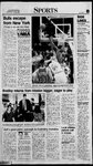
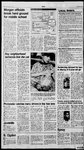
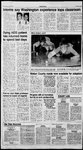
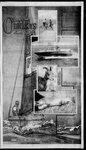
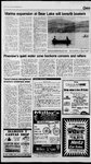
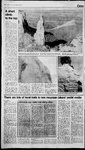
Show 12E Thursday June A short Climb to the top By ANNE RAUP tandard-Exar tat GRAND JUNCTION, Colo. — HOORAY! I've finally found a climb whereit really IS an asset to be small, and not to havea gorilla-like reach or thesort ofslight 6-4 build that enables somepeople to go up climbs in four moves that take me 20 I'd heard about mythical rock climbs where being short was actually to one’s benefit, but I had never experienced one. It was terrific — it made upfor all the times in my life I’ve gotten has- sled for being short This small-person climbing happens naturally in the desert. The Wingate sandstone that forms many of the recognizable forms in the Utah and Colorado deserts erodes in a way that creates small body-width cracks that are just right for a 5-3 person. This 5-foot-3 person and two6ee foot-and-over climbers recently scaled a route on Independence Towerin Colorado National Monument. The monument, part of the National Parks system, is located just outside of Grand Junction, Colo., — about 2'2 hours east of Green River, Utah. A spectacular drive follows the rimrock of a geologic uplift that formed the wonderful landscape. In some of the canyons towers have been carved out of the sandstone — someof them appear to be ready to fall over and continue eroding from a horizontal posi- i: * ANNE RAUP/Standard-Examiner Independence Tower rises 550 feet above the floor of Wedding Valley in Colorado National Monument and overlooks the towns of Fruita and Grand Junc- tion. The tower, located about 212 hours east of Green River, Utah, was first climbed in 1911 by John Otto, who helped establish the monument. ay tion. The tower we climbed is an impressive one standing about 550 feet above the valley floor. It was a six pitch climb, which means each climber starts and stops six times at a belay stance. This tower has an interesting history from a climber’s standpoint. It was first climbed in 1911 by a Colorado National Monument enthusiast — John Otto. Otto was a strong advocate ofthe park, helped get it established, worked as a custodian, and made manymiles of trails. On Flag Day (June 14) in 1911, Otto madethefirst climb up Independence Monument andplanted a United States flag on top. To get to the top, Otto drilled holes, into which he stuck pipes that he could stand on. He also carved footsteps, much like the Anasazi did. (As long as I brought up height, Otto must have been a pretty tall man because someof those footholds were mighty far apart.) Today’s route follows Otto’s, and still uses the carved-out steps. The pipes are long-gone, but on a couple of faces, the moves would be baffling if it weren’t for the pipe holes. The top of the climb was definitely the hardest part, mostly just for the mind — notthe body. The Pat Palmieri leads thefifth pitch of the six-pitch climb to the top of Independence Tower. heaven, it would be REALLY After a few minutes relaxing in tough. the sun on top, it’s time to do a very important part of the climb Once on top, the world seems to be at your feet. The view is great up and down the valley. You are on the same level as the tourists who are looking across the valley the climb. A stuck rope can be a — get down. In this case that really crummy wayto end an oth- means three rappels. Rappelling can be nervy, because it’s the only time that a erwise great day. over a formation shapedlikea little mushroom cap that tops the tower. If it weren’t for Otto’s foot- at you from an overlook point on the rim. You can look right into the towns of Fruita and Grand Junction. The stunning geology of doesn’t matter how shortor tall you are when you rappel. It’s the holds, that appear like steps to the monument is all around you. same for everyone. climber has to manuever up and It’s a relief when everyone and the ropes are all at the bottom of climber is totally dependent on the equipment (excepting fall). It In our case, things went fairly smoothly, a little snag in getting the ropes down but everyone had their tight smelly climbing shoes off in good time and got ready for the hike back to the car. Mark Wedekind belays Pat Palmieri on the final pitch of independence Towerin Colorado National Monument. There are lots of localtrails to test mountain bikers’ pedal mettle By JIM WRIGHT Standard-Examiner staff OGDEN — It maynot be a mountain biking hotspot, but there’s plenty of good earth to roll a pair of fat tires over in Northern Utah. The Skyline Trail from Pineview Reservoir to Lewis Peak was recently named one ofthe 10 best mountain bike rides in America by a leading mountain bike magazine, and the section between North Ogden Divide and Ben Lomond Peak could just as easily have taken that honor. “We've had people who'vetrav- eled all over the United States, bicycle sales reps, who say we're spoiled here,” said Steve Spencer, a salesman at Bingham Cycleryin Ogden. “They saythis is their favorite area to ride. After they’re done with their business, they'll run up on and do the Skyline trail or Ben Lomond.” At least as popular as the big trails are the short, hilly routes that are found across Ogden’s east bench or along the foothills of Ben Lomond. It’s not actually a trail, but one of the most heavily used mountain bike areas is at the trailhead to the Indian Trail, located just above 22nd St. A series of short trails rolls over hills and curves, creating a play area that’s attracting a lot of attention from acrobatic bikers, Similar areas exist below Strong’s Canyon and Waterfall Canyon. Although short stretches of trail are available to cyclists, the Forest Service officially discourages bicyclists from using the canyon trails above Ogden’s East Bench, said Rick Vallejos, Ogden Ranger District recreation ranger. Vallejos said the steep, narrow routes on the Indian Trail, Hidden Valley, and Taylor, Waterfall, Strong's and 4 Motorists canmaketrail biking dicey along with your Walkman on between Ogden Canyon and Wehigh. eee ber Canyon following the old _ Other potential biking areas laketerraces, will be a multi-pur- | By JIM WRIGHT Standarcd-Examiner staff Much of the attraction of riding a mountain bike is that it’s such an informal sport. Biketrails are nice. But a shortage of formal trails doesn’t mean a shortage of placesto ride. where you'll likely be sharing the - posetrail open to bikes, hikers: road with vehicles include the miles of dirt roads wind through every conceivable kind ofterrain. Northern Utah is no exception. The networks of logging roads in areas like those in the North Slope of the Uinta Mountains can provide excellent biking, but most of these roads are frequently used by motorized vehicles, . and Rich County; and the Ant Flats Road between Hardware ‘tions, cycling is not allowed on wilderness areas on the Wellsville these roads often see heavy use, Mountains and Mount Naomiin especially during hunting season Northern Utah, nor on the Twin ndsummer weekends, es Peaks, Mount Olympus and Some of the best places to ride ‘Lone Peak wilderness areas in The roads are usually on thenar 6.2487 exist only on paper. ’ the Salt Lake area. There aren't any formal moun- must b complished with a great deal care and precaution. Although a mountain bike is designed to travel over dirt roads, it won't take well to acollision with a four-wheel drive pickup. For example, sometimes your bo warning of an oncoming ver icle will be the noise of its en- | gine, Because you may need to _— scrambleoff the road in a hurry, it i8 Not good self-defense to bike mountain wilderness artain biking trails in Weber, Mor- easOther include Mount Timpanogos, gan, Davis or Box Elder counties, although several have been pro- Mount Nebo and the Deseret Peak area in the Stansbury posed. ‘ Mountains. Biking is allowedin The Bureau of Land Manage- “much of the Uinta Mountains, ment has proposed a 13-mile. but about 460,000 acres in the bike trail between the Golden | core of the range is protected as ike Naiional Historic Site anc ilder Boundaries are well- isas x silea cat marked, inking Spr m ‘Thattrail isstillin ie » fro ne. Corit preliminary \ Of “The prope ed | nevi ; © Union dnenetingTrail,which would run Ave., Burch canyons are more suited to hikers, but that there’s room for hikers than either bikes or horses. The Indian Trail receives many visits from mountain bikers, along improvement. with heavy hiking use. Spencer said bikers generally fake precautions when they're sharing a trail with \ raed. Because of these restric- Ranch and Monte Cristo. Again, row side, andviews arefrequen’ ly restricted ecaus Backcounti purpose roads f the National Forests ee | Cache Valley; the network of , for a series oftrails on the east roads in the Monte Cristo area; shore of Antelope Island that the Left Hand Fork road between would be open to non-motorized the Blacksmith Fork Canyon and recreation, Logan Canyon’s Right Fork; the - Mountain bikes are not allowed Old Canyon and New Canyonar- in federal wilderness areas, where eas between Hardware Ranch all mechanized transportationis Across the west, thousands of timber, and horses. of | Liberty-Avon divide road be-. Finally, the Utah: Division ; ; “ - . Parks and Recreation has plans tween ‘the Ogden Valley and the “I think the biggest safety concern is when you have people coming down single track trails and they aren't concerned about running into other people downthehill,” he and maps are anal . Forest Service ee eon the southend of tion, 25th St. and Wall | said, Randy Welsh, Forest Service Og- den District Ranger, said problems can be avoidedif the various trail users are cautious in hazardous ar- eas such as steep hills and blind corners, and if everyone observes rules of right of way. Someof the best rides in the Ogden area include: wArt Nord Drive between Ogden Canyon and the Snow Basin road. The abandoned road follows Wheeler Creek, which joins the Ogden River just below Pineview Dam. The road itself washed out several years ago, and was not reopened to motorized vehicles, so it makesa nicelittle tour, especially on summer evenings. The roaditself is only about two miles long; hooking up with the Wheeler Creek trail (which leaves Art Nord Drive about 1.2 miles from Ogden Canyon) can extend the route about three more miles up to the Maples Campground in Snow Basin. wSkyline Trail. The longesttrail on the Ogden Ranger District is broken into two main sections. The southern trailhead begins from the Forest Service parking lot just above the Neck at Pineview Reservoir. It winds up into the hills and can be followed to Lewis Peak, then back to Pineview or down to the trailhead at the North Ogden Divide. The first three miles or so are difficult climbing, but the route turns back to the west. It is indistinct in places, especially when overgrown. gw Wheatgrass Canyon, located just north of Causey Reservoir next to Camp Kiesel. A good single track trail winds for about five miles along Wheatgrass Creek into the Monte Cristo foothills. The trail continues for another five miles, but is poorly maintained and sometimes indistinct, so you'll need good route-finding abilities. The route ends at Bluebell Flat on Monte Cristo, so a loop tour is possible. It’s a good idea to scout the upper end of the trail to figure out where to park. Avoid the trail dur- ing high runoff periods. mw Middle Fork, Ogden River. Offers both dirt road and single track riding, but trails terminate on private land, Nice views of the Ogden Valley, and a small, scenic stream. The single track should be avoided when it’s wet, or during periods of high runoff. the mountain to Mantua. One of the most popular multiple use trails in Northern Utah. wGreen Pond, located by follow- Monte Cristo offers several one way or loop rides. The Wasatch Ridge-Baldy Ridge loop is a moderately difficult ride of about 10 miles with onesteep hill to climb. The Curtis Creek Road can be followed about 25 miles to Hardware Ranch, or made into a 63-mile loop by coming back over the dirt Ant Flats road and the paved Monte Cristo Highway, State Road 39. Several other dirt roads — Dairy Ridge and Lightning Ridge are just two — provide one way access to meadows, forests and panoramic views. road can be made into a loop by Union Pacific route. This is a 28mile, relatively flat route that fol- eases off after that. From North Ogden Divide, the Skyline Trail may be followed to Ben Lomond Peak and back, or down to North Fork Park or even on to Willard Peak and back down ‘ing the dirt road just before the upper parking lot at Snowbasin Ski Area. A nice tour along an easy dirt following a single track that forks off the road after about 3/4 of a ‘mile. The trail continues around the pond to the northeast, then w Park City to Echo over the old lows Silver Creck between lanes of Interstate 80 between Park City and its confluence with the Weber River. |