| OCR Text |
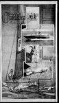
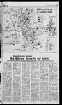
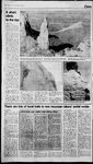
Show Standard-Examiner Thursday. June 3, 1993 SE @wuwibndDe Indian ‘Trail a thumph of local volunteerism Trail taking By JIM WRIGHT Standard-Examuner shape sta ‘Four nationaltrails A local triumph of volunteerism — the Indian Trail — will be dedicated Saturday as Northern Utah's converge at Big Mountain.’ part in National Trails Day Bench popular for N. Utah hikers Division of Parks and Recreation, Ogden City and Weber Co unty will By JIM WRIGHT hold opening ceremonies at both of Standard-Examiner staff the trail’s parking areas and trailheads. Park Service, Forest Service, Utah OGDEN — It’s a thin smile, an ironic smile, crossing Jay Hudinto the hills above Ogden. “Six years ago, that trailhead was nothing but emptycity land,” Hudson said. “Thetrail wasilldefined, overgrown, and the lower section was rutted out by vehicle traffic. It was seldom traveled by walkers.” Hudson stood at the top of 22nd Street in a parking lotthat’s becoming one of the busiest places in Ogden. If you’ve been there on a Saturday afternoon, you’d never believe Hudson was talking about the Indian Trail. The Indian Trail stretches for five miles between the east bench and Ogden Canyon. A lively, rolling trail that provides panoramas of the Great Salt Lake and glimpses into the timbered slopes above Ogden Canyon, it is used now by thousands of hikers and bikers each year. As Hudson notes,six years ago the trail was a faint scratch in the earth. The trailhead was a mass of criss-crossing ruts cut into the ground by dirt bikes. The easiest way to find the trail was to turn right at an old sofa someone had burned downto the springs and dumped onthehillside. But thanks to an industrious group ofvolunteers, the trail was rescued, and recreation in Northern Utah is the better forit. The Ogden Trails Network (formerly called the East Bench Trails Committee) is counting on duplicating that success as it proceeds with an ambitious project to establish a system that links the existing canyon trails with a proposed north to south trail on the east bench. The key to the system will be the Bonneville Shoreline Trail, a route that will run along Ogden’s and Pony Express trail, followed S.R. 65 from Henefer to Big Mountain Pass. Signs have been erected along the route marking the three trails and a number ofhistoric sites. “Four national trails converge at Big Mountain,” said John Knudson, trails coordinator for the Utah Division of Parks and Recreation “Three National Historic Trails — Mormon Pioneer, Pony Express ‘and California meet the Great Western Trail.” The Indian Trail winds for five miles above the south rim of Ogden Canyon. It offers views ofthe canyon and across the Great Salt Lake. Built almost entirely by volunteers overthe last five years, the trail is now used by thousands of hikers each year. The trail follows a route Native —— ANNE RAUP/Standard-Examiner Hundredsof hikers visit Waterfall Canyon each east benchthat will eventually be hooked into year, one of several canyon trails on Ogden’s_ a single trail system. east bench. Parts of the trail exist now, but the bulk ofit has yet to be built. The Bonneville Shoreline Trail will follow the contour of the ancient shoreline of Lake Bonneville, which receded some 10,000 years ago at the end ofthe last Ice Age. In Weber County, the trail would run from the Ogden River to the Weber River. Randy Welsh, Forest Service Ogden District Ranger, said the Bonneville trail is high on his list of priorities. A route for the trail has been roughed out using aerial photographs and some on-theground surveys. Despite the enthusiasm of volunteers and the Forest Service for the trail, it’s still several years away from being built. “The biggest impediment is our need to purchase land or easements,” Welsh said. The Forest Service has been working to obtain parcels of land along the trail route, currently concentrating on 117 acres in the Taylor Cove area at the mouth of Taylor Canyon. The Trust For Public Land, a private conserva- tion group, will actually buy the land and hold it for the Forest Service until Congress appropriates money, Welsh said. Welsh said there are eight main parcels of private land on the east bench. He said the landowners have expressed willingnessto either sell the land or an easement across ‘it for the trail. The Forest Service won’t begin trail work on land it doesn’t own, Welsh said. That means the Bonneville Shoreline Trail will be constructed in sections. The Taylor Cove area was tar- geted for the first purchase because it can be tied in easily with the Indian Trail to the north. At the Indian Trail trailhead, a short section of trail that now heads to the south before ending abruptly would be linked with the Taylor Cove route. _ Equally important, the trail would tie into the existing routes that wind into the canyons on the east bench — Indian Trail, Hidden Valley, Taylor Canyon, Waterfall Canyon, Strong’s Canyon, The trail marker will be set in place by Rep. James Hansen, R- Americans used to ascend Ogden Beus Canyon and Burch Canyon. Hudson said the Bonneville Shoreline Trail will attract visitors from across the United States, especially if one element of it is built. “In my vision of the future, we would see a 300-foot suspension bridge across Strong’s Canyon,” Hudsonsaid. Hudsonsaid the route for the Bonneville trail will climb above the mouth of Strong’s Canyon, which is located near the top of 36th St. Rather than drop the main trail back down to the canyon, he said members ofthetrail committee have been looking into bridgingit. Hudson said the popularity of the east bench trails, and the wealth of volunteer help from individuals and corporations, means a first class trail system is not just a possibility, but an inevitability. Success hasn’t changed one thing, however. “Our original purpose wastoallow people a place to walk,” Hudson said. “That’s still our purpose.” Utah, and state senator LeRay McAllister. Hansen is sponsoring legislation in the Congress to have the Great Western Trail declared a Canyon when the Ogden River was in flood. It passes high above the nver, and drops back into Ogden Canyon by wayof Coldwater Canyon. In the 1930s, Coldwater Canyon wasthe site of a Civilian Conservation Corps camp, where workers lived while building a rock wall that lined Ogden Canyon until the early 1980s. The old campsites are National Scenic Trail. The Mormon Trail separates from the other historic routes just below Big Mountain Pass, dropping slightly to the west and down Emigration Canyon. The Donner-Reed and PonyExpress trails continued down the route of S.R. 65 to Par- still apparent, as is the remains of a kiln used to smeit limestone at the mouth of Coldwater Canyon. Indian Trail was built largely through the efforts of volunteers, eventually leading to the creation of the East Bench Trails Committee, which coordinated volunteer efforts with state and federal agencies. Nowcalled the Ogden Trails Network, the volunteer group is planning an ambitious trail system along Ogden’s East Bench that links a series of canyon trails with the proposed Bonneville Shoreline Trail. Another event Saturday will be a ley’s Canyon. The dedication will be held at 10 a.m. Saturday. Afterward, Knudson will lead a 4.2 mile hike from Big Mountain Pass to Mormon Flat Big Mountain Pass is located about 62 miles south of East Canyon Reservoir on S.R. 65. The trail begins at the pass and heads east, downhill, to Mormon Fiat. “We'll hike backwards in time,” Knudson said. “The pioneers camped at Mormon Flat, then came out at Big Mountain. We'll be doing the reverse on Saturday, but it’s an easier hike for folks who don’t want to walk uphill.” For information about other Na- ceremony to set a marker at Big tional Trails Dayactivities, call the parks division, 538-7200. Mountain Pass, south of East Can‘yon Reservoir on State Road 65, at Bench s East n ils’ alongde ppyOTrag ~. Waterfall Canyontrail . Burch Creek trail Access: Top of 29th Street ~ : — ei i 5; ‘ t Burch |Creektrail — 50) Oo... a Length: 1.25 miles Season: Middlespringto fall sew feet; ending, 6,800 feet sy < Length: 2 miles Season: Summertofall ; i - 6 = © Ss $ = i Use: Light, (hiking, horses) : Difficulty: Moderate Pil Waterfall o “a3 4 ' ‘ 1 2 Canyon = Malans Peak @ . Waterfall trail : -132ndSt. EES : Be ConMay % Mount Ll j 2 Ogden Park | 6th Ss Strongs Cane Distance in miles Ogde ~ N 2 i 1 ef Distancein miles ono oo S 8 1 s Trail distance and elevation # 8 Dry Canyon Trail distance and elevation Access: South of Knollwood #7 condominiums 4 : & _ Golf Difficulty: Moderate Wagaieh-Cache [gsal Elevation: Beginning, 5,200 Ogden — Use: Heavy, (hiking) |. Neomirces oe4 lens] Elevation: Beginning, 5,000 testening5200 ee Ogden hikingtrails 2 one ‘“ the junction of three National Histonic trails The old Mormon Pioneer Trail, as well as the Donner-Reed trail fire hazard sign, will be dedicated at 9 a.m. Participants will then hike over the trail, where a second ceremony will be held at the 22nd St. trailhead at 12:30 p.m. ‘Ha «4 trails coordinator The Ogden Canyon trailhead, located about a mile above Rainbow Gardens at the Smokey the Bear son’s bearded face as he stares up “ — John Knudson Representatives of the National City Source: Wasatch-Cache National Forest, Ogden Ranger District n Beus Canyon trail The Indiantrail Malans Private J lands z Basin Forest Service Mount Ogdene Ylor Canyon Tal gtrongs Canyon Z Strongs Peak @ oes ‘Beus Canyon trail + Wasatch-Cache National Forest ~ i { Access: Top of 22nd. St; also _—‘Trail distance and elevation Smokeythe Bearsign 1.2 miles " Access: Eastfrom 4600 S. Elevation: Beginning, 4,750 8 feet; ending, 9,200 feet feet; ending, 4,650 feet e 57 Length:5 miles Season: Spring to fall , oe TS Ei ii a Use: Heavy, (hiking) 3 Cr aeie owe ed Difficulty: Difficult up Ogden Canyon. ; Difficulty: Moderate | Source: East Bench Trails Committee 6 iene 1 2 3 Distance in mites ea 4 5 Pare li : street at microwavestation iu Elevation: Beginning, 5,100 g 9 Length: 3.6 miles ¢ | Season: Summer to fall ov] Use:Light, (hiking) ee Source: East Bench Trails Committee, |TN___ Masate-Cacho Nationa Forest = . Trail distance and elevation Ogden Ranger District hy! 5 “ Lg ; § 7 zal Pe w § ee 1 2 ae 41} 3 4 rae Standard-Examiner |