| OCR Text |
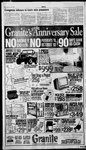
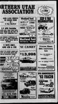
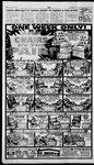
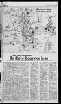
Show Standard-Examiner Thursday, June 3 1993 3E @uinoe aN Raft River Mountains N , National ( Site ’ \ \ | a \ Great Salt Lake > \ \ 4fX_ Bird Refuge Logan Willard (|) Ogden 5 yy’ \ Av1 forests Pineview Reservoir Snowbasin Utah Test & a Lost Creek ’ : h{ mn aa Reservoir ; High Uintas| Salt Lake f Cave | % (restricted) 5 Vernal = Express Ee ie al' | i Strawberry Reservoir Green River < Mt. Nebo Wilderness Scofield Reservoir Nine Mile Canyon 8) | Key to colors ZAP Kes ne omnes Monument & a _ 3 ms . o WO | 3 : Dinosaur National Deer Creek Reservoir & Provo River_.. iS cme ad rror Lake Highway Timpanogos ~ a% Utah Test & Training Range — Wilderness = | Areas E =e— : : — Canyons" = Deseret Peak] «= ee lerness Area Cottonwood | .- i City ities. Di ‘esis ae River IYoy alt Lake J i aminer Area Rockport ; ee (80) | Echo Reservoir G) Farmington, oe To Wendover aig Recreational Wyoming ‘ | Bay SETS ie - or| Evanston Reservoir Y Range Training (restricted) Scenic J Antelo, island es 5; | G0 Monte Cristo X15) Eee | | bis Shon ee) gh | Ly: FS(ss) EN Bay Utah ern ane Hardware Ranch Reservoir “_ or fyrum Blacksmith : \ n Northern ¥ Park ” Mantua > i we ‘onan —. /\ K Migratory, 0 \ Salt one — FA Historic Lake ra en (is) § Spike 2 ‘ \3 Great Mountains Where you can go ES A |e 5 Wellsville Locomotive Golden Springs 4 Utah e == P Sel \= cm %J O National Forest Service lands a | National Monument/ Recreational lands a Wilderness areas a 4} | : Governmentareas (restricted) Reservoirs and lakes = (no vehicles) Standard-Examiner | Knee deep into summer In three hours or less ite Ny Logan Canyon is one of the most visited mountain canyons in the state, and for good reason. Thousands ofanglers travel along the route to fish the Logan River, home to cutthroat and browntrout. There are hiking and biking areas, and limestone cliffs noted by rock climbers. Twenty Forest Service campgroundsare located along the river banks or witnin a short drive of the road. The canyon provides access to Bear Lake and Tony Grove Lake. Managed by the Logan Ranger District (753-2772). Bear Lakeis one of Utah’s most stunning natural wonders. Clear, deep and startlingly blue, the lake is 21 miles long, seven miles wide. Half of the lake is in Utah, halfin Idaho, and both states have state parks on the lake. Utah state park facilities (946-3343) include the marina near Garden City, Rendezvous Beach on the south shore, and Cisco Beach on the east shore. Boating is superb, but launching larger boats won’t be an easy task until the marina is renovated. The lake is nearly 6,000 feet high, so the best time to swim is in midsummer. Good fishing for cutthroat, lake trout and whitefish. Hyrum State Park is located on 3,000-acre Hyrum Reservoir. Facilities include campground, showers and boat ramp. Thelake offers fair fishing for trout, bass and perch. Call Hyrum State Park (245-6866). Blacksmith Fork is one of the ers premiertrout fisheries in Northern Utah. The stream is fed by springs, and usually maintains a consistent, clear water level. The surrounding canyon is noted for high, sheer cliffs and abundant wildlife. Hyrum City maintains a small park, andthe Forest Service has a pair of small campgrounds along the banks of the river. There is a great deal of private land, but most of the river is open to fishing. A tributary, the Left Hand Fork, also has a pair of campgrounds and access to a number of hiking trails. Managed by the Logan Ranger District (7532772). Hardware Ranch is a wildlife management area located at the head of Blacksmith Fork Canyon The ranch is used as a winter feeding station for hundreds ofelk Sleigh rides among the herd are a popular tradition. The ranchis also ‘ an unofficial’ headquarters for Northern Utah snowmobilers. There are no summer activities, but the roads winding through the ranch provide access to a number of high country areas. Call the Utah Division of Wildlife Resources (479-5143). Mount Naomiis one of two federal wilderness areas in Northern Utah. Vehicle use is barred, and primitive camping only is permitted. The best vehicle access to the area is from the west, by way of Smithfield Canyon. Hiking trails lead to the wilderness area from Logan Canyon, the Cottonwood Canyon and Tony Grove Lake trailheads the most popular. Call the Logan Ranger District (7532772). Wellsville Mountains comprise Northern Utah’s other wilderness area. Extremely rugged, the Wellsvilles are much less visited, although in late summer hundreds of hikers are attracted to the peaks to watch the annual concentration of birds of prey. Hawks by the hundreds use the loft of warm thermal currents to rise thousands offeet above the valleys below. They use the elevation gain to continue their southern migrations. Call the Logan Ranger District (753-2772). Pineview Reservoir is the most heavily used recreational area in Weber County. The lake offers boating, swimming, fishing and camping. There are boat rampsat Port Ramp and Cemetery Point, and campgrounds at Anderson Cove and Jefferson Hunt. Access to the Skyline Trail can be obtained at a trailhead just above the Neck area on State Road 162. The upper North Armofthe lake is open only to motorless boats, Call the Ogden Ranger District (625-5112), Snow Basin offers some ofthe best hiking and sight-seeing in Northern Utah, as well as limited camping in the Forest Service Maples campground, Good hiking in the Maples area, as well as Green Pond and Wheeler Creek, Call the Ogden Ranger District (625-5112) Monte Cristo is a large area criss-crossed by roads, primitive hiking trails, good horseback riding and occasionally, good fishing on small streams. Call the Ogden Ranger District (625-5112), Golden Spike National Historic Site on Promontory Summit is where the Transcontinental Railroad was completed 124 years ago. Included on the site are historical displays, duplicates of the original steam engines, and more. There are also hiking, biking and driving tours. Call Golden Spike, 471-2209. Antelope Island is preparing to open to the general public again on July 1. Facilities include beaches, showers, food concessions and hiking, biking trails. Call Antelope Island State Park, 451-3397. Raft River Mountains are located in the extreme northwestern corner of Box Elder County. Managed by the Sawtooth National Forest, in Burley, Idaho. There is limited campground space, and some primitive camping available, as well as some hiking opportunities. One of the most remote recreational sites in Utah. Call the Burley Ranger District, (208) 6780439. Great Salt Lake dominates north-central Utah, but there are surprisingly few areas where visitors can reach the lake. The two best are Antelope Island State Park and Great Salt Lake State Park, located on the lake’s south shore. Facilities include swim beaches, showers, picnic areas and marina. Call Great Salt Lake State Park, 533-4080. Bear River Bay is a federal waterfowl refuge located just west of Brigham City. Thousands of acres of wetlands provide food and shelter for dozens of species of birds. Limited vehicle tour available, and some hiking areas, Call the refuge headquarters at 723-5887. State waterfowl refuges include Ogden Bay, Farmington Bay, Locomotive Springs, Salt Creek and Public Shooting Grounds, Wonderful places for photography, hiking and watching wildlife. Some restrictions may be placed on access to protect nesting birds, Call the Utah Division of Wildlife Resources, 479-5143 Henefer-Echo is a big game management area located between the Weber River on the south and Echo Canyon on theeast. Vehicle access is restricted, but there is somegood, challenging hiking and nice horseback riding at times, Call the Utah Division of Wildlife Resources (479-5143) Echo Reservoir is located at the junction of Interstates 80 and 84, about 45 miles east of Ogden. It’s a decent fishery for trout and catfish, with some good boating opportunities. The boat ramp is operated by the Echo Resort, 336-9894. Rockport Reservoir is located just off I-80 at the Wanship exit. Utah State Park facilities include boat ramp, campground and. day use areas. Call Rockport State Park, 336-2241. East Canyon Reservoir is located about 10 miles east of Morgan on S.R. 66. The State Park operates boat ramp, campground and day use areas. Private businesses operate the marina store at the State Park and the East Canyon Resort at the upper end. Call East Canyon State Park, 829-6866. Lost Creek Reservoir is located about 10 miles north of Croydon, Often good fishing. Boat ramp operated by East Canyon State Park. Call 829-6866. Mirror Lake Highway is the main access to the Uinta Mountains. More than 20 Forest Service campgrounds are located along this route, and the DWR stocks most of the lakes with catchable trout regularly during the summer. Excellent hiking opportunities, some good biking on dirt roads, and plenty of wildlife. Call the Kamas Ranger District, 783-4338. North Slope of the Uintas is a semi-primitive area typically reached bydirt roads accessible by way of either Evanston or Mountain View, Wyo. It includes the Henry's Fork and Smith’s Fork, the two main accesses to Utah's highest mountain, King’s Peak. Outstanding hiking, fishing and horseback riding. Bicycling is prohibited in the wilderness area, but there’s a lot of timber and mining roads outside the wilderness. Call the Evanston Ranger District, (307) 789-3194, or Mountain View Ranger District, (307) 782-6555, Flaming Gorgeis one of Utah's premier recreational centers. Good boating, fishing, sightseeing. Camp ing on the lake andin the nearby Ashley National Forest is excellent Wildlife includes antelope, osprey elk and deer. Call the Utah Divi sion of Wildlife Resources (885 3164) or Flaming Gorge Ranger District (885-3315) ) Green River below Flaming Gorge is the best trout stream in Utah, and one of the best in the West. It’s popular as well with recreational floaters, who can rent rafts at a number of businesses in the area. Call the Utah Division of Wildlife Resources (885-3164) or Flaming Gorge Ranger District (885-3315). Brown’s Park is a state waterfowl management area located on the Green River near the UtahColorado border. It’s the site of an old Butch Cassidy hangout. Call the Utah Division of Wildlife Resources, 789-3103. Dinosaur National Monumentis located in Utah and Colorado along the Green River. In addition to the famed dinosaur quarry, there is good hiking, biking and excellent white water rafting on the Green. Call Dinosaur National Monument, 789-0487. Strawberry Reservoir is the best trout lake in Utah, and the most popular. There is also good hiking around the lake and in the surrounding mountains, and good opportunities for recreational boating. Call the Uinta National Forest, 377-5780. Salt Lake wilderness areas include Lone Peak, Mount Olympus and Twin Peaks. An abundance of hiking areas, including peaks that exceed 11,000 feet. Trails visit secluded lakes, streams and magnificent cliffs hundreds of feet high. Call the Wasatch-Cache National Forest, 524-5030. Timpanogos is another federal wilderness area, and the most im- posing landmark in Utah County, The peak climbs to better than 11,000 feet, and the high meadows are famous for spectacular displays of wildflowers. Timpanogos Cave, located in American Fork Canyon, is a popular tourist attraction, Call the Uinta National Forest, 3775780. Cottonwood Canyons provide access to the heart of the Wasatch Mountains, as well as a number of resorts and Forest Service recreation areas, Litthe Cottonwood Canyon is a famed rock climbing area, with granite walls andcliffs that challenge the best climbers Call the Wasatch-Cache National Forest, 524-5030 Mt. Nebo, in Juab County, is another Forest Service wilderness ar- ea. It’s non-wilderness portion is split by the Nebo Loop, a spectacular drive through rocks, timber and streams. Call the Uinta National Forest, 377-5780. Scofield Reservoir is historically one of the best trout fisheries in Utah, although it’s recovering from a DWR project to remove nongame fish. Several nearby streams, including the Price River and Fish Creek, are excellent fisheries. There is a National Recreational Trail along Fish Creek between the lake and Jones Ridge to the east. Call the Manti-LaSal National Forest, 637-2817. Nine-Mile Canyon is a famous Native American rock art site located just south of Price. Don’t let the name fool you — the canyon runs for dozens of miles toward the Green River, over generally good dirt roads. Mostly on private land, but access is generally good. Call the BLM at 637-4584. Daniels Canyon is the main route between Heber City and the Strawberry Valley. It’s a popular recreation area, with a few Forest Service campgrounds and trails scattered through the canyon. Call the Uinta National Forest, 3775780. Utah Lake is the second largest lake in Utah. A popular boating area, especially in spring and early summer. Fishing is good at times for white bass, catfish, walleye. Call the Utah Lake State Park, 3750733, Provo River is one ofthe premier brown trout fisheries in Utah. Fishing below Deer Creek Reservoir is limited to artificial flies and lures between the dam and Olmstead diversion. Call the Utah Division of Wildlife Resources, 489-5678 Pony ExpressTrail is a federally designated historic trail, following the old Pony Express route across Utah’s west desert. Passable by most vehicles, Call the Bureau of Land Management, 977-4300, Deseret Peak is a federally-designated wilderness area in the Stansbury Mountains just south of the Great Salt Lake in Tooele County, It’s an island ofsorts, with alpine terrain and conditions in the middle of one of the most inhospitable areas on the earth. Call the Wasatch-Cache National Forest §24-5030 |