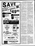
| OCR Text |
Show THE SAN JUAN RECORD Wednesday March 2,198S Page 20 Public notice Public notice Notice of trustee's sale The San Juan County Human Services Board will be meeting Tuesday, March 8, 1988, at 2:00 p.m. at the San Juan Social Services Building, 522 North 100 East, Blanding, to hear proposals for the Social Services Block Grant discretionary funding for this coming fiscal year. In order to be eligible for this funding, a program must meet one or more of the BLUFF WATER AND SEWER USERS ASSOCIATION NOTICE OF ANNUAL following goals: Utah. Tentative Agenda: 1. Annual Report. 2. Election of Board of Directors as follows: 1 vacancy of 2 year term. 3. Transaction of any other business as may come before the meeting. 4. Discussion of increase in rates and enforcement of payment of those rates. Published in The San Juan Record February 24 and March 2, 1988. The following described real property will be sold at public auction to the highest bidder, payable in lawful money of the United States at the time of sale, at the West entrance of the San Juan County Courthouse, 117 South Main Street, Monticello, San Juan County, Utah, on Wednesday, March 30, 1988, at 2:00 p.m., for the purpose of foreclosing a trust deed and corrections and amendments thereto all of which were executed by DeMar B. Perkins and Helen M. Achieving or maintaining economic to prevent, reduce, or eliminate dependency. 2. Achieving or maintaining including reduction or prevention of dependency. 3. Preventing or remedying neglect, abuse, or exploitation of children and adults to protect their own interests, or preserving, rehabilitating, or reuniting families. 4. Preventing or reducing inappropriate institutional care by providing for community-baseor care, home-baseother forms of less intensive care. 5. Securing referral or admission for institutional care when other forms of care are not appropriate, or providing services to individuals in institutions. If you have questions regarding this funding, you may contact Jed Lyman, Chairman of the Human Services Board, of Glenna Webb, San Juan Human Services Planner, Published in The San Juan Record February 24 and March 2, 1988. 1. self-suppo- rt d d 678-229- 1, 678-321- Notice to water users The following application(s) have been throughout the entire year unless otherwise designated. Locations in SLB&M. State of State Lands & Forestry, P.O.Box 32, Moab. UT. SOURCE: QUANTITY: 19.5 ac-fUnnamed Stream. Intermittent 05-222- 1 MEETING. To all members of Bluff Water and Sewer Users Association: As provided in the articles of incorporation, the yearly membership meeting will be held at 7:00 P.M. on Wednesday, March 16, 1988 at the Bluff Elementary School in Bluff, (A63025) APPLICANT: of Utah Division t. POINT(S) OF DIVERSION: (1) N 170 W 125 from S'A Cor, Sec 18, T27S, R23E. (10.5 mi SE of Moab) STORAGE: (1) In non-revolvi- (538-7240- 2 Unnamed reservoir 1, Capacity 12.0 height of dam 6 ft., inundating 2.00 acs. in SE'ASWA Sec 18, T27S, R23E. (2) In Unnamed Reservoir 2, Capacity 7.5 height ofdam 6 ft., inundating 1.25 acs. in SEViSW Sec 18, T27S, R23E. USE: Stockwatering: 500 head of ac-ft- ., ac-ft- ., livestock. PLACE OF USE: SE'ASWA Sec 18, T27S, R23E. Protests resisting the granting of these applications with reasons therefore must be filed in duplicate with the State Engineer, 1636 West North Temple, Salt Lake City, Utah 84116 on or before APRIL 2, 1988. Robert L. Morgan, P.E. STATE ENGINEER Published in The San Juan Record February 17, 24 and March 2, 1988. Invitation to bid San Juan County and San Juan County Hospital are requesting bids to install a cafeteria plan (125) for its employees. The plan should entail tying in existing after-tapayroll deductions for life and accident insurance and insurance coverprovisions for pre-tax 3 r, 09-155- 8 t. XA T42S, R19E. (Mexican Hat) USE: Other: Uranium Tailings Cleanup. PLACE OF USE: SE14 Sec 13; Sl2 Sec 15, T42S; SW14 Sec 1; Sl2 Sec 2; NEl4 Sec 10; NW14 Sec 11, T43S, R18E. APPLICANT: (A63055) Western Gas Processors, P.O. Box 310, Blanding. UT. QUANTITY: 0.015 cfs. SOURCE: 8 in. well 300 ft. to 500 ft. deep. POINT(S) OF DIVERSION: (1) S 820 W 1519 from El4 Cor, Sec 19, T38S, R24E. (8 mi. east of White Mesa) USE: Domestic: 5 persons; Industrial; Gas Plant. PLACE OF USE: N12SE14 Sec 19, T38S, R24E. Robert L. Morgan, P.E. STATE ENGINEER Published in The San Juan Record February 17, 24 and March 2, 1988. 09-155- 9 Public notice Probate, Guardianship, Trust and Conservator Notices. Consult clerk of the court or the respective signers for further information. x age. Copies of the bid letter are available at the Clerks Office at the San Juan County Courthouse in Monticello. The deadline for proposals is March 15, 1988, and should be sent to San Juan County Clerk, P.O. Box 338, Monticello, UT S4535. DATED this 23rd day of February, 1988. s Gail D. Johnson San Juan Co. Clerk Auditor Published in The San Juan Record March 2, 1988. ANNOUNCEMENT OF APPOINTMENT OF PERSONAL REPRESENTATIVES AND NOTICE TO CREDITORS Estate of Anna Catherine Kalvelage Kemner Deceased Probate No. 1254 in the District Court of San Juan County, State of Utah. Donald G. Kemner has been appointed personal representative of the above estate and all persons having claims against the above estate are required to present them to the personal representative or to the Clerk of the Court on or before the 3rd day of June, 1988, or said claims shall be forever barred. Donald G. Kemner South 156 East (93-8- ) Blanding, UT 84511 Published in The San Juan Record March 2, 9 and 16, 1988. 400 bearing is the line between the West Quarter (W lA) comer and the Northwest (NW) comer of said Section 30, being North. Together with: (VQ Parcel 1 (b): An undivided in: Begintenancy in common interest ning at a point at the fence comer which is South 19.71 feet and East 619.16 feet of the West Quarter (W XA) comer of Section 30, Township 33 South, Range 24 East, S.L.M.; and running thence East along the fence line 16.74 feet to a point which is South 19.71 feet and East 635.90 feet of the West Quarter (WV4) comer of said Section 30, thence North 5759'04" East along the fence line 29.71 feet, thence North 8959'52" East along the fence line 254.33 feet to the fence comer which is South 3.95 feet and East 915.42 feet of the W est Quarter QNlA) comer of said Section 30, thence South 8933'28" East along the fence line 139.91 feet to the fence comer, thence leaving the fence line and running South 51.09 feet, thence North 8946'53" West 35.03 to the fence comer, thence North 8946'53" West along the fence line 382.78 feet to the fence comer which is South 54.53 feet and East 637.52 feet of the West Quarter (W XA) comer of said Section 30, thence leaving the fence line and running North 8946'53" West 18.36 feet to the fence line, thence North 34.76 feet along the fence line to the point of beginning. Containing 0.49 acres, all located in Section 30, Township 33 South, Range 24 East, S.L.M. Basis of bearing is the line between the West Quarter (WV4) comer and the Northwest (NW) comer of said Section 30, being North. Subject to an easement for ingress and egress for the benefit of Norma P. Young to the following portion of Parcel 1 (a): Beginning on the fence line at the Northeast (NE) comer of PARCEL 1 (a) and which point of beginning is North 685.25 feet. East 946.55 feet and South 8951'31" East 758.21 feet of the West Quarter (W XA) comer of Section 30, Township 33 South, Range 24 East, S.L.M.; and running thence South 254'06" West 689.68 feet along the fence line and the East line of PARCEL 1 (a) to the fence corner and the Southeast (SE) comer of PARCEL 1 (a), thence South 8957'44" West along the fence line and one-ha- lf Perkins, as Trustors, in favor of First Security Bank of Utah, N.A., covering various parcels of real property located in andor near Monticello, San Juan County, Utah. DeMar B. Perkins and Helen M. Perkins, as Trustors, on December 21, 1984, delivered to Southeastern Utah Title Company, as Trustee, and First Notice to water users Security Bank of Utah, N.A., as Beneficiary, a Trust Deed on certain real The State Engineer received the property situated in San Juan County, following Applications to Appropriate Utah. Also on December 21, 1984 those Water in San Juan County. (Locations promisparties signed a in SLB&M). Persons objecting to an Note was which note sory (Note), application must file a Protest stating secured by the Trust Deed. The Note has the reasons for protest. To have a been extended and modified, the last hearing before the State Engineer, such modification having been signed on persons must request a hearing in the or about August 11, 1987. On or about Protest File Protest in duplicate with August 12, 1987 an assignment (AsState Engineer, 1636 West North signment) of the Note, as modified and Temple, Salt Lake City, Utah 84116, extended, and of the Trust Deed, as on or before March 23, 1988. ) corrected and amended, was recorded. These are informal proceedings as per Pursuant to that Assignment First Rule R625-6-of the Division of Water Security Bank of Utah, N. A. assigned its Rights. beneficial interests in the Note and Trust (A63049) APPLICANT: Deed to First Security Mortgage Spanish Valley Energy Company, 505 Company. On or about that same day a UT. Moab. North Main Street, Correction andor Amendment to Legal QUANTITY: 60.0 cfs. SOURCE: Mill Descriptions in Trust Deed (Correction Creek. POINT(S) OF DIVERSION: (1)N Amendment) was recorded as was a 95 W 877 from El4 Cor, Sec 5, T27S, Modification Third and Extension R23E. USE: Hydro-PowePower Plant Agreement (Third Modification). Name: Navajo 1, Rated Capacity The real property described in the 4500000 KW. PLACE OF USE: Trust Deed and in the Trust Deed, as SW14SW14 Sec 5, T27S, R23E. The corrected and amended, pursuant to the water will be returned to the natural Correction Amendment is located in stream or source at a point(s): (1) N 660 E San Juan County, Utah and is more 660 from SW Cor, Sec 5, T27S, R23E. ; particularly described as follows: (A63035) APPLICANT:M-The legal description contained in the Ferguson Co. for U.S. Dept, of Energy, original Trust Deed was: P.O. Box 9136, Albuquerque. NM. PARCEL 1: Township 33 So. Range SOURCE: San QUANTITY: 50.0 ac-f24 E, SLM Section 30; Beginning South Juan River. POINT(S) OF DIVERSION: 2640' & W 825' of N Comer Section 30, (1) S 2550 E 1650 from NW Cor, Sec 7, thence W 771', N 691', E 771' S 691' to 05-222- filed with the State Engineer to appropriate water in San Juan County J - POB. PARCEL 2: Beg at the NW cor Lot 3, Blk G, MTS and mg th W 20', th S 135', th E 20' th S 40.5' th E 104.9' th N 2.5', th E 5.5' th N 10.5' th W 5.5' th N 162.5' th W 107.5' to POB. MONTICELLO TOWN-SITE PARCEL 3; Beg S 1650' of WA Cor of Sec. 30, T33S R24E, SLM, E 619.16', S 41', W 214.5'; S 429' W 404.6', N 460' to beg. PARCEL 4: Beg at a pt N 463.3' from SE cor Sec 25; mg th W 668.5'; th N 525'; th E 668.5' th S 526.7' to pt of beg. Less: - to Richard Bailey (Bk.597 .34 acres - to Lloyd D. .34 Acres Less: P.186). Perkins et ux (Bk.631, P.364-5)- . Less: .34 - to Glenn W. Wallace et ux Acres (Bk.631, P.362). T.33S., R.23E., SLM. (Real Property) The corrected and amended legal description of that property as contained in the Correction Amendment is: PARCEL 1 (which includes both parcels 1 (a) and 1 (b) described below) Parcel 1 (a): Beginning at a point at the fence comer which is South 3.95 feet and East 915.42 feet of the West Quarter (WV4) comer of Section 30, Township 33 South, Range 24 East, S.L.M.; and running thence South 8933'28" East along the fence line 139.91 feet to a fence comer, thence South 8948'59" East along the fence line 205.88 feet to the fence comer, thence North 8957'44" East along the fence line 408.64 feet to the fence comer, thence North 254'06" East along the fence line 689.68 feet to the fence comer, thence North 8951'31" West 758.21 feet to the fence line at a point which is North 685.25 feet and East 946.55 feet of the West Quarter (WV4) comer of said Section 30, thence South 235'10" West along the fence line 689.90 feet to the point of beginning. Containing 12.0 acres, all located in Section 30, Township 33 South, Range 24 East, S.L.M. Basis of South line of PARCEL 1 (a), 408.64 feet to the fence comer, thence North 8948'59" West along the fence line and the South line of PARCEL 1 (a) 205.88 feet to the fence comer and the Northeast (NE) comer of PARCEL 1 (b), thence North 8933'28" West along the South line of PARCEL 1 (a) and along the North line of PARCEL 1 (b) 35.03 feet, thence North 254'06" East 20 feet, thence South 8933'28" East 35.03 feet, thence South 8948'59" East 205.88 feet, thence North 8957'44" East 388.64 feet, thence North 254'06" East 669.68 feet, more or less, to the North line of PARCEL 1 (a), thence South 8951'31" East along the North line of PARCEL 1 (a) 20 feet, more or less, to the point of beginning. PARCEL 2: Beginning at the Northwest comer of Lot 3, Block G. MONTICELLO TOWNSITE SURVEY, and running thence West 20 feet; thence South 135 feet; thence East 20 feet; thence South 40.5 feet; thence East 107.5 feet; thence North 2.5 feet; thence East 5.5 feet; thence North 10.5 feet; thence West 5.5 feet; thence North 162.5 feet; thence West 107.5 feet to the place of beginning. PARCEL 3: Beginning at a point 1650 feet South of the West Quarter 'A) comer of Section 30, Township 33 South, Range 24 East, Salt Lake Base and Meridian, and running thence East 619.1 feet; thence South 41 feet; thence West 214.5 feet; thence South 419 feet; thence West 404.6 feet; thence North 460 feet to the place of beginning. PARCEL 4: Beginning at a point on the East line of Section 25, Township 33 South, Range 23 East, SLM, which is North 463.3 feet of the Southeast comer of said Section 25, and running thence North 526.7 feet along the East line of said Section 25 to the Southeast comer of the tract of land conveyed to K.S. Summers Livestock, Inc., in the Deed which was recorded in the Office of the San Juan County Recorder in Book 507 at Page 98 of official records of San Juan County; thence West 146.5 feet along the South line of said tract of land conveyed to K. S. Summers Livestock, Inc., to the Northeast comer of the tract of land conveyed to . W. Richard Ellison and Kristine P. Ellison in the Deed which was recorded in the Office of the San Juan County Recorder in Book 672 at Page 459 of official records of San Juan County; thence South 200 feet to the Southeast comer of said tract of land conveyed to W. Richard Ellison and Kristine P. Ellison; thence West 522 feet along the South line of said tract of land conveyed to W. Richard Ellison and Kristine P. Ellison to the East line of the tract of land conveyed to Norma P. Young in the Deed which was recorded in the Office of the San Juan County Recorder in Book 581 at Page 536 of official records of San Juan County; thence South 326.7 feet, more or less, to the Southwest comer of the tract of land conveyed to DeMar B. Perkins and Helen L. Perkins in the Deed recorded in the Office of the San Juan County Recorder in Book 579 at Page 805 of official records of San Juan County; thence South 8911' East 668.5 feet, more or less, along the South line of said tract of land conveyed to DeMar B. Perkins and Helen L. Perkins to the point of beginning, LESS the following described portions thereof: (a) Beginning at a point 439.62 feet North and 365.21 feet West of the Southeast comer of Section 25, Township 33 South, Range 23 East, Salt Lake Base and Meridian, and running thence North 8828' West 150.0 feet; thence North 050' East 100.0 feet; thence South 8828' East 150.0 feet; thence South 050' West 100.0 feet to the point of beginning. (b) Beginning at a point 439.62 feet North and 165.21 feet West of the Southeast comer of Section 25, Township 33 South, Range 23 East, Salt Lake Base and Meridian, and running thence North 8828' West 150 feet; thence North 050' East 100 feet; thence South 8828' East 150 feet; thence South 050' West 100 feet to the point of beginning. (c) Beginning at a point 539.62 feet North and 165.21 feet West of the Southeast comer of Section 25, Township 33 South, Range 23 East, Salt Lake Base and Meridian, and running thence North 8828' West 150 feet; thence North 050' East 100 feet; thence South 8828' East 150 feet; thence South 050' West 100 feet to the point of beginning. The Trust Deed was recorded on December 28, 1984, as Entry No. IH 08063 in Book 665 at Page 703 et seq. of the official records of the San Juan County Recorder. The Assignment was recorded on August 12, 1987, in Book 689, page 7 et seq., the CorrectionAmendment was recorded on August 12, 1987 in Book 689 page 13 et seq. and the Third Modification was recorded on August 12, 1987 in Book 689 page 21 et sea., all in the official records of San Juan County. DATED this 22nd day of February, 1988. FIRST SECURITY BANK OF UTAH, N.A., Trustee s James L. Widle Ray, Quinney & Nebeker, Attorneys Published in The San Juan Record March 2, 9 and 16, 1988. Public notice A public hearing will be held on March 9, 1988 at 7:30 P.M. at the Blanding City Council Chambers. Blanding City Council requests its citizens to give ideas and information for possible projects which could be funded by an Interim Loan through the Community Development Block Grant Program. The City will then use this information in formulating an application. s Norman L. Johnson Recorder Published in The San Juan Record March 2, 1988. More public notices on page 18. |