| OCR Text |
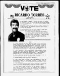
Show fence line(which THE SAN JUAN RECORD Wednesday September 24, 1086 - Page 15 is also the to E a 12" rebar which is N 30Old Grand County Airport Road, th SLM) line of Lot 4, N 8911' w 26.1'to cedar a th N 453.1' with a fence on the E of the Flinn tract to a fence corner, thence withboundary a fence at the Flinn North Boundary N8907' w th North 009' E 628.5' to the point of beginning. 625.0', 9.74 ac, m.o.l. Containing are based on the North line, Section 1, T27S, Bearings R22E, SLM post, is T27S, R22E, of the center line of the - 61 Beg at a pt on the N line of Sec 1, T27S, R22E, SLM, which bears East 675.6' from the NW cor Sec 1 T27S SLM R22E said pt of beg being a 12" rebar; and running th S 558.0 ft to a corner, th 234. 2 'to a corner, E th N 460.3' to a corner, th N 5138' E 157.2 to a pt on 003' N the line of Sec 1, T27S, R22E, SLM, th E 111.0' along the N line of Sec 1, T27S, R22, SLM, to p.o.b. Cont. 2.86 ac, m.o.l. 3' W W 25 at a on the W line of Sec 1, T27S, R22E.SLM, which 303.1' from the NW cor Sec 1.T27S, R22E, SLM; and running th N 5930' E 172' to a corner, th N 8151' E 177.9' to a corner, th N 5138' E 149.3' to a corner which is E 441.4' and S 003 W 97.7' of the NW cor Sec 1, T27S, R22E, SLM, th S 003 W 460.3' to a corner, th 440.6' to a pt on the W line of Sec 1, T27S, R22E, SLM, th N 254.9' line of Sec 1, T27S, R22E, SLM to pt of beg, along the cont. 3.56 acres m.o.l. Beg bears pt 002' S E Sec 35, 03' W 8958' T26S R22E , , , Beg N 89 154.4' 59' 283.3' to POB. N W E 518.2' & 280.5', W 2682 N 0 of 58' cor E4 S 154.5', W Park visitors 0 S Less: .83 acres. 42 (East). 24 with a rebar with cap attached. monumented Sec 35, T26S W E 282.5', 305', W 78' to POB. at of E4 cor, 518.2' N & 2682' 328', S 315.6', E 328', S 23'58' R22E Beg , N W N E 485', 518', center 14 section 1 T27S, R22E, SLB&M and S 0 04' E 990.0', th S 89 58' W 660.0', th N 0 04' E 990.0; th N 89 58' E .660.0' to the POB and cont 15.0 ac, m.o.l. Each corner is monumented with a 58" rebar with aluminum cap as shown on plat. Bearings are based on the line of Sec 1 (North). This tract is subject to a 60.0' wide road easement along the entire N boundary which is situated parallel with and adjacent to the N boundary line. The Petitions of the following were filed on or about the following dates: 43 Beg the proceeding th W W Arnel H. and Myrtle Holyoak, Neal K. and Wynona Dalton, W at a pt which bears S 558.0 'and E 30.0' from the NW cor Sec 1, T27S, R22E, SLM; and running th E 150.0' , th IS 204.0', th W 150.0', th N 204.0 to the pt of beg, m.o.l. 27 Beg at a pt which bars S 002' E 558.0' and E 180.0' from the NW cor of Sec 1, T27S, R22E, SLM, said beg pt being a and running th S 002' E204.0' to a cor, th E 58" rebar; 106.5 ' to a cor, th S 002' E 348.0' to a set rock nail in the center of the Old Airport Road, th S 89 33' E 387.5' along the center line of the Old Airport Road to a found rock nail, th N 003' E 555.1' to a cor, th W 494.8' to the pt of beg, containing 5.43 acres, m.o.l. Bearings are based on the North line of Section 1, T27S, R22E, SLM (West). 26 28 Beg Beg at 208.7', th E 626.1', th ing 3.0 acres m.o.l. at S & 30, 30, 31, 18, August 1, July 31, August 1, August 1, July 18, Darlene Somerville, Marcella A. Snow Waulstine and Helen McNeely, Donald W. & Kathleen Holyoak Carlyle D. Peterson, Geraldine J. Rhea, Cecil T. Gilmore, Ray C. and Ruth Holyoak, Kathryn & Joseph Cresswell, J. Lloyd & Faye E. Neet, John E. & Mary M. Keogh, Robert L. Dille, Douglas G. & Vi late Farnsworth, Taylor, Verle L. & Mary Anne Green, John L. & Evelyn G. Zimmerman, Lloyd W. & Donna R. Thayn, a cor Sec 1, Published in The San Juan Record September 17, 24 and October 15, 14, 12, 11, 11, 762.0' S and 30.0' E of the NW cor Sec 1, T27S, R22E, SLM; running th E 256.5'; th S 348.0 'to N boundary of County road th N 8615' 257.0' along said r.o.w.; th N 331. 3 'to pt of beg. Beg right-of-wa- 31 Sec 1, T27S , R22E, Beg 8958' Sec 002' Sec 576.8', E T27S 1, R22E, , 432.7', E 8902 8902' 282.5', 34 W N wh 002' S cor bears S 1, T27S , R22E, Beg 608', 33 SW 004' 1360. 7'to 1351.1, E N E 1350.4', 32 W y; W S W Beg S 1361.1' 6 1291.1', 1360.8' on S In, S 8958'30" pob. LESS: 2.1 Ac W cor bears N SW W S 2070.7' 6 715', W 608' W576.4' to pob. cor 282.5', N cor bears S 4020.4' 231.4' to S sd cnty rd, on wh SW N Notice of trustees sale 1986. 1986. 1986. 1986. 1986. W RW S 231.4' to pob. SLB&M. , R22E, Beg at a found rebar cor which 2738.9' & E 775.0 'from SW cor, Sec 1, T27S, R22E, SLB&M and proceeding th N 635.6', th E 548.9' to a NS fence 635.6' to a cor, th W 547.6' In, th with said In S 007' to pob and cont 8.0 ac, m.o.l. Bearings are based on the West line of Sec 1 (North). Lot 1, Sec 2, T27S , R22E, SLB&M. Beg at a pt 300' S of the NE cor, Sec 2, T27S, R22E, SLB&M, th S 1132.2' to cor, th 1320.0' tc a cor, th N 1432.2' to a cor, th E 520.0' to a cor, th S 300.0' to a cor, th E 800.0' to pob, less Hwy Sec 1, bears T27S N W 35 Lot 1, 1086. Notice of sheriffs sale Notice of Special Use Lease Notice is hereby given that pursuant to Rule 69 (e) (3) of the Utah Rules of Civil Procedure, the San Juan County Sheriff will sell at puplic auction to the highest bidder the following described personal property: 2 brown saddles with attached cinches The Utah Board of State Lands & Forestry has received an application for a Special Use Lease of 40 acres of State lands located on , the following land near Bluff-- Utah: T40S, R21E, Sec. 24: SE4SE4, SLB&M, SanJuan Co. For a more detailed description of the parcel contact Stan Baker at the address below. Other interested parties wishing to submit competing application for the lease or sale of the above described 40 acres should submit proposals no later than 5:00 P.M. on Monday, October 6, 1986, at the following address: Utah Division of State Lands & Forestry, 115 West 200 South, Room 1 RCA Color Television Serial No. 435311413 at the San Juan County Sheriffs Office, County Courthouse, Monticello, Utah, on October 15, 1986, at 9:00 am. Said items will be sold for the highest bid received over the costs incurred. DATED this 15th day of September, 1986. sKIGBY WRIGHT San Juan County Sheriff Published in The San Juan Record September 24, October 1 and 8, 1086. 36 Beg Sec cont. 34.3 ac, m.o.l. and at a cor on r.o.w of U.S. T27S , R22E, SLB&M bears E 191, Hwy the wh SW cor of 246.2', and to a 631.2 N 7041' E 496.8' to a cor, th th proceedingW E U.S. Hwy r.o.w. of 191, on a the cor, th 305.8' to cor of a 041'45" th with said r.o.w. to the left along the arc N 1914' W 494.5 to curve a distance of 494.5' (LC ft.) on based the are the pob and cont. 5.0 ac, m.o.l. Bearings West 37 38 1, line of Sec 1 S 2282.7' and W S (North). running 2367.3' E of W Corner Sec. 35 T26S, R22E, SLB&MW 154 to thence 315 N thence E 154' thence S 315' thence the POB. 588.4' from the 59' Beg at a pt which bears N 89 W S.E. Cor. Sec 36, T26S, R22E, SLB&M and proceeding 59' W 1393.6', th N 0 02' 37" W 661.44', th N 89 659.36', th N 0 04' 05" E 1274.38', th S 46 39 th N 89 57' 05" 39' 13" W E 2821.6' to the p.o.b & cont. 35.63 ac, m.o.l. fence of U.S. Hwy 163 wh the SW Beg at a cor on the E S 986.6' and Cor, Sec. 1, T27S, R22E, S.L.B.& M. bears W 555.3' N 15 31 647.8' and proceeding th with said NW to the left to the beg point (PC) of a curve, thence ona bear- 307.8 of a chord distance curve the along E to a 305.8' th found a cor, to ing of N 17 02' 30" 305.8' a th E to cor, 862.9' 30" found cor, th S 16 03' is monu- to the POB and cont 5.77 ac, m.o.l. Each cornerare based on mented with a rebar and aluminum cap. Bearings 1 (North), as shown on the plat. W the line, said Section r-o- -w W r-o- r-o- -w -w W W Beg Sec. at a 1, cor on the T27S , E R22E r-o- , of U.S. -w SLB&M, bears Hwy 163 wh the S 2282.7' & W cor of 246.2 and SW to the left along the arcN o proceeding th with asaid r- 22 494.5' to a cor (LC of a 0 41' 45" curve distance a S to 291.9 cor; 40 W 494.4'); th E 659.5' to a cor; th ac, m.o.l. th S 70 41' W 496.8' to the POB and1 cont 5.0 Each corner line Sec (North). Bearings are based, on the o-- W w P.0. 103, Box 32, Moab, UT 84532, Phone Direct applications and any questions to Stan Baker, Land Specialist. Published in The San Juan Record September 10, 17, and 24, and October 1, 259-631- 1, Block B, STEWART SUBDIVISION, Notice of public hearing Notice is hereby given that the City Council of the City of Blanding, Utah will hold a Public Hearing on September 24, 1086 at 8:30 P.M. local time, in the City Hall, 50 West 100 South Street, for the purpose of allowing interested and concerned parties the opportunity to be heard relative to to Blanding City the official (Zoning) Blanding City Zoning Map: said proposed map ammendments anticipate zoning to rezoning from Residential (R-l- ) ammendments proposed Ordinance 1978-- 1 Residential ) parcels of land: (R-2- the following described Rezone from 1: Beginning R-- l to R--2 at a point which is Parcel feet west and 330 feet north from the south quarter section comer of Section 27, T.36S., R.22E., SLB&M; proceeding thence west 214 feet, thence north 520 feet, thence east 214 feet, thence south 520 feet to the point of beginning (2.55 acres). Parcel 2: All of Lot 1 Block 4, Lyman addition Blanding townsite survey (1.03 acres). This property is owned by the San Juan Foundation and the SanJuan Center for CEU is at this site. By order of the Blanding City Council. 1106 Norman L Johnson Blanding City Recorder Published in The San Juan Record September 10, 17, and 24, 1086. Advertising Pays EXCEPTING therefrom all oil, gas and minerals. Purchase price payable in lawful money of the United States at the time of the sale. DATED this 9th day of September, 1986. L. BENSON MABEY Successor Trustee YANO, MURPHY, WEGGELAHD & FRIEDLAND 376 Attorneys at Law East 400 South, Suite 300 Salt Lake City, Utah 84111 Published in The San Juan Record September 17, 24 and October 1, 1986. National forest timber for sale NATIONAL MANTI-LASA- L TIMBER FOREST SALE, NATIONAL FOREST. NORTH ELKS TIMBER SALE, SLB&M. located in T34S., Y 9E; Sealed bids will be received by the Forest Supervisor, 599 West Price River Drive, Price, Utah 84501, at pm. local time at the place of bid opening on September 29, 1986, to be followed immediately by oral bidding for an estimated 1009 MBF of Ponderosa Pine designated for cutting. The minimum acceptable bid for Ponderosa Pine is (11.22 per MBF. Additional deposit required is $1.84 per MBF for slash disposal. will be used. Contract form 2400-6The bid rates will be subject to adjustments during the period of sale as 1.-0- 1986. W r.o.w., THE FOLLOWING described property will be sold at public auction to the highest bidder at the front door of the main floor of the Courthouse of San Juan County, State of Utah, located on Main Street in Monticello, Utah, on October 14, 1986, at 11:00 oclock am. of said day for the purpose of foreclosing a Trust Deed executed by William 0. Fredericks and Patsy Fredericks, as in favor of Evan Financial Trustors, Corporation, the Beneficiary, covering real property located at Lot 1, Block B, Stewart Subdivision, San Juan County, State of Utah and more particularly described as follows: according to the official plat thereof. and ropes 6 year-to-dat- 1986. 1986. right-of-wa- 30 Overnight stays at Canyonlands were up 27 percent during August when compared with last year and e up 18 percent on a comparison. Visitors to Natural Bridges National Monument were up 7 percent during August when compared to August of 1985 and up 19 percent on e a comparison. Overnight stays at the monument were up 7 percent for the month of August. 1986. August 19, 1986. August August August August August year-to-dat- year-to-dat- July July July July July July July July July 31, 1986. Southern Paving Company, Karl G & Lillian L. Tangren, Ferrie A. & Catherine S. Mathie, Burke 1986. 1986. 1986. 1986. 1986. 1986. 22, 1986. 10, 1986. 2, 1986. 2, 1986. 2, 1986. 9, 1986. 15, 1986. 17, 1986. William & Mylene O. Snow, Eldon and Peggy Ray, to the pt of beg, contain- 208.7 pt which is S 834.8' and W 4,197.5 ft from the NE T27S, R22E, SLM; and running th S 252.0' to a pt on the N side of the Old Airport Road which is N 30.0 from the center line of the Old Airport Road; and running th N y 8911' W 417.5' along the Old Airport Road to a 12" rebar, th N 246.0', th E 417.4' to pt of beg. Containing 2.38 ac, m.o.l. Beg & a pt which bears S 834.8' and W 3,988.8' from the NE Sec 1, T27S, R22E, SLM; and running th W 626.1', th N cor of 29 A. Erwin L. Sammy July July July July Visitors to Canyonlands National Park increased 55 percent during August when compared to August, e 1985. On a comparison, visitors increased 49 percent. Notice to water users The following application(s) have been fried with the State Engineer to appropriate water in San Juan County throughout the entire year unless otherwise designated. Locations in SLB&M. (A61686) APPLICANT: Bureau of Land Management, P.0. Box 070, Moab, UT. . SOURCE: Surface QUANTITY: 0.5 Runoff. POINT(S) 0FDIVERSI0N: (1) S 1000 W 1250 from N ' Cor, Sec 3, T27S, R20E. (11 miles SW of Moab) STORAGE: Potash New Pasture Reservoir, Capacity 0.05 ac-ftheight of dam 10 ft., inundating 0.50 acs. in NE V NW Vi Sec 3, T27S, R20E. USE: Stockwatering; 50 head of livestock. PLACE OF USE: NE Vi NW ' Sec 3, T27S, R20E. (A61602) APPLICANT: Bureau of Land Management, P.0. Box 970, Moab, UT. QUANTITY: 0.015 cfs. SOURCE: Mud Spring. POINT(S) OF DIVERSION: (1) S 1200 W 500 from EVt Cor, Sec 20, T27S, R23E. (12 miles SE of Moab) USE: Stockwatering: 100 head of livestock. PLACE OF USE: NEE' Sec 20, 5 ac-ft- ., 3 T27S, R23E. Protests resisting the granting of these applications with reasons therefore must be fried in duplicate with the State Engineer, 1636 West North Temple, Salt Lake City, Utah 84116 on or before OCTOBER 24, 1086. Robert L Morgan, P.E. STATE ENGINEER Published in The San Juan Record September 10, 17, and 24, 1986. T provided by quarterly adjustment provisions of the timber sale contract. The required bid guarantee is $600. Timber included in this contract is subject to the log export and substitution restrictions of 36 CFR 223.10. Bidders are required by 36 CFR 223.5 to complete a Certification of Nonsubstitution of Timber Purchased (Part I of form and submit the information in Part II of the form. Failure to do so, andor certify as to where and when Part II was previously submitted to the Forest Service, will not result in the bid being rejected as nonresponsive. The right to reject any or all Bids is reserved. Full information concerning the timber, the conditions of sale, and the submission of bids should be obtained from the District Ranger, Monticello Ranger District, Monticello, Utah or the Forest Supervisor, Price, Utah. Published in The San Juan Record August 27, September 3, 10, 17 and 24, 1986. More public notices on pages 14 and 16. |