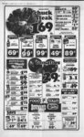
| OCR Text |
Show DAVIS COUNTY CLIPPER. JANUARY CLINTON ABC Katheryn S. Drake & James S. Hayes, Serial No. CLIN 23, Beg 40 ids N of SW cor of Sep 22, 5N, 2W, SLM, N 8 rds, E 80 rda, W 80 rds to beg. cont. 4.00 acres. Total Tax $195.45 David F. & Marie K. Patterson, etal, Serial No. CLIN 25, Beg SE cor of SW Sec 22, 5N, 2W, SLM, N 10 chs, W 20 chs, S 10 chs, E 20 chs to beg. cont. less street 18.75 acres. Total Tax $600.64 D. Kim & Sharon M. Rogers, Serial No. CUN 32-- All of Lot 8, Allred No. 1. Sec 23 T5N-R2SLM: cont. .283 acres. Total Tax $73.89 Joseph W. & D. Ann Robles, Serial No. CLIN All of Lot 13. Allred No. 1. Sec 23 32-1- SLM: cont. .205 acres. Total Tax $366.26 Asset Invest Corp., Serial No. All of Lot 24, CLIN 32-2Allred Sub. No. 2; Sec 23; T5N-R2- SLM: cont. T5N-R2- .21 acres. Total Tax $401.22 D. Kim & Sharon M. Rogers, Serial No. CLIN 32-2All of Lot 25, Allred Sub. No. 2, Sec SLM: cont. .21 23; T5N-R2acres. Total Tax $143.01 Fox & Clark Const. Co., Serial 32-2No. CLIN All of Lot 27, Allred Sub, No. 2, Sec 23; SLM: cont. .21 acres. Total Tax $206.57 Hugh I. & LaVan Gates, Serial No. CLIN All of Lot 48, Allred No. 4. Sec 23; T5N-R2SLM: cont. .21 acres. Total Tax $79.45 Bob B. & Sidona B. Allred, Serial No. CLIN All of lot 49, Allred No. 4, Sec 23; T5N-R2SLM: cont. .21 acres. Total Tax $79.45 Bob B. & Sidona B. Allred, Serial No. CLIN All of lot 51, Allred No. 4, Sec 23; T5N-R2SLM: cont. .45 acres. Total Tax $90.57 Bob B. & Sidona B. Allred, Serial No. CLIN All of lot 52, Allred No. 4, Sec 23; T5N-R2SLM: cont. .22 acres. Total Tax $80.24 Hugh I. & LaVan Gates, Serial No. CUN All of lot 54, Allred No. 4, Sec 23; T5N-R2SLM: cont. .20 acres. Total Tax $79.45 Edward S. & Margaret A. Jack- son, Serial No. CLIN All of Lot 9, Clint Village No. SLM: 1, Sec 23, T5N-R2cont. .265 acres. Total Tax T5N-R2- 32-4- 32-4- 32-5- 32-5- . 32-5- . $338.46 Steven G. & Sharon R. Swaner, Serial No. CLIN All of Lot 38, Clint Village No. 3, Sec 23; SLM: cont. .249 acres. Total Tax T5N-R2- $343.22 William J. & Joyce L. Borrow-maSerial No. CLIN Lot 9, Blk 1, Draaver Sub No. 2, Sec 23, Tp 5N, Rg 2W, SLM: cont. .23 acres. Total Tax $367.06 Gaiy Lee & Gloria J. Wade, Serial No. CUN 38-1All of Lot 10, Eves Garden, Sec 23, T5N-R2SLM: cont. .195 acres. Total Tax $390.10 Wesley M. & Linda Kay Smith, Serial No. CLIN 39-4All of Lot 40, Deanetta Sub No. 2, Sec 26; T5N-R2SLM: cont .19 acres. Total Tax $289.20 Eagle Dev. Corp., Serial No. CLIN 49A-All of Lot 2, Peppermint Park No. 2, Sec SLM: cont. .29 26; T5N-R2acres. Total Tax $69.12 Richard L. & Martha M. Wergin, Serial No. CLIN 49A-All of Lot 7, Peppermint Park No. 2, Sec 26; T5N-R2SLM: cont .231 acres. Total Tax $384.54 Carl H. & Noel Carol Mietus, CUN 53-- Beg at apt N 895522W 835.20 ft alg Serial No. Sec In & N 00439E 333 ft fr SE cor of SWW of Sec 26; T5N-R2SLM: run th N 004'39E 330 ft; th N 895522W 485 ft mol to W In of SEW of SWW of sd Sec 26; th S 00439W 330 ft alg W Sec In; th S 895522E 485 ft mol to pob. cont. 3.674 acres. Total Tax $116.79 Gary T. Lucas Const Co., Inc., Serial No. CLIN 53-Beg at apt N 895522W 835.20 ft alg Sec In & N 00438E 123 ft fr SE cor of SWW of Sec 26; T5N-R2SLM: run th N 540 ft; th N 895522W 485 ft mol to W In of SE'4 of SWW of sd Sec 26; th N 00439"E 657 ft mol alg 'A Sec In to N In of SEW of SWW of sd Sec 26; th E alg sd N In 988.26 ft mol to NW cor of Lot 15, Lazy L" Estates No. 1; th S 14323E 1191.43 ft; th N. Total Tax . . $699.95 Gary L Lucas Constr. Co., Serial No. CLIN 53-All of Lot 1. Lazy L Est. No. 1, Sec 26; T5N-R2SLM. cont. .241 acres. Total Tax $63.56 Garv L Lucas Constr. Co., Serial No. CUN 53-All of lot 5, Lazy L Est. No. 1. Sec 26; T5N-R2SLM: cont. .241 acres. Total Tax $63.56 Garv L Lucan Constr. Co., Serial No. CLIN 53-All of lot 6, lazy L Est. No. 1. Sec 26; T5N-R2SLM: cont. .241 acres. Total Tax $63.56 Constr. Lucas L Co., Serial Gary All of lot 10, No. CLIN 53-1Lazy L Est. No. 1. Sec 26; 00439E SLM: cont. T5N-R2- .241 acres. Total Tax $63.56 Gary L. Lucas Constr. Co. Serial No. CLIN 53-1All of lot 12, Lazy L Est. No. 1. Sec 26; SLM: cont. .241 acres. Total Tax $63.56 Gary L Lucas Constr. Co., Serial No. CLIN All of lot 15, Lazy L Est. No. 1. Sec 26; T5N-R2SLM: cont. .241 acres. Total Tax $143.01 Lucas Constr. Co., Swial Gary L No. CUN All of lot 17, Lazy L" Est. No. 1. Sec 26; T5N-R2SLM: cont. .241 acres. Total Tax $63.56 Lucas Constr. Co.. Serial Gary L of lot 18, No. CLIN lazy L Est. No. 1. Sec 26; T5N-R2SLM: cont. .241 acres. Total Tax $63.56 Gary L Lucas Constr. Co., Serial AU of lot 19, No. CUN Lazy "L Est. No. 1, Sec 26; ; SLM: cont. .241 acres. Total Tax $63.56 Gary L Lucas Constr. Co., Serial No. CUN All of lot 20, Lazy L" Est. No. 1. Sec 26; T5N-R2SLM: cont. .241 acres. Total Tax $63.56 Gary L Lucas Constr. Co., Serial No. CLIN All of lot 24, Lazy L Est. No. 1, Sec 26; T5N-R2SLM: cont. .241 acres. Total Tax $143.01 Arlo C. & Eyvonne E. Fawcett, Serial No. CLIN 57, Beg at apt 90 rods E & 133 ft S fr N W cor Sec 26; T5N-R2SLM: Th . T5N-R2- 53-1- 53-1- 53-1- T5N-R2W- 53-2- 53-2- 24, 1979 S 431.96 ft; ThW 10 rods; Th N 406.96 ft mol to S In ppty conv in 609-4- ; Th E 75 ft; Th N 25 ft; ThE 90 ft to pob. 26; T5N-R2SLM: th W 10 rods; th N 006W 755.04 ft to apt due W of pt of beg; th E 10 rods to pob. cont. 2.86 acres. Total Tax $66.74 David F. & Marie Patterson, etal. Serial No. CUN 64, Beg 32 ids N of SW cor SWW of NEW of Sec 27, 5N, 2W, SLM, E 40 rds, N 28 ids, W 40 ids, S 28 rds to beg. cont 7.00 acres. Also beg NW cor of SWW of NEW Sec 27, 5N, 2W, SLM, E 20 chs, S 5 chs, W 20 chs, N 5 chs to beg. cont 10.00 acres. Cont. in aU 17.00 acres. Total Tax $189.09 James C. & Nancy K. Barnes, Serial No. CLIN 66-5-All of Lot 8, Sandalwood Square No. SLM: 2, Sec 27; T5N-R2cont .385 acres. Total Tax $414.73 Melvin K. & Thelma Douglass, Serial No. CUN AU of Lot 11, Lakeview Gardens No. 1 Sec 27; T5N-R2SLM: cont. .27 acres. Total Tax $391.69 Vance M. & Peggy B. Olney, Serial No. CUN All of Lot 70, Lakeview Gardens No. 3, Sec 27; T5N-R2SLM: cont. .23 acres. Total Tax $442.54 Eagle Dev. Corp., Serial No. CLIN All of lot 8, Peppermint Park No. 5, Sec 27; T5N-R2SLM: cont. .24 acres. Total Tax $15.10 Martin A Jr. & Darlene Overdiek, Serial No. CLIN 70, Beg on N In of St Hy 31 ft, m or 1, N & 753.7 ft W fr SE cor NEW Sec SLM: Th W 27; T5N-R2153 ft; alg sd Hy; Th N 2207E 406.42 ft; Th S 376.44 ft to pob. cont .67 acres. Total Tax $67.53 Fred J. & Berlinda Chavez, Serial No. CUN 78, Beg 60 rds N of SE cor of SEW Sec 27, 5N, 2W, SLM, N 10 rds, W 80 ids, S 10 rds, E 80 rds to beg. cont. 5.00 acres. Total Tax $375.80 Dennis W. & Sally J. Pettingill, Serial No. CUN 91A-AU of Lot 5, Muir Sub, Sec 27; T5N-R2SLM: cont. .245 acres. Total Tax $367.85 Douglas Allen & Vickie T. Tanner, Serial No. CLIN AU of Lot 15, A1 Vi Village. Sec 27 T5N-R2SLM: cont. .198 acres. Total Tax $373.42 Larry C. & Patricia S. Maughan, Serial No. CLIN AU of Lot 25, A1 Vi Village, Sec T5N-R227, SLM: cont. ,265 acres. Total Tax . $413.14 Nolan G. Muir, Serial No. YJUN 93-- Beg on E In of cert st S 55 rds 12.5 ft & E 1.5 rds fr NW cor of NWW of SEW Sec 27, T5N-R2SLM, N 90 ft; E 130 ft; S 90 ft; thW 130 ft to beg. cont .268 acres. Total Tax $436.98 Deka Investments, Inc., Serial No. CLIN 94 A, Beg 120 ft S of S In of a St 926.5 ft E & 156.3 ft S of NW cor of SEW of Sec 27; T5N-R2SLM: run th E 102 ft; th N 156.3 ft to 'A Sec In; th E 203.5 ft; th S 156.3 ft; th E 88 ft; th S 998.7 ft; th W 393.5 ft; th N 998.7 ft to pob. Excepting Hy rw on N 36.3 ft thereof, cont. 9.65 acres. Total 1, Tax. $11.92 Lyle F. & Rhea Aven Nielson, 125-Serial No. CLIN AU of Lot 7, Mountair Park No. 1, T5N-R2Sec 28; SLM: cont .19 acres. Total Tax $406.78 Robert P. Ill & Ann R. Strebel, 125-1Serial No. CUN AU of Lot 16, Mountair Park No. 1, T5N-R2Sec 28; SLM: cont. .19 acres. Total Tax $341.64 Elizabeth R Moulton, Serial No. 125-3CLIN All of lot 33, Mountair Park No. l; Sec 28; T5N-R2SLM: cont. .185 acres. Total Tax $347.20 Ronald L. & Gaydene E. Schofield, Serial No. CLIN of Lot 44, Mountair 1, Sec 28; T5N-R2SLM: cont. .19 acres. Total Tax $137.48 RusseU W. & Brenda C. Storey, Serial No. CLIN All of Lot 77, Mountair Park No. 2, T5N-R2Sec 28; SLM: cont .217 acres. Total Tax AU Park No. 125-7- Joanne 125-8- in cen of a county id at a pt ft S fr NE cor of SE'4 of Sec 29; T5NR2W; SLM: Th W 1114.84 ft; th S 615r W 229.67 ft; Th E 1317.53 ft; Th N 108 ft to pob. cont. 3.00 acres. Total Tax $492.59 Richard NeU & Beverly J. Evans, Serial No. CUN 171, E'4 of the NW'4 of NEW of Sec 33, 5N, 2W, SLM, cont. 10.00 acres. Total Tax $816.75 Douglas A. & Ro Layne D. Poll, Serial No. CLIN 180, Beg at apt 44 ids E & 40 rds S of NW cor of NEW of Sec 33; T5N-R2SLM; th E 132 ft; th N 627 ft to S In of st; th W 132 ft algadst; thS627 ft to the pob. cont 2.02 acres. Total Tax LeRoy H. SLM: Th E $122.35 Verla N. Langford, Serial No. CUN Beg W 792 ft alg W sec line fr EW 185-1-- 5, cor Sec 34, T5N-R2SLM: th W 132 ft; S 330 ft; E 132 ft; th N 330 ft to beg. cont. 1.00 acre. Total Tax $393.28 Duffy & Jocelyn J. Palmer, CO John A. Chavez, Serial No. CUN 193, Beg 540.375 ft fr SE cor of NEW Sec 34 T5N-R2SLM, N 80 ft; W 300 ft; S80fi; th E 300 ft to beg. cont. .625 acres. Totel Tax . $315.42 Candido Archuleta, Serial' No.. CUN 206-- Beg 2140.7 ft S fr th NW cor of Sec 35, Tp 5N, Rg 2W, SLM, E 258.0 ft, th NWly alg sd rw 89.4 ft, th W 257.0 ft, S 89.4 ft to beg. cont. .82 acres. Total Tax . . $193.86 Lola S. Bumett Jones, Serial No. CUN 217, Beg at a pt S 302.7 ft fr NW cor of Sec 35, 5N, 2W, SLM, S 139.62 ft, E 175.14 ft to Wly RW line D. & R.G. Ry, NWly alg sd line 139.8 ft, W 168 ft. to beg. cont. .55 acres. Total Tax $179.56 ' $313 03 B. Cox, Serial No. CLIN AU of Lot 80, Mountair Park No. 2, Sec 28; T5N-R2SLM: cont. 217 acres. Total Tax $353.55 Lola J. Wunderlich, Serial No. AU of Lot 83, CUN Mountair Park No. 2, Sec 28, T5N-R2SLM: cont. .193 acres. Total Tax ..'... $273.31 Cedi L & Arthelia Lucille Dalton, Serial No. CLIN 126-Beg 206 ft E of A cor common to Sec 28 & 29, T5N-R2SLM; th E 134 ft; N 179.1 ft; W 134 ft; S 179.1 ft to beg; excluding therefrom, the S & ft for road, cont. .45 acres. Total Tax $369.44 Paul B. Baker, Serial No. CLIN 158A-4A1I of Lot 41, Fuit No. 5, Sec 29; T5N-R2SLM: cont. 1.00 acres. Total Tax $132.68 Dean A. Fuit, Serial No. CLIN 158A-42AU of Lot 42, Fuit No. 5, Sec 29; T5N-R2SLM: Except S 120 ft thereof, cont. .75 acres. Total Tax 125-8- $59.59 Horace R & Virginia H. Oleson, Serial No. CLIN 161, E'A of NW'4 of SE'4 Sec 29, 5N, 2W, SLM, cont. less Hy, 18.481 acres. Total Tax $205.78 Jay LaMar & Nola F. Batchelor, Serial No. CLIN 162-- Beg at pt 38 rds N fr SE cor of NE'4 of SE'4 of Sec 29, Tp 5N, Rg 2W, SLM, N 10 rds, W 16 rds, S 10 ids, E 16 rds to beg. cont. 1.00 acres. Total Tax $265.36 Marvin O. & Madelyn T. Evans, 162-Serial No. CLIN Beg at apt 278 ft S alg Sec In fr NE cor of SE'4 of Sec 29. T5N-R2SLM: & run the S 125 ft alg sd Sec In; th S 8038'W 182.43 ft; th W 249 ft; th N 79.69 ft; thE 249 ft; thN 58.51 ft; th N 8446E 180.75 ft to pob. Except portion in road alg E In thereof, cont. 1.03 acres. Total Tax $579.99 Ronald H. & Joleen B. Stewart, 162-Serial No. CLIN Beg at a pt W 180 ft fr E'4 cor of Sec 29; T5N; R2W, SLM: th W 249 ft; thS 353 ft; thE 249 ft; th N 353.0 ft to pob. cont. lesB road, 2.00 acres. Total Tax $794.50 CJ. & Re'ta J. Roekelley, etal, 162-1Serial No. CLIN Beg ABJ ,j Egan E. Clark, etal, Serial No.' SW7,Beg 1620ft EfrSWcor of Sec 26; T5N-R1SLM: run th N 500 ft; th E 855 ft; th 5 334 ft; th W 263 ft; th S 166 ft; th W 70 ft; th N 467 ft; th W 222 ft; th S 467 ft; th W 300 ft mol to pob. Cont 4.74 Acres. Total Tax $298.96 Egan E. Clark & Ruby C. Tuck, Serial No. S.W. 9, Beg 2442 ft E, 33 ft N fr SW cor of Sec 26, 5N, 1W, SLM. on N line of Co. road running E and W and the W line of Co. road running N and S at the intersection of these lines, W 263 ft, N 166 ft, E 263 ft, S 166 ft to beg. Cont. 1.00 Acre. Total Tax $64.22 George R. Wright, Serial No. S.W. 13, Beg W 624.4 ft & N 33 ft fr SE cor of Sec 27, T5N-RlSLM: th W 199.6 ft m or 1 to grantors W ppty In, Th N 196.2 ft to an exist fence; Th S 8726E 316.3 ft. Th S 141E 92 ft; Th N 8937W 123.9 ft; th S 131 E 92.3 ft m or 1 to pob. Cont 1.1 Acre. Total Tax $243.30 George R. Wright, Serial No. S.W. 13-W 330 ft & N 33 Beg ft fr SE cor of Sec 27; T5N-R1SLM: Th N 024W 1287 ft alg grantors E ppty In; Th W 964.7 ft to NW cor of Grantors ppty; Th S 119E 182.6 ft alg exist fence, Th S 7812E 383.2 ft alg exist fence. Th S 011E 593.8 ft alg grantors W ppty In to pt N 468.6 ft fr S In of sd Sec 27, Th E 109.2 ft; Th S 239.4 ft, Th S 8726E 316.3 ft, th S 141E 92.0 ft th 8937W 123.9 ft; th S 92.3 ft to N In of Co. E 293.3 Road; Th ft to pob. Cont 17.9 Acres. Total Tax $344.18 Merlin & Geraldine Daines, Serial No. S.W. Beg on Nly rw In of St Rd at pt N 8942' W 2209.59 ft alg S sec In & N N 131E 008E 133.94 ft para with E sec In fr SE cor Sec 27; T5N-R1SLM: th N 319W 212.12 ft to SE cor ppty conv in 402-22Th N 03240E 185.63 ft to a pt on S line of Canyon Drive Sub; No. 2; S 894140 E 12.38 ft alg sd S Iji th E 008'W 403.95 ft to pob. Cont. ,09 Acres. Total Tax $2.85 Thomas J. & Joyce Stanger, Serial No. S.W. All of Lot 6, Canyon Drive Sub No. 3. Sec 27, T5N-R1SLM: Cont. 1.10 Acres. Total Tax $321.79 Steven M. & Linda Jo Ann Westbroek, Serial No. S.W, All of Lot 30, Canyon Drive No. 2. Sec 27 T5N-R1SLM: Cont. .385 Acres. $363.17 Michael L & Deborah S. Ogden, Serial No. S. W. All of 2, Canyon Drive No. 3, Sec Total Tax It 27, T5N-R1.565 Acres. SLM: Cont. Total Tax $348.19 Delmer B. & Patricia A. Hatfield, Serial No. S.W. Beg on N In of a st. N 436'50E 50 ft 6 S 8523'10 E 430.81 ft fr NE cor Lot 1. Canvon Dr. Sub. of pt of Sec 27, T5N-R1SLM: th S 852310E 85 ft alg ad St; th N 43650E 194.94 ft. mol, to S In of Interstate Hy; th S 8956'W 85.6 ft alg ad Hy; th S 4 3650" W 187.78 ft to pob. Cont. .363 Acres. Total Tax ... . $198.13 t 11 to pob. Cont .027 Total .827 $496.93 Acres. Total Tax Murray S. Sr. & Norma L. MofBeg fat, Serial No. A at SW cor lot 5 D, Blk 4, lifted T2N-RlPark, amend Sec 36; SLM: Th N 100 ft; Th E 30 ft; Th SEly 95.62 ft to a pt 51 ft N & 37 ft W fr SE cor sd lot; Th E 37 ft; Th S 51 ft; Th W 148 ft to the pob. Cont. .275 Acres. Total Tax $598.64 Hugh L. & Ella K. Williams, No. A Serial Beg 9 ft SEly alg N side of Crestview Circle fr SW cor Lot 10, Blk 6, ft; Th S lrfred Park Sub. Amended; T1N-R1SLM, th SEly following sd N side of Crestview Drive 18.1 ft; N 885745E 101.7 ft, th alg a 106 ft rad curve to the right 14.87 ft to SE cor Lot 11, N 04645W 169.33 ft, S 891315W 222.04 ft, m or 1, to Sec 1, ppty to beg. Cont. .49 Acre. Total Tax $584.11 S.D. Sewer 100 ft; Th N 034W 435.6 ft to S line sd rd; Th S 894430E 100 ft alg S A120-6-3- lifted Park Sub. Sec 1 Tp IN Rg 1W SLM Cont. .49 Acres. Amended Plat. Total Tax $551.41 Mel K. & Elaine W. Melcomian, Serial No. A Pt of Lot 32, Blk 6, lrfred Park, Amended Plat. Desc as foils; Beg S 1357E 371.98 ft fr NW SLM: cor of Sec 1, T1N-R1& run th N 8959E 150 ft; th S 001E 107.65 ft; th N 8959E 146.85 ft to W In of Lot; th N 022E 212.70 ft to Sin of St; th NWly 63.15 ft alg a 120 ft rad cur to right; th N 603740W 145.15 ft Ely In of St Road; th SWly alg sd In of road alg a 14374 ft rad cur to right, 218.57 ft to pob. Cont. 1.05 Acres. Total Tax $787.53 Frederick A. & Beth W. Serial No. A All Lot 1, Blk 7 Amended, lifted Park in Sec 1, Tp IN, Rg 1W, SLM, Cont .51 Acres. Total Tax $472.95 Ban-gerte- r, 120-7-- S.D. Sewer $41.00 Don S. & Myma Irene Milligan, Serial No. A 125-1Lot 16, Pedersen Sub. Sec 1. Tp IN. Rg 1W. SLM. Cont. .248 Acres. Total Tax $486.03 William E. & Roberta L. Jones, Serial No. A 125-2Lot 29. Pedersen Sub. Sec 1. Tp IN. Rg 1W. SLM. Cont. .248 Acres. Total Tax $417.74 Mary G. Monson, Serial No. A 129-Beg 288.6 ft S 005E & 921.7 ft N 3514W S 1. T1N-R1- 5446E 190 ft, m or 1, N 3506E to pt S 6454E of beg, th N 5454W to beg. Cont. Total Tax . $584.11 S.D. Sewer ; $41.00 Raymond L. & Marion E. Flory, 129-2Serial No. A Beg at apt . 1137.4 ft Ely and 87.7 ft S 3514W fr NW cor of SEW of Sec 1, T1N-R1SLM: Th S 35 14 W 66 ft. Th S 5446E 317.2 ft. Th N 021W 81.2 ft. Th N 5446W 270 ft. to pob .48 Acre. Total Tax . . $103.89 Hugh B. & Sarah H. Allred, Serial No. A Beg 288.6 ft S 005E & N 8856E 536 ft alg S In of st & S 005E 143 ft & S 2257W 47.5 ft fr cen Sec. 1. .508 Acre. .' . 128-Beg at the NE cor of the SWW, NEW of Sec 29; T5N-R1- SLM, S 522740E ft to Wly In of st. S 3512W 54.7 ft to pt of tang with a 1885.08 ft rad curve to right, th SWly 32 ft, m or 1, alg sd curve, N 5230 0W 152.99 ft, N 2257E 90 ft to beg, cont. .33 Acre. Total Tax . . $554.32 Sheldon K. & Susan A. Green, Serial No. A 129A-2Lot 22. Oakleaf Sub. Sec 1, Tp IN, Rg 1N-1- 174.58 1W, SLM. Cont .27 Acre. To- tal Tax $480.94 Ivon Ray Wall, Serial No. A 129B-1- , Lot 1, Oakleaf Sub, Plat B, Sec 1, TIN R1W, SLM; Cont. .37 Acre. Total Tax $873.98 IVon Ray Wall, Serial No. A 129B-2Beg at SE cor lot 2, Oakleaf Sub, Plat B; Sec 1. T1N-R1SLM: Th N 00604W 95.85 ft; Th N 7225W 88.24 ft; Th S 679-53- Dick L & Dixie Gledhill, Serial No. A 35-Beg on Eiy In of st N 8952W 1235.1 ft & N 4318E 1219.8 ft & S 7005E 18 ft to pt 33 ft distant SEly fr cen In sd st fr SW cor Sec 1, T1N-R1SLM N 43 17E 92 ft; S 7005E 234.2 ft; S 4645E 70.2 ft; S 2753W 133.5 ft; th N 6955W 203.80 ft to pt 147 ft S 6955E of Ely In sd st; th Nly to pt 120 ft S 7005E of beg; N 7005W 120 ft to beg. Cont. .955 Acre. Total Tax $595.00 S.D. Sewer $41.00 Heinz & Irmgard Koenig, etal, 13-1 Serial No. A Beg on E In of 100 ft St Hy at pt wh is W 322.08 ft & N 892,50 ft alg cen In of a 66 ft St & N 8930W 540.95 ft fr SE cor of NWw of Sec 1. T1N-R1SLM: & th N 312930E 87.49 ft alg sd E In; th S 8930E 150 ft; th S 75 ft; th N 8930W 195.70 ft to the pob. Cont. .297 Acres. Total Tax $190.34 Eldon Loy & Donna M. Martin-dal- e, 118-Serial No. A Beg 35.7 ids S & 49.81 rds W fr NE 1 1 cor SWW Sec , Tp N, Rg 1 W, SLM, W 11.19 rds, S 5 rds, E 11.19 rds, th N 5 ids to beg. Cont.35 Acres. Total Tax $550.69 Eldon Loy & Donna M. Martin-dal- e, 118-3A Serial No. Beg 30.85 rds S & 49.81 ids W & 76.2 ft SfrNE cor SWW Seel. TplN, Rg 1W SLM, W 11.19 rds. S 3.8 ft E 11.19 rds. th N 3.8 ft to beg. Cont. .03 Acre. Total Tax $2.91 Gale Snow & Helen F. Bird, Serial All that No. A part jot 6B, Blk 1, lrfred Park Sub. Sec. 36, Tp 2N, Rg 1W, & SLM, th SWly alg SEly In of Orchard Drive 115.57 ft, S Kendell, Serial No. S.W. COUNTY A ABEGJ 8856E 412.53 ft fr NW cor SEW Sec line sd rd to pob. Cont. 1.00 Acres. Total Tax $64.22 Melvin Lee & Lorraine Cooney SLM: & run th S 056 W alg old fen 149.43 ft; th W 86.5 ft th N 056E 149.43 ft; th W 146 ft; th N 056E 60.90 ft E 146 ft to Grantors E ppty In 'defined by old fen; th S 056W alg old fen 60.90 ft to apt on the W W In & W 86.5 ft fr th pob; th E 86.5 ft to the pob. Cont. .50 Acres Subj to a rw 25 ft wide over the most Wly $57.08 portion. Total Tax Clarence M. & Ethel S. Maurer, Serial No. S.W. 149, Beg at apt on NWly In of a Hy. sd pt being N 4841E 1098.31 ft & N 625W 130 ft & S 7140E 354 ft & N 3456 E 171.72 ft fr SWW of NWW of Sec 36; T5N-R1SLM: th N 3456E alg sd NWly In of Hy. 500 ft, mol, to N In of SWW of NWW of sd Sec 36; th W alg sd In 691 ft, mol to NE cor of th S ppty conv in 625E 440 ft, mol to a pt 30 ft N of N In of William Zitfr ppty; th S 7140E 95 ft; th N 3456W 140 ft; th S 7140E 165 ft, mol, to pob. Cont. 4.09 Acres. Total Tax ... . $439.52 $41.00 Betty Douglas, Serial No. Lot 31; Block 6 & JoAnn B. Reynolds, Serial No. S.W. 116-A parcel of land located in the SWW of Sec 28; T5N-R1SLM: Beg at the WW cor of sd Sec 28 & run th N' 8933E 678.4 ft; th S 541E 88.3 ft to the true pob; th E 125.2 ft; th S 2148 E 162.7 ft to an exist fen In (wh para So. Weber Drivs N rw In): th N 8421W 172.8 ft; th N 541W 134.8 ft mol to the pob. Cont. .48 Acres Together with a rw. Total Tax $255.43 Ronald L. & Colleen C. Kendell, Serial No. S.W. 125-Beg on S line of a rd, sd pt being S 319.79 ft & E 1220.83 ft fr NW cor Sec 29; SLM:., Th S 034W 435.6 ft Th N 894430W M. ' T5N-R1- u1 Patricia Cont. .80 Acres. Amended Plat. Also Beg at the NE cor of Lot 11, Blk 1 lrfred park Amended Plat th S 027E 10.50 ft alg the E In of sd Lot 11; th N 8912W 140.04 ft; th N 027W' 6.64 ft; th N 891315E alg N In of sd Lot James Warren SOUTH WEBER .; 153.1 & Cahoon, Serial No. A 120-1-1- 0, Lot 10, Blk 1, lrfred Park Sub. Sec 36 Tp2N, Rg 1W, SLM. $228.32 Tom T. Ogino, Serial No. S.W. 84 A, Beg SE cor NW of SEW Sec. 19, Tp 5N, Rg 1W, SLM, W 1.43 chs, N 12 E to Cen In Co. Road, th alg cen In Co. Road to E Sec. line Sec. 19, S to beg. Cont. .104 Acres. Total Tax $2.85 IUona R. Stevenson, Serial No. S.W. 98, Beg 146.7 ft S & 234 ft W fr SE cor of Sec 20, T5N-R1SLM: th N 8754 W 193.6 ft; th N 46W 111.8 ft; th 5 8754 E 194.52 ft; th S 115W 111.8 ft, mol, to pob. Cont. .50 Acres. Total Tax $171.95 Charles Thornhill & Patricia N. Law, Serial No. S.W. 103-1- , Beg N 022'W 222.68 ft & S 8526W 222.52 ft to W sd of rw & N 011220E 351.02 ft 6 S 8526 W 60.95 ft fr SE cor of Sec 20, T5N-R1SLM: th N 92145W 97.03 ft to pt wh is 130 ft perp dist SWly fr cen In of an off ramp; th N 504507W 144.98 ft; th S 11130W 197.43 ft; th N 8526E 133.63 ft to pob. Cont. .46 Acres. Total Tax . . . $7.85 & it .... James LeRoy 145.7 ft, m or 1, to N line of Max Wilson Ppty; Th W 153.1 ft to a pt S of beg; Th N 145.7 ft to pob. Cont. .515 Acres. Total Tax $14.98 James Edward Freed, Serial No. S.W. 66-Beg 1 170 ft S fr N W cor Sec 35; T5N-R1SLM: Th S 150 ft; Th E 300 ft; Th N 150 ft; Th W 300 ft.mor 1, to pob. Cont. 1.03 acres. Total Tax $468.06 Cecil, Donald E. & Kenneth Byram etal, 'Serial No. S.W. 67, The SEW of NWW of Sec 35, Tp 5N, Rg 1 W, SLM. Cont. 40.00 Acres. Total Tax 180-2-- j SLM, which lies S of a In run S 891315 W fr NW cor lot 6A, Blk 1, of sd Sub. Cont. .46 Acres. Total Tax $426.46 SLM: Sd pt being in roadway; Th E 299 ft; Th S 145.7 ft, m or 1, to N line of Max Wilson ppty: Th W 299 ft to pt S of beg; Th N 145.7 ft, m or 1 to pob. Cont. 1.00 Acres. Total Tax $411.69 Robert L. & Linda H. Flinders, Serial No. S.W. Beg at pt 464.3 ft S & 299 ft E fr NW cor sec 35; T5N-R1- Brown, Serial No. CLIN Beg at apt S 001E 321.97 ft of NW cor of NEW of Sec 33; T5N-R2SLM: run th N 8959E 215.75 ft; th N 00635E 288.97 ft; th E 360.25 ft; th S 600 ft; th E 150 ft; th S 687 ft; th W 44 rods, th N 998.03 ft to pob. cont. 17.74. Total Tax $1,955.26 Albert DeMar Mitchell, etal, LaVon D. CO trustees, Mitchell, Serial No. CLIN 182, Bet 60 rds E fr NW cor of SEW of NWW of Sec 33; T5N-R2SLM: run th S 80 rds, mol, to S In of MVW of sd Sec 33; th N 895853 W 8.07 ft to SE cor of Valley West Ranches Sub; th N 13848 W 1325.24 ft to NE cor of Lot 9, sd Sub; th E 46.15 ft to pob. cont .824 acres. Total Tax t & Venice T5N-R1- $324.95 Evans Aircraft Ind., Inc., Serial No. CUN 180-2-Beg in cen of county road at pt 60 rds E & 40 rds S fr NW cor of NEW Sec 33, Tp 5N, Rg 2W, SLM, S 40 ids, W 16 ids, m or L N 40 rds, th E 16 ids to beg. cont. 4.00 acres. Total Tax $572.83 Dale E. & Luella Workman, Serial No. CUN 180-2-Beg at apt 576 ft E fr NW cor of NEW of Sec 33, T5N-R2SLM: th E 25 ft th S 348 ft; th E 125 ft; th S 252 ft; th W 150 ft; th N 600 ft to pob. cont. 1.06 acres. Reserving unto grantor rw alg entire E side of above desc tract. Total Tax $541.85 A. Richard & Jacqueline A. John A. Page 12 25, 1 979 Poll, Serial No. S. W. 23-- Beg on N In of a road 710 ft N & S 8615E 258.6 ft alg sd rd fr SW cor Sec SLM, N 273.75 27, T5N-R1ft, S 86 15E 111 ft, S 273.75 ft to N In sd rd N 8615W 111 ft to beg. Cont. .695 Ac. Total Tax $437.38 Thomas Joseph & Joyce Stanger, 51-Serial No. S.W. Beg 1055.00 ft & E fr NW cor of NEW Sec 34, Tp 5N, Rg 1W, SLM, th E 52.10 ft, S 396 ft, N 6945 W 55.45 ft, th N 377 ft to beg. Cont. .462 Acre. Total Tax $187.65 Robert L. & Linda H. Flinders, Serial No. S.W. Beg at pt 464.3 ft S fr NW cor Sec 35 928.8 $375.00 Mountair Homes Inc., Serial No. CLIN 125, Beg 5 chs E of NW cor of SWW of Sec 28 T5N-R2SLM: Th E 12.70 ft to NW cor Mountair Park No. 1; Th S 1320 ft alg W In of Mountair Park No. 1 & 2; Th ' W 12.70 ft; Th N 1320 ft to pob. cont. .38 acres. Total Tax 125-4- DAVIS NEWS JOURNAL, JANUARY WEEKLY REFLEX 63925E . 123.36 ft; Th N 895920E 70 ft to pob. Cont. .18 Acres. Total Tax . . . $7.99 Deseret Construction, Inc., Serial No. A 129B-4Beg at SE cor of Parcel 4A, Oakleaf Sub. Plat B", a sub of pt of Sec 1, SLM: T1N-R1- 7315E 28.61 ft; th S th N 3530E 114.06 ft; th N 49 W 130. 93 ft to a pt 14.08 ft S 17 W alg E In of St fr N cor of sd Parcel 4A; th S 17 W 69.92 ft alg sd St; th Nly 94.63 ft alg arc of a 225 ft rad cur to the right alg sd st to SW cor of sd Parcel 4A; th S 73 E 73.71 ft to pob. Cont. .375 Acres. Total Tax .... $472.95 s Amell E. Heaps, Serial No. A 129D-1All of Lot 18, Oakleaf D Sec 1; T1N-R1SLM: Cont. .276 Acres. Total Tax $740.30 Mervin A. & Vivian R. Lee, Serial 129D-2No. A All of Lot 20, Oakleaf Sec 1; T1N-RlW- ; SLM: Cont. .233 Acres. Total Tax $123.51 Dee A. & Arlene Moultrie, Serial 129D-2No. A All of Lot22, Oakleaf Sec 1; T1N-R1SLM: Cont. .229 Acres. Total Tax $123.51 "D; D, Alan L & Tamara M. Colllins, AU of Serial No. A 129D-2Lot 27, Oakleaf D; Sec 1; T1N-R1SLM: Cont. .230 Acres. Total Tax .... $553.59 Bernetha Bland, Serial No. A Beg at SE cor lot 3, Brown Sub. Sec 1. T1N-R1SLM; th N 8943W 64.80 ft; N 802'W 43.79 ft; N 4418W 6.40 ft; N 027W 48.0 ft to S In of a st; th E 50.20 ft alg sd st; th E'ly 39.07 ft alg arc of a 25.0 ft rad curve to right alg sd st; th S 027E 71.41 ft alg W In sd st to beg. Cont .15 Acre. Total 155-3-- Ta, $432.27 Alfred W. Jr. & Joyce R. Troth, 155-5-No. A All of the Serial W 85 ft of Lot 5, Brown Sub. Cont. .16 Acres. ALSO: Beg at apt 373.8 ft E & 463 ft S of the NWcor of the NEW of Sec 1; T1N-R1SLM: Th S 109 ft; Th W 85 ft; Th N 109 ft; Th E 85 ft to pob. Cont. .21 Acres $685.82 Albert G. & Shirley J. Lawrence CO Joseph Bosch, Serial No. A 155-Lot 7, Brown Sub. Sec L Tp IN. Rg 1W. SLM. Cont .30 Acres. Total Tax . $261.54 Carol Y. Sanders CO Hugh & Ella Williams, Serial No. A 155-Lot 8, Brown Sub. Sec 1. Tp IN. Rg 1W. SLM. Except the E 90 ft thereof. Cont. .20 Acre. Total Tax $198.33 Claudia Rosetta Rex, Serial No. 169-A Beg on E sd of Hy No. 2. 1827.8 ft S & 3900.3 ft, mol, NW W fr cor of Sec 6, T1N-R1SLM: th alg E side of sd Hy S 048E 25 ft; th N Authority, . ft; th N 895230E 257.75 ft; th N 12240W 99.86 ft; th W 437.6 ft to pob. Cont. .70 Acres. Total Tax .. $1,633.90 Clive Le Roy & Christine Pulham, Serial No. A AU of the E 142 ft of Lot 37, Orchard Acres Sub. Sec. 1, Tp IN, Rg 1W, SLM. Cont. .209 Acres. Total Tax .... $295.69 178-3- .... 430-43- 432-3-- 432-5-1- the. W line ppty conv in Th N 122 ft; m or I, to a pt 200 ft N fr S line sd lot 5; Th W 32.1 ft, m or 1, to NEcor th S ppty conv in 209-21542W 207.74 ft to S line lot 4, Blk 1. sd sub; Th E 70.32 ft to pob. Cont .245 Acres. 5.- D. Sewer $41.00 Lee K. & Diane Francis, Serial No. A 445-Lot 2, Stanley Circle Sub, Sec 6, Tp IN, Rg IE, SLM, Cont. .23 Acre. Total Tax $423.55 William C. Bradshaw etal, Serial 2 No. A A, Beg 10 ft S fr NW cor lot 22, Blk 1, Plat A, 2791572; 3 445-1-2- Val Verda, Sec 6, T1N-R1SLM th E 106 ft; S 78.6 ft; W 106 ft; th N 78.6 ft, m or 1, to beg. Cont. .19 Acre. Total Tax $264.45 Ivan Franklin Jr. & Velma Kay Wood, Serial No. A 445-1-2Beg at SE cor lot 27, Blk 1, Plat A, Val Verda Sub. Sec 6. T1N-R- 1 E. SLM; th W 85 ft; N 247.6 ft; th E 85 ft; th S . See Assessors Card. Total Tax $385.77 Alma C. Clark, Serial No. A 445-2-Lot 1, Blk 2, Plat A, Val Verda, Sec. 6 TIN-RlSLM: Cont. .82 Acres. Total Tax $136.58 Alma C. Clark, Serial No. A 445-2-- 2, Beg at SE cor lot 2, Blk 2, Val Verda Plat A sec 6. TIN-RlSLM: Th N 99.65 ft alg E ln of sd lot to a fence; Th S 8954W 302.73 ft to E ln of a st; Th S 4036W 129.85 ft alg sd st to SW cor lot 2, blk 2; Th E 393.6 ft to pob. Cont. .795 Acres. Total Tax $502.74 Clark & Rula K. Maughan, Serial No. A 445-2-Beg at NE cor Lot 6, Blk 2, Val Verda Plat A, Sec 6, TIN-RlSLM; th W 115 ft; S 150 ft; E 115 ft; th N 150 ft to beg. Cont. .395 Acre. S.D. Sewer $41.00 Ralph D. & Joyce C. Frasier, 445-3-1Serial No. A Lot 19, Blk 3, Plat A. Val Verda, Sec 6, .... TIN-RlE- , SLM; except the West 25.0 ft thereof. Cont. .81 Acre. Total Tax $601.55 Arnell E. Heaps, Serial No. A 161-Beg at a point wh is the S cor of Lot 12, Oakleaf Sub Plat C; Sec 1: T1N-R1- drainage canal; th NWly following 4 courses alg sd canal bank; N 3837 20 W 165.70 feet; th N 491605 W 133.96 ft; thence S 884642 W 64.51 feet; th N 6305 W 58.03 ft to existing SEly rw ln of Belt Route known as th SWly following 3 courses alg sd rw ln; S 664411 W 164.71 ft; th S 594515 W 442.52 ft to a ; ; . , of SEW of Sec 14, T2N-R1SLM: desc as foils: Beg $171.87 Carolyn H. Kaiser-ma- n, Serial No. A 645, Beg on N Une of a 50 ft rw at a point N 895921 E 1339 ft, mol & South 1060 ft, mol, fr cen Sec 14; T2N-R1- SLM: thence S 892510 E 525.87 ft, mol, to W ln of W.B. Town; thence N 02053 W 717.94 ft; thence W 521.96 ft to NE cor Baumans ppty; thence S 712.30 ft to pob. Cont. 8.598 acres together with rw; Less 3 1.00 Ac. Balance to & 7.598 Acres. Less to Remainder 1.178 Acres. Total Tax $32.97 WilUam R & LaRue T. Bauman, Serial Na A 645-Beg at a point on N ln of 50 ft rw 80 rds W & 1022.50 ft S of NE cor of SEW Sec 14; T2N-R1SLM: thence N 713 ft m or 1; thence E 123 ft; th S 713 feet, m or 1, to N ln sd rw; thence W 123 ft to pob cont. 2.025 Acres Together with rw. Total Tax $117.85 Americhem Ind., Inc., Serial No. 616-15- 656-36- 4 643-26- A 645-Beg atapointonWln of W. Bo. City, said pt being N 8947n E 1860.94 ft and S 03210 E 364.73 feet fr center of Sec 14; T2N-R1SLM: run th S 895759" W 312.79 feet alg an existing fence to a fence cor; thence S 02407 E 713.73 ft alg an existing fence to N rw In of a 50 ft rw; thence S 895108 E 202.47 ft along N ln of said rw; thence N 03210 W 388.93 feet; th S $1,680.79 & Loralee Clegg, Serial No. A 651-Beg at a point on N ln of 1200 N St. sd pt being S 00254 E alg Sec ln 2200.88 ft 6 North 895626 E alg sd N ln 625 ft fr WW cor of Sec 14, T2N-R1SLM: thence N 895626 E alg sd N ln 125 ft; thence N 00254 W 735.47 feet; th W 125 ft; th S 00254 E 735.60 ft to pob. Cont 2.111 Acres S. D. Sewer $18.50 Edward M Mabey & Owen W. Bunker, Serial No. A 652, Beg' at NW cor of SEW of Sec 14, T2N-R1SLM: thence N 894711 E 1320 feet, mol along the W Sec In; th S 1072.50 ft th W 310.64 feet mol to pt 1071.04 ft South & 1005.304 ft E fr sd NW cor; thence N 02131 W 501.36 ft; th W 6.284 ft, mol; thence N 02131 W 242.96 feet; th S 895457 E 227.010 ft; th North 04344 W 264.318 ft; th S 894338 W 224.91 feet; thence W 600 ft; th S 02131 E 251.31 ft; th E 100 ft; th S 02131 E 251.775 feet th E 106.28 ft, mol; th S 02131 E 501.36 ft; th W 605.30 feet mol, to W Sec ln; th N 03703" W 1071.04 ft along sd W sec ln to pob. Cont. 19.825 Ac. Together with & Subject to a rw Less 534-57573, 574, 575 Remainder 10.195 Acres Ex560-61- 6 Remainder 2.515 cept Acres. Total Tax $91.20 Loran J. Clark, Serial No. A 652-Beg at point 1949.26 ft W and 1643.5 feet S & 258.26 ft W fr NE cor of SEW Sec 14 T2N-R1SLM: thence W ... 1071.04 ft & E 405.304ft fr cen .; SLM: of Sec 14 T2N-R1th N 021 W 501.36 feet th E... 100 ft; th S 021 E 501.36 ft to N ln of said exist gravel road; ; t th W alg a fen ln 100 ft to pob. , . Cont. 1.15 Acres TOGETHER. ;; with & subject to rw. Total Tax $48.40;, Stanley D. & Anne H. Madsen, Serial No. A Beg 351 669-- feet E fr cen Sec 23, SLM: th N 340 ft, T2N-Rl- A 671, Beg 27.88 chs W & 13.75. chs S from NE cor of Sec 23, T2N-R1- 209.66 ; m or 1, to S Une of a st; th E alg S ln said st 128 ft; th S 340 ft, m or L to point E of beg; th W 128 feet to beg, cont. 1.00 Acre. : Weber Water $33.12 Donald E Curtis, etal, Serial No. . . r ; SLM: thence S, ft, mol, to NE cor ; of.; th S ppty conv in 894942 W 659 ft alg sd N In;. th S 01018 E 198.3 feet; th N 894942 E 660.94 ft; th S . 582.04 ft mol, th W 413 feet; th 5 20 rds; th W 535.42 feet; th N ; 445 W 320 ft, mol, to SW cor th of ppty conv in North 894942 E 291.69 feet alg S ln said ppty; th N, 01818 W 415 feet to NE cor of ppty conv in th S 894942 W 328.55 feet alg N ln said ppty; th N 445 W 616.37 ft, mol to a point W of beg; th E 16.12 chs to pob. " Cont. 21.00 Acres. Less ppty conv in cont.; ;; 5.00 Acres. Total 16.00 Acre. Total Tax $168.36 Anthony J. V. & Barbara Hugoe, 671-Serial No. A Beg at a ,, point on the N ln of 400 N St.,' 557-56- . ; 560-58- . 560-58- wh is S 895938 W 2515.60 ft S 010 18 E 2231.29 ft fr; " the NE cor of Sec 23; T2N RlW; SLM: & run th S, 894942 W 263.83 feet alg the .. N ln of sd street to an exist fen cor; th N 51450" W314.89 ft alg an existing fen ln; th E 291.69 feet; th S Y 01818 E 313.66 ft to the pob.;, j Cont 2.00 Acres. The E 25 ft t subj to a rw. Total Tax $391.44YDonald Kip & Penny Robinson,- ,t Serial No. A 671-Beg at apt S 895938 W 2515.60 ft & S.' 1372.43 fr NE cor ft 01018 E ofSec23,T2N-RlW- ; SLM: th.;. S 894942 W 340.12 ft to an .7 exist fen N 51450 W alg sd . fen 126.50 ft; th N 894942 E ; 351.31 ft; th S 01018 E 126,;, feet to pob. Cont. 1.00 Acres. Subj to rw over E 25 ft. Weber Water $27.08. Ronald S. & Charlene K. Muir, '., 708-Serial No. A Beg 135. ., rods S & 61.2 rods E fr NW cor , T2N-R1W- ;,' NEW Sec. 23, SLM: E 100 feet; N 435.6 ft; W.;, 100 ft; th S 435.6 ft to beg,;, cont. 1.00 Acre. Total Tax ..... $392.14 ; Weber Water $27.08 ,. Ellen Mae Jarvis Winegar, Serial -No. A 1007, Beg 624.20 ft S&-95.7- 2 rods E from NW cor of;- NEW Sec 26, Tp 2N, Rg lWf SLM, th S 8931 E 18.18 rods,- -, th S 530.8 feet, th W 18.18,-rod- s, th N 530.8 feet m or 1, to beg, cont. 3.88 Acres. Total Tax $514.20 ; Daniel M. & Verna W. Hunter, ; etal (Trustees), Serial No. A , 1064-1- , Beg on the N ln of., 6 Grantois land at a point 179 1521 rds S& 160 rods W frthe,; NE corner of Sec 34; T2N- RlW; SLM: run th E 36.36 ,, rods; th S 44 rods; th W to the; Jordan River; th N alg the E of sd River to a point 179 ; 1521 rods S of the N ln of Sec ; th E to t. 33; T2N-R1120.34 Acres. Total Tax poh.;-Con- 895108" E 112 ft to a point on W.B. City ln; thence N 03210 W 325.81 ft to pob. Cont 4.15 Acres. Total Tax Ralph J. : at a point on N rw of an exist.;' gravel road at a point S - 1 & $156i5v , cont 4.05 Acres. Remainder 35.95 Acres. Total Tax $1,036.82 Stuart M. Winegar, Serial No. A AU that portion of 3300 S St (Hillside Dr) in Woodland No. 2 Sub lying between W rW ln of 550 W St and Ely ln of Orchard Dr. desc as follow: Beg at a point wh is S 716.5 feet alg Sec ln to N ln of Woodland No. 2 Sub & W 706.7 feet alg N ln of said Sub to Ely rw ln of Orchard Dr & S 4009 W 492 feet mol to P.C. of a 50 ft rad curve to left fr NE cor of Sec 1; T1N-R1SLM: th following SEly 113.45 ft mol alg curve to left to P.T. of sd curve; th E alg N ln of 3300 S St 270 ft mol to point N of W rw ln of 550 W St; th South 70 ft to P.C. of a 20 ft rad curve to left and a point on W rw ln of 550 W St; th foUowing around curve to left 31.42 mol NWly to P.T. of sd curve; th W alg S ln of 3300 5 St 372 ft mol to P.C. of a 50 ft rad curve to left; th following alg curve SWly 43.50 feet mol to P.T. of sd curve on Ely rw ln of Orchard Drive; ,th N 4009 E alg Ely ln of Orchard ;i Drive 200 ft mol to P.C. of a curve to left, pob. Total T ax James C. ,.. 652-1- 432-17- Vista Sub; th N 472040W 72.21 ft, m or 1, alg E line of sub to pt N of beg; th Acres. Total F. Benjamin Ralph & Louise 652-Brown, Serial No. A T. Beg on West ln of Dale Chlarson ppty 1072.5 ft S &; .; 1949.26 feet, m or L W of the , EW cor of Sec 14, T2N-R1SLM: thence W 232,94 ft; thS-.- , 1 561 feet, m or th E 232.94 ft; thence N 561 ft, m or I to the pob. Cont 3.00 Acres together with rw. Total Tax . $104.52 , Rex L & Margaret A. George, , ,. Serial No. A Beg 16900 feet W & 1643.50 feet S fr NE .; -. cor of SEW of Sec 14; T2NR1W; SLM: th W 258.26 ft; th , S 506 feet mol, to N ln of a road; th N 895626 E 258.26 feet alg sd N ln; th N 506 feet to pob. Cont. 3.00 Acres. Total .... $157.84; ; Tax Karen W. Poulsen, Etal, Serial. . No. A 652-2Beg on N Une of 50 ft rw, 80 rods W & 1022.50 ft S of NE cor of SEW SLM:, , , of Sec 14, T2N-R1-thence N 746 feet mol to N cor post on an exist gate; th W 228 ft; th S 746 ft, mol, to N ln of ;, sd rw; th E 228 ft to pob. Cont. 3.90 Acres Together, with rw. Total Tax .$210.45,;; Utah Title & Abstract Co. Trus- - . A pt tee, Serial No. A 652-3- H. Wayne 666-31- ft alg sd curve to E Une of Woodland Sub. No. 2. Situated in Sec 1, Tp IN, Rg 1W, SLM, Cont. .30 Acres. Total Tax $414.83 ' Darryl B. & Dorotha Taylor, Serial No. A 432-7-1Lot 10, Blk 7, Woodland Sub. No. 2. Sec 6, T1N-R1SLM; Cont. 9i Arrp S.D. Sewer ..$41.00 Del W. & Arvilla F. Jensen, Serial AU Lot 9, Blk No. A 432-1010, Woodland Sub No. 2, Situated in Sec 6, Tp Ln, Rg IE, SLM. Cont 24 Acres. Total Tax $417.74 Troy F. & Christine Reich, Serial No. A 445-1-4Beg at a pt 138 ft WfrSE cor Lot 5 Blk 1, Plat A, Val Verda; Sec 6, T2N-R1SLM: Th NE 80.5 ft, m or 1, to a pt intersecting cont 3.11 NEW of SEW Sec 6, TIN-RlSLM, cont. 40.0 Acres. Less to rad curve to right; th Ely 432-6-1- rd;thN506ftmorl,toTaxpob..: point on arc of a 2744.79 ft rad curve to left; th SWly 156.25 ft along sd arc to Nly bank of Jordan River; th Ely and SEly 979 ft alg sd Nly bank to S ln of sd Lot 6; th E 239 ft alg sd S ln to pob. Cont 9.65 Acres. Total Tax .... $406.17 Lillian Ellen Hill, Serial No. A 418, Beg in Cen E branch of Jordan River at point 19.695 chs N & 9.17 chs W fr Cen Sec 15, Tp IN, Rg 1W, SLM W 19.53 chs to E bank of Jordan River, th alg E bank sd river S 130 E 5.125 chs, S 6 E 1 ch, S 16 E 4.18 chs, E alg County ln Salt Lake & Davis Counties 18.50 chs M or L to point where Cen of E Branch of river crosses sd County ln, Nly alg E branch the following courses N 1005 E 3 chs, N 6 10 W 2 chs, N 3235 E 1.8 chs, N 1645 W 3 chs to beg. Cont. M or L 20.00 Acres. To$561.20 tal Tax NeweU P. & Genieve L. Parkin, Serial No. A 423-The West 2.0 chs of the East 6.0 chs of the SW of the SEW Sec 4; TIN-RlE- ; SLM: cont. 4.00 Acres. Total Tax $56.12 Hugh L. & Ella K. Williams, Serial No. A 423-- The West 2.0 chs of the East 18 chs of the SW of the SEW Sec 4; TIN-RlSLM: cont. 4.00 Acres. $56.12 Total Tax Delsa Hale, Serial No. A 430, The George A. & SteUa Papa-DakiLot 7, Serial No. A 179-Sycamore Sub. Sec 1, TplN, Rg. 1W. SLM Cont .46 Acres. Total Tax $852.91 Harris G. & Bethine Bernhisel, All of Lot Serial No. A 430C-, 1, Bona Vista Plat C. Sec 6, T1N-R1SLM: Cont. .484 Acres. Total Tax $111.15 Harris G. & Bethine Bernhisel, AU of Lot Serial No. A 430C-2, Bona Vista Plat C. Sec 6. T1N-R1SLM: Cont. .352 Acres. Total Tax $101.71 Harris G. & Bethine Bernhisel, Serial No. A 430C-- AU of Lot 4, Bona Vista Plat C. Sec 6, T1N-R1SLM: Cont. .437 Acres. Total Tax $108.25 Deward & Betty A. Davis, Serial No. A 430-- Lot 4, Bona Vista Sub. Sec. 6, Tp IN, Rg IE, SLM, Cont .338 Acres. Total Tax $576.84 5,- D. Sewer $41.00 John W. & Muriel D. Palmer, AU of lots Serial No. A 430-335 & 36, Bona Vista Sub. Sec. SLM: Cont. .50 6, 11N-R1Acres. Total Tax $616.07 S.D. Sewer $41.00 Lothar & Marilyn M. Nestman, Serial No. A 430-4Lot 48, Bona Vista Sub. Sec. 6, Tp IN, Rg IE, SLM. Also the West 30 ft of Lot 49. Cont .334 Acre. Total Tax $528.89 Kari B. & Delsa G. Hale, Serial No. A 430-5- 3 A, Beg 100 ft E fr SW cor lot 53, Bona Vista Sub. Sec 6, T1N-R1SLM; th E 2.45 ft, m or 1 to pt of a 450 ft S 60 ft to beg. Cont. .055 Acre. Total Tax $4.36 George Lewis & Barbara Jean Provstgard, Serial No. A 430-6Lot 65, Bona Vista Sub. Sec. 6, Tp IN Rg IE, SLM. Cont. .35 Acres. Total Tax $101.71 Blair & Carolyn Johnston, Serial AU of Lot 439. No. A Bona Vista Plat H. Sec 6; TIN-RlSLM: Cont. .27 Acre. Total Tax $590.64 S.D. Sewer $41.00 Marriott Enterprises Inc., Serial AU of the E 85 No. A ft of Lot 5, Blk 3, Woodland Sub No. 2. Sec 6; T1N-R1SLM: Cont .26 Acres. Total Tax $98.08 Grover C. Gritton, Serial No. A All Lot 13, Blk 5, Woodland Sub; No: 2, Situat- ed in Sec 6, Tp. IN,. Rg IE, SLM, Cont .23 Acres. Total Tax $354.53 S.D. Sewer $41.00 Doris E. Hopkinson, Serial No. A All Lot 11, Blk 6, CO 329-23- thence E 268 ft alg N line sd Decker, Serial No. A 314A-1- , A parcel of land in Lot 6, SWW of SLM: Beg Sec 10; T1N-R1at a point 192.93 ft W fr SE cor 1738 W 21 of sdLot 6; th N 478.84 feet to SWly bank of a 75 79.02 to Davis Co. in River Parkway Provo-Jorda- n 895230E 180 ft. th S 048E Bona 268 feet; th N 506 ft; mol to 1, to N line of a 60 ft road as conv SLM: thence S 222059 W 99.041 feet; th S 6606 W 14.484 feet; th N 7315 W 16.01 ft; th N 3530 E 114.06 feet to pob Cont. .03 Acres. $4.21 Total Tax Total .37 Acres. Total Tax $25.25; ; COUNTY G flBCG . William Dixon Thomley, Serial No. G 2291, Beg at SW cor of Sec 2, 4N, 1 W, SLM, N 2640 ft, E 1087.5 feet, S 506, W 662.2 ft, S 115, W 424.1 ft, S 736! East 859 ft, S 14?2Q 300 ft to Nly line of U.S. Hy, S 6302 W along sd Une 900 ft to S Une of Sec 2, W 425 ft to beg. cont. 63.00 Acres. Total Tax $1,362.48 Weber Water $1,430.18 Wendell B. & Vera S. Holmes,, Serial No. G 2295, NWW of the NWW of Sec 3, 4N 1 W SLM, cont. 40.00 Acres. Total Tax ' jgg 25 Wendell B. & Vera S. Holmes, Serial No. G 2295-A- , the W I rod of the SWW of NWW of Sec 3, T4N-R1SLM: cont. .50 $2.73 ,,fLCre8'.T0tal Tax William Dixon Thomley, Serial No. G 2300, SEW of SEW of Sec 3, 4N, 1W, SLM, cont. 40.00 Acres. Total Tax $682.50 Weber Water $928.80 Dale T. & Helen B. Smedley Serial No. G 2310, Beg at a point 937.6 ft S 893445 Sec ln & N 358 feet & EEalg 334 feet fr SW cor of SEW of Sec SLM:: thence N 701.10 feet mol to SE cor ppty conv in 653-39th S 894307". W 105.36 feet Bd S alg N 03602R E 206.17 feet; th N 890150 E 108.05 ft; th North to N In of SW of SEW of sd Sec 4; th W 132 ft mol, alg sd N In; th S 962 feet; |