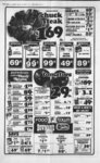
| OCR Text |
Show mm 'i'm,0'0lr' 'pitftn i r- - , ! , rr ,B x, JJ t 4 DAVIS COUNTY CLIPPER, JANUARY 24, 1 979 WEEKLY REFLEX DELINQUENT PROPERTY TAX LIST OF DAVIS COUNTY FOR THE YEAR 1978 Under the direction of the Board of County Commissioners of Davis County, State of Utah, I hereby give notice that the following named persons are delinquent in the payment of the 1978 State School, State Special District and City Property Taxes upon the property described and in the amount indicated. Unless said delinquent taxes, together with' penalty and advertising costs are paid before 12 oclock noon on the 8th day of February 1 979 the real property upon which such taxes are a lien, excepting only such property as is held by the County under a prior preliminary tax sale, will be sold to Davis County, State of Utah, for taxes, penalty and costs of said sale. Dated this 29th day of December, 1 978. ROBERT W. TELFORD Treasurer of Davis County State of Utah NORTH SALT LAKE G. & Lloyd Mary Jane Bush, Serial No. All of lot 1, Wiggins Sub, Sec 2, Tp IN Rg 1W, SLM, Cont .16 Acres. Total Tax $35.42 Scott & Lhama L. Howey, Serial No. Beg on E In Co. Road &N In Cert 60 ft St at pt 30 05.2 feet W & 1335.7 ft N alg f J co road ft S', cor Sec 1, Tp IN, Rg 1W, SLM: N 003 W 84.5 feet alg sd co road, N 8906 E 120 feet, S 003 E 84.5 feet to N In St, S 8906 W 120 feet to beg. Cont .233 Acres. Total Tax .... $464.14 Della Z. Mottin, etal, Serial No. , Beg on N In 60 ft st at point 3005.2 feet W & 1335.7 ft N alg Co Road & N 8906 E 420 feet fr S4 cor Sec 1, Tp IN, Rg 1W, SLM, N 003 W 169 feet, N 8906 E 75 feet, S 003 East 163.3 feet to N In st, th alg st following arc of circle having 50 ft radius 85.1 ft m or to beg. cont. .285 Acres. Total Tax $300.44 Zions Securities Corporation, Serial No. Beg on the Wly line of DRGWRR at a point 1( 0.38 feet N & 1580.7 f m or 1, W of the NE'4 Sec 2, TlN-RlSLM: Th W 33.45 feet; th N 901 E 349.05 feet para to & 33 ft perp dist Wly fr W line of Sd RR RW; th E 33.45 Jc to"W line of sd RW; th S 9o01 W 349.05 ft alg sd rw to pob. cont .26 Acre. Total Tax $7.87 Carl Feller, etal, Serial No. NSL-124.26 Com chs, W fr NE cor of Sec 2, Tp IN, Rg SLM S alg st 13.29 chs, W 1W, 3.84 chs to E line of rw OSLRR Co. NE alg E line of RR 13.50 chs to N line sd section to pt directly W of pt of beg. E on section line 1 ch to beg. cont. Less street. 2.57 Acres. Total Tax ... . $668.53 D. Bar. E. Stables, Inc, Serial No. Beg on W In of state road 2.43 chs N & 762 ft W fr SE cpr NEW Sec 2; T1N-R1SLM: the SEly alg sd W In 503.8 ft, W 94 feet, m or 1, to RR RW In, N 857 E 534 feet, E 185 feet, m or 1, to st road prop In, thS 34 15 W 125 feet, m or 1, E 55 ft, m or 1, to beg, cont 2.00 acres. Total Tax $285.51 Zion Securities Corporation, Serial No. Beg in cen sec 2, T1N-R1SLM; th S 264 feet; th E 548.37 feet m or 1, to W In ppty conv in th N 63838 W 417.25 ft, m.or 1, to a point 2.43 chs N of S m of NEW sd Sec 2, th N 8928 W 498.94 ft, m or 1, to a point 2.43 chs N of cen sd Sec 2; th S 2.43 chs to pob, cont 5.10 Acres. Total Tax NSL-102-- NS1-10- NSL-115- 1 ft; th N 6812 W 66 ft, mol, to W In of said old BERR RW; th S 3117 W 151.98 ft, mol, alg W In of sd RW to a point N 6812 W fr pob; th S 6812 E 66 ft, mol, to pob. cont .23 Acres. Total Tax $29.10 C. Scott & Joyce T. Hansen, Serial No. NSL-1Beg at pt 1392.7 feet N 2070.2 feet W, N feet SW cor of 263 E fr 2148 Sec 1, TlN-RlSLM. S 2148 W 113 feet, N 68 12 W 162.68 ft, N 3126 E 114.62 ft, 5 6812 E 143.5 ft cont .40 acres. Total Tax $745.60 Roger E. & Debra J. Kimber, Serial No. NSL-1Beg 3005.5 ft W & 1570.7 feet N fr SW cor Sec 1, TlN-RlSLM: th N 74 ft; th E 114.87 ft; th S 74 ft; th W 114.87 ft to pob. Cont .195 Acres. Total Tax 8, $322.47 Paul J. & Diane Quintana, Serial No. All of Lot 108, Garden Grove No. 2, Sec ; SLM: Cont. .195 Acres. Total Tax NSL-19-10- 8, TlN-RlW- NSL-124-- NSL-128-- NSL-136-1- 396-16- David R. & Deanna Williams, Serial No. Beg at a point 2688.2 ft E of WW cor of Sec 4, TlN-RlSLM: th N 188.8 ft; th E 1271.8 feet; thN 1131.2 feet; thW1320ft; th S 74.5 feet; th S 7325 W 392.7 ft; mol, alg S bank of an old irrig ditch to old E Meander In of Jordan River, th alg sd meander In S 12 W 402 feet, mol; th S 25 E 759 ft; th S 55 W 165 ft; th S 110 ft, mol, th N 8553 E 264 feet, mol, th N 2642 E 155.1 ft to pob. cont 44.47 Acres together with water rights. Total Tax $350.00 Zion Securities Corp, Serial No. NSL-136-8Beg on E line of St Hy at pt N 8951 30 E alg sec line 91.0 ft fr SW cor Sec SLM: th N 35; T2N-R1895130 E 2499.6 ft to fence line; th N alg fence In 126.1 ft to fence comer; th S 8951 W alg fence line 2499.6 feet, m or to E line of st hy; th S alg sd E line 125.8 feet, m or 1, to pob. cont 7.23 acres less to Albert- sons C. Phill & Delores McKowen, Serial No. NSL-20- , Beg 3005.5 feet W 6 1504.7 ft N fr SW cor of Sec 1, Tp IN, Rg 1W, SLM: N 003 W 66 feet; N 8906 E 660.0 feet; S 003 E 66 ft; S 8906 W 660.0 feet to beg. Cont. 1.00 Ac. Total Tax $335.15 Arlene M. Bradshaw, Serial No. NSL-22Beg on E In of Hiway 250 feet S 2133 W fr inter of E In sd Hy & S In of Co. rd, which pt is 108.5 ft, m or 1, E & S 2133 W 269.9 ft, m or 1 fr NW cor Sec 12, Tp IN, Rg 1W, SLM, S 2133, W 750 feet, th SEly alright angles to sd hy 135 ft, m or 1, to cent In of Bonneville Irrig Canal, th NEly alg sd cen In 760 ft, m or L to pt SEly at right angles to sd Hiway fr beg. th NWly 190 ft, m or 1, to beg, cont. 3.00 Acres. Total Tax .. $1,065.71 Bill J. & Colleene M. Tulin, Serial No. All of Lot 51, Orchard Hills Plat D Sec SLM: Cont. 12; TlN-Rl.16 Acres. Total Tax . $468.24 Henley H. & Linnie H. Blevins, Serial No. NSL-22Com on N side of 33 ft st known as Val Verda Rd at pt 877.75 ft S 205.08 ft E on NW cor of Sec 12, TIN, RlW, SLM; N 4332 E 100 ft, N 4628 W 290.22 ft, S 20 W 106.3 ft, S 4628 E 254 ft to beg. This is also lot 6, Cont. .62 Acres. Total Tax 1, 4; $160.44 1, $364.93 3.21 Ac. Remainder 4.02 Acre. Total Tax $126.64 & H. Transportation Co. Inc, Serial No. Beg at a point 1 ft W & 2 ft N or SE cor of Lot 2, Blk 27, North Salt Lake Plat B & run th E 190 ft; th S 60 ft; th W 190 ft; th N 60 ft to pob. Cont .26 Acres. Total Tax 545-44- 8 $7 87 E. O. Muir & Co. Inc, etai, Serial No. Lots 38 to 43, ini I Blk 37, North Salt Lake addn plat B, Sec 3, T1N-R1- SLM; cont .45 Acre. Total Tax $42.47 E. O. Muir & Co. Inc, etal, Serial No. Lots 1 to 4, inc. Lots 7 to 20, incl lots 25 to 33, incl. lots 36, 37, 42, 45, 47, 48, all in blk 38, North Salt Lake Addn Plat B, Sec 3, T1N-R1SLM cont. 2.475 Acres. Total Tax $77.86 W. R. & Dolores H. Burnham, All etal, Serial No. NSL-15-of Lot 1, Castle Sub. Sec 1, T1N-R1SLM: Cont. .205 Acres. Total Tax $581.22 David Lee & Patricia L. Soper, Serial No. NSL-15-All of Lot 8, Castle Sub. Sec 1, TIN-RlW- ; SLM: cont. .175 Acres. Total Tax $415.27 .... Mary Ouzounian, Serial No. NSL-1Beg 1392.7 ft N 2070.2 feet W fr SW cor of Sec 1, TlN-RlSLM, N 2148 E 150 ft, N 6812 W 162.68 feet, 5 3126 W 151.38 ft, S 6812, E 187 feet to beg cont. .60 Acres. Total Tax .... $329.54 A. Ouzounian, Serial No. NSL-17-Beg on E In of former rw of old BERR & at SW cor of grantees exist premises at a point 1392.7 ft N 6 2070.2 feet W to W In of a st Hy & N 6812' W 187 ft fr SW cor of Sec 1, TlN-RlSLM; & run th alg sd E In of old BERR RW N 3126 E 151.98 tal Tax $396.83 Elizabeth E. M. Swenson, Serial No. Lot 108, NSL-251-10- Hillside Gardens, Sec 12, Tp IN, Rg 1W, SLM, Cont 203 Acres. Total Tax $97.38 Rodney R & Karen O. Walker, NSL-251-6Serial No. Lot. 62, Hillside Gardens, Sec 12, Tp IN, Rg 1W, SLM, Cont .21 Acres. Total Tax $414.29 L. W. & Elizabeth E. Sorenson, Serial No. NSL-251-7Lot 74, Hillside Gardens, Sec 12, Tp IN, Rg 1W, SLM, Cont .23 Acres. Total Tax $533.16 Gus Weiser, Serial No. NSL-27E 417 at Beg ft, S 30 W pt 24.7 ft fr NW cor of NE of Sec 14, Tp IN, Rg 1W, SLM, S 30 W alg E RW OSL RY, ft, E 81.8 ft to B RY RW N 6 36, E alg sd RW 1388.6 ft, W 167.4 ft to beg. cont 2.92 Acres. Total Tax 1381.4 $92.02 G. Kirk Serial No. Reg 91 ft E & 112 ft N, th E 780 ft; th S 112 ft; th E 732.8 ft; th N 433 W 598.8 ft; th N 8948 E 1419.2 ft thence E 1370.72 ft, m or 1, to' Graff, RW In of D&RGW RR: th N 919 E 289.3 ft alg sd Wly RW In fr SW cor of sec SLM: th S 35; T2N-R18935 E 508.5 ft; th N 33 feet; th E 89.1 ft; th N 182.2 ft; th W 503 feet, m or L to sd Wly RW In; th SWly alg sd RW In to pob. Cont 2.64 Acres. Total Tax $158.10 Dorothy May Howard, Serial No. Beg about 3.26 chs W & 820 chs N of SE cor T2N-R1Sec 35, SLM, W 15.84 chs th alg Western bndry of ppty in Sly direction 7.86 chs, th E to W side of D&RG RR RW; th in Nly direction 342.22 ft alg sd RW; th E to a pt 175 ft S fr beg; th N 175 ft to beg, cont. 6.00 acres. Total Tax $251.68 Joseph J. Shool, Serial No. Beg at a point S 276 121 rods S fr NE cor sec T2N-R1SLM: th W 34; 1056 ft; th S 10 ft; th E 1056 ft; 10 N ft to pob. Cont .245 th Acres. Also beg 276 121 rods S & 1576.25 ft W fr NE cor Sec 34; th W 520.25 ft; th S 10 ft; th E 520.25 ft; th N 10 ft to pob. Cont. .12 Acres. Total .365 Acres. Total Tax . $11.80 James D. & Dorothy I. Croft, Serial No. Beg 4747.286 ft S fr NE cor Sec 34, T2N-R1SLM: th S 192 ft; W 1056 ft; N 192 ft; th E 1056 ft to beg, cont. 4.64 acres. Total Tax $2,298.95 Ray H. & Glen Willesen, TrustNo. ees, Serial Beg 276 121 rods & 434.5 ft S & 20965 feet W & S 376.5 ft fr NE cor sec 34; T2N-R1SLM: th E 520.25 ft; th S 10 feet; th W 1040.5 ft; th N 10 ft; th E 520.25 feet to pob. Cont. 24 Acres. Total Tax . . . $7.08 Edwin L. & Nona C. Brower, Serial No. Beg 276 121 rds & 384.5 ft S & 3657.25 feet W fr NE cor Sec SLM W 520.25 34, T2N-R1feet; N 374.5 ft; E 520.25 ft; th S 374.5 feet to beg, cont. 4.48 Acres. Total Tax $140.78 Irma Van Tassell, Serial No. 276 121 rds Beg S fr NE cor Sec 34; T2N-R1SLM: th S 015 W 192.5 ft; th W 1056 ft; th N 015 W 192.5 ft; th E 1056 ft to the pob. Cont. 4.45 Acres except the N 10 ft thereof. Total Tax $787.39 Bemetha Bland, Serial No. Beg 276 121 rods S & 1056 ft W fr NE cor sec 34; T2N-R1SLM: Th S 384.5 ft; th W 520.25 ft; th N 384.5 ft; th E 520.25 ft to pob, cont. 4.60 acres. Total Tax Wly NSL-282-6- $243.45 Arlene M. Bradshaw, Serial No. Beg on E In of Hy 91, sd pt being N 8956 E 103.98 ft alg sec In & S 2152 W 239.89 ft fr NW cor Sec 12; TIN RlW; SLM: th S 2152 W 30.01 ft; th S 6808 E 19526 ft to Wly In of Reddi Spud ppty; th N 2259 E 2.49 ft; th N 2133 E 27.52 ft; th N 6808 W 195.15 ft to pob. cont. .135 Acres. Total Tax . $12.99 David T. & Janet E. Zeiter, Serial No. Beg at NE cor of lot 11, Orchard Hills East, Plat 1, Sec 12, TlN-RlSLM: run th S 11603 E 95 ft; th S 8843 57 W 110 ft to E ln of a st; th N 1 1603 ' W 75 ft alg sd st; th Nly 31.42 ft alg arc of a 20 ft rad curve to right alg sd st; th N 884357 E 90 ft alg S In of st to pt of beg, being all of said lot 11 & 5 ft of lot 74 in Orchard East, Plat 11, Cont .23 Acres. Total Tax .... $832.12 MCK Const. Inc., Serial All of lot 120, Orchard Hills East, Plat 11, Sec 12, ; SLM:. cont .16 Acres. Total Tax NSL-22-8-- S TlN-RlW- $182.47 Gerald B. & Janet C. Johnson, Serial No. AU of Lot 21, Orchard Hills East Plat 1 Sec 12, TlN-Rl- SLM: Cont. .21 Acres. Total Tax $576.51 Gregerson Homes, Serial No. All of Lot 85, Orchard Hills East, Plat 11, Sec 12; ; SLM: Cont 20 Acres. Total Tax TlN-RlW- $448.31 David B. & Angela P. Holbrook, All Serial No. ' of Lot 100, Lakeview Estates, Sec 12; TlN-RlW- ; SLM: Cont. .28 Acres. Total Tax $301.24 Paul M. & Robyn Taylor, Serial No. All of Lot ; 107, Lakeview Estates, .21 Acres. Total Tax $584.38 David B. & Angela P. Holbrook, Serial No. All of lot 30, Lakeview Estates. Cont. .66 Acre. Total Tax $33 82 David' B. & Angela P. Holbrook, Serial No. All of Lot 33, Lakeview Estates. Cont. 20 Acre. Total Tax $133.71 Roger W. & Kay N. Stowell, All Serial No. of Lot 60, Lakeview Estates, Sec 12; TlN-RlW- ; SLM: Cont 21 Acres. Total Tax $600.11 David B. & Angela P. Holbrook, All Serial No. of Lot 65, Lakeview Estates, Sec 12; TlN-RlW- ; SLM: Cont. .20 Acres. Total Tax $133.71 David B. & Angela P. Holbrook, All of Serial No. Lot 7, Lakeview Estates, Sec SLM: Cont. 12, TlN-RlW- ; 26 Acres. Total Tax . $141.57 David B. & Angela P. Holbrook, All of Serial No. Lot 8, Lakeview Estates, Sec SLM: Cont. 12, TlN-RlW- ; .35 Acres. Total Tax . $152.58 L N. & Flora Case, Serial No. Lot 106, Hillside Gardens, Sec 12, Tp IN, Rg 1W, SLM, Cont .19 Acres. To $144.71 Joseph J. Shool, Serial No. Beg 276 121 rods NSL-282-6- 5 & 2616.55 ft W fr NE cor Sec 34. T2N-R1SLM: Th W 2591.45 ft; S 10 ft; E 2591.45 ft; th N 10 ft to beg, cont. 9 Acre. Total Tax- $17.30 Joseph J. Shool, Serial No. Beg 276 1 21 rods 6 811 ft S & 2616.75 ft W fr NE cor Sec 34, T2N-RW, SLM : S 11.2 ft; W 1040.5 ft; N 11.2 feet; th E 1040.5 ft to beg, cont. .26 Acre. Total Tax NSL-282-6- 1 $24.39 Frank L. & Afton A. Branch, Etal, Serial No. Beg 276 121 rods & 626.5 feet S fr NE cor Sec 34; T2N-R1SLM: ThS 194.5 ft; th W 1056 ft; th N 194.5 feet; th E 1056 ft to pob. Cont 4.72 Acres. Total Tax $579.65 Isaac Lee, Serial No. Beg on S In of 4 rd st, 861.3 feet S & 1444.8 feet E fr NW cor of SW of Sec 36; T2N-R1SLM: Th S 685.74 ft, mol to N In of land conv in th E 146.82 ft, mol, alg sd S In; thence N 685.74 ft, mol, to S In of st; th W 146.82 ft alg said S In to the pob. Cont 2.31 Acres. Total Tax $704.71 Brent B & LeeAnn S. Cleverly, Serial No. Lot 9, Moss Sub. Amended, Sec 36, Tp 2N, Rg 1W, SLM. Cont .15 Acres. Total Tax .... $287.86 Heber S. & Melissa Jo Meeks, NSL-282-6- NSL-295-- 201-25- NSL-336-- Serial No. NSL-336-- Beg at a point 11.22 chs N fr SE cor of SW Sec 36; T2N-R1SLM: th W alg an existing fence In 37.5 feet mol to a fence; th Nly alg fence 83 ft mol to a fence; th East alg fence 33 ft mol to a fence; th N alg fence 83.29 ft mol to S In of a road; th SE'ly alg arc of a 65 ft rad curve 33.9 ft mol to a fence th S 013 E alg fence In 159.35 ft mol to a fence; th S' 8938 W alg fence In 31.5 ft mol to pob. Cont .195 acres. Total Tax $130.56 Vem R Farr, Serial No. NSL-34Beg 12.482 chs N fr the SE cor of SW sec 36; T2N-R1SLM: th N 1.262 chs alg E In of sd SW' to S In of st; th W 178.5 ft to E In of Hy; th S 003' E 1.263 chs alg E line sd hy; th East 178.5 feet to pob. cont .35 Acres. Total Tax $1,342.56 G. W. Investment, Serial No. NSL-341-Beg at NE cor Lot 7, amended Moss Sub Sec 36; T2N-R1SLM: th N 2644 E 158.59 ft; th S 8938 W 345.31 ft; th SW 158.59 ft, m or 1, to point on N line of Moss Amended Sub; at pt 345.31 ft W of pob; th N 8938 E 345.31 feet to pob. Cont. 1.253 Acres. Total Tax $799.87 G. W. Investment, Serial No. NSL-341-Beg at point on N line of amended Moss Sub Sec SLM: th N 36; T2N-R18938 E 16.50 feet fr NW cor lot 1, sd sub; which pt is also N 1048.16 feet & E 32.58 feet fr SW cor Sec 36; th N 8938 E 295.03 ft alg N line sd sub to SW cor ppty conv in 402-28th NE 158.59 feet, m or 1 to a point N 2644' E 158.59 ft & S 8938 W 345.31 feet fr NE cor lot 7, sd Sub thence S 8938' W 200 feet; th S 25.0 feet; th 8110 45 W 168.43 feet; th S 003 E 91.42 feet to pob. Cont 31 Acres. Total Tax . $152.58 Wayne F. & Wilma G. Parkin, Beg N Serial No. alg W In of 009 W 1320 feet T2N-R1VSEW of Sec 36; SLM: Th N 8956 E 203 ft & S 040 W 123 ft & N 8940& EE 365.51 feet & N 415.58 feet 20.06 feet fr SW cor of Sec 36, sd pt being on E'ly In of a st th a Nly 93.05 feet alg arc of sd 233.13 ft rad cur to left alg Ely In; th N 1554 W 50 ft to N Sly In of a st road; thence In 7406 E 242.04 ft alg sd Sly to a point on a 583.62 ft rad cur to right; th alg sd cur for an arc dist of 163.82 ft, sd pt is N 8952 W 413.25 ft and S 008 W 53 feet fr a Davis Co. Monu at the cen In of 2600 S & Main St; th S 8952 E 67.25 feet; th 5 301205 E 49.49 ft to Wly In of Bamberger RW; th S 261845 W 206.90 ft alg sd pob. RW; th W 373.58 feet toTax Cont 2.066 Acres. Total $2,836.91 . . NSL-345-- Sly NSL-345C-- 506-85- 9 $984.70 Zions Securities Corporation, Serial No. NSL-35Beg at a point N 11826 W 356.6 feet &S8950E 324.02 ft fr SW cor SLM: ; Sec 2; Thence N 911 E 948.36 ft; thence S 8049 E 56 feet; th S 911 W 213.89 feet; th S 7448 E 33.27 feet; th S 905 30 W 66.0 feet; th N 793850 W 13.72 feet th S 74840 W 76.57 feet; thence N 7942 30 W 34.74 ft; th S 910 W 580.85 feet; th N 8950 W 43.56 feet, m or I to pob cont. 1.165 acre. Total $36.97 Tax Zions Securities Corporation, Serial No. NSL-35Beg on Wly RW line of D&RW RR at a point N 11826 W 356.6 feet & South 8950 E 692.77 feet & N 901 E 1920.83 feet fr SW cor Sec 2; TlN-RlSLM: thence N 8327 20 W 145.2 feet; th N 901 E 112.41 feet; th S 825400 E 145.20 feet; th S 901 W 118.66 feet to pob. Cont .383 acres. Total $174.60 Tax Zions Securities Corporation, Serial No. NSL-35Beg at SLM: cen Sec 2; TlN-Rlthence S 8925 50 W 1204.97 TlN-RlW- 3, N 12.2 feet; th S W alg a fence line 1331.87 feet, m or 1, to E line of a Hy, th E 2610.33 feet, m or I, to pob, cont .596. Total Tax feet; th 884648 Zions Securities NSL-356-- 894955 TlN-Rl- 382-40- NSL-42-1- In of st rd of (Proposed 2600 S St. Proj No. NS 129 (1) at a pt S 8950 W 831.11 feet 6 S 009 E 149.40 ft & S 7406 W 25 ft fr a Davis Co. Monu mark the cen In inter of 2600 S. & Hy 91, run th S 74 06 W 7.26 ft; th S 1554 W 35 ft; th 5 7406 W 3.82 feet; th S 008 E 216.51 feet; th S 8951 West 684 feet; thence S 009 E 15 ft; th North 8951 E 19.34 feet to a pt S 8950 W 831.11 feet & S 009 E 424.59 ft & S 8951 W 12.5 ft fr sd Davis Co. Monu; th S 009 E 273.43 ft; th N 8940 E 12.50 feet; th N 009 W 496.56 feet to Sly end of a 40 ft access opening; th S 7406 W 10.63 feet; th N 1554 W 50 ft to pob. Cont. .221 Acres. Total $51.91 Tax Jim P. Mola & Merton S. Anderson, Serial No. Beg at a point S 8950 W 831.11 feet & S 0 09 E 439.59 feet & S 8951 W 31.84 feet fr a Davis Co. Monu mark Intersec of Cen In of Hy 91 & 2600 S. St, fr wh a monu in cen In pt of intersec of sd 2600 S st 6 500 W bears N 8950 E & run th S 8951 W 158.16 feet; th N 009 W 240.61 ft, mol, to a point on a 689.62 ft rad cur to left & the S In of 2600 S St; th Ely alg arc of sd cur 90.45 ft; th North 7406 E 72.43 feet mol, to Wly In of a platted rd, American Plaza; thence S 1554 E 35 ft; th S 7406 W 72.43 ft to a point on a 724.62 ft rad cur to rt; th Wly alg arc of sd curve 84.92 ft; th S 009 E 174.29 ft; thence N 8951 E 143220 ft; th S 30 ft mol, to pob. Cont. .308 Acres. Total $72.36 Tax Zions Securities Corp., Serial No. NSL-35Beg on S In Sec 2, 623.67 ft E fr SW cor Sec 2, Tp IN, Rg 1W, SLM, West alg S In sec. 269.9 ft, N 4903 W 544.1 ft, E 2583.42 ft, S 356.6 ft . to point on Sin Sec 2, W along S 1 sec to beg. Cont. 19.016 Acres. Total Tax . . $1,794.79 i Zion Securities Corp., Serial No. NSL-35Beg 356.6 feet N & 29.03 feet W fr SW cor Sec 2; TlN-RlSLM: th S 8950' E 1666.28 feet; m or L para to 8 ' line sd sec 2 to a N l1826n V ' W 356.72 ft & Wlypt101 1.39 feet para to sd sec line fr SW cor sd ' Sec 2; thence N 12834 W E 1999 ft; th S 8195810 756.12 feet; th S 74 3910 E 378.71 ft; th S 46T7T0 E 398.19 ft; th S 343110 E 94.12 feet; th S 155810 E 277.41 feet; thence S 454 50 W 281.68 ft; th S 8049 E 89 ft; th N 911 E 91.82 feet; th N 505 10 E 151.62 feet, th N 40810 W 181.72 feet; th N 17 2030 W 221.04 feet: th N 63838 W 431.9 ft mol to a point 264 feet S of N In of SEW Sec 2; thence W 548.37 feet a point 264 ft S of cen sd sec 2; thence N 264 feet to cen of sd 'Sec 2; th W 2610.3 feet mol, alg E & W cen In sd Sec 2 to the E In of Hy; thence S 0 39 E 86.44 ft alg sd Hy; th Sly 2021.15 feet mol alg sd Hy alg arc of 5779.65 ft rad curve to right to a point N 4903 W of pob. th S 4903 E to pob. Anless 10 NSL Ind nex Park. Cont 35.00 Acres. Total Tax $1,101.10 Zions Securities Corp., Serial No. All of lot 14D, AM. NSL Ind. Park Plat A. Sec 2; TlN-RlSLM: Cont 1.267 Acres. Total Tax Beg on at a point ppty conv in 2390.86 feet E of the SW cor of Sec 2; TlN-RlSLM: thence N 9o10 E 360.89 feet; th W 483.60 feet; th S 356.6 feet; thence E 400.49 feet mol to pob. Cont 3.47 Acres. Total Tax $327.19 Dennis M Peck, Etal Serial No. NSL-36Beg 1240 feet W & S 04030 E 257.55 feet fr the NE cor of SEW of Sec 3, TlN-RlSLM: run th S04030 E 37.36 feet to the North line of ppty conveyed to Mineral Fertilizer Co. by WD 346-2th S 884430 E 1164.72 feet alg sd N line to the Wly line of a hy; th Nly 73.74 feet alg the arc of a 5679.65 ft rad curve to the left alg said hy to the S line of ppty conv to Zions Securities Corp. by WO th N 871030 W 125.22 ft mol th to 580.50 ft W South 895130 a point of a 745.30 ft rad cur to the right; th Wly 21.46 ft alg the arc of sd cur; th S 8431 W 165.02 ft; th W 275.45 ft to pob. Cont 1.82 Acres. Total Tax $57.42 Alan C. & Susan J. Cutler, Serial No. All of Lot 19, ; Wilson, Sec 1, SLM: Cont .16 Acres. Total Tax $456.17 Thomas J. & Deborah L. Lewis, All of Serial No. Lot 26, Wilson. Sec 1, TlN-Rl664-88- 6 Lincoln Land Management Corp., Serial No. Page 25, 1979 DAVIS NEWS JOURNAL, JANUARY $18.10 Corp., Serial No. Beg at a point S E alg S In of Sec 2, SLM: a dist of 257.94 ft & N 911 E 360.84 ft fr SW cor of sd Sec 2 & wh point was prev desc as& NS 11826 W 356.60 feet 8950 E 324.02 feet fr sd SW cor; & run th N 8950 W 1335.35 feet; th N 12834 W 1999 feet; th S 895810 E 756.12 feet; th S 743910 E 378.71 feet; th S 4617T0 E 398.19 feet; thence S 343110 E 96.12 feet; th S 155810 E 180.04 feet; th N 8950 W 506.02 feet! th S 259 W 816.77 feet; th South 8950 E 513.21 feet; th S 9011 W 566.53 feet to pob. Cont 54 24 acres. Total Tax . . . $1,706.71 Zions Securities Corp., Serial No. NSL-35Beg at SW comer of TlN-RlW- NSL-42-2- Cont SLM: .16 Acres. $437.30 Total Tax Edward C. Jensen, Serial No. NSL-42Beg on E In of US Hy 91, at point N 89 52 W 2542.7 feet & N 2152 E 645.5 feet fr SW cor of Sec 1, TlN-RlSLM: & thence S 6943 E 236.1 ft; th S 2152 W 66 feet; thence S 6943 E 110 ft, mol to E In of sellers land; th alg sd E In N 2246 East 131 ft; th North 6943 W 347.2 feet to sd E In of Hy; th along sd E In S 2152 W 65 ft to pob. Cont .66 Acres. Total Tax $249.14 Ralph K. & Robyn C. Thompson, Lot 47, Serial No. Paul Sub, Amended, Sec 1, Tp IN, Rg 1W, SLM, Cont. .175 Acre. Total Tax $433.37 Herbert N.& Suzanne J. HenderBeg son, Serial No. NSL-43on Wly In of Ballard Acres Sub at point N 8952 W 2542.7 feet & N 2152 E 1981.3 feet to bndy In of sd ppty, as created by bndy agmt between the adj ppty owners & as sd bndy is indicated by an exist fen In & alg the E In of a Hy & S 6955 E 409.45 ft, mol, fr SE cor of SWW of Sec 1, TlN-RlSLM: th N 69 55 W 130 feet to W In grantees land; N 20 0130 E 108 ft; th N 6955 W 102.38 feet, mol, to a point 183.85 feet S 6955 E of E in of sd hy; thence N 1956 E 114.50 ft; th S 6955 E 220.85 ft, mol to cen In of old Bonneville Irr Dist Canal RW; Nly alg cen In 74 ft to a point 11.3 feet W fr E In of WW of SWW sd sec 1; th S 014 E 196.63 ft mol alg sd Ln to n In of Ballard Acres Sub; thenceS 8036 W 70 ft mol to NW comer sd sub; th S 200130 W 76 ft mol to pob. Cont. 1.003 acres. Total Tax $97.38 Alfred G.& Barbara Reeve Gunn, Serial No. NSL-43Beg at inter of Sly ln of 7200 S. (3800 - So.) & Ely ln of Hy 91 at pt 2359.37 feet N & 1596.43 feet NSL-43-4- 8, W fr SW cor Sec' 1; TlN-RlSLM: thence N8938E 100 ft S ln sd st; th S 2019 W V alg 184.78 ft; thence N 6955 W 100 ft to Ely line sd hy; thence N 2152 E alg sd Ely ln 31.75 feet; th NEly alg a 15624 cur alg sd Ely ln 1 18.27 feet to pob. Cont 0.384 Acres. Total Tax $1,660.33 James W. & Edith M. Hitchens, NSL-43Serial No. Beg on E ln of Hy & SW corner of Sellens land at pt N 8952 W 2542.7 feet & N 21 52 E 1981.3 feet fr SW cor Sec 1; TlN-RlSLM: thence alg Sly ln of sellers land S 6955 E 275.32 ft m or 1, to land heretofore conv to S Arthur thence alg sd Gregerson; Gregerson Land N 200130 E 108 ft, m or 1, to Nly In of sellers land; th alg sd Nly line N 6055 W 267 ft m or 1, to E ln sd Hy; thence S 2152 W 108 feet m or 1, alg sd hy to pob. Cont. .68 Acres. Total $126.60 Tax Gary R & Sherry L De Marco, AU of Serial No. NSL-44-1Lot 16, Cobble Creek East; SLM: Cont. Sec 1; TlN-Rl.17 Acre. Total Tax . . $446.73 Henry L. & Ruby O. Veylupek, All of Serial No. NSL-44-1- Creek East; SLM: Cont. 21 Acre. Total Tax . . $515.95 Parley S. & Nellie C. Campbell, Serial No. NSL-44-Beg 1603.2 feet S & 643.2 feet E fr NE comer Sec 2, TlN-RlSLM, E 85 feet N 100 feet W 85 feet thence S 100 ft to beg, cont .20 Acres. Total Tax 17, Cobble Sec 1; TlN-Rl- Lot $192.70 Lee R Nielsen, & Mel A. Rozema, Serial No. Beg 421 feet E & 1603.2 feet S fr NE Cor of Sec 2, TlN-RlSLM: Thence N 185 ft, mol, to Ely No access ln of Hy known thence SWly as proj No. alg sd No access ln to a point on Nly RW ln of 7050 S St in No Salt Lake; th E 105 feet, mol to pob. Cont. .24 Acres. $520.66 Total Tax R G. Apgood, Etal Serial No. NSL-41225.1 W & ft Beg 575.1 feet N of cen Sec 1, Tp IN, Rg 1W, SLM, N 8958 W 19.3 feet, N 3129 E 526.5 feet, E 19.3 ft, S 3129 W 526.5 feet to beg. Cont .20 Acres. Total Tax $36.18 Lindsay Otto & Suzanne F. Stens, Serial No. NSL-4Beg 1459.2 feet S& 11 feet E fr NE cor Sec 2, TlN-RlSLM; thence W 238.7 feet to center of a 4 rod st; thenceS 70 ft; E 238.7 ft; th N 70 ft to beg, cont. .38 Acre. Total Tax $297.40 Don Buehner, Etal, Serial No. NSL-46-- 01-- Beg N 026'00 1322.70 ft & S 8953 30 NSL-5- W W 979.43 ft fr SE cor Sec 1, TlN-RlSLM; S 895330 E 341.07 ft; N 32.25 ft; N 8947'00 W 187.42 ft; S 197.25 ft, m or 1, to W'ly ln of Highlands Plat A Sub; N 405740 E alg sd Wly In to NW cor Lot 21, sd sub; S 490220 E 120 ft; N 4057'40 E 104.172 ft; S 760050 E 89.767 feet to pt on a 297.30 ft rad curve to right; thence alg arc sd curve for an arc dist of 120.02 ft; th N 405740 E 146.48 ft mol to beg. Cont .75 Acres. Total Tax $11.80 Elvin J. & Patricia J. Thomsen, All of Serial No. NSL-59-Lot 9, Hillside Oaks Sub, No. 1 TlN-RlAmended; Sec 12-SLM: Cont. .31 Acres. $716.51 Total Tax Earl N. & Mignon C. King, etal, Lot 18, Highlands Plat A, Sec 1, TlN-RlSLM cont. .25 Acre. Total Tax $23.60 Mtge. Invest. Trust of Utah, Serial No. Lot 28, Highlands Plat A, Sec 21, TlN-RlSLM, Cont. .21 Acre. Total Tax $19.67 Mtge. Invest. Trust of Utah, Lot 31, Serial No. Highlands Plat A, Sec 1, TlN-RlSLM, Cont. .215 Acre. Total Tax $19.67 Mtg. Invest Trust of Utah, Serial Lot 32, No. Highlands Plat A, Sec 1, TlN-Rl.215 cont. SLM, Acre. Total Tax $19.67 Ray C. & Nellie B. Hatch, Serial 1 No. A, Beg at a point 3060.9 feet W & 747.1 ft N and N 029 W 174 ft & W 683 ft fr SW comer Sec 1, TlN-RlSLM: thence S 174 ft; th W 24.62 ft; th N 163 ft; th Ely 19.1 ft alg arc of a 45 ft rad cur to left th E 9.62 ft alg S line sd .10 Acres. Total st $9.44 Tax Ronald B. & Mary H. Watkins, Serial No. NSL-70-Beg on W ln of a St at a point W Serial No. BO Water $34.60 3am Richard & Brenda M. Edwards, Serial No. BO 344, Beg at SE comer Lot 1, Blk 38, Plat A, Btfl Ts. th W 54 ft, N 103 ft, E 70.5 ft; S 103 ft, thW 1 rod to beg cont. .165 Acre. $336.69 Total Tax E. Nordell Weeks, CO First Sec Bk of Bo., Serial No. BO 388-Beg 154 ft W fr SE cor of Lot 1, Blk 42, Plat A, N 10 rds W 110 ft, S 10 rods, E 110 ft to Beg. Cont .42 Acres. Total Tax $644.99 $40.90 BO Water Francis Joseph Jr. Tomey, Serial No. BO 430, Beg 100.5 ft S of NW cor of Lot 3, Blk 45, Plat A, E 115.5 feet, S 4 rds, W 115.5 feet, N 4 rds to beg. cont. .175 Ac. Total Tax $265.72 William A. & Julianne P. Shanks, Serial No. BO 481, Beg at SW comer lot 2, Blk 52, Plat A, Btfl Ts. Survey; th N 111.0 ft; E 88.0 ft; th S 111.0 ft; th W 88.0 ft to beg. cont. .225 Acre. NSL-60-1- NSL-60-2- NSL-60-3- NSL-60-3- NSL-70-- Total Tax 3054.8 ft, mol & N 747.1 ft & N 029 W 103 ft alg sd st fr SW SLM: cor of Seel, TlN-Rl& run th N 029 W 71 ft alg sd st; th W 142 ft; th S 029 E 71 ft par to sd st; th E 142 feet to pob. Cont. .23 Acres. Total $502.62 Tax Dale C. & Betty H. Washburn, Serial No. NSL-70-Beg on the S ln of a street at a pt 747.1 ft N & 3060.9 ft W to the W ln of a st & N 029 W 174 ft alg sd st & W 215 ft alg the S ln of the st fr the SW cor of Sec 1; TlN-RlSLM: & run th W 60 ft alg the S ln of sd st; th S 174 feet; th E 60 ft; th N 174 ft to the pob. Cont. .24 Acres. $208.43 Total Tax Blaine H. & Emma Jean H. NelBeg son, Serial No. NSL-8on Wly ln of strd 714.12 ft N & 503.36 ft W from SE cor of NEW of Sec 2 TlN-RlW- ; SLM: thence N 3415 E alg Wly ln of sd Hy to cen ln of Mam St, of NSL th N alg sd cen ln of Howard St, 30 ft, mol, to pt 894.12 ft N of S ln of sd NEW; thence W 461 ft, mol, to E RW ln of OSL RR: Th SWly alg Ely RW ln of sd RR 181 ft, mol, to pt 714.12 ft N of S ln of sd NEW; th E 376.75 ft mol to pob. Cont 1.65 Acres. Total Tax $349.20 Robert W. Adams, Serial No. Beg on W ln of a St at a pt 978.95 ft N & 426.36 ft W of SE cor of NEW of Sec 2, TlN-Rl& run th N 65.0 ft alg the W In of Sd st; thence W 180.0 feet; th S 65.0 ft; th E 180.0 ft to the pob. Cont. .27. $988.63 Total Tax H. J. Harrison Const. Corp., All of Serial No. Lot 30, WUdwood Plat C, Sec TlN-RlSLM: Cont. .17 2; Acres. Total Tax $541.90 Jack B. & Beverly M. Wood, All of Serial No. Lot 39, Wildwood Plat C, Sec SLM: Cont. .19 2, TlN-Rl$64.49 Acres. Total Tax Jack B. & Beverly M. Wood, All of Serial No. Lot 40, Wildwood, PlatC; Also that portly. . of Lot 2 desc as beg at NE corner of Lot 2, Wildwood, Plat A & run thence W 4 ft; th S 122523 W 35.84 ft; th N 1830 E - " 36.905 feet to pob; but except fr lot 40 that portion desc as beg at SE cor of Lot 2, Wild- Tax BO Water McGlynn-Garmak- NSL-93-3- NSL-93-4- plat A, Sec 2; TlN-Rl- $62.92 BOUNTIFUL Zions First Natl Bank, CO Frank Newman, Serial No. BO 18, Beg at NW comer of Lot 1, Blk 5, Plat A, E 66 feet, S 132 ft, W 66 ft, N 132 ft to Beg. Cont. .23 Acres. Total Tax $360.34 BO Water $32.90 Glen Spencer, Serial No. BO 59, Beg 120 ft W fr NE comer of lot 1, Blk 11, Plat A, W 30 feet, 5 15 ft, E 30 ft. North 15 ft to beg. cont. 0.01 acres. Total Tax $3.15 Keith L & Nora A. Stahle, etal. Serial No. BO 67, Beg on E line of 300 E St., N 017E 110 ft from NE cor of intersec of 300 E & 400 S Sts. at apt N E 110 ft & N 8948 W 16.5 ft fr SW cor of Lot 1, Blk 12, Plat A, Btfl Ts Sur: & run thence alg E ln of sd 300 E St, N 220 ft, mol to apt 16.5 ft W from NW cor of Lot 2, sd Blk 12, being also S ln of 300 S St th along N ln of sd Blk 12 & S ln of 300 S St. E 372 ft. mol to W line of a Hy (400 E St) thence alg sd W line, S 330 ft, mol, to N line of 400 S St; th alg N line of sd St, being also S ln of said Blk 12, W 272 ft, mol, to W ln of Grantors land; th along sd W line N 017 E 110 ft; th N 8948 W 100 ft to pob. Cont. 2.62 Acres. Total Tax 0ir $26,055.98 BO Water $132.15 & Irvin F. Joann Williams, Serial No. BO 80, Beg 4 rds East fr SW cor of Lot 2, Blk 14, Plat A, running N 4.5 rds, E 4 rds S 4.5 rds, W 4 rds to Beg. Cont. .11 Acres. Total Tax . $141.93 Mark F. Cheney, Serial No. BO 120-Beg at sur monu in center of inter of 100 W St & 2nd S St of Btfl Ts Sur; Lot 3 Blk 18, Plat A, & run th S 8948 W 376.21 ft; th S 01630 W 24.75 ft to the true pob; Thence S 01630 W 163.78 ft; th S 8948 W 17 inches; th N 017 E 163.78 ft; th N 8948 E 17 inches to true pob. Cont. 0.1 Acres. Total Tax $3.15 Jack W. & Lois T. Pickett, Serial No., BO 290, Beg on S line of Lot 4, Blk 32, Plat A Btfl Ts Sur; at apt 165 ft N of SE comer lot 1, Blk 32, sd Plat A 6 th N 47 feet mol, to SE cor of a bldg owned by Mt. States Tel & Tel Co. th West 127 ft mol alg the S face of sd bldg to apt 127 ft W of the E In of sd Lot 4; th S 47 ft mol, to the S ln of sd Lot 4; th East 127 ft alg the S In of sd lot 4 to the pob. Cont .14 Acres. Together with and subject to a rw. Total Tax $1,647.97 Fern K. Black, Serial No. BO 322, Beg at pt 1 rod E of SE cor of Lot 1, Blk 35, Plat A Btfl Ts. W 82.5 ft, N 97 ft E 82.5 ft, S 97 ft to beg. Cont .184 Acres. BO Water $29.50 Clarence Eugene & Dorothy J. Kremer, Serial No. BO 342-Beg 10 rods E of SW cor of Lot 1, Blk 37, Plat A, N 10 rds, E 70 ft., S 10 ids W 70 ft to Beg. Cont. .26 Acres $562.99 Company, Serial No. BO 502-2-Beg 237 ft S & 85 feet W fr NE cor Lot 4 Blk 54, Plat A, Btfl Ts, S 33 ft, W 96.75 ft, N 33 ft, E 96.75 ft to beg. Cont. .072 Acres. $4.73 Total Tax J. Blair & Carol D. Jones, Serial No. BO 586-Beg at a point 1830.11 ft N & 217.36 ft W of SE cor of Lot 2, Blk 3, NMC Plat, Btfl Ts Sur. & run th W 286.53 ft; th N 400.89 ft; th E 286.53 ft; th S 400.89 ft to pob. Cont 2.63 Acres. Total Tax $3,914.11 BO Water $116.65 Malcolm B. & Collette D. Whitney, Serial No. Beg at SW corner Lot 42, NSL-93-3- SLM: thence E 4 ft; th N 122523 E 35.84 feet; th S 18 3ff W 36.905 feet to pob. Cont .16 Acres. Total Tax $338.27 $31.25 Serial No. BO 579, Beg N 8954 W 25 ft & N 007 W 173.62 ft & N 8954 W 2.0 ft & N 007 W 68.48 ft fr SW cor of Btfl Gardens Apartment Homes, sd SW comer being S 007 E 652.10 ft & North 8954 W 1375.67 ft from the NE cor of Lot 6, Blk 3, NMC Plat, Btfl Ts Sur & run th N 007 W 200.49 ft; th N 8954 W 66 ft; th N 007 W 63 ft; th N 8954 W 143.87 ft; th S 0 2130 E 53.50 ft; th N 8954 W 150 ft to East ln of St; th S 02130 E along sd E ln of st. 80 ft; th S 8954 E 95 ft th S 02130 E 130 ft; th S 8954 E 263.76 ft, mol, to pob. Together with & subject to rw Cont. 1.63 Acres. Total $257.05 Tax Charles L. & Heilen S. Amott, NSL-83-- wood, $437.62 Dean R. & Clara L. Hepworth, Serial No. BO 490-Beg at a pt W 204 ft fr NE cor of Lot 4, Blk 53, Plat A, W 60 ft, S 165 ft, E 60 ft, N 165 ft to Beg. Cont. .23 Ac. Total Tax $439.19 Charles L. Amott, Serial No. BO 494, Beg 85 feet W of SE cor of Lot 1, Blk 54 Plat A, W 104.75 ft, N 60 ft, E 104.75 ft, S 60 ft, to beg. cont. .14 Acres. Total ' Kirkhaven Sub, Plat C, a sub of pt of Blk 3, Plat NMC, Btfl Ts, thence S 8954 E 61.45 feet alg th N ln of a st, th N 00T W 150 ft, N 8954 W 1.45 ft, S 4403 W 86.12 ft along the NW ln of sd lot 42, th S 007 E 88 ft to beg cont. .215 acre. Total Tax . . $363.50 BO Water $31.25 Julia E. Peterson, Serial No. BO 609, Beg at a point on S line of 3rd St. at a pt 35.2 ids S & 187.8 ft E fr NE cor of SE4 of Sec 24, 2N, IE, SLM, S 297.0 feet W 74 ft, N 297.0 ft, E along sd line of st 74 ft to pt of beg. Cont. .50 Acres. Total $223.93 Tax BO Water $43.90 Security Inv. Co., Serial No. BO 612, Beg at NE comer lot 3, Blk 3, Plat NMC, Btfl Ts. N 007 E 53 ft, S 8950 W 330 ft, 5 007 W 53 ft, N 8950 E 100.65 ft. S 007 W 3.3 rds, S 8921 E 13.9 rds, to W ln of st, N 007 E 3.5 rods to beg. Cont. .715 Acre. BO Water $52.40 Dell H. & Veloy G. Higgs, CO Packard Inc., Serial No. BO 618, Com at a pt 8.34 chs S & 913.5 feet W fr NE cor of Lot 3, Blk 3, Plat NMC, W 50 ft, N 3.49 chs to S line of street run E & W, E 50 ft, S 3.49 chs, to pt of com. cont. more or less .25 Acres. Total Tax $287.80 William A. Hoagland, etal, Trustees, Serial No. BO 619, Com at a point 8.34 chs S 963.5 ft W fr NE cor of Lot 3, Blk 3, Plat NMC, W 50 ft, N 3.49 chs, to S line of a cer st run E & W, E 50 ft, S 3.49 chs more or less to pt of com. cont. .25 Acres. Total $257.84 Tax BO Water $32.90 Robert D. & Norma Rampton, Serial No. BO 632-2-Beg on W line of st 16.42 chs S & 502.778 ft W & S 357.85 ft alg sd st fr NE cor lot 3, Blk 3, NMC Plat, Btfl Ts. S 67 ft along W ln st. N 8954 W 83.668 ft N 4001 W 87.6 ft S 89 54 E 140 ft to beg. Cont. .19 Acre. BO Water $31.25 Kevin A. & Renae J. Bodily, 634A-3, All of Serial No. BO Lot 3, Wavne Cooper Sub. Sec T2N-R1SLM: Cont. .15 19; Acres. Total Tax $495.18 Smith Feed & Garden Center, Inc., Serial No. BO 640, Beg on W In of st at pt W 39.5 ft alg center ln of Center St & N 443.75 ft along Win of 200 W St fr Btfl City Monu at the inter of Center & 200 W Sts. wh point is 653.8 ft S of NE cor of Lot 3. Blk 3, NMC Plat, Btfl Ts Sur & run th S 254.15 ft alg the W In of sd St to a pt 164.85 ft N of N line of Center St; ThW 120 ft: thN 254.15 ft to a pt due W of pob; th E 120 ft to pob. Cont. .70 Acres. Total Tax $1,541.52 Dell H. & Veloy G. Higgs, Serial No. BO 646-1- , Beg 8.34 chs S 929.38 feet W fr NE cor of Lot 3, Blk 3, NMC Plat Btfl Ts Sur &thS 282.28 ft; th W 5.25 rds to W line of Lot 3; th N 282.28 ft alg sd W ln to a pt due W of pob; th E 5.25 rods to pob. Cont. .56 Acres. Total Tax $35.48 BO Water $46.80 & E. Harriet Coats, Frank Jr. Serial No. BO 648D-3-1Lot 11, Blk 3, Lvnnhaven Sub, in Blk Plat D, 3, Plat NMC Btfl Ts. Cont. .19 Acres. Total Tax $311.46 BO Water $31.25 Edward H. Jr. & Elaine S. Francis, Serial No. BO 648D-3-1Lot 12, Blk 3, Lvnnhaven Sub., plat D, in Blk 3, Plat NMC. Btfl Ts, Cont. .21 Acres. Total Tax $309.09 Scott D. & Dana K. Jardine, Serial No. BO 648D-3-1Lot 15, Blk 3, Lvnnhaven Sub., Plat D, in Blk 3, Plat NMC, Btfl Ts Cont .18 Acres. Total Tax $404.50 6 .... BO Water 1 $29.50 - i Jane N. Page, Serial No. BO 660-Beg at point N 11.52 chs W 1017.1 ft & N 80 feet fr SE cor Lot 4, Blk 3, Plat NMC, Btfl Ts, N 80.48 ft, E 265.16 ft, S 80.48 ft, W 265.16 ft to beg. Cont .525 Acres. $637.11 Total Tax $45.55 BO Water Jerry E. & Lois E. Lara bee, Serial No. BO 660-- Beg 11.52 chs N 57336 ft W 23 ft N fr SE cor of Lot 4, Blk 3, Plat NMC, W 129.08 ft, N 85.22 ft, E 129.08 ft, S 85.22 ft to Beg. Cont. .254 Acras. Total Tax .... $108.82 Blanche H. Jensen, Serial No. BO 688-Beg at a point 6.20 chs N 8.285 chs E fr SW cor of NW of Sec 19, 2N, IE, SLM, N 4.33 chs, E 3.435 chs, S 1.25 chs, W 2.375 chs, S 3.08 chs, W I.- 06 chs to Beg. Cont. .73 $461.27 Acres. Total Tax $52.40 BO Water W. Homer, Norman W. & Amelia 690-Serial No. BO Beg on N line of a st at a point 277.2 ft W fr SE cor of Lot 1, Blk 8, NMC Plat, Btfl Ts Sur; th N 100 feet; th E 106 ft th N 117.8 feet; thW 172 ft; thS 117.8 ft; th E 48 ft; th S 100 ft; th E 18 ft to pob. Cont. .519 Acres Reserving Life Est. to Hettie J. Knight. Total Tax.. $87.52 Stephen Jr. & Susan H. Odysseus, & . All Serial No. BO of Unit 581, Building C, Meadowbrook Estates Sec. SLM: Total 19; T2N-R1$357.77 Tax Karen H. Nichols, Serial No. BO All of Unit 567, Building E, Meadowbrook Estates, Sec 19; T2N-R1SLM: Total Tax .... $346.15 BO Water $17.70 John N. & Carolyn Pappadakis, Serial No. BO 713, Com at NE cor of Lot 1, Blk 9, Plat NMC run S 7.742 rds along W side of rds to the Hy No. 1, W 20-2- 3 E line of Davis County School Districts property, N along the E side of said property ids to the ids, E pt ot com, cont. more or less 1 Acre. Total Tax . . $3,431.55 $61.50 BO Water John N. & Carolyn W. Pappadakis, Serial No. BO 715, Com at a point on W side of Hy No. 1, 7.742 rds S fr the NE cor of Lot 1, Blk 9, Plat rds to the E NMC, W 3 line of Davis County School Districts property, S 4.871 rds to the W line rds, E of Hy N 4.871 ids to the pt of com. cont. more or less .629 $318.55 Acres. Total Tax 7.742 20-2- 3 . 20-2- 20-2- 3 John Vincent & Betty Jo McDonough, CO Rellis V. Petty, Serial No. BO Lot 3, Blk 2, Chapel Sub of Blk 9, Plat NMC, Btfl Ts. Cont .21 Acres. Also beg SW cor Lot 2, Blk 2, Chapel Sub. S 7453 E alg Sly bdry of lot 2 140 ft. N 1507 E 49 ft, N 7453 W 140 ft, S 1507 W 49 ft to beg. Cont. .16 Acres. Also beg NW cor Lot 4, Blk 2, Chapel Sub, S 1507 W 65 ft, S 7453 E 40 ft, N 1507 E 65 ft, N 7453 W 40 ft to beg. Cont .06 Acres. Total Tax 726-2-- $1,260.02 A. Curtis & Renee Phipps, Serial Lot 12, Blk No. BO 2, Chapel Sub., Blk 9, Plat NMC, Btfl Ts; cont. .158 Acre. Also beg at NW cor lot 12, Blk 2, Chapel Sub; th S 107.59 ft along Wly line sd lot 12; N 8931 W 70 ft, m or 1, to Ely rw ln of old BERR; th N 150T E alg sd rw 122.08 ft to pt N 7453 W of beg; th S 7453 E 39.67 ft to beg. cont. 726-2-1- ' .17 Acre, in all .328 Acre. $37.90 BO Water Alvin J. & Lora Lee M. Noker, Lot Serial No. BO 18, Blk 3, Chapel Sub, Blk 9, NMC Plat Btfl Ts; cont. .186 Acre. Also beg on S ln of 900 N st at point N 8928 W 672.50 ft & S 015 W 337 ft fr NE cor Blk 9, NMC Plat; sd pt is also NE cor lot 18, Blk 3, Chapel Sub; Plat A; S 015 W 125 ft; S 8946 E 83 ft to SW cor lot 2, East Chapel Sub; N 0 15 E 118.18 ft alg W In sd lot 2 to S ln 900 S st; th 72.43 ft alg arc of 406. 28 ft rad curve to left; th N 8928 W 11.0 ft to beg. cont. .24 Acre, in all. .426 Acre. $426.58 Total Tax Bernice L Bingham, Serial No. 740-1BO Lot 12, East Chapel Sub., Sec 19, T2N-R1SLM; cont. .185 Acre. Total Tax $397.40 Ernest U. Webster, Serial No. BO 745-6- , Lot 6, Judge Holbrook Sub. Blk 9, Plat NMC. Con .23 Acres Total Tax . $256.26 BO Water $32.90 Reid O. & Nadine C. Nielsen, 745-2Serial No. BO Lot 25, Holbrook Sub. Blk 9 Plat NMC. except the W 5.75 ft. and inc the W 2.875 ft in Lot 24. Cont .215 Acres. BO Water $31.25 Mary M. Cox, Serial No. BO 751-1Lot 12, Ravnor Acres, Blk 10, Plat NMC Btfl Ts. Cont. .16 Acres. Total Tax $391.88 BO Water $29.50 Security Investment Co., Serial No. BO 754, Beg on E line of a st 563.046 ft N fr SW comer Blk 10, NMC Plat, Btfl Ts. Survey; N 014 E 80.454 ft along E ln sd st; th S 89 37 E 160 ft; S 014 W 80.454 ft. m or I to pt due E of beg; th W 160 ft to beg. cont. .295 Acre. Total Tax $190.03 BO Water $36.25 Max L & Maris J. Allen, Serial No. BO 762B-8- , Lot 8, North Ridge Sub., Plat B, Sec 20, Tp 2N, Rg 1W, SLM, Cont .175 Acre. Total Tax $442.35 BO Water $29.50 Gale William & Linda C. Bevans, Serial No. BO 762C-1Lot 18, North Ridge C, Blk 10, Plat NMC, Btfl Ts cont. .225 Acre. BO Water $32.90 James Alonzo & Marilyn Irvine, 765-1Serial No. BO Lot 18, LaVista Park Plat A, Blk 10, Plat NMC, Btfl Ts, cont. .17 Acre. Total Tax $385.58 BO Water $29.50 Ira H. & Anna H. Ratcliffe, Serial 767-1No. BO Lot 15, Cherry Park Sub., Blk 10, Plat NMC. Cont .2178 Acres. Total Tax $229.83 BO Water $31.25 Lynn David & Mary Lee McKee, 808-2Serial No. BO Lot 24, Chateau Park B, Blk K, Plat NMC, Btfl Ts. cont. .168 Acre. Total Tax $402.14 J.B.M. Associates, Serial No. BO 81 A, Beg at a pt S 1966.80 ft & W 175 ft from NE cor of Blk K, NMC Plat Btfl Ts Sur; th W 25 ft; th S 944 W 140.20 ft to a point on a 246.69 ft rad curve to left th alg sd curve for an arc dist of 27.21 ft; th N 944 E 155.92 ft mol to the pob. Cont. .08 Acres. Total Tax $41.00 Sigrid E & David E. Lund., CO Home Const. Corp., Serial No. BO 832. Beg 19.97 chs S t (, |