| OCR Text |
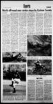
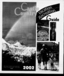
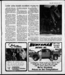
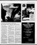
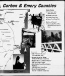
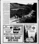
Show 4 Recreation Guide May 2002 San Rafael Swell attracts explorers, recreation enthusiasts The River San Rafael Little Grand Canthe through makes for located in a pleasant flat yon primarily region or canoe from water raft Emery County. Approximately trip by 25 miles from Price, the Swell, May to June. Two popular rough, but passarea 65 occupies an miles north to south and 40 able scenic drives include the The 900 square mile San Rafael Swell is a wild desert . oval-shap- ed Wedge OverlookBuckhorn Draw and Temple Mountain Goblin Valley roads. road The most the dramatic represents miles across. Historically, the Swell was crossed by various expeditions during the exploration of the West, but received virtually no Wedge-Buckho- m route through the SwelL At the Wedge, visitors may view the impressive Little Grand Canyon carved by the San Rafael River. The Buckhorn road drops from the Wedge through a narrow Bands tone canyon lined with cottonwoods to a crossing on the San Rafael permanent settlement The majority of the tracks crossing the Swell resulted from prospectors in the early h to century. The tracks the provided only books until 1972, when Interstate 70 was constructed. Various exits currently mid-20t- 1-- allow easy entrance to the middle section ofthe Swell and link with the mining tracks. Hiking and exploring attractions entice people to yisit the Swell. There are trails to moun- River. The Temple Mountain Goblin Valley route runs through and adjacent to the San Rafael Reef. The state park features a small valley of interesting goblin- tains, historic sites, old mines and numerous canyons to -like rock formations. Residents and travelers should consider touring the fol lowing areas (hi the San Rafael: Erosion has created unique sandd shapes in the stone on the Head of Sfobad. Deep within a canyon in the southern end of the Swell lies Hidden Splendor, once one of the biggest uranium mines buff-colore- in Utah. Muddy Creek can be followed through the San Rafael Reef when the water is low. Nearby is Keesle Country, a maze of canyons. Hondoo Arch is located above Muddy River and the area offers places for hiking as well as camping. Little Wild Horse Canyon cuts through the San Rafael Reef for two miles Near Goblin Valley State Park. Thenar row canyon makes for a good short day hike. Black Dragon Canyon has interesting pictographs. The rock are includes a dragon, geometric shapes and human figures. The panels are located about 14 miles west of Green River on a dirt road off Interstate 70. Take the dirt road north of marker 145 for one mile and mile up a turn left one-ha- lf stream bed to the canyon mouth. The pictographs are mile up the canyon. There is also impressive rock one-four- th art along Buckhorn Draw. The San Rafael Swell desert is uncompromising in summer, with little cover and temperatures routine exceeding 100 degree. Spring and fall are better options, with more moder-at-e temperatures. Pew people visit during the cold winter months. In addition to hikers and photographers, the red rock wonderland of the San Rafael Swell is a popular destination vehicle users. for d of high watei; times During rubber rafts and inner tubes carry adventurers along the San Rafael and Dirty Devil rivoff-roa- ers. provide interesting riding for vehicle enthusiasts. The undeveloped dwiw exit may be readied from 97. Drive south for &2 miles to a junction, then go right 2.1 miles to another junction. At the second junction, go right L5 miles to the dunes. Accessible from Utah Highway 24 on unpaved roads,- the San Rafael is relatively flat A off-highw-ay 1-- - main dirt road heads Bouth into the desert from the town of Graen Riven Several spurs lead from tlmmain roadto overlooks for Labyrinth Canyon. Temple Mountain is the highest point along the San Rafael Reef Visitors may reach Drive Highthe area from way 24 south, proceed light at the Goblin Valley turnoff and take the narrow paved road 6.4 miles west to the end of the 0. The United Stales Bureau of Management controls the majority of the SwelL camping is allowed ' without permits. But camping near the Wedge Overlook is restricted to designated areas. Motorized travel is limited or prohibited in certain areas to protect sensitive resource values or maintain specific recreation opportunities. Contact the TjwiH Dia-pers- ed The Hidden Splendor uranium mine was famous in Utah. Originally named the Delta, the mine closed in 1957 without reaching its estimated potential. The ahaiidnnad minn site is tucked away in a canyon at the southern end of the SwelL The area is best explored on foot. Hidden Splendor is 44 miles south by graded road from ranch exit 129. 1-- 70 Price BLM field office for current information about travel regulations and comply with Although relatively small, For the Finest in the Mussentuchit Sand Dunes When visiting Helper stop in at PHILLIPS; HANDY. MART Sunday-Thursda-y 7:00 a.m. to 10:00 p.m. Friday & Saturday 7:00 a.m. to 11:00 p.m. 31 East Main, Wellington 637-422- 3 (Continued on page IS) " Candy Pop Fresh Coffee Snacks Ice Cream Hot Chocolate Ty Ice Cold Fountain Drinks 201 South Main, Helper, Utah 84526 (435)472-376- 5 |