| OCR Text |
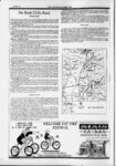
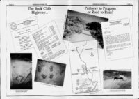
Show f PAGE 10 THE ZEPHYROCTOBER 1992 the Book Cliffs Road (continued) which has always been notorious for its unstable geology and frequent slides. But a major reconstruction project had done much to improve the quality and safety of the toad. Why not save millions of dollars ourselves and, in conjunction with Colorado promote Hwy 139 as the scenic link between Vernal and points south? The road district dismissed the idea at once, dting the instability of the pass. They continued to insist that only a new road. -- their road could fulfill the needs of our growing tourist population. But in December 1989, the road district filed for an "Application for Transportation and Utility Systems and Facilities on Federal Lands" with the BLM. The document stated that Its primary purpose is to provide improved access into the tar sand, oil shale, natural gas and oil deposits located on public lands in that area." . The application stated that the new road would shorten the route from Ouray to Cisco by 37 miles. Is this a significant savings of time (considering the cost) in stimulating tourist traffic? Apparently, it really didn't matter. In part, the application states, "Several existing roads connect Ouray to Cisco, namely US 191 over Indian Canyon.. and Colorado State Road 64 (and 139) over Douglas Pass. Neither of these routes provides access to the energy fields; hence, neither satisfies the primary need of the project Further consideration of these roads is meaningless." It became dear from this document, that the "tourist road" angle was simply that...an attempt to gain broader support for the project by broadening its appeal Throughout the summer of 1989, Jimmie Walker collected dozens of letters of support from Grand County businesses for the construction of a "tourist road." The road wasn't going to cost the county anything. It was Tree money" that was going to build this road. Each county, said Walker, could build their share of the road for only $6 million. To many, it sounded like it was too good to be true. And it was. . , route and determined that It also considered the potential for landslides along the proposed of the road would indeed pass through areas in both East and Hay Canyons unstable landslide Formation-the River same landslide Green of the Member deposits found in the Douglas Creek Colorado. in deposits found on its namesake pass claim that the new road would stimulate energy districts' road With regard to the BLM had this to say: "Although the highway would result development in the Book Cliffs, the to known mineral occurrences, construction of (the Proposed Route) would in improved neither enhance nor diminish the potential for mineral exploration and development since the decisions to undertake these activities." commodity price is the overriding factor in Where to now? It is now up to the public to comment on the BLM s conclusions. It has until December 10 to send written comments on the proposal In addition, public hearings will be held in Salt Lake and locations elsewhere in this issue). City, Vernal and Moab (look for addresses, dotes, times, As might be expected, the Grand, County Roads Special Service District Board is not very with the BLM's recommendation. If the EIS stands, it is extremely doubtful that the OB will still loan the $3 million. Legal action and hundreds of thousands of dollars in attorney foes in the future. may be the way mineral lease funds are expended Education? The hospital? Our strained needs? Grand And what about other pressing County treatment plant? The general condition of roads in the county? Impacts from tourism? . plcH sewage They'll just have to wait. .first things first - Hie project simmered while data was gathered for the EIS. The BLM required the road districts to hire a firm and on February 1, 1990, the road board voted to recommend EN5R Consulting and Engineering to the BLM as the preferred firm to complete the EIS. The cost was expected to exceed $250,000. Meanwhile, questions arose about the Utah Department of Transportation's ability to pave the highway, even if the counties could find a way to fund their share of the work. Studies by UDOT indicated that state roads would need $43 billion in repairs, upgrades and reconstruction over the next 20 years. It was almost double the amount it expects to receive from state and federal funding over that same period of time. The Book Cliffs Highway received a low priority rating, and at a UDOT district meeting in the fall of 1990, Chairman Sam Taylor said, "We made a commitment to pave this road.J didn't say when." Later estimates by Taylor indicated a wait of at least 10 to 15 years before the state might find the money to pave the highway. And in early 1992, a report indicated that a $320 million shortfall over each of the next five years, will allow the state to only make about a third of the badly needed improvements to state roads and bridges. Existing roads and bridges. By May 1992, Thom Wardell, manager of the Uintah Special Service District estimated the cost of the road in their county to be just under $20 million. In Grand County, where the terrain turns rugged almost the instant a vehicle crosses the county line, the cost was bound to be even higher. At a board meeting, Jimmie Walker advised the board to stop using the $6 million figure in public for awhile. August, the Moab City Council withdrew its support of the Book Cliffs Highway. And oil and gas companies that operate in the Book Cliffs area, inducting Beartooth Oil tx. Gas and Northstar Gas withdrew their support of the road as well, encouraging, instead, an improvement of the general condition of roads in the Book Cliffs. In At long last-th- e EIS The one inch thick document released by the BLM evaluated the proposal by the road districts, four alternative highway alignments, a "pave the existing alignment" alternative, and a "no action alternative. Cutting straight to the chase, the BLM rejected the proposal to build a major highway, choosing, instead, to select the "pave the existing alignment" alternative. That option did not seem to appease either side, although it's unlikely that the road districts will consider that alternative, even if it's the only one they have left In considering the proposal the BLM determined what impacts were unavoidable if the road was constructed. They included the loss of important game animals due to road kills, inducting 272 mule deer, 10 elk, 10 antelope, 1 or 2 blade bear, and 1 or 2 mountain 1km each year. The total annual loss to wildlife from road kills was estimated at $540,248. Other impacts included the disturbance of floodplains, the disturbance or destruction of springs in the Fine Spring Canyon area during construction, a potential increase in bald eagje mortality due to motor vehide collisions, about 27,000 board feet of Ponderosa pine and 10,000 board feet of Douglas fir destroyed by road construction, an increase in the number of livestock mortalities, and an adverse impact on the operation of the Broken Bolt Randi. 391 S. Main St. Jaab, Utah WELCOME FAT TIRE FESTIVAL KW I AAOVNT-A-I- N LOCAL DISCOUNT FULL SUSPENSION BIKE RENTALS 15 l E T0VR4 |