| OCR Text |
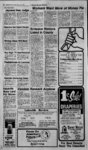
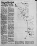
Show W itt irrt r-- .w V. , .'- -. , Canyons Identified As Hazardous by Geological Expert BARRY KAWA - Review Staff SALT LAKE CITY Snow-pac- k and detached land materials in Davis County canyons look much worse than a year ago when a sudden warming trend caused flooding and mudslides, says a state geological hazards expert. Bruce Kaliser, chief of the State Geological Hazards warned Davis County offi- to be prepared for the Divi-Zsjo- seen anything threatening facilities or homes, iT.btft. have seen,' wherever thcYe w'erp slides lastyear, the .conditions are worse this year, saidThe probability is we debris flows j. '' need tQfexpea.-m.or" because-athe snowline retreats, it.s gping'tO bring more debris with i Vf . " -- -- fne J e s -- ce ' Kaliser said snowpack and 5Jftioisture conditions in the can-yoris are worse than they were a as well as the amount . year ago, of oii the slopes from left earth , , . ' f ? the slides of last year.. He said ; minor debris, slides are starting to occur at Tower elevations but ; "are. not a hazard; z At the, higher elevations, "were rrot. yet .finding problems h, because the,Sp6w is still there , - V i" 4,' hasnt really melted yet, atdL--- State geological -- - he de- . . ..,.. , - Z! 4, sr j .Otan Geological & Mineral Vey and the Davis County Sur-- V Sher-.iff- is Office. But Kaliser warned the device fore yesterday, but whether it will provide us with a warning is yet to be determined, he said. State and Davis County officials agree the weather will play a crucial role in the amount of spring runoff that can trigger flooding and mudslides. Weather Service figures estimate snow-pac- k along the Wasatch Front is still at about 140 percent of average for this time of year, slightly higher than at the same 5B levels. The weathers going to hurt us, especially from April through May, he said. Alder said sudden temperature increases to 10 degrees above normal could trigger heavy spring runoff in the mountains. Shepard Canyon Kaliser said state geological findings show snowpack high in water content and a lot of loose rock, soil and steep slopes left from last springs flooding and mudslides. If you had gone up there exactly a year ago, it was nowhere as bad, he said. Farmingfon ( Canyon , If the snow should melt gradually and not in an aggravated Hornet Canyon manner, it will certainly reduce the hazard from debris flows considerably, Kaliser added. Steed Canyon Davis Kaliser also named several canyons in Davis County containing unstable areas of 5,000 to 100,000 cubic yards which could come down with spring runoff. ' Canyon Lone Pine Canvon Ricks The areas, as marked on U.S. geological maps, are in: Holmes Creek and Webb Canyon, Shepard Creek, Orchard Creek and . Canyon Barnard Canyon Parrish Canyon Deuel Creek Canyon An unidentified canyon between Ford Canyon and Davis Creek, three in Baer Creek, three in Barnard Creek, two in Stone Creek, three in Holbrook Creek Canyon and Barton Canyon, and three in Centerville Canvon. Stone Canyon Barton Creek Canyon According to Davis County Planning Director Rick the canyons indicated by Kaliser are ones the county has been working on with their efdollar fort. May-fiel- is still in the experimental stage and is unproven is a slide situation. It was working the day be- f temperatures and precipitation partment personnel have toured in the past two Farmington Canyon, Weber weeks and have taken aerial Canyon near the Weber Basin Job Corps center, Parrish Creek, photographs of the canyons. .Included' in the states efforts is V tekiheterjng device recently in- Stalled ; i nunstable Rudd Creek Canyoji infarmington. The de-vice would transmit warnings of landslides in the canyon to the . CLEARFIELD Steed Creek. v .. Lakeside Review North, Wednesday, April 11, 1984 ,t)ie .canyons 4r - . , time last year. Bill Alder, forecaster for the National Weather Service, predicts April and May temperatures will be cooler than normal with above average precipitation in both months. Alder said the forecast is for weather very similar to last years April and May n, ' rworst. jv ? c I have -- not '. Mill d, Creek Canyon multi-mil- lion flood-contr- ol North Canyon Theyre the canyons weve been working on, he said. In most of those, we have some kind of debris basin projects. Kaliser said, judging from the current state of the canyons, the efDavis County fort of debris basins and channel is very well justified. flood-contr- ol I would say anything a community has done is likely to prove out, he noted. CANYONS that have been identified as those with the highest potential for mudslides in Davis County are shown in red shaded area on this map. The canyons were evaluated in the past two weeks by state geologists who have reported that large areas of unstable land were seen in aerial surveys. There have already been several small slides in lower areas of the mountains. In higher elevations, snowpack is still heavy and little land movement has been detected. |