| OCR Text |
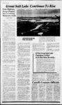
Show DECEMBER 28, 1983 Grewt Sdlt hdk Continues To 1 Nears Highways, Sewage Disposal; And Is Covering Businesses, Farms R. BLODGETT Clipper News Editor By GARY Copyright Dec. 28, 1983, Clipper Publishing Company II'uhj think the rise of the Great Salt Lake and the spring floods of 1983 were devastating-wa- it until next year. U FORDING TO the experts, an extremely lic.n runoff is anticipated next spring - with the odds in favor of a heavier runoff in 1984 than was experienced last spring. Gerald Williams, chief hydrologist forthe National Weather Bureau serving the In.ermoun-tai- n area, emphasized there are too many variables to accurately predict a spring runoff the potential, even in December, is that the runoff will be extremely heavy. TED ARNOW, district chief of the Water -sources Division of the U.S. Geological Ser-- . vice, agrees. But his concern is what the water will do when it reaches the Great Salt Lake. First, let's take a look at the potential runoff based on snow pack and water content already in the mountains. MR. WILLIAMS noted that the overall pack in the mountains of northern Utah is from w ith record 200 to 300 percent of normal snowfall already established for this time of year. Snowpacks and water content of the snow varies greatly from one area to another, Mr. Williams pointed out. But the fact still remains that there is a lot of snow in the mountains and the water content of the snowpacks is above normal. NORTHERN Utah ski resorts have already snow- - recorded record or snowfall d through Dec. 20, with some areas having as much as 200 percent of normal. Fall months of 1982 were recorded high months for snowfall, but these records are being exceeded for the last three months of 1983, said Mr. Williams. happens if the precipitation for January, February and March are average or SO WHAT above average? snowfall in the Even w'ith a for the next three Utah mountains northern is this not and months likely the total preFirst six months of the water cipitation for the year will likely be above average, he said. sub-norm- al - : - WHAT IT BOILS down to is the fact that the first three months have been extremely wet and the outlook for the next three months is for normal or above normal snowfall. with a capital And that spells T. JUST HOW intense the runoff will be, or what affect it will have on the continued rise of the Great Salt Lake, depends on several factors, Mr. Williams explained. The water content in the snowpack is heavy of any amount and with additional snow the next three months will create a condition conducive to a heavy runoff. - FARMINGTON Experimental Station, for example, recorded just over 2.5 inches of precipitation during the period of Dec. 4 to Dec. 19. This is more than the normal for the entire month, according to Mr. Williams. At the Salt Lake International Airport, pre-- ; cipitation from Oct. to date is this sixth wet- test since 1931. MR. WILLIAMS noted that reservoirs are higher than normal and the intensity of the runoff next spring will depend on warm temper-- . atures; how long the temperature stays warmer than normal; how much water can be stored for controlled release; and several other factors. But once the water starts to flow, w hat next? BECAUSE OF the record runoff last spring, Great Salt Lake and Utah Lake are both at record high levels and these records date back to the arrival of the Pioneers in Salt Lake 1 . : - Valley. The most recent recording, on Dec. 15, the south part of Great Salt Lake was 4,205.65 feet above sea level, and the north end of the lake was 4,202.95 feet above sea level, said Mr. Amow. The Southern Pacific Railroad causeway divides the lake. Salt Lake reached after rising 5.2 feet - an its peak in late July into the lake in flow record high water e of records. .any year since the beginning But just as important is the fact that the lake foot after reaching receded only about one-ha- ; THIS YEAR (1984) Great -- ! - tory and the potential runoff from the mountain streams this next spring are potentially very high. Prior to 1983, the record rise of the lake was 3.4 feet in 1862 and again in 1907. The maximum rise of the lake since 1930 is 3.15 feet in 1971, according to U.S. Geological Service records that date back to 1847. AND THE RISE of the lake last spring was the most devastating (financially) in history. Losses to lakeside businesses, industry, shell and mineral operations, and damage to land and structures total several million dollars, Mr. Amow explained. d At the 4,200-foo- t level, Great Salt Lake about million acres. If the lake were to reach 4,210 feet (above sea level), the total land covered by the lake would increase by 50 percent to 1.5 million acres. ecom-passe- 1 THUS, FOR every foot the lake rises - and its expected to rise another 3 to 4 feet this the land to be swallowed up by the spring expanding lake could total a minimum of 200,000 acres. What does that mean to Northwest Salt Lake City and Davis County? -- lf - rate whatever enters the lake, he said. Whatever goes in and doesnt evaporate during the three hot months of the summer will remain in the lake, just like it did last summer. THAT WOULD add to the already high lake level and create even more potential problems in future years. When the lake receded only about foot last summer, it was a record-lodecline since 1865 when the lake dropped only about foot, records show. one-ha- lf , rise would encompass - ROSE PARK Golf Course and much of the residential area of Northwest Salt Lake City is rise in the recorded at about 4,210 feet. A of could extensive cause or flooding lake, less, out. Mr. Amow this area, pointed ot The causeway to Antelope Island already has a large section washed out and ranchers grazing cattle on the island this winter will have to barge their 1,500 or so cattle to the mainland. NORMAL RUNOFF through the first three months of 1984 would see the lake rise to slightly over 4,2 feet. By July 1 - when the lake reaches peak runoff - the elevation could rise to more than 4,208 feet, Mr. Arnow noted. We should hope for a cool spring and a controlled runoff with a hot, dry summer to evapo -- -- ALSO, THERE is more solidity in the north end, and the fresher water entering from the mountain streams would be helpful, he said. -- Refuge Disposal (BARD) site in West Bountiful, according to geological maps of the area. THE SYRACUSE Causeway to Antelope Island State Park would be completely washed out with a rise of only 2 feet, and damage to the park facilities could be extensive with an additional rise of the lake of 3 foot to 5 feet. Salt Lake International Airport, believed by some to be endangered, is recorded on geologicelevation thus would not al maps at 4,200-fee- t be seriously threatened this year. : -- ot ot ; 1 based on past records and geological survey maps : Rise of 2 to 3 feet - Entirely washout Syracuse Causewayfrom Syracuse to the Great Salt Lake State Park on the northern tip of Antelope Island. Cause extensive damage to the Southern Pacific Railroad Causeway and to facilities at the State Park. Rise of 3 to5feet-- - Water would encompass thousands of acres offarm land and waste land surrounding the lake. Water would engulf the Davis County sewer treatment plants and Bay Area Refuge Disposal (BARD) site in West Bountiful; it would destroy all of the Farmington Bay Bird Refuge; endanger railroad tracks running through Davis County; wash out sections of Interstate Highway 80 west of Salt Lake City; and threaten homes and businesses in Rose Park and parts of Davis County. Rise of more than 5 feet - The lake would threaten Interstate Highway 15 in parts of Davis County; cause extensive damage and loss ofproperty Davis in and Rose Park. At this point the lake level throughout County would also creep close to Salt Lake International Airport but would not cause damage or impede air traffic. ot to ot Heres what could happen with the continued rise of the Great Salt Lake INTERSTATE Highway 80 west from Salt A 300-fo- IfThe Great Salt Lake Continues To Rise As It Has Done Recently,,. Lake City to Wendover would be the most seriously threatened. The highway has been diked to 4,209 feet - but that allows for only a slightly more than rise. In Davis County, a rise would encompass the sew'er treatment plants and Bay Area thousands of acres of farm land and some residences. It would also endanger the railroad tracks running through the county and would threaten Interstate Highway 15. Backup of the Jordan River, due to the rising lake, would cause extensive damage in the Rose rise of the to a Park area with a lake, experts believe. SP Railroad causeway be opened and a culvert installed to carry water from the south to the north. This would balance the lake level somewhat, but a ,000 foot culvert would be needed to equalize the two ends of the lake, Mr. Arnow explained. one-ha- lf w - all-tim- through normal evaporation, the the peak the salty lake. only way to release water from was more lake the of rise THUS, THE NET left the This Amow. than 4.5 feet, said Mr. his- recorded in lake level higher than anytime - LAKE REACHES RECORD HIGH, STILL RISING - near-recor- Great Salt Lake has reached a record high level of and is still riswith an additional 3 to 5 feet expected when the lake level ing peaks in July. Any more rise in the lake could cause extensive loss of property and damage to Davis County and Rose Park. Meanwhile, snow pack is 200 to 300 percent of normal for this date, causing a high potential for excessive runoff mext spring. This photo, taken last summer, looks west from Porters Lane, Centerville. ITS JUST like running water into a tub and pulling the plug only a partial way out. The water level just keeps getting deeper and deeper, said Mr. Amow. Can anything be done to reduce the lake level? SINCE THE NORTH end of Great Salt Lake is nearly 3 feet lower than the south end, it has been proposed by some state officials that the Davis County communities, especially Farm- ington south, are busily preparing detention and culverts in anticipation of a heavy spring runoff. But what happens after the water leaves the mountain streams. ALL OF IT will eventually end up in the Great Salt Lake, said Mr. Amow, And for the next several months - at least the lake will continue to rise. S ; :; L ; ; : : H - -- ;; : Cutoffs Concern Officials By TOM BUSSELBERG FARMINGTON - No senior citizen should have to suffer the indignity of a cold house during the winter, especially if those able to provide help arent aware theres a problem. THE CASE of the Salt Lake City woman who suffered the effects of no heat for several days only because the utility thought there was a gas leak and the house vacant, has hit home with the Davis County Council on Aging. Letters have been sent to both Kaysville and Bountiful electrical power agencies asking them to alert Aging officials of instances where a bill hasnt been paid leading to possible power shutoff, says Director Alice Johnson. ALTHOUGH programs for deferring payment or spreading it through the year are available along with specific financial assistance, many elderly wont apply. UP&L already has a program in place to notify appropriate agencies, she added. If were notified, then well tell the utility (of the problem) or get a program to help pay those bills, Mrs. Johnson emphasized. IN OTHER Council on Aging business in their last weeks meeting, she said some decision must be made about providing Information and Referral Service. Currently, Une ited Way largely funds a program that was to receive Aging support based on the percentage of calls relating to that agency. Of about 8,000 calls received during the year, less than two percent were classified in that category. We could absorb that number of calls in Aging, she said, not part-tim- ing many telephone calls are handled at the three centers and Farmington headquarters. THE AGING board has also appointed a new member who will act as nursing home ombudsman. John Egan of Layton, retired as aging and adult services social worker in Price, will fill that role as a liaison between the several convalescent centers and the Council on Aging. A recent assessment of the Councils activities over the last year found compliance in most areas, Mrs. Johnson says, although a federal nutri- tion information analysis guideline has yet to be implemented. NOTLNG ITS something no agency has started, as of yet, she explained it involves determining nutritional makeup of meals provided for seniors, a project that could be coordinated through a university foods nutrition department, for ex-ample, with information fed: : into a computer. ;Nutritional information cur- - t rently is available only up to'. : age 5 and may not apply when- 0 dealing with those year:.: old, she added, noting that ; while the school district makes $ sure their meals meet the four ;; basic food group requirements arent geared specifically ;; to vitamin levels, for example. IN FACT, sometimes the re-- :: ;; 1 75-8- datively hefty meals have ; caused some of the elderly to j gain sufficient weight that ; physicians were concerned ; with some of the frail elderly at I St. Marks Gardens in Kays-- : ville, for example. The programs transpor-- ; tation efforts have been commended, she also noted, for traveling several hundred thousand miles without a major accident or any serious complaints. |