| OCR Text |
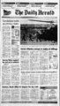
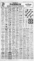
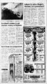
Show The Daily Herald Sunday, February 16, 1992 brecast predicts snow today By Ohio thunderstorm damages buildings The Associated Press By UTAH Sail Lake, Ogden and Provo: Today periods of snow and colder. Snowfall accumulation of 4 inches possible. Highs upper 30s to lower 40s. tonight mostly cloudy with snow showers likely. Colder. Lows Monday partly cloudy with scattered snow showers. Highs Chance of measurable precipitation 80 percent today 70 percent tonight and 30 percent Monday. Statewide: Winter storm warning for the mountains through today. North: Periods of snow today and tonight. Partly cloudy Monday with scattered snow showers. Snow level near 5,000 feet lowering to the valley floors today morning. Colder today. Lows tonight 20 s to 30. H ighs to lower 40s. JSouth: Periods of rain or snow today decreasing from the west. Partly cloudy tonight and Monday with widely scattered showers. Snow level near 5,500 feet lowering to 3,000 feet by tonight. Lows tonight upper teens and 20s. Highs in the upper 30s to near 50. IDAHO Northern Idaho: Cloudy with scattered snow showers decreasing today and Monday. Lows in the s 20s tonight. Highs to 40-4- aged buildings and dumped heavy rain in the Ohio Valley on Saturday, while another storm battering the West piled snow in the mountains and drenched coastal areas. Snow fell in the upper Midwest and began spreading into the Northeast. Feb. 16 Sunday, forecast Accu-Weath- for daytime conditions and high temperatures er 0. Seattle 5. MBbf;X s r ,5. -- ' ijta . . ssYxV r- "fr c K Salt Lake Cityj 48 " 58 San Francisco 1 r S X 581 1 x ' a . Albuquerquel 58 . i ..v vv. xxxxixxr xxx J S j 9 Denverj 55 x.. X " ( fI v" "fx x v ? Los Angeles Thunderstorms developed included 2.36 inches at Me Comb, Miss., and 2.32 inches at Baton Rouge, La. Dothan, Ala. reported 1.64 inches during the six hours ending at p.m. EST. In the West, a strong cold front was producing heavy snow in the southern region of California's Sierra Nevada. Blue Canyon received 37 inches of snow over 24 hours and was under nearly 6 feet of snow by Saturday afternoon. wHHS K ) mid-30- mid-30- ahead of a cold front crossing Indiana and western Kentucky. High wind in central Indiana destroyed a barn, a farm house and a mobile home, caused a garage to collapse and damaged roofs. Thunderstorms and rain also were reported from northern Florida and the central Gulf Coast to North Carolina and southern Ohio. Heavier rainfall totals for the six hours ending at 7 a.m. EST A strong thunderstorm dam- 2-- 25-3- The Associated Press x x x xTx x x xfx x r " i I IZI I V ' I I I I x v Pacific Ocean 1992 Accu-Weathe- VA El Paso 65 Inc. r, r XXX X X XXX mid-40- s. Southwestern Idaho: Mostly SHOWERS cloudy today and tonight with a chance of snow showers: Partly sunny Monday after morning low clouds and fog. Lows in the 20s and 30s. Highs mid-30- s to mid-40- s. FLURRIES RAIN Via Associated SNOW Southeastern Idaho: Mostly SUNNY PT. CLOUDY CLOUDY Press Lows 25 to 30. Monday partly sunny after morning fog and low clouds. Highs near 45. NEVADA Northern and central Nevada: Scattered snow showers today. A chance of snow showers east tonight partly cloudy with a slight chance of showers west. Partly cloudy Monday with a few mountain snow showers. Overnight lows in the teens to lower 20s tos 5 to night. Highs in the east and in the 40s west. Southern Nevada: Scattered showers today. Snow level around cloudy today and tonight with a chancee of snow showers. Partly sunny Monday afer morning low clouds and fog. Lows in the 20s and 30s. Highs in the 30s to low 40s. Treasure Valley: today and tonight mostly cloudy with a decreasing chance of snow showers. But, an increasing chance of night and morning fog. Highs in the 40s. ICE mid-30- mid-40- 4,500 feet. Partly cloudy tonight and Monday with a few mountain s snow showers. Lows in the to Highs in the upper 40s to upper 50s. Only at mid-30- mid-40- s. COLORADO Winter storm watch mountains and southwest through today. Windy at times and turning cooler today with snow mountains and southwest possible accumulations in excess of 10 inches by late in the day. Snow mixed with rain widespread in the western valleys scattered in the northeast. urn Your "Maine" Lobster Place This Monday only, enjoy exceptional savings and TELEVISIONS more on: VCRs STEREOS BOOM BOXES CAMCORDERS CD PLAYERS PERSONAL STEREOS CAMERAS TELESCOPES lllllllM' i ? WORD PROCESSORS II o) Cj c I MICROWAVE OVENS USE OUR EXTRAS PLAN WITH YOUR W50 MINIMUM PURCHASE IN ANY OF THE DEPARTMENTS LISTED, MONDAY, FEBRUARY 17 ONLY. Repayments must be made in 12 equal monthly payments. There is no finance charge if payments are made as scheduled. Ifpa yments are not made as scheduled, a monthly periodic interest rate of 1.5 shall be made on the Average Daily Balance. This corresponds to 18. TYPEWRITERS TELEPHONES 'ANSWERING MACHINES vJuuiiLX) an Annual Percentage Rate of - COMPUTERS All accounts must be in good standing and are subject to credit approval. Zi DISHWASHERS RANGES REFRIGERATORS DAYBEDS WASHERSDRYERS CHAIRS LAMPS L0VESEATS SOFAS DININGBEDROOM FURNITURE MATTRESSES WALL DECOR ORIENTAL RUGS MUCH MORE CM Shop all Mores this Monday 9 a.m. to 9 p.m.: order by phone: We gladly accept your ZCMi Option Charge. MasterCard'. In Salt Lake. elsewhere in ttah and in the t'.S.. VISA'. American Express. Diners Club'. Cane Blanche', and Discover' cards. 579-66- |