| OCR Text |
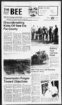
Show "Tf 2B The Summit County Bee ' WVW H Nr" " Friday, September 2, 1988 Public Notices NOTICE TO WATER USERS The State Engineer received the following to Application(s) Exchange Water in Summit County (Locations in SLB&M unless otherwise designated). Persons objecting to an application must file a Protest stating the reasons for the protest To have a hearing before the State Engineer, persons must request a hearing in the ProtesL Protest must be filed in duplicate with the State Engineer, 1636 West North Temple, Salt Lake City, Utah 84116, on or before OCTOBER 16, 1988. These are informal proceedof the ings as per Rule R625-6-Division of Water Rights. (801-538-724- 0) 2 (E2591) APPLICANT. 35-AR- Marlene J. Job, 1980 West Afton Circle, Layton, UT. seeks the right to exchange water as evidenced by Western Land Contracts Corp. with contract from Weber Basin Water September 20, 1988, at the hour of 11:00 a.m. of said day; for the purpose of foreclosing a trust deed dated December 28, 1984 executed by Manhattan Assoc iatesPark City Joint Venture, a Utah general partnership, as Trustor, covering real property located at 2948 Fenchurch 4, Park City, Summit County, Utah and more particularly described as follows: Unit 4. FENCHURCH CONa Utah expandable Condominium Project, together with a .02893646 undivided ownDOMINIUMS, ership interest in the Common areas and Facilities of said FENCHURCH CONDOMINIUMS, as identified and established in the Record of Survey Map filed and recorded May 24, 1982 as Entry No. 191714 and the Declaration and of FENCHURCH By-La- CON- DOMINIUMS. recorded May 24, 1982 as Entry No. 191715 in Book M220 at Page in the office 2 661-73- Conservancy District, under of the Summit County Recorder. US Bureau of This property is now reported to A10990, Reclamation. CURRENT 0.22 QUANTITY: RIGHT: ac. ft. SOURCE: Causey Reservoir. POINT(S) OF DIVERSION (1) S 560 W 1040 from El4 Cor. Sec 34, T7N, R3E. USE: Irrigation, domestic, municipal, industrial, be owned by Richard Milliron. Dated this 18th day of August, 1988. David B. Boyce Successor Trustee Published in the Summit County Bee Aug. 26 and Sept 2 and 9, 1988. power, and stockwatering. HEREAFTER: 0.33 ac-f- t. is to be released at a point same as L Current Right; and 0.33 is to be diverted from SOURCE: Unnamed Spring. POINT(S) OF DIVERSION: (1) N 2000 2350 from SW Cor. Sec 29. T7N, R3E. (Lot 540 Evergreen Park) USE:1 Irrigation: from Apr 1 to Oct 31, ac-f- total acreage Stockwatering: 1 0.02 acs; head of livestock; family. PLACE OF USE: NE14 SW14 Sec 29, T7N, Domestic: 1 R3E. Robert L. Morgan, PE. STATE ENGINEER Published in the Summit County Bee Sept. 2, 9 and 16, 1988. NOTICE OF TRUSTEE'S SALE The following described property will be sold at public auction to the highest bidder, payable in lawful money of the United States at the reasons for the protest. To have a hearing before the State Engineer, persons must request a hearing in the Protest Protest must be filed in duplicate with the State Engineer, 1636 West North Temple, Salt Lake City, Utah 84116, on or before OCTOBER 2, 1988. These are informal proceedof the ings as per Rule R625-6-- 2 State of Utah, and being described as follows: Trustor Michael C. Hess, Scou T. Starkey, Bruce H. Moon. Trustee: Western Slates Title Company of Summit, a Utah Corp. Beneficiary: Echo Creek Ranch, a Utah Limited Partnership. Recorded: 06 Nov 1979 Entry No.: 161072 Book: 145 Page: 434 And covering real property more particularly described as follows: Lot 62, Echo Creek Ranches, according to the official plat thereof on file and of record in the Summit County Recorder's Office. Dated this 17th day of August, 1988. ASSOCIATED TITLE COMPANY. A UTAH CORPORATION TRUSTEE Blake T.Heiner By Vice President 0) APPLICATION(S) 21-15- 87 South, 8, T2N, R10E. (A63448) APPLICANT: Ronald B. Mills, 2557 East 9800 21-15- 88 South, Sandy, UT. QUANTITY: 0.015 cfs. SOURCE: 6 in. well 100 ft to 250 ft deep. POINT(S) OF DIVERSION: (1) S 780 W 300 from NE Cor, Sec 9. T2N, R10E. (Manorlands Lot 303) USE: Domestic: 1 family. PLACE OF USE: NE14NE14 Sec 9, T2N, R10E. FC-63- 1 Published in the Summit County Bee Aug. 26 and Sept 2 and 9, 1988. NOTICE TO CONTRACTORS Sealed proposals will be received the Summit County by Commission, at the county office Coalville, Utah, until 2:00 p.m. September 7, 1988 and at that time publicly opened for the Old Ranch APPLICATION(S) Regulations (UACR), the Executive Secretary of the Utah Conservation Committee Air has to ' be scheduled .a public bearing held on the subject of W. W. Clyde's application to locate a gravel crushing operation near the city of Francis, Utah. The purpose of the public hearing will be to receive comments on the technical aspects of the application and the proposed operating conditions. The hearing is part of a y public comment period which will end on September 14, 1988. The public hearing will be held on Monday, September 12, 1988 at 7:00 p.m. The location will be the Park Building, 400 South Main, Kamas, 1 30-da- 35-AR- Blvd. Road Construction Project. The principle items of work are approximately as follows: Associ- Utah. Published in the Summit County Bee Sept. 2, 1988. NOTICE OF TRUSTEES SALE The following described property will be sold at public auction to the highest bidder, payable in lawful money of the United States at the time of sale on the New South entrance of the Summit County Courthouse, Coalville, Utah, on j! Dated this 23rd day of August, 1988. NOTICE OF TRUSTEE'S SALE The following described property will be sold at public auction to the highest bidder, payable in lawful money of the United States at the time of sale, at the west front door of the Summit County Courthouse, in Coalville, Utah on 23, Sept. 1988, at 12:00 o'clock P.M. of said day for the purpose of foreclosing that certain trust deed dated 25 Oct. 1979, and recorded in the office of the county recorder of Summit. Summit County Commission Published in the Summit County Bee Aug. 26 and Sept. 2, 1988. NOTICE TO WATER USERS The State Engineer received the following Application(s) to Appropriate, Change, or Exchange Water in Summit (Locations in SLB&M). County Persons objecting to an applicaa Protest stating the tion must file G. LaMar Pace Salt Lake City, UT. 3, evidenced by U.S. Bureau of Reclamation and Contract with Weber Basin Water Conservancy District under 2 (A27614) and . . awarded the contract, the bidder will execute the contract and furnish the contract bonds as required. The right to reject any or all bids is reserved. 1-- seeks the right to exchange water as ly David B. Boyce Successor Trustee Published in the Summit County Bee Aug. 26 and Sept 2 and 9, 1988. TO EXCHANGE WATER (E2600) APPLICANT: Louise Christensen, 7430 Wasatch 2-- D Under the authority of Section 3.1.3, Utah Air Conservation UT. Bountiful, QUANTITY: 0.015 cTs. SOURCE: 8 in. well 100 ft to 300 ft deep. POINT(S) OF DIVERSION: (1) N 620 W 500 from El4 Cor, Sec 8, T2N, R10E. (Lot 310, Pine Plateau Est 3) USE: Domestic: 1 family. PLACE OF USE: SE14NE14 Sec 17 NOTICE TO APPROPRIATE WATER (A63423) APPLICANT: Robert D. Bills, 377 West 800 ated road work for 0JO mile road time of sale on the New South realignment. entrance of the Summit County The project is to be completed in Courthouse, Coalville, Utah, on 20 working day. September 20, 1988, at the hour of Proposal forms, plans, and speci11:00 a.m. of said day, for the purfications are on file in the office of pose of foreclosing a trust deed dated the Summit County Road DepartNovember 21, 1980 executed by ment Superintendent at the Summit Martin Shimek, as Trustor, coverCounty Courthouse, 10 North Main ing real property located at 413 Silin Coalville, Utah phone (801) 336-ver Town Condo, Park City, Sum- 4451 and Uintah Engineering, Inc mit County, Utah and more 85 South 200 East in Venial, Utah, described as follows: where they phone in Building I, Silver may be reviewed by prospective Unit Town Condominiums, a Utah bidders. Specifications, proposal Condominium Project, together forms, and plans may be obtained with a 5.0 undivided ownership only at Uintah Engineering, Inc.,, interest in common areas appurupon application and payment of a tenant to said Unit as established fee of $50.00 no part of which will . and identifed in the condominium be refolded. dochuhtton, filed for Record as Entry Each bidder must submit ai bicP No. 137917 and the survey map bond from an approved surety com- -' filed for record as Entry No. pany on forms provided by the 132627. council; or in lieu thereof, cash, . This property is now reported to certified check, or cashier's check for be owned by Silver Town 413 not less than 5 of the total Partnership, a Partnership. amount of the bid, made payable to Dated this 18th day of August, Summit County as evidence of . 1988. good faith and a guarantee that if parti-clular- of Water Rights. Division r 35-83- (A35794). 35-14- 96 RIGHT: CURRENT QUANTITY: 1.0 ac-- ft SOURCE: Smith and Morehouse Reservoir. POINT(S) OF DIVERSION: (1) S 3589 E 91 from Nl4 Cor. Sec 1. T1S, R7E. USE: Irrigation: from Jun 15 to Oct 1, total acreage 2836.60 acs. PLACE OF USE: Sec 15; Sec 21; Sec 22; Sec 27; Sec 28; Sec 29; Sec 30; Sec 32; Sec 33, T1S; Sec 4; Sec 5; Sec 9, T2S, R6E. HEREAFTER: 1j0 ac-- ft is to be released at a point same as Current is to be Right; and 1.0 ac-diverted from SOURCE: Gardners Fork. POINT(S) OF DIVERSION: (1) N 2150 W 200 from SE Cor, Sec 35. TIN, R8E. (Holiday Park) USE; Domestic: 1 family. PLACE OF USE: NW14SW14 Sec 36, TIN, R8E. ft (E2626) APPLICANT: 35-AR- Pamela E. Dow, 20 South 800 East Bountiful, UT. seeks the right to exchange water as evidenced by Contract with Metropolitan Water District of Salt Lake City. CURRENT v ; RIGHT: QUANTITY: 1.0 ac-- ft SOURCE: Deer Creek Reservoir., POINT(S) OF DIVERSION: (1) N 700 E 100 from SW Cor. Sec 5, TSS, R4E. USE: Other: Irrigation, domestic, power, industrial and stockwatering with the Provo River. HEREAFTER: 1 J) ac-- ft is to be released at a point same as Current is to be Right; and 1.0 ac-diverted from SOURCE: 6 in. well 100 ft to 400 ft deep. POINT(S) OF DIVERSION: (1) N 170 W 510 from SE Cor, Sec 25, T2S, R6E. (Lot 380 Samak Hills Addition) USE: Irrigation: from Apr 1 to Oct 31, total acreage 0.25 acs; Domestic: 1 family. PLACE OF USE: SE14SE14 Sec 25. T2S, R6E. ft Conservancy District, under 35-8fA32272). (A2761 1) and 30 CURRENT Your support would be appreciated Primary September 13th Don't forget to Vote RIGHT: QUANTITY: 1.0 ac-- ft SOURCE: East Canyon Reservoir. POINT(S) OF DIVERSION: (1) S 1820 E 1930 from NW Cor, Sec 10. T2N, R3E. USE: Irrigation, municipal, domestic, and industrial, stock watering. HEREAFTER: 1 J) ac-- ft is to be released at a point same as Current is to be Right; and 1.0 ac-- ft diverted from SOURCE: 6 in. well 100 ft to 400 ft deep. POINT(S) OF DIVERSION: (1) S 400 W 1800 from NE Cor, Sec 1, T2S, R3E. (South East of Park West) USE: Irrigation: from Apr 1 to Oct 31, total acreage 0.25 acs; Domestic: 1 family. PLACE OF USE: NW14NE14 Sec 1, T2S. R3E. (E2629) APPLICANT: Kathleen Butcher, 3401 South 4300 West West Valley, UT. seeks the right to exchange water as evidenced by Beaver & Shingle Creek 35-AR- Irrigation Company Certificate: 1655, under T. Right; and 0.4 ac-- ft is to be diverted from SOURCE: 6 tin. well 100 ft to 300 ft deep. POINT(S) OF DIVERSION: (1) S 465 E 135 from Nl4 Cor, Sec 26, T2S.R6E. (3 miles east of Kamas) USE: Domestic: 1 family from Apr 1 to Nov 30. PLACE OF USE: NW14NE14 Sec 26, T2S, R6E. 35-88- 80 September Redevelopment Agency of Summit County, Utah. The proposed project area covered by the redevelopment plan coven the following area, to wit: Beginning at a point which is south 8943'02" east along the Sec- tion line 2987.67 feet and south 35-46- (35-169- Stockwatering: 381 head of livestock; Domestic: 2 families. PLACE OF USE: SE14SW14 Sec32.T4N.R4E. HEREAFTER: QUANTITY: 0.048 cfs or 11.9 ac-- ft SOURCE: Unnamed Springs. POINT(S) OF DIVERSION: Same as Heretofore (1) N 177 E 494 from Wl4 Cor, Sec 8. 13N (2) N 756 W 1 14 from SE Cor (3) N 379 W 358 from El4 Cor, Sec 31 (4) N 781 E 1344 from SW Cor, Sec 32, T4N, R4E. (Northwest of Henefer) STORAGE: Same as Heretofore USE: Stockwatering: 7 head of livestock; Domestic: 26 families. PLACE of USE: N12NW14 Sec 5. T3N; S12SW14 Sec 32, T4N, R4E. The remaining water is used same as Heretofore. Robert L. Morgan, P.E. STATE ENGINEER Published in the Summit County Bee Aug. 19, 26 and Sept. 2, 1988. NOTICE OF TRUSTEE'S SALE PLEASE TAKE NOTICE that the following described property will be sold at public auction to the highest bidder, payable in lawful money of the United Stales at the time of sale, at the front steps of the Summit County Courthouse, Coalville, Utah, the 12th day of September, 1988, at the hour of 9:00 A.M. of said day, for the purpose of foreclosing a Trust Deed executed by BANBERRY CORDEVELOPMENT PORATION, Trustor, in favor of S. M.. HORMAN, Sole Trustee of The Horman Trust, Beneficiary, covering real property located in the Jeremy Ranch Subdivision, Summit County, Utah, and more particularly described as: Lot 21 of the JEREMY RANCH SUBDIVISION, PLAT 1. recorded in the records of Summit County, Utah. . DATED this 9lh day of August, 1988. STEPHEN B. MITCHELL Successor Trustee 139 East South Temple, 2001 Sab Lake City, UT 84111 355-66- 488.51 feet (based on the Utah Stale Coordinate System, Central Zone) from the northwest comer of Section 22, Township 1 South, Range 4 East, Salt Lake Base and Merid- RIGHT: 35-16- 91 77 . the County Cuummssion chambers. Summit County Courthouse, Coalville, Utah. The purpose of die public hearing is to consider adopting the redevelopment plan entitled, "Silver Creek Industrial Redevelopment Project Area Redevelopment Plan to be dated as of September 7, 1988 to provide for projects to be undertaken by the 6) Slock 35-88- 52 r 32 CURRENT O NOTICE that the Bor sioners of will hold 35-AR- QUANITITY: 1.0 ac-- ft SOURCE: Smith and Morehouse Reservoir. POINT(S) OF DIVERSION: (1) S 3589 E 91 from Nl4 Cor, Sec 1, T1S, R7E. USE: Irrigation: from Jun 15 to Oct 1. total acreage 2836.60 acs. PLACE OF USE: Sec 15; Sec 21; Sec 22; Sec 27; Sec 28; Sec 29; Sec 30; Sec 32; Sec 33, T1S; Sec 4; Sec 5; Sec 9, T2S. R6E. HEREAFTER: U) ac-- ft is to be released at a point same as Current is to be Right; and 1.0 ac-- ft diverted from SOURCE: 6 in. well 100 ft to 400 ft deep. POINT(S) OF DIVERSION: (1) N 1600 E 300 from SW Cor, Sec 36, TIN, R8E. (Lot 78 Alpine Acres) USE: Domestic: 2 families. PLACE OF USE: W12SW14 Sec 36, TIN, R8E. APPLICATION) TO CHANGE WATER (A14740) APPLICANT. William & Linda Roberts, P.O. Box 105, Henefer, UT. proposes to change the place and nature of use of water as evidenced by Dil. 123 1693, 1694, HERETOFORE: QUANTITY: 0.048 cfs or 11.9 ac-- ft SOURCE: Unnamed Springs. POINT(S) OF DIVERSION: (1) N 177 E 494 FTOm Wl4 Cor, Sec 8. T3N (?) N 756 W 114 from SE Cor (3) N 379 W 358 from El4 Cor. Sec 31 (4) N 781 E 1344 from SW Cor, Sec 32, T4N, R4E. USE: Irrigation: from Apr 1 to Oct 31, total acreage 0.25 acs, sole supply 0.25 acs; ; of Sumni (E2631) APPLICANT: Bonnie J. Rottmaim, 2561 Central Park Circle, Bcnnion, UT. seeks the right to exchange water as evidenced and by UJS. Bureau of Reclamation Water Basin Contract with Weber 35-8Conservancy District under and (A35794). (A27614) Published in the Summit County (Award 852), (Award 862), Bee Aug. 19 and 26 and Sept. 2, and 1988. (Award 880), WRD. 35-88- 62 kdMrtMttUNMMih AC-F- SOURCE: Beaver Creek. FOINT(S) OF DIVERSION: (1) S 264 E 2112 from Wl4 Cor, Sec 22, T2S.R6E. USE: from Mar 1 to Nov 1, Irrigation and stockwatering. HEREAFTER: 0.4 ac-- ft is to be released at a point same as Current (E2628) APPLICANT: Harold R. and Ruth B. Weight, 35-12- 13 Republican Candidate 4 year County Commission Seat 0.4 QUANTITY: 35-AR- 2320 West Redpine Road, Park City, UT. seeks the right to exchange water as evidenced by U.S. Bureau of Reclamation and Contract with Weber Basin Water PUBLIC (Board of RIGHT: CURRENT ian. Thence South 45.55 feet; thence South 3000t)0" East 600.00 feet; thence South 3500'00" East 1558.00 feet; thence South 318.10 feet to the quarter section line; thence North 8936'45 West along said quarter Section line 350.00 feet; thence North 7000D0" West 900.00 feet; thence North 3O00W West 450.89 feet to a curve to the right having a radius of 773.56 feet; thence southwesterly 442.66 feet around the periphery of said curve (chord S 5051'23 W 436.65 - feet); thence south 6715'00 west 4.40 feet; thence South 3000'00" East 484.00 feet to the center, of said Section 22; thence South 00H'30 East along the quarter Section line 414.50 feet; thence South 5935D9 West 1044.35 feet y line of to the existing U.S. Highway No. 40; thence along line as follows: said North 192827" West 605.62 feet; North 37o3509" East 100.00 feet; North 5234'51" West 100.00 feet; South 3735U9" West 65.00 feet; North 4126'3r West 732X11 right-of-wa- right-of-w- ay feet; . thence leaving said line North 480620" East 345.73 f feet; thence North 15e5120" East right-of-wa-y 241.81 feet; thence South 3700W East 56.45 feet; thence North 155120" East 96.01 feet; thence North 5536'20" East 389.16 feet; thence North 4151'20" East 405.43 feet; thence North 4135'47 East 729.84 feet; thence North 5823T5" East 600.50 feet to the point of beginning. Containing 100.00 acres. Persons having objections to the proposed redevelopment plan, or who deny the existence of blight in the proposed project area, or the regularity of any proceedings may appear at the hearing or may file written objections prior to the hearing with the Agency, showing cause why the proposed redevelopment plan should not be adopted. A copy of the proposed redevelopment plan is on file for public. inspection in the office of the Agency in the Summit County Courthouse, Coalville, Utah. By order of the Board of Directors of the Redevelopment Agency of Summit County, Utah, this 3rd day of August. Board of County Commissioners Summit County, Utah Thomas E. Flinders Chairman Published in the Summit County Bee Aug. 12, 19, 26 and Sept 2, 1988. Beware Firewood Cutters The Kamas District of tl e National Forest, cooperation with Summit Coun Sheriffs Office, conducted surprise roadblock on Satnrda Aug. 20, and checked all vehicl Wasatch-Cach- containing firewood. Bch load was checked for permit and the permit checked f validation. While everyone did ha a permit, a high percentage C Percen0 of the permits were eith not punched out er not attached die load as required, and resulted citations being issued. Because of the poor compliant of pomtt validatym, more surpri roadblocks will be conducted in future. d i . |