| OCR Text |
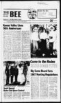
Show The Summit County Bee Coalville, UT 84017 Friday, May 29, 1987 3B Public Ktatices NOTICE OF TRUSTEES SALE enjoy each of the Limited Common Areas which is appurtenant to said Unit; and (c) The nonexclusive right to use and enjoy the Common Areas and Facijities included in said Con- The following described property will be sold at public auction to the highest bidder. June 23. 1987. payable in lawful money, of the United States at the time of sale, at the front steps of the Summit County Courthouse. Coalville, Utah, at the hour of 12:00 Noon of said day. for the purpose of foreclosing a trust deed executed by BRUCE HILL, as trustor, in favor of BANK & TRUST COMPANY, as beneficiary, recorded December 5. 1980 as Entry No. 173610 in Book M173. Page 566, of the official records of Summit County. State of Utah, covering real property located at Unit NRed Pine Chalets, Snyderville. Utah, and more particularly described as: dominium Project (as said Project may hereafter be ex- panded) in accordance with the aforesaid Declaration and Survey Map (as said Declaration and Map may hereafter be amended or supplemented) and the Utah Condominium Ownership Act. TRACY-COLLIN- S Notice of Default was recorded February 22. 1987. as Entry No. 265333 in Book 418, Page 110 of said official records. Said sale will be made without covenant or warranty, express or implied, regarding title, possession or encumbrances. DATED this 15th dav of Mav. -l 1987. i Unit No. 1 in Building N contained within the RED PINE CHALETS. PHASE TWO. as the same is identified in the Record of Survey Map recorded in Summit County. Utah, as Entry No. 166718. and Amended, as Entry No. 173066. and in the Declaration of Covenants. Con- W. CLARK BURT Successor Trustee For further information contact 4 Brenda McCurdy at 530-739- CN5656B Published in the Summit Countv Bee May 29, June 5. and 12. 1987. ditions and Restrictions and Bvlaws of the RED PINE CHALETS. PHASE TWO recorded in Summit County. Utah, as Entry No. 166720. in Book at Page 258 and the Amended Condominium Declaration for RED PINE CHALETS. NOTICE OF TRUSTEE'S SALE The following described property will be sold at public auction to the highest bidder. June 23. 1987, payable in lawful money of the United States at the time of sale, on the ftont steps of the M-15- 8, PHASE TWO. recorded in Summit County, as Entry No. 173065. in Book at Page 248. TOGETHER WITH: (a) The undivided ownership interest in M-17- 2. Summit County Courthouse. Coalville, Utah, at 12:00 Noon of said day. for the purpose of foreclosing a trust deed executed said Condominium Project's Common Areas and Facilities which is appurtenant to said bv DAVID B. HANDY, a married man. J. SCOTT HANDY, a married man and BRENT N. JOHNSON, a married man, as trustors, recorded May 21, 1980 as Entry No. 166877 in Book M158, Page 609. of the official records of Summit County, State of Utah, in favor of HUNTER SAVINGS ASSOCIATION, an Ohio Savings and Loan Association by an Assignment of Trust Unit, said undivided ownership interest as initially established (the referenced being 170 Declaration of Condominium providing for periodic alteration both in the magnitude of said undivided ownership interest and in the composition of the Common Areas and Facilities to which said interest relates): (b) The exclusive right to use and Caution wrth Fires Please be careful with any fire as you go into tne That was the appeal of federal and state agencies as Utahns made arrangements to observe the long Memorial Day weekend. Outdoor conditions are several weeks ahead of normal for this time of year, according to Roger Erb, fire management officer in the Bureau of Land Management's Utah State Office. Conditions right now are usual for late June. Some small range fires already have occurred throughout the state. Erb said, and some of the bureau's summer temporary fire fighters have already reported for duty. Adding to the complication of the early hot and dry spring this year is the accumulation of vegetation on the range because of abnormally wet years recently. BLM, U. S. Forest Service, state and county fire officials work cooperatively in Utah to suppress all fires. Anyone seeing a fire should report it to the nearest office of the county sheriff or land managing agency. Officials are asking the public to be extra this spring find summer. Follow common sense rules, Erb suggested: keep campfires small ami don't leave any embers unattended; be careful with matches and cigarettes; prevent hot motors and exhausts (such as on vehicles) from sparking dry grass or dead plant material (duff). off-roa- d Deed dated June 13. 1985 and recorded July 5. 1985 as Entry No. 236128 in Book 347 at Page 776. of said official records, covering real property located at Unit Red Pines Condominiums. Snyderville. Utah, and more particularly described as: David B. Boyce Vice President Published in the Summit County Bcc May 29. June 5. and Unit No'. 4 in Building C contained within the RED PINE CHALETS. PHASE ONE. as the same is identified in the Record of. Survey Map recorded in Summit County. Utah as Entry at No. 164351. in Book Page 740. and in the Declaration of Covenants. Conditions and Restrictions and Bylaws of the RED PINE CHALETS. PHASE ONE recorded in Summit County, Utah, as Entry No. 164352. in Book at Page 741. TOGETHER WITH: (a) The undivided ownership interest in have been filed with the State M-15- 2. said Condominium Project's Common Areas and Facilities which is appurtenant to said Unit, said undivided ownership interest as initially established (the referenced Decbeing 1 laration of Condominium providing for periodic alteration both in the magnitude of said undivided ownership interest and in the composition of the Common Areas and Facilities to which said interest relates); (b) The exclusive right to use and enjoy each of the Limited Common Areas which is appurtenant to said Unit; and (c) The nonexclusive right to use and enjoy the Common Areas and Facilities included in said Condominium Project (as said Project may hereafter be expanded) in accordance with the aforesaid Declaration and Survey Map (as said Declaration and Map may hereafter be amended or supplemented) and the Utah Condominium Ownership Act. Notice of Default was recorded February 9, 1987. as Entry No. 265191 in Book 417. Page 705 of said official records. Said sale will be made without covenant or warranty, express or implied, regarding title, possession or encumbrances. DATED this 15th day of May, 1987. RICHARD K. NEBEKER Successor Trustee For further information contact: 4 Brenda McCurdy at 530-739- CDN2262N Published in the Summit County Bee May 29. June 5. and 12. 1987. Pursuant to Title 53, Chapter 20. Section 2. Utah Code Annotated 1953. Notice is hereby given that the Board of Education of the North Summit School District will conduct a hearing at 7:00 p.m.. Wednesday. June 10, 1987 in the Board Room located at 75 East 100 South. Coalville. Utah for the purpose of adjusting the 1986-8- 7 budget. At 7:30 p.m. in the Board Room, a public hearing on the 1987-8- 8 tentative budget will be held, and after said public hearing on the above mentioned budget in balance. The 1987 Utah Legislature also enacted the largest tax increase in the state's history. Foundation analysts point out . that the adjusted sales volume in 1986 was at about the same level as it was back in 1978. In effect, there has been virtually no growth in Utah business activity over the past eight years. By contrast, business activity (as measured by adjusted sales (or an volume) increased 78 average of 7.5 per year) in the period between 1970 and 1978. All eight of these years registered positive economic growth $28,621,000 in 1975. and, $10. in Utah. During the period 1970. in 992.000 between 1978 and 1986, on the In the state as a whole, business activity declined for the other hand, there was negative second .consecutive year. Gross growth in five of the eight years. Total sales volume in Utah sales volume dropped by 1.5 lasfyear. When an adjustment is during the 1986 calendar year made for the .9 decline in the amounted to SI 2.4 billion accordpurchasing power of the dollar, ing to the Foundation report. the total reduction in the This was equal to about 69 of the total personal income in the effective sales volume amounted slate for the year. In 1978, sales to 3.4 in 1986. The continued slowdown in volume in Utah was equal to business activity has contributed about 80 of personal income. to the financial problems faced In other words, Utahns currently by state and local governments in arc spending a much smaller Utah. The sales tax is the most proportion of their personal important revenue source for the income on taxable items than state as well as for many Utah they did in the late 1970s. A cities. Because sales and use tax larger percentage of their income collections have been well below now is probably going to meet earlier budget forecasts, the other obligations (interest payments, taxes, housing costs, state had to cut back on 1986-8lebi. medical hills on aiiihurizaiinns repavim in expenditure ml suhi i I'lu t!,. three differcnct nccasi"ti during etc.) ilia1 i m, the and u sales '.is. order in the your keep Business activity in Summit County, as measured by sales and use tax receipts totaled 5195.484.000 last year, an increase of 3.9 over 1985. This was reported by Utah Foundation, the private tax research organization, in an analysis of business activity in communities throughout Utah. The study emphasized that this change was based on gross sales volumes inflation allowbefore a 1.9 ance. Gross sales volumes in Summit. County totaled $188,169,000 in 1985. $88,774,000 in 1980. 1 . 7 i 1987-8- 8 school year. On file with the Business Administrator is a ropy of the proposed budget and it is available for public inspection. Board of Education The following application(s) Engineer to appropriate, change, or exchange water in Summit County throughout the entire vear unless otherwise designated. Locations in SLB&M. APPLICATIONS) TO APPROPRIATE WATER 4. T4N, R4E. (A62412) APPLICANT: Gcncttc Williams, 1763 21-15- Valley View Drive, Layton. UT. QUANTITY! 0.015 cfs. SOURCE: 6 in. well 100 ft. to 175 ft. deep. P01NT(S) OF DIVERSION: (1) S 580 E 1030 from NW Cor. Sec 15. T2N. R10E. (Wilderness Acs. 8. 819) USE: Domestic: family. PLACE OF USE: NW' NW'4 Sec 15. T2N. R10E. Lot 1 Scott S. McMichacI Business Administrator Published in the Summit County Bcc May 29. 1987. Thc following described property will be sold at public auction to the highest bidder, payable in lawful money of the United States at the time of sale at the new South entrance of the Summit County Courthouse, Coalville. Utah, on June 24. 1987 at the hour of 2:00 p.m. of said day; for the purpose of foreclosing a trust deed dated March 16, 1983, executed by Steven W. Holcomb and Jean Anne Holcomb, as Trustors, covering real property located at 90 Crestline Drive, Park City. Summit County, Utah and more particularly described as follows: Subdivision, according to the official plat thereof, recorded in the office of the Summit County Recorder. Dated this 22 dav of May. I98T WATER (E2508) A CANT: APPLI- Johannes K. Ostmeier, East Chalk Creek Road, Coalville. UT. seeks the right to exchange water as evidenced by Chalk Creek Hoytsville Water User's Corporation Stock Certificate: 349, under (A8170c). Weber River Decree. CURRENT RIGHT: QUANTITY: 1.0 SOURCE: Joyce and Boyer Lakes. POINT(S) OF DIVERSION: (1) S 735 E 21 from N' Cor. Sec 34. T2N, R8E. USE: Irrigation: from Jun 15 to Sep 30, total acreage 2000.00 acs. PLACE OF USE: Sec 4. TIN; Sec 4; Sec 8; Sec 9; Sec 10; Sec 11; Sec 12; Sec 16; Sec 17; Sec 20; Sec 21; Sec 28; Sec 29; Sec 32; Sec 3402 35-88- ac-f- t. 33, T2N, R5E; Sec 4; Sec 5; Sec 7, T2N. R6E; Sec 5; Sec 6. T2N. R7E; Sec 25; Sec 26; Sec 27; Sec 34; See 35; Sec 36. T3N. R6E. is to HEREAFTER: 1.0 ac-f- t. be released at a point same as Current Right; and 1.0 ac-f- t. is to be diverted from SOURCE: Existing 6" well, 70 feet deep. POINT(S) OF DIVERSION: (1) S ' 1325, 6 in. well 50 ft. to 200 ft. deep (2) S 1375 from NW Cor, Sec 4. T2N. R7E., 6 in. well 70 ft. deep. (15 Miles East of Coalville) USE: Irrigation: from Apr 1 to Oct 31, total acreage 0.25 ars; Domestic: family. PLACE OF 1 WViNW'i Sec 4. T2N, USE: R7E. (E2509) APPLICANT: Robert Williams. P.O. Box 875, Kamas. UT. seeks the right to exchange water as evidenced by Beaver & Shingle Creek Irrigation Company Stock Certificate: 1667. under (Award 852). (Award (Award 880). 862). and 35-88- 35-88- 35-88- WRD. CURRENT RIGHT: QUANSOURCE: TITY: 0.4 ac-fBeaver Creek. POINT(S) OF DIVERSION: (1) S 264 E 2112 from W Cor, Sec 22. T2S, R6E. USE: from Mar to Nov I. t. 1 Irrigation and stockwatering. is to HEREAFTER: 0.4 be released at a point same as is to Current Right; and 0.4 be diverted from SOURCE: 6 in. well 100 ft. to 400 ft. deep. POINT(S) OF DIVERSION: (I) S 840 W 1550 from EV Cor, Sec 25. T2S. R6E. (Samak Hills Lot 4342) USE: Domestic: 1 family from Mar I to Nov 1. PLACE OF ac-f- t. ac-f- t. USE: NWWSE'A R6E. Sec 25. T2S. (E25I4) APPLICANT: Summit County. P.O. Box 128, Coalville. UT. seeks the right to exchange water as evidenced by U.S. Bureau of ReA clamation and Contract with Weber Basin Water Conservancy (A27609). District, under CURRENT RIGHT: QUANTITY: 1.0 SOURCE: Wanship Reservoir. (POINT(S) OF DIVERSION: (I) N 1760 E .3023 from SW Cor. Sec 29. TIN. R5E. USE: Irrigation, municipal, domestic, power, industrial, and 'stockwatering. is to HEREAFTER: 1.0 be released at a point same as is to Current Right; and 1.0 be diverted from SOURCE: 8 in. well 285 ft. deep. POINT(S) OF DIVERSION: (I) S 544 W 2049 from NECor. Sec 8, TIS, R5E. (4 miles Smith of Wanship) USE: 8 ac-f- t. ac-f- t. ac-f- t. Domestic: 4 persons; Other: Uses associated with a county road shed.. PLACE OF USE: SW'SF.' Sec 5. TIS. R5E. (E25I5) APPLICANT: Joseph Pcntz, 5600 East 1400 North. Star Route, Devils Slide. UT. seeks the right to exchange water as evidenced by Weber River ' Water Users Association Stock Certificate: 4620. under (A956R). 35-6- HACKMAN Hill COMPANY. Successor Trustee i i Sid-dowa- y. North Highway 302, Rockport. UT. seeks the right to exchange water as evidenced by U.S. Bureau of Reclamation and Contract with Weber Basin Water Conservancy District, under 8 (A27609). CURRENT RIGHT: QUAN35-82- ac-f- t. SOURCE: Wan-shi- p OF Reservoir. POINT(S) A Lot 56, Ridgcvicw A TITY: 1.0 35-82- NOTICE OF TRUSTEE'S SALE (E25I6) APPLICANT: Alan L. or Lou Dean TO APPLICATION(S) North Summit School District SOURCE: Echo t. A PUBLIC NOTICE ac-f- t. Reservoir. POINT(S) OF DIVERSION: (I) S 2640 E 1400 from NW Cor. Sec 30. T3N. R5E. USE: Irrigation, domestic, power, industrial. and stockwatcring. is to HEREAFTER: 1.0 be released at a point same as is to Current Right; and 1.0 ac-fbe diverted from SOURCE: 6 in. well 100 ft. to 300 ft. deep. POINT(S) OF DIVERSION: (I) N 2155 W 2485 from SE Cor, Sec 4, T4N, R4E. (4 Miles North of Croydon) USE: Irrigation: from Apt I to Oct 31, total acreage 0.25 acs; Stockwatering: 2 head of livestock; Domestic: I family. PLACE OF USE: NWKSEM Sec (4) N 1800 W 700 from SE Cor. Sec 16. TIN, R7E. (9 Miles NE of Oakley) USE: Domestic: 207 families. PLACE OF USE: S1ANWV4 Sec 27; NVSSW'A Sec 28. TIN. R7E. ac-f- t. NOTICE TO WATER USERS M-15- 2. budget, the Board of Education will adopt the budget for the Utah Foundation Report 12. 1987. 4-- C. TITY: 1.0 4 Weber River Decree. rilWRRNT BlflMT Oil A N DIVERSION: (I) N 1760 E 3023 from SW Cor, Sec 29. TIN. R5E. USE: Irrigation, municipal, dom- (E2522) APPLI- A Allen O. Brems, 1376 Alder Road. Salt Lake City. UT. seeks the right to exchange water as evidenced by U.S. Bureau of Reclamation and Contract with Weber Basin Water Conservancy (A27609). District, under CURRENT RIGHT: QUANTITY: 1.0 ac-fSOURCE: Reservoir. POINT(S) Wanship OF DIVERSION: (I) N 1760 E 3023 from SW Cor. Sec 29. TIN. R5E. USE: Irrigation, municipal, domestic, power, industrial, and stockwatering. is to HEREAFTER: 1.0 be released at a point same as is to Current Right; and 1.0 be diverted from SOURCE: 8 in. well 90 ft. deep. POINT(S) OF DIVERSION: (I) S 800 E 2350 from NW Cor, Sec 36. TIN, R8E. (In Holliday Park) USE: Domestic: 3 families. PLACE OF USE: NEV4NWV4 Sec 36. TIN. R8F.. CANT: 35-82- t. ac-f- t. ac-f- t. APPLICATION(S) WATER estic, power, industrial, and stockwatcring. HEREAFTER: 1.0 is to ac-f- t. be released at a point same as is to Current Right; and 1 .0 be diverted from SOURCE: Spring. POINT(S) OF DIVERSION: (I) S 350 W 350 from NE Cor. Sec 4. TIS. R5E. (Near Wanship) USE: Irrigation: from to Oct 31. total acreage Apr 0.25 acs; Stockwatering: 2 head of livestock; Domestic: family. ac-f- t. 1 1 PLACE OF USE: NWMNEM 4. TIS, R5E. Sec (E2519) APPLICANT: Ronald and Kathleen Krause, 3572 North Morgan Valley Drive. Morgan. UT. seeks the right to exchange water as evidenced by U.S. Bureau of Reclamation and Contract with Weber Basin Water Conservancy (A27609). District, under CURRENT RIGHT: QUANSOURCE: TITY: 1.0 ac-f- t. Wanship Reservoir. POINT(S) OF DIVERSION: (1) N 1760 E 3023 from SW Cor. Sec 29. TIN. R5E. USE: Irrigation, municipal, domestic, power, industrial, and stockwatering. is to HEREAFTER: 1.0 be released at a point same as Current Right; and 1.0 t. is to be diverted from SOURCE: 12 in. well 109 ft. deep. POINT(S) OF A 8 TO CHANGE APPLICANT: McLclland Jones Association, co Jack McLelland. 6407 South 1680 East, Salt Lake City. UT. proposes to correct the point of diversion of water as evidenced by A55265. HERETOFORE: QUANTITY: 0.015 cfs. SOURCE: 6 in. well 140 ft. deep. POINT(S) OF DIVERSION: (1) N 1239 W 987 from SE Cor. Sec 8. T2N, R10E. USE: Domestic: 3 families. PLACE OF USE: NW1. Sec 8. T2N. RI0E. HEREAFTER: QUANTITY: 0.015 cfs. SOURCE: Underground Water Well. POINT(S) OF DIVERSION: (1) N 1239 W 987 from EV Cor, Sec 8, T2N, R10E. (Manorlands) USE: Same as Heretofore. PLACE OF USE: Same as Heretofore. 35-8- 28 Protests resisting the granting of these applications with reasons therefore must be filed in duplicate with the State Engineer. 1636 West North Temple. Salt Lake Citv. Utah 841 16 on or before JULY' 12. 1987. Robert L. Morgan. P.E. ac-f- t. ac-f- DIVERSION: (1) N 1893 W 381 from S' Cor. Sec 6. T4N, R2E. (in Peterson) USE: Irrigation: from Apr 1 to Oct 31, total acreage 0.25 acs; Stockwatering: 5 head of livestock; Domestic: 1 family. PUCE OF USE: NWVi NE'A Sec 7. T4N. R2E. STATE ENGINEER in the Summit County Bee Mav 29. June 5. and Published 12. 1987. NOTICE TO CONTRACTORS Sealed proposals will be received by the Summit County Commission, at the county office Coalville. Utah, until 2:00 p.m.. June 9, 1987 and at that time (E2521) APPLICANT: Cool Springs Mutual publicly opened for Summit Water Company. P.O. Box County Chipping Project. The' principle items or work are 71214, Murray. UT. seeks the evito approximately as follows: 275. right exchange water as 000 square yards of chipping. denced by U.S. Bureau of ReThe project is to be completed clamation and Contract with in 25 working days. Basin Water Conservancy Weber Proposal forms, plans, and (A27609). District, under 8 CURRENT RIGHT: QUANspecifications are on file in the office of the Summit County ac-fSOURCE: TITY: 10.0 Road Department SuperinReservoir. POINT(S) Wanship OF DIVERSION: (I) N 1760 E tendent at the Summit 60 North Main in 3023 from SW Cor. Sec 29. TIN. Coalville. Utah phone (801) R5E. USE: Irrigation, municipal, 1 and Uintah Engineerdomestic, power, industrial, and 85 South 200 East in Inc.. ing. stockwatering. is to Vernal. Utah, phone HEREAFTER: 10.0 where they may be be released at a point same as reviewed by prospective bidders. is Current Right: and 10.0 to be diverted from SOURCE: Specifications, proposal forms, and DIVOF plans may be obtained only Springs. POINT(S) A 35-82- t. County-Courthous- 336-445- ac-f- t. ac-f- t. ERSION: (1) N 1551 W 2086 (2) N 2089 W 1752 (3) N 2089 W 1932 at Uintah Engineering. Inc.. Continued on Page 4B NOTICE OF BUDGET HEARING 2. School Laws of Utah. Ihc and In cumptiancc with Chapter 20, Hoard of tUlucaiion of South Summit School Dktrk't give the following notice: There k on file in the office of the Clerk of the Board of Education, for public inspection. a tentative budget for the school year 1987-8The Hoard of Education of ihc South Summit School District will hold a meeting and a hearing prior to the adoption on revisions of ihc 1986-8- 7 budget and adoption or i he 1987-8- 8 budget Thuntday. June 4. 1987 commencing at 7:00 p.m. in the Board budget k adoption of the 1987-8Room, 425 East Third South. Kamas. Utah, scheduled Tor June I lilt at 7:00 p.m. Hoard of Education South Summit School District Demon! Lott. Clerk 8. 8 luMkhed in the Summit County Bee May 29 and June 5. 1987. PUBLIC NOTICE SUMMIT COUNTY LANDFILL FEES Because of the increase in costs for maintaining the landfills and to not put the burden on the taxpayer! who pay for household garbage pickup through taxes. Summit County finds it necessary to begin charging fees for large truckloads of garbage at the landfills. These fees will begin June 1, 1987, and will be as follows: Bobtail dump trucks. . .$10.00 wheel dump trucks. . .$20.00 Semi end dump. . .$40.00 Garbage trucks. . .$50.00 Dumpsters. . .$60.00 No charge for pickups or cars with small trailers As a method of collecting the fees, tickets will be made available for purchase at the County Courthouse, General Services Office. Coalville; County Health Department, 180 East Center Street. Kamas: and the County Health Department, County Services Building. Prospector Square in Patk City. 10 |