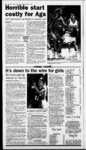
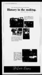
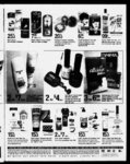
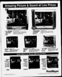
| Show D2 — The Herald Journal Logan Utah Sunday February 15 2004 Legal Notice Legal Notice Legal Notice Legal Notice Legal Notices Legal Noti Notices Mte? Legal Notices l NOTICE OF TRUSTEE'S SALE " highest bidder payable In (awful money of the United States at the time of sale at the East entrance to the First Judicial District Court at 135 North 100 West in Lo- at 11:00 am said day for the purpose dforectoeinL a Trtiat Deed originally executed by INC as Tiustors In favor LEWISTON STATE BANK which to Book 596 d Page 279 as Fling No 593017 in the cfrioodtfM Recorawd Cache County Utah coveting approximately 6939 acres and Unites TrustDeedwasrecordedJanuary251994 gipund In WtfttevBa C 106 106109 114 and 312 o( Sherwood Hills Condominiums Phase I located in VVMIsville Canyon (the undersigned disclaims liability for any error In the address description) and mors particularly described i The following described gan Cache County Utah on March 9 2004 i d WESTON-SHERWOO- d D d Legal Description attached The current beneficiary of the Trust Deed is LEWISTON STATE BANK and the record owners of the property as of the recordkig of the Notice of Default are OASIS INVESTMENTS TOGETHER with si the improvements now or hereafter erected on the property and al easements rights appurtenances now or hereafter attached to the property alas further described hi said Trust Deed without warranty as to title LPA UTAH LIMITED PARTNERSHIP rents royalties mineral offend gas rights and profits water water rights and water stock and The purchase price is payable In lawful money of the United States of America Bidders must be prepared to tender to the Trustee a $500000 cure bid ana the balance of the purchase price must be paid in fuff in the farm of certified funds or a cashier's check within 24 hours from the time of sale al fixtures deposit in certified funds or a cashier's check at the time of sale to se- DATED: February 6 2004 HICKMAN LAND TITLE COMPANY TRUSTEE PAT KLINGBERG SECRETARY Publication dates: February 8 2004 February 15 2004 February 22 2004 1 " LEGAL DESCRIPTION PARCEL 1: The West half and the West half of the Southeast Quarter of Section 17 Township 10 North Range 1 West of the Salt Lake Base and Meridian excepting therefrom 50 acres to Weffsvitle City in Book 167 Page 497 Also excepting the State Htyiway Also excepting therefrom the foliowing: Beginning at a point 5280 feet North and West 2625 feet from the South Quarter Comer of Section 20 thenoe North 544’ West 26432 feet thence North 151 East 93048 feet thence North 181430" East 142453 feet thence North 5157 East 77726 feebthence North 811 O' East 79442 feet thence South 4003' East 42646 feet thence North SWff West 25851 feet thence South 5541’ Wrist 63323 feet thence South 5055’ West 63127 feet thence South 3017! West 66821 feet thence South 103(7 Wset 125696 feet thence South 12473(7 East 45952 feet thence West 235 feet thence North 825' West 61766 feet thence North 145430' East 144575 feet thence North 2813' East 48449 feet thence North 644230 East 87378 feet thence South 5625' East 14288 feet thence North 50253(7 East 28411 feet thence South 8033 West 71777 feet thence 8outh5915 West 50850 feet thence South 2413' West 49011 feet thence South 1508 WM 153626 feet thence South point of beginning 807 East 6031 feet thence West 21064 feet to the a point which Is locatsdNorth 29®2742" west 47391 feet from the South Quarter Comer of Section 20 Township IQ North Range 1 West and running thence North 2342 West 57892 feet thence I 891:45 feet thence North 151' East 93048 feet thenoe North 18143(7 East 142453 feet thence North 5157 East 77726 feet thence North 811(7 East 79442 fret thence South 4603 East 42646 feet thence South 5055 West 63127 feet thence North 5020 West 25851 feet thence South 5541 West 63323 feet thence South 3017 West 66821 feet thence South 1030 West 125696 feet thence South 124730 East 144087 feet thence North 3802 East 81983 feet thence South 5149 East 30652 feet thence South 3802 West 45709 feet thence South 434930 west 44994 feet thence North 483(7 West 50 feet thence South 8956 West 31626 feet thence North 1237 West 11579 fest thence North 825 West 68336 feet thence North 14543(7 East 144575 tost thence North 2817 East 48449 feet thence North 64423(7 East 86378 feet thence South 5625 East 14288 feet thence North 5(7253(7 East 28411 feet thence South 8(733 West 71777 feet thence South 5915 West 50650 feet thence South 2413' Wrist 49011 feet thence South 1506' West 153626 feet thence South 807 East 105533 feet thenoe South 1417 East 72985 feet thence South 8950 Wrist 158 feet to the point of beginning PARCEL 2: Beginning at 544 west the Wrist half of the Northeast Quarter and the Southeast Quarter of Section 20 Township 10 North Range 1 Wrist excepting the following: The Southwest Quarter of the Southwest Quarter the 395830 in Book 197 Page 236) Less Goff Course State Highway and 18:18 acres to State of Utah by condemnation in Book 132 Page 3 Less Sherwood Hills condominium 4269 acres in Book 278 Page 850 Less Beginning North 292742 West 47391 feet from the South Quarter Comer of said Section 20 and thence North 2342 West 5789 feet thence North 544 Wrist 62713 feet to the North line of said Section thence East 20973 feet thence South 807 East 45152 feet thence South 1416’ East 72985 feet thence North 8956 West 158 feet to beginning LESS: Beginning 2148 feet Wrist of the North Quarter Comer of said Section 20 and running thence South 12473(7 East 96135 feet thence North 3802 East 81983 feet thence South 5149 East 30852 feet thenoe South 3802 West 45709 feet thenoe South 434930 Wrist 44994 feet thence North 4830 West 50 feet thenoe North 8956 Wset 31626 feet thence North 1237 Wrist 111579 feet thenoe North 825 Wrist 657 feet to the North line of said Section thence East to point of beginning LESS: Beginning North 131420 East 423 feet from the North Quarter Comer of Section 20 Township 10 North Range 1 West and running thence North 7930 East 281 77 feet thence South 1305 East 4757 feet to the South line of said Section 20 and running thence West 2413 feet thence North 1229 West 30549 feet thence North 3419 West 13742 feet to beginning LESS: ning thence North 1326 East 6126 feet thence North 3320 West 63855 feet thence South 5827 West 14257 feet thence South 1607 PARCEL 3: The Wrist half of riing s 1 West of the Salt Lake Base and Meridian described as fdtows: A part of Section 20 beginning at a point which is North 1902 I running thence South 8010 West 13865 feet thence North 2140 West 57869 feet thence North feet thence North 1700 West 672Q feet thence North 3020 Wrist 3040 feet thence North 424(7 Wrist 8960 feet thence South 4720 West 750 feet thence South 4(720 East 102127 feet thence South 112(r East 59117 feet thence South 3218 West 16537 feet thence South 3730 East 5200 feet thence South 3220 Wrist 15653 feet thence South 4313 East 63440 feet thence South 1020 East 50650 feet thenoe South 7520 West 19373 feet thence North 3640 West 8800 feet thence North 1145 Wrist 37813 feet thence North 3645' West 83189 fest thenoe North 2235 West 69441 feet thence North 0059 East 28351 feet thence North 1955' West 39600 feet thence North 3235 West 90835 feet by measure (90335 feet by record) thence South 4440 Wrist 21177 feet thence North 4320 Wrist 49943 feet thence North 4415 East 22600 feet thenoe North 8956 East 51626 feet thence South 4830 East 37500 feet thence South 3515 East 35200 feet thence South 3225 East 66318 feet thenoe North 7530 East 12415 feet thence South 1700 East 138445 feet thence South 8525 East 16817 feet thence North 7620 East 141 47 feet thence South 1440 East 70000 feet thence South 1151 East 62752 feet to the point of beginning PARCEL 4: Part of section 20 Township 10' North Range the Northeast Quarter and the Northeast Quarter of the Northwest Quarter of Section 29 Township 10 North Range 1 Wrist of the Salt Lake Base and Meridian Excepting the State Road Also Ex--1 24036 feet East of the North Quarter Comer of said Section 29 and running thence East 241 5 feet thence South 1305 East 38655 feet thence South 932 East 82425 feet thence South 8816 North 35151Wrist 921 3 test thence North 1607 Wrist 377 feet to the North line of said Section 29 thence East 30664 feet West 148 feet thence North 6533 West 206 feet thence North 5128 West 51406 thence South 13265 Wrist 1288 feet thence South 4408 East 102018 feet thence North 8053 East 7103 feet thence North 1926 Wrist 463 feet thence North 1229 Wrist 41951 feet to the North line of said Section PARCEL '5: The North half of cepting beginning at a point i thence East 241 3 feet to the point of beginning a point which is North 13142(7 East 4230 feet from the North Quarter Comer of Section 29 Township 10 North Range t West and naming thence North 793(7 East 28177 feet thenoe South 1305' East 86225 feet thence South 932 East 82425 feet thence South 8816' Wrist 14800 feet thence North 6533’ Wrist 20600 feet thence North 5128 West 51 4Q6 feet thence North 3515 West 92120 test thence North 1607 West 57720 feet thence North 5827 East 14287 feet thence South 3320 East 63855 feet thence South 1326 West 19006 (rife thence South 4406' East 102018 feet thence North 8053 East 7103 feet thence North 1926 West 46300 feet thence North 1229 West 72500 feet thence North 3419 West 13742 feet to the point of beginning PARCEL 6: Beginning at 108109 114 and 312 of SHERWObo HILLS CONDOMINIUMS PHASE I together with the undivided ownership interest in the Common Areas appurtenant to each respective unit and all other for Sherwood Hills Condominiums Phase 1 dated July 28 1968 and recorded in the official records of rights privileges and easements all as defined and described in that certain First Restated Declaration of Condominium Cache County State of Utah and that certain record or survey map referred to therein and as amended thereby ' PARCEL 7: All of Units 106 EXCEPTING therefrom all property as cfeweyed to Mark BaMf (Goff Course) and the property conveyed to Sherwood Resort Inc deacribed as fodcws: HiHs ' FOR MARK BALUF SHERWOOD HILLS GOLF COURSE PARCEL A: A parcel of fend situated in portion of Section 17 and 20 Township 10 North Range 1 : West Salt Lake Base and Meridian Cache County State of Utah more particularly deacribed as follows: Beginning at the Northwest Comer of said Section 17 Township10 North Range 1 West Salt Lake Base and Meridian thence along the North line of said Section 17 North 87530(7 East 264264 feet to the North Quarter Corner of said Section 17 thence along the East line of the northwest Quarter of said Section 17 South 00700" Wrist 42600 fest thence South 87530(7 Wrist 123391 feet thence South 183830" East 72959 feet thence South 25°05'0(7 East 51900 feet thence South 345300" East 13600 feet thence South 132100" East 32100 feet thence South 423000" East 9600 feet thence South 94600" Wrist 15300 feet thence South 42200(7 East Wrist 49150 feet thence North 66330 (7 West 18150 feet 35000 feet thence South 52410(7 West 61400 feet thence South 5(7013(7 Wrist 27400 feet thence South 45510(7 Wrist 56900 feet thence South 2652 thence South 52000" West 62000 feet thence South 5280(7 East 56700 feet thence South 86170(7 Wrist 7700 feet tfience South 0420(7 East 32550 feet thence South 5273(7 East 61000 feet thence South 2195(7 West 49500 feet thence North 302730" East 48700 feet thence North 381000" East 49800 feet thence South 52143(7 East 29700 feet thence South374200" West 49000 feet thence South 42330(7 West 49800 feeb thence South 41520(7 East 135900 feet thence South 173200" East 72700 feet thence South 20460(7 East 63750 feet thence North 85323(7 East 36100 feet thence South 12450(7 East 86100 feet thence South 80700" East 44600 feet thence South 78460(7 Wrist 13400 feet thence North 200000" West 517:00 fee thence North 15WOO" Wrist 59300 feet thence North 72150(7 Wrist 26250 feet thence North 25090(7 Wrist 11010 feet thence North 10490(7 West 38400 feet thence North 28260(7 West 17900 feet thence North 52250(7 Wrist 82700 feet thence South 43160(7 East 89000 Web thence South 10360(7 East 59650 feet thence South 37D4'(Xr West 17400 feet thence South 372800" East 51800 feet thence South 30150(7 Wrist 13900 feet thence South 44120(7 East 81650 feet thence South 9535X7 East 34900 fest thence South 4°17 0(7 West 20000 feet thence South 772300" West 14700 feet thence North 38450(7 Wrist 25800 feet thence North 64340(7 East 9100 frieb thence North 201330" Wrist 30400 feet thence North 34090(7 West 65000 feet thencri North 272000" West 76800 feet thence North 35530(7 East 16300 frieb thence North 192300" West 57250 feeb thence North 423200" West 31250 frieb thence North 360300" West 30900 thence North 54380(7 West 16900 feeb thence South 5418 00" West 18150 feet thence South 370330" East 6100 feeb thence South 14370(7 East 43250 feeb hence South 70070(7 West 15000 feeb thence North 17200(7 West 39600 feet thence North 442800" West 61 628 feet to the West line of said Section 20 thence along said West line of Section 20 North 02300" West 147656 feet to the Northwest Comer of said Section 20 thence along the West line of said Section 17 North 01100" East 52124 feet thence North 89200(7 East 19030 feet thence North 3300(7 West 96450 feeb thence North 90000(7 West 12707 feet to the West line of said - Section 17 thence along said Wrist line of Section 17 thence along said West line of Section 17 North 0110(7 East 85644 feet thence North 471000 East 29950 feebthence North 23170(7 East 102400 feeb thence South 6546 00" East 15400 feet thence North 263700" East 108700 feef thence North 154800" West 51824 feet thence South 875300" West 110307 feet to the West line o( said Section 17 along said West lne of Section 17 North 0110(7 East 42600 feet to the point of beginning W 1 Excluding therefrom the following parcel:-- Beginning at a point which bears South 49181X7 East 180964 feet from the Northwest Comer of Section 17 Township 10 North Range 1 West Salt Lake Base and Meridian thence from said point of beginning South 13110(7 East 60500 feet thence South 47130(7 East 33000 feet thencri South 36110(7 Wrist 38300 feeb thenoe South 301700" East 131 50 feeb thence South 51150(7 West 195Q0 frieb thence South 33190(7 East 30750 feeb feeb thence North 86420(7 West 10450 feeb thence South 131900" West 81200 feeb thence South 4305(7 East 82900 feeb thence South thencri South 560400" Wrist 72500 feet thence South 29490(7 West 442-0323 0(7 Wed 112100 feet thence South 86425(7 Wrist 5350 feet thence North 9125(7 West 50050 feeb thence North 1435(7 West 120400 feeb thence North 8145(7 East 32250 feeb tfience North 1250(7 East East 121065 feet to the 104900 feet thence North 60150(7 East 46000 feet thence North 29495(7 Wrist 41000 feeb thence North 23265(7 East 22950 feeb thence North 40135(7 East 24650 feeb thence North point of beginning-' ' 2545 - ' ' ' 4 : PARCEL B: A parcel of land situated in portion of Sections 20 and 29 Township ' ' ' r 1 West Salt Lake Base and Meridian lONorth Range ' '""i Cache County State - ' ' y of Utah more particularly described as fdtows: Beginning at a point which bears South 165846" East 1051955 feet from the Northwest Comer of Section 17Township 10 North Range 1 West Salt Lake Base and Meridkar thence from said point of beginning South 12305(7 East 77600 feet thence South 7285(7 East 500 feeb thence South 10475(7 East 48700 feet thence South 80245(7 Wrist 13850 feeb thence North 67395(7 West 13400 feeb thence North 46585(7 West 78350 feeb thence North 34145(7 West 70400 feet thence South 68415(7 Wrist 15100 feeb hence North 19335(7 Wrist 97700teet thencri North 55055(7 East 23450 feeb thence South 40545(7 East 38600 feeb thence South 694400" West 6900feeb thence South 24565(7 East 59600 feet thence South 491150 West 58 00 frieb thence South 38095(7 East 39250 feeb thenoe South 472650 East 86950 feeb thence North 171250 Wrist 60200 feet: thence North 12195(7 West 774Q0 feeb thence North 78490(7 East 24957 feet to the point of beginning 1 PARCEL C: A parcel of land situated in the Northeast " foHowst Quarter'd the Northwest Quarter of Section29 Township 10 North' Range 1 West Salt Lake Base and Moridtan Cache County State d d Utah more particularly dsscribed d as Section 29 Township 10 North Range 1 West Salt Lake Base and Meridian thence along the Wrist Kne said Northeast Quarter of the Beginning at the Southwest Comer of said Northeast Quarter otthe Northwest Quarter Section 29 North 180000" West 40000 feet thence North 89425(7 East 106908 feet thence South 1005(7 East 40000 feet to the South line said Northeast Quarter the Northwest Quarter Section Northwest Quarter 29 thence along said South line South 8942'50" West 1 08906 feet to the point beginning d d SHERWOOD HILLS RESORT ihiC in Real property situated PARCEL A: A parcel d ’ ' Cache Cdunty State of Utah arto more particularly described as fellows: d fend situated in the West half d Section 20 township 10 North flange 1 ' d l'1 : West d ' f Stilt Lake Base and d Mertdton Cache County State d Utah more particularly described as fdtows: Section 17 Township 10 North Range 1 West Salt take Base and Meridian thence from said point Beginning at apoint which bears South 90656" East 764428 feet from the Northwest Comer Ead 57200 fecit thence South 34535(7 West 163P0 feeb thence South 27205(7 East 23856 feeb v d beginning South 19235(7 d beginning d thence South 6831 5(7: West 53647 feeb thence North 23413(7 Wrist 89700 tost thence North 68315(7 East 70550 feet to toe point Togetherwith and subject to anyand all rights duties obligations easements andor rights recorded in the Office d the Cache County Recorder Stated Utah d way Contained in that certain Declaration r I therefrom the foregoing description any and all real properly and the improvements located thereon which ie contained with the condominium project defined and deacribed in that certain First restated Declaration Excepting ' Cache County Stale Utah which real property ia more particularly dsacrfbed as the fdtoaring tour paresis: Condominium (Or Sherwood HiHs condominiums Phase 1 dated July 28 1968 and recorded in ttte official records d d d v PARCEL NO !: Beginning at a point Iying 215213 feet North and 150155 feet West d ttie South Quarter Comer d Section 20 Township IQ North Range l Weat and running thence North 233043 West 1201 feeb thence North 66291 7" East 480 feebthence South 233043" East 1201 feet thence South 662917" West 485 feet to the point d beginning Weat Salt Lake Baas and Me PARCEL NQ: 2 Beginning at a point tying 220296 feet North and 138158 feet West d the South Quarter Comer d Section 20 Township 10 North Range l ana runrano ranoi Nom I deacribed above ' 233043" West 1525 feeb thence South 682917" West 9400 feeb thence South 234043" East 15250 feet tfience North 62917" East 9450 feat to the poHd beginning tossany portion d PARCEL NO 3: Beginning at a point lying 211050 feet North MKl162370feet West from the Soutfi Quarter Comer d Section 20 Township 10 North Range Waal and mining tfience North 2724'44" Waal 705 feeb tfience - L 1 I I 1 South 623516" West 9000 feet thence South2724'44" East 700 feel tfience North6235'16" East 90Xfeeb to tie ppintd baginning d Section 20fewnship 10 North Range PARCELNO 4: Beginning at a point lying 144758 feet West and 277758 feet North from the SouthQuartar Corner North 193349" West 1200 feet thenceNorth 702611 "East 1250 feet tfience South 193349r East 1205 feet to the point beginning d d Transportation in Warranty Deed executed July 27 d lie Recotdwd Cache Cbunly Utah THEREFROM that portion deeded to ihe Utah Stale Departmenl August 19 1992 as FingNfc 562759 in Book 534 Page 253 in w office EXCEPTING y ' 104714106 104714106 104714109' 104714114 104714312 ’"V - ' V ! I is - PuNcatfon Date: February 8 15 6 22 Weah and running lienee Soutfi 702611" West 1255 feeb tfience 1992 by Sardtoe Canyon Devetopment Inc: to Utah Dspertment ’ 100534010-'- 1 2004 r V d Transportatfon Recorded |