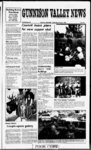
| Show m Iiiffyir NOTICE OF TRUSTEE’S SALE The following described property will be sold at public auction to the highest bidder payable in lawful cash money of the United States at the time of sale at the West front door of the Sanpete County Courthouse at 160 North Main Street in Manti Sanpete County Utah on October 24 995 at 0:00 am of said day for the purpose of foreclosing a trust deed executed by AS INDIVIDUALS Val Jean Hansen & Miriam D Hansen (aka Meriam Hansen) his wife Mariel 0 Hansen & Etta Mae Hansen his wife Stephen L Hansen & Janet L Hansen his wife and LaRell C Hansen & Debra Lee P Hansen his wife and Hansen Dairy Inc a Utah as TRUSTORS in favor corporation of the United States of America formerly acting through the Farmers United States Home Administration Department of Agriculture as TRUSTEE for the benefit and security of the United States of America as BENEFICIARY dated June 25 1986 and recorded June 27 1986 in Official Book 271 Pages Records of Sanpete County covering real property located in Sanpete County Utah and more particularly described as: See Exhibit ‘A’ attached hereto and made a part hereof The real estate will be offered for sale under two methods In the first method Parcel Nos 2 7 8 and 0 will be offered for sale as a single tract (“Tract 1’) with 212 shares of Gunnison Irrigation Company Water Stock and appertaining sprinkler system Parcel Nos 3 4 5 6 9 and 1 will be offered for sale as a single tract (“Tract 2“) with 400 shares of Gunnison Irrigation Company Water Stock and appertaining sprinkler system Parcel No 12 will be offered for sale as a single tract In the second method (“Tract 3”) Tract Tract 2 and Tract 3 will be offered for sale as a single combined unit The final sale will be closed using the method that yields the highest overall bid price for the offered property The United States of America as Beneficiary plans to bid for the real property water rights and appertaining sprinkler system as follows: Tract 1:512374182 Tract 2:516943657 Tract 3:5 2422636 Tract 1 Tract 2 and Tract 3 19 South Range 1 East Salt Lake Meridian ALSO beginning 5 chains West from the Northeast Comer of the Northeast Quarter Section 27 East Township 19 South Range Salt Lake Meridian thence West 202 chains South 28 deg 501 West2686 chains South 1615 chains East 20 chains North 20 chains West 5 chains North 20 chains to point of Less 314 acres to Raibeginning EXlway Containing 9158 acres CEPTING THEREFROM beginning 5 chains West of from the Northeast Corner of the Northeast Quarter 19 South Section 27 Township East Salt Lake Meridian Range thence West 3332 fee South 28 deg 501 West 177276 feet South 40650 feet to North side of Railroad Northeasterly along North line of Railroad 139250 feet North 989 feet to Containing 1821 acres beginning more or less Parcel 6: Southwest Quarter Section 26 Township 9 South Range 1 East' Salt Lake Meridian Containing 160 acres 7: Beginning 2020 chains Parcel West Northeast Corner Section 33 East Township 19 South Range Salt Lake Meridian thence South 1110 chains North 89 deg West 1140 chains North 1 deg East 1090 chains East 1120 chains to ALSO beginning point of beginning Northeast Corner Northeast Quarter Section 33 Township 19 South Range 1 East Salt Lake Meridian thence West 20 chains South 1075 chains East 20 chains North 1075 chains to point of beginning Containing 3393 acres Parcel 8: Beginning Northwest Corner Section 34 Township 19 South Range 1 East Salt Lake Meridian thence South 1045 chains Northeast on a curve along DRGW Railroad 1385 chains West 9 chains to point of beginning Containing 470 acres Parcel 9: Beginning 2875 chains South 50 chains deg West Northeast Corner Southeast Quarter Section 27 Township 19 South Range 1 East Salt Lake Meridian thence South 11 deg West 1830 chains South 74 deg 301 West 1650 chains North 14 deg 301 East 1053 chains North 46 deg East along West side of D&RGW Railroad Right of Way to point North 88 deg West 345 chains of beginning South 88 deg East 345 chains to beginning Containing 1959 acres Parcel 10: Beginning Southwest Corner Southwest Quarter Section 27 Township 19 South Range 1 East Salt Lake Meridian thence North 1090 chains North 88 deg 301 East 2020 chains South 43 chains to Railway Southwest along Right of Way to Section Une West to point of beginning West Containing 1809 acres Safina SunGunnlson Valiev News Wednesday October 4 1995 Paoe Parcel 11: Beginning Southeast Corner Southwest Quarter of Northeast 117500 feet thence South 62500 PUBLIC NOTICE feet thence East 69500 feet thence Section 27 Township 19 Quarter The Town of Centerfield will hold a South 2500 feet to the point of beginSouth Range East Salt Lake MePublic Meeting to hear citizen comridian thence West 781 chains to ning Containing 112 acres more or ment on a proposed change to the less RGW Railway North 45 deg 331 Zoning Ordinance 1975 The change East 1090 chains South 771 chains Together with 783 shares of Water would allow a Umited number of aniin ComStock the Gunnison Irrigation to point of beginning Containing 301 mals with in the CommercialResi-dentiacres pany Zone Parcel 12: Beginning 875 chains Together with al the improvements Al those interested are invited to West South 11 deg West 19‘ 80 and appurtenances thereunto belongattend the Public Meeting at the chains Northeast Corner Northwest ing or in anywise appertaining thereto Town Hall on October Centerfield including the water and water rights Quarter Southeast Quarter Section ditch and ditch rights belonging to the 27 Township 19 South Range 1 101995 at 8:1e5 pm It is located at above and foregoing described tracts 130 South Main If you have any East Salt Lake Meridian thence ofland Including but not Umited to 783 South 74 deg 301 West 300 feet please caH Debbie at the questions shares of water in the Gunnison IrrSouth 15 deg 301 East 150 feet above number North 74 deg 301 East igation Company Posted and Published this 25th day Published in the Gunnison 50 feet South 15 Deg 301 East 170 Valley 1995 of September News on September 27 October 4 feet North 74 deg 301 East 250 feet sDebra L Hansen Town Clerk 11 1995 North 15 deg 301 West 320 feet to in the Gunnison Published Valley beginning Containing 2 acres News on Sept 27 & Oct 4 1995 EXCEPTING THEREFROM THE SECTION 00010 INVITATION TO BIO CENTERFIELD TOWN SPRING FOLLOWING DESCRIBED RIGHT REDEVELOPMENT PROJECT ISM OF WAY as follows: of the Centerfield sealed bids for the construction Town Spring Redevelopment Separata Beginning at a point 60000 feet West and read 1995 wll be received by Centerfield Town Bids wil be publicly opened Project of the Southeast Comer of Section Utah A 5 aloud at 3 pm on Monday October 30 1995 at 130 South Main Centerfield 27 Township 19 South Range 1 East bid bond is required of the Salt Lake Base and Meridian and are Inc Plans and specifications have been prepared thence West 72000 feet to Quarter by Sunrise Engineering available at their office at 25 East 500 North FMmore Tel: Utah 84031 upon Section Une thence North 62000 feet Dollars (33500 for each set receipt of more or less to a fence comer thence This project includes of Centerfield's the complete redevelopment existing culinary water South 71 deg 351 West along said This entails excavation of the spring site exploration of the water bearing supply spring fence 114500 feet thence North 72 deg 301 West 7000 feet thence strata and redevelopment wfih a new system of colection pipe and box concrete culofi wal with bentonle clay drain gravel liner chain link fencing and reseeding polyethylene North 17 deg 301 East 2500 feet cost Estimated is 170000 project thence South 72 deg 301 East Paralltour will be held on Monday at A October 23 1995 pm leaving from the el to and 2500 feet Northerly of the tour is at the Centerfield Utah Attendance City Hall 130 South Main Centerfield said fence line 6000 feet more or less thence North 71 deg 351 East tnindltciy Rol wifi be taken Published In the Gunnison Valey News on October 4 11 18 40474 171 shares of Gunnison Irrigation Company Water Stock will be sold the bid therefor by and separately the United States of America as Beneficiary will be 544200 per share Parcel No 12 (“Tract 3’) will be sold subject to a Mortgage executed by Stephen L Hansen and Janet L Hansen in favor of the United States of America dated April 26 1974 and recorded on same date in Book 173 Official Records of Pages Sanpete County as assigned The Gunnison Irrigation Company Water Stock sold with Tract 2 will be sold subject to a special assessment and indebtedness to the Gunnison Irrigation Company The sale will be made without covenant or warranty regarding title possession or encumbrance to satisfy the obligations secured by and pursuant to the power of sale contained in the trust deed There may or may not be outstanding taxes or water assessments which would not be extinguished in this foreclosure sale Notice of Default and Election to Sell said real property was recorded in said Official Records on August 91994 in Book 355 Pages Dated this 20th day of September 1995 UNITED STATES OF AMERICA By: sJohn A Morgan JOHN A MORGAN Title: District Director Rural Economic and Community Development State of Utah United States Department of Agriculture EXHIBIT “A“ Parcel 1 Beginning Southeast Corner Section 28 Township 19 South Range 1 East Salt Lake Meridian thence North 1090 chains South 88 deg 301 West 1120 chains South 635 chains North 89 deg West2020 chains South485 chains East 3120 chains to beginning Containing 21 30 f No fine print No asterisk No disclaimer There is a time limit though Its only free for the next one hundred years with an opening deposit of one hundred dollars Is that a problem? acres Parcel 2: Beginning 1126 chains chains North from SouthSoutheast Quarter Section 28 Township 19 South Range East Salt Lake Meridian thence North 89 deg West 2020 chains North 545 chains North 88 deg 301 East 2020 chains South 635 chains to beginning Containing 1195 acres Parcel 3: Southeast Quarter of Southeast Quarter Section 27 Township 19 South Range 1 East Salt Lake Meridian Containing 40'acres EXCEPTING THEREFROM beginning at a point 25000 feet West of the Southeast Comer of Section 27 Township 19 South Range 1 East of the Salt Lake Base and Meridian thence West 35000 feet thence North 25000 feet thence East 35000 feet thence South 25000 Confeet to the point of beginning taining 201 acres more or less Parcel 4: Beginning Northeast Corner of the Northwest Quarter Southeast Quarter Section 27 Township 19 South Range 1 East Salt Lake Meridian West 875 chains South deg West 1980 chains East 1238 chains North 186S chains to beginning Containing 2031 acres Parcel 5: Northeast Quarter of Southeast Quarter Section 27 Township West 430 east Corner Its a personal account called Centennial Checking And this is the onlyplace you can get it Isn't it time you switched to Zions? ZIONS BANK Mimbcr FD1C Official sponsor of the Utah Centennial 25 1995 |