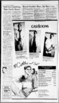
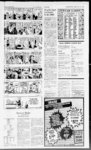
| Show ‘yJayr 2B The Salt Lake Tribune Friday June ijr'H) "ly 1impliWjMI nyyniiiympwyi iHTiurng- irtiiijiLi(jpriiijiitirfrii-fTf- i 12 1987 - v''-(‘- ' &4CVW 'j2a vj ’p $&- - txm Revolver bullets and money found on sidewalk are believed to have been dropped by fleeing robbery suspect after pursuing police challenged him to stop Officers Arrest 3 Suspects After SL Chase Shots Fired at Police Gang-Memb- er In addition to the robbery Thursday night on Argyle Court the men are suspects in a robbery earlier in West Valley City and “three or four” other armed robberies in West Valley and Salt Lake City during the past two weeks Late last week a joint task force was formed to investigate the robberies In the West Valley holdup Thursday afternoon three men forced their way into a home occupied by Cambodian refugees near 3100 South and 3800 West about 3:30 pm demanding cash and jewelry at gunpoint police said West Valley City Detective Ron Edwards said the three Oriental men g “mod” clothes wearing threatened the eight occupants of the home with handguns and herded them into a bedroom while the home was ransacked The victims told police the robbers spoke English to them and Vietnam Continued From B-- l shield and was thrown to the side walk where officers quickly handcuffed him The suspect was transported to LDS Hospital where he was treated for a head laceration and released into the custody of police The police car wound up with its hood buried in the entrance of the Cafe Trang a Vietnamese cafe at 820 S Main St The two other suspects were transported to the Metropolitan Hall of Justice where detectives were questioning them None of the four members of the Missouri family whose van was struck by the fleeing suspect vehicle was injured although they were “shaken up” said the mother Linda Gjvynn “Do you know the location of a good body shop?” she asked ruefully looking at the smashed side of their van “My poor son just keeps Saying he wants to go home” State Forecast loose-fittin- ese among themselves The bandits apparently had car trouble and had to push-stathe car described as a gray compact with a hatchback Lt Diamond of the city police department said that Officer Howell who initiated the chase was apparently unaware of the vehicle description from the robbery early Thursday “He was just suspicious of that car in that neighborhood” the lieutenant said “It had California plates It didn’t look like it belonged there” Detective Edwards described the bandits as “vicious” noting several of the victims had been assaulted and a shot was fired during one of the holdups “It’s only a matter of time before somebody gets hurt” he said Thursday’s holdups were the latest in a string of robberies in which investigators believe the men may be involved rt sr? -' vf H? x i r —Tribune Stall Photo by Tim Kelly Salt Lake police officer finishes hand cuffing one of three suspects on ground at A i I d Street following a chase in which shots were fired at police 800 S Main high-spee- Today’s Weather SBi - High pressure will dominate Utah's weather throughout the period The state forecast calls lor generally lair skies with isolated thundershowers mainly over the mountains through Saturday Unseasonably warm temperatures are expected with highs tn the upper 80s to mid OOs north and low 90s to near 100 south Overnight lows will be in the SOs to mld6fl The A ecu ftmcM for BPJi maty June 12 Expected Temperatures Selected forecast temperatures throughout the stole Ml Blanding 5390 Cedar City 5291 Greers River 5696 logon 5386 Moab 5895 Ogden 5887 Provo 5891 Salt lake City 5888 Vernal 5019 Wen-dove- r 6691 $t George 68101 Air Pollution Index pollution figures lot selected cities Souice —Utah Health Dept 0 excellent very good good above 100 marginal (OZ— ozone monoxide IP— total paniculants Soli lake 78 CO M City— OZ 85 CO 29 TP 46 Bountifut-- OZ M CO 29 Provo-- OZ M CO 44 Ogden-- OZ Air see? me Area Forecast Fridoy and Saturday Solt lake City Ogden and Provo: High will dominate the area's weather pressure throughout the period The forecast lor the metropolitan region calls tor mostly (air skies and unseasonably warm temperatures through Saturday Isolated thundershowers are expected neat the mountains mainly during the afternoon and evening hours light ond variable winds are expected except gusty near thundershowers High temperatures will be in the low 90s with overnight lows in the upper 50s and low 60s The chance ot measurable rain at Salt lake City is less than 20 percent through Satuiday Northern Utah Forecast — Wasatch Front Western Deserts Uinta Basin and Cache Valley High pressure will dominate the weather throughout the period The forecast (or northern Utah calls tor mostly (air skies ond quite worm temperatures through Sunday Isolated thundershoweis over ond near the mountains aie expected mainly during (he afternoon and evening hours There will be light and variable winds except strong and gusty near thundershowers Highs will be in the upper 80s to low 90s in the Wasatch Front and Uintah Basin with overnight lows in the upper 80s to low 90s The Western Deserts will have highs in the low to mid-90- s and overnight ‘lows in the mid and upper 60s Cache Val- - Wealher Summary Intermountain M— Missing T— Trace Yesterdays Conditions ley will be a little cooler with highs in the mid and upper SOs with overnight lows In the low to Southern Utah Forecast — Southwest mtd-50- s Valleys and Deserts Sevier Valfey Southeast Utah and Utah's Dixie: The forecast (or Southern Utah calls tor mostly lair skies and quite warm temperatures through Sunday Isolated thundershowers over and near the mountains ore expected mainly during the afternoon and evening hours light and variable winds are expected except gusty neor thundershowers Highs will range in the low to mid-90- s in most areas except in the upper 90s at Green River and in the low 100s ot Bulllrog and St George Overnight lows will be (torn the upper 50s to upper 60s Recreational Areas — lake Powell and Conyonlands — the forecast tor Utah's recreational oieas calls lor mostly lair skies with unseasonably warm temperatures through Satuiday There will be isoloted thundershoweis near the mountains moin-lduring the afternoon and evening hours Gusty winds die expected neor thundershowers otherwise winds at Lake Powell will be light and variable Highs at lake Powell will be near 100 with oveinigh! lows near 70 Conyonlands highs will bo in the mid and upper 90s with overnight lows in the upper y 50$ to low 60s Northern and Southern Mountains Utah’s mountain regions can expect (air to partly cloudy skies and unseasonably warm temperatures through Saturday There will be Isolated afternoon and evening thunder howers light ond variable winds are expected except strong gusty and shifting neat any shower activity Highs will be (tom the s s to with overnight lows (tom the upper 30s to upper mid-70- mid-80- 40s Daily Data TRACE Precipitation — Precipitation in June — 01 7 Accumulative deficiency — 023 Precipitation since Oct 1 1986 — 949 Accumulative deficiency — 272 1 00 at Hanksvillt Stale high — Stole low — 36 at Bryce Canyon S LC high — 07 degrees S I C low — 55 degree — Normal high tor this date 81 degrees Normal low for this date — 52 degrees Record high for this date — 96 degrees Record low lor this date — 40 degrees Sunrise Today — 5:56 MOT Sunset Today — 8:59 MOT Utah Agriculture Forecast: The agricultural forecast calls for mostly lafr skies and unseasonably warm temperatures with highs In the 90s through Saturday Nevoda Elko 13 83 Ely las Vegos Reno Wmnemucca Wyoming Evanston Casper Cheyenne Rock Springs la'amie 102 88 89 50 41 72 50 53 M 83 49 80 61 79 74 46 006 today's Forecast H M 41 Idaho Boise 94 60 Idaho toils 80 82 45 46 M 55 86 47 51 W Yellowstone 69 39 02 Colorado Denver Grand Junction 86 53 67 Poeoieilo Rexbmg twin foils Montana 91 I 45 45 73 62 55 60 52 54 84 83 60 68 89 80 74 69 67 70 WS ddy ptcl snny ptcl ptcl ptcl ptcl ckty snny Midwest lost 86 84 88 87 Be 91 89 67 65 69 63 68 64 55 88 71 snny ckty ptcl snny ptcl snny snny ptcl HOLLADAY 278-284- 6 4700 S HIGHLAND DRIVE SUGARHOUSE 484-878- 6 1033 3581 S MARKET ST 2100 268-060- 6 SOUTH OGDEN WEST VALLEY 966-138- 8 E 621-6353354 FASHION PLACE 0 HARRISON BLVD 1 55 EAST 6100 SOUTH OREM 225-775- 0 703 SOUTH STATE |