| OCR Text |
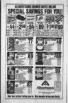
Show DAVIS NEWS JOURNAL, JULY 26, 1979 WEEKLY REFLEX ficial Zoning Map becomes damaged, destroyed, or lost, or difficult to in-- v terpret because of the na ture or number pf changes . ; KAYSVILLE CITY ZONING ORDINANCE No. 215 AN ORDINANCE ESTABLISHING COMPREHENSIVE ZONING REGULATIONS FOR THE CITY OF KAYSVILLE, UTAH, AND PROVIDING FOR THE ADENMINISTRATION, AND FORCEMENT, AMENDMENT THEREOF, IN ACCORDANCE WITH THE PROVISIONS OF TITLE 10, CHAPTER 9 OF THE UTAH CODE ANNOTATED, 1953, AS AMENDED, AND FOR THE REPEAL OF ALL ORDINANCES IN CONFLICT HEREWITH: WHEREAS 10, Title Chapter 9, Article 1, of the Utah State Statutes, empowers the City to enact a zoning ordinance and to provide for its administra- tion, and enforcement, amendment, and WHEREAS the City Council deems it necessary for the purpose of promoting the health, safety, convenience, order, and prosperity, general welfare of the present and future inhabitants of Kaysville City, to enact such an ordinance, and WHEREAS the City Council, pursuant to the provisions of Title 40, "Chapter 9, Article 2, Utah State Code, has appointed a Planning Commission to recommend the boundaries of the various original districts (zones) and an appropriate text reciting regulations to be enforced therein, and WHEREAS the Planning Commission has divided the City into districts and has prepared regulations pertaining to such districts in accordance with a comprehensive plan which is designed to lessen congestion in the roads and streets, to secure safety from fire, panic, and other dangers, to provide adequate light and air, to provide for the classification of landuses and distribution of land development and utilization, to provide protection of the tax base and to secure economy in governmental expenditures, to protect both urban and non-urba- n development, to prevent the overcrowding of land, to avoid either undue scattering or concentration of population to facilitate the adequate provision of transportation water sewerage, schools, parks, and other public requirements, and WHEREAS the Planning Commission has given reasonable consideration among other things to the character of the districts and their peculiar suitability for particular suitability for particular usps, with a view to conserving the value of buildings and land and encouraging the most appropriate use of land throughout the municipality, and WHEREAS the Planning Commission has marV a preliminary report and held public meetings thereon, and' submitted its final report to the City Council, and WHEREAS the City Council has given due public notice of hearings relating to zoning districts, regulations, and restrictions, and has held such public hearings, and WHEREAS lonlormity to all iv iuirements of Chapter 9 of the Utah State Code, with regard to the preparation of the report the Planning Commission and subsequent action of the City Council has been accomplished. NOW THEREFORE BE IT BY THE ORDAINED PEOPLE OF THE CITY OF KAYSVILLE, STATE OF UTAH: TABLE OF CONTENTS CHAPTER GENERAL 1 PROVISIONS CHAPTER 2 DEFINITIONS CHAPTER 3 ESTABLISHMENT AND DESIGNATION OF DISTRICTS S 4 CHAPTER RESIDENTIAL SUBURBAN R-- DISTRICT CHAPTER 5 l SINGLERESIDENTIAL FAMILY R-- . DISTRICT 6 - CHAPTER R-- ONE AND 2 RESIDEN- TWO-FAMIL- Y TIAL DISTRICT CHAPTER 7 R-- ONE AND 3 RESIDEN- - TWO-FAMIL- Y TIAL DISTRICT CHAPTER 8 R-- 4 MULTI- RESIDENTIAL FAMILY DISTRICT G-9 CHAPTER GENERAL COMMERCIAL C DISTRICT CHAPTER 10 CC CENTRAL COMMERCIAL DISTRICT CHAPTER USE CHAPTER FARM 12 ANIMALS CHAPTER 13 BOARD OF ADJUSTMENT AND AP-PEA- CHAPTER 14 ZONING AND PUBLIC HEARINGS CHAPTER TIONS AND EXCEPMODIFICA- 15 TIONS CHAPTER USES CHAPTER 17 CONDI- TIONAL USES CHAPTER 18 19 CHAPTER PARKING SPECIA1 the prior Official Zoning Map. The new Official Zoning Map may correct drafting or other errors or omissions in the prior Official Zoning Map, but no such correction shall have the effect of amending the original Official Zoning Map or any subsequent amendment thereof. The new Official Zoning Map shall be identified by the signature of the Mayor of Kaysville City attested by the City Recorder, and shall bear the seal of the City under the following words: This is to certify that this Official Zoning Map supercedes and replaces the Official Zoning Map adopted (date of adoption of map being replaced) as part of Ordinance No. of the City 6f Kaysville, Utah. Unless the prior Official Zoning Map has been lost, or has been totally destroyed, the prior map or any sig- OFF-STREE- T AND LOADING CHAPTER 20 SITE PLAN AND ARCHITECTURAL APPROVAL CHAPTER 21 SIGNS CHAPTER 22 MOBILE HOMES, MOBILE PARKS. AND TRAVEL TRAILERS CHAPTER 23 PLANNED UNIT DEVELOPMENT (PUD) EN24 CHAPTER FORCEMENT TIES AND PENAL- CHAPTER CONFLICTING MENTS, AND ODRINANCES, 25 AMEND- VALIDITY CHAPTER PROVISIONS 1 GENERAL SECTION EFFECT ORON PREVIOUS DINANCES AND MAPS The existing ordinances of nificant parts thereof be shall remaining Kaysville City covering the zoning of areas auu districts in the City in their entirety and including the maps heretofore adopted and made a part of said ordinances, are hereby superseded amended to read as set forth herein; provided, however, that this ordinance, including the. attached maps, shall be deemed a continuation of previous ordinances, and not a new enactment, insofar as the substance of revisions of previous ordinances is included in this ordinance, whether in the same or in different language; and this ordinance shall be so interpreted upon all questions of construction, including but not limited to questions of construction, relating to tenure of officers and boards established by previous ordinances and to questions of conforming or uses, buildings or structures, and to questions as to the dates upon which such uses, buildings or structures became conforming or SECTION. IN- TERPRETATION In interpreting and applying the provisions of this or- dinance, the requirements contained herein are declared to be the minimum requirements for the purposes set forth. SECTION CONFLICT This ordinance shall not nullify the more restrictive of covenants, provisions agreements or other ordinances or laws, but shall prevail notwithstanding such provisions which are less restrictive. SECTION OFFICIAL ZONING MAP Official Zoning Map The City is hereby divided into zones, or districts, as shown on the Official Zoning Map which, together with all explanatory matter thereon, is by adopted hereby reference and declared to be part of this ordinance. The Official Zoning Map shall be identified by the signature of the Mayor of Kaysville City, attested by the City Recorder, and shall bear (he seal of the City under the following words: This is to certify that this map is the Of- ficial Zoning Map referred to in Chapter 1 of Ordinance No. of the City of Kaysville, Utah, together with the date of the adoption of this ordinance. If in accordance with the provisions of this or- dinance and Chapter 9, Utah State Code, changes are made in district boun- daries or other matter portrayed on the Official Zoning Map promptly after the amended has been approved by the City Council, an entry shall be the City Recorder. No amendment to this ordinance which involves matter portrayed on the Official Zoning Map shall become effective until after such change and entry have been made on said map. No changes of any nature shall be made in the Official Zoning Map of matter shown thereon exthe cept in conformity-witprocedures set forth in this ordinance. Any unauthorized change of whatever kind by any person or persons shall be considered a violation of signed by and ordinance this punishable as provided under Chapter 24 of this ordinance. of tfie existence of purported copies of the Official Zoning Map, which may from time to be made or time published, the Official Zoning Map, which shall be located in the office of the City Recorder, shall be the final authority as to the current zoning status of land areas and of buildings and other structures in the Replacement of preserved together with all available records pertain- ing to its adoption or amendment. The City Council may have two official maps made, one to be kept in the vault, and one working map. and City. 16 Council may by resolution adopt a new official Zoning Map which shall supersede PROVISIONS APPLYING TO PARTICULAR USES Regardless LIGHT 11 . and additions, the City .7. Of- ficial Zoning Map. In the event that the Of SECTION RULES FOR INTERPRETATION OF DISTRICT BOUNDARIES Where uncertainty exists as. to the boundaries of districts as shown on the Official Zoning Map, the following rules shall apply: Boundaries in- dicated as approximately following the center lines of roads or streets, highways, or alleys shall be construed to follow such center lines. Boundaries in- dicated as approximately following platted lot lines shall be construed as following such lot lines. Boundaries in- dicated as approximately following city limits shall be construed as following such city limits. Boundaries indicated as following railroad lines shall be construed to be midway between the main tracks. Boundaries in- dicated as approximately following center lines of streams or canals shall be construed to follow such center lines. Boundaries dicated as parallel to or in- extensions of features indicated in Sections above shall through be so construed. Distances not specifically indicated on the Official Zoning Map shall be determined by the scale of the map. Where physical or cultural features existing on the ground are at variance with those shown on the Official Zoning Map, or in other circumstances not covered by Sections through above, the Planning Commission shall interpret the district boundaries. Where a district boundary line divides a lot which was in single ownership at the time of passage of this ordinance, the Board of Adjustment may permit, as a special ex- ception, the extension of the regulations for either portion of the lot not to exceed fifty (50) feet beyond the district line into the remaining portion of the lot. CHAPTER 2 DEFINITIONS EXPLANASECTION TION Unless the context requires the principal building or use. Garden sheds, storage shelters, and covered patios' not, equipped for use as mg quarters are acces- buildings. : Agent or Owner. Any person who can show upon request that he is acting for the property owner. Agriculture. The tilling of the soil, the raising of crops, liv-- V. horticulture and fur plants, s.ngular number shall include the plural, and the plural, the singular; the word building" shall include the word structure," the word include shall arranged, designed, constructed, altered, converted, used rented, leased, or intended to be used, and the word shall is mandatory and not directory. Whenever any of the lollowing terms are used, it shall mean the corresponding official, department, or commission of Kaysville City, Utah, herein referred to as the City: Mayor, City Council, City Recorder, City Planning Commission, Building Inspector. Zoning Administra- tor. In each case the term shall be deemed to include an employee of any such officer or department of the City who is lawfully authorized to perform any duty or exercise any power as his or its representative or agent. Accessory Use or Structure. A use or structure subordinate to the principal use of a building or principal use on the same lot, and serving a purpose customarily incidental to the use of repairs performed of a or minor (Section major (Section type, except replacement of plugs, lights, fan belts, and other small parts. Basement. A story whose floor is more than twelve (12) below inches the average level of the ad- joining ground, but where no more than (2) of its farms, one-ha- height is below the average contact level of the adjoining ground (as distin- uses. Alley. A public less than thoroughfare twenty-si- cellar.A Ef- Apartment, dwelling unit in a building height measurement y for and as a purposes of side-yar- d determination. Condominium. The ownership of a single unit in a multiunit project or structure together with an undivided interest in common in the common areas and facilities of the property. half-stor- u consisting of not more than one (1) habitable room, together with cooking and sanitary facilities. Beginning of Construction. Demolition, elimination, and removal of an existing preparatory structure to new construction,' or the incorporation of labor and materials in the foundation of a building or buildings. Court. An open, unoccupied space, other than a yard, on the same lot with a building or group of buildings, and which is bounded on two or more sides by such building or buildings. Boarding or Lodging House. A dwelling or part thereof where meals andor lodging are Coverage. The percent of the total site area covered by provided, for compensation, for three (3) or more structures other than persons, other than of members the those excepted in this ordinance. Crop and Tree Farming. The raising for commercial purposes of any field crops or wholesale nursery or greenhouses resident family. Building. Any structure having a roof supported by column or walls, used or intended to be use'd for the shelter or enclosure of persons, animals, or property. Building Height. The vertical distance from the average finished grade surface of the building to the highest point of the coping of a flat roof or to the deck line of a mansard roof, or the mean height level between eaves and ridge for gable, hip or gambrel roofs. including necessary buildings incidental to such crop, but not including a building for retail sales. Dairy. A commercial establishment for the and manufacture packaging of dairy products. Distance Between Residential Building, Main. building in which is conducted the principal use of the building site on which it is situated. In any any dwelling shall be deemed to be a main building on the building site on which it is District. the territory of Kaysville City within which certain uniform regulations and requirements of various combinations thereof apply under the provisions dinance. private road, the use of which is limited to persons residing, employed, or otherwise using or visiting the parcel on which located. Dwelling. Any building or portion thereof designed or used exclusively as the Use'.-- use which would residence or sleeping place of one or more persons, but not including a tent or trailer. Dwelling. Condominium. compatible through the and maintenance of qualifying circumstances, as provided in Chapter 17. Apartment Ho- A dwelling whose ow- nership conforms with tel. Any building which contains dwelling units Section Dwelling, building designed for or used exclusively as a ri,,;iilcncc by one Apartment Dwelling, replacement of parts passenger cars and trucks not exceeding one and (li) one-ha- lf tons capacity, but not including other operations, named under Automobile Repair Major; or similar thereto as determined by the Building Inspector. Automobile or Trailer Sales Area. An open area used for display, sale or rental of new or used motor vehicles, trailers, or mobile homes in opera- - ble condition, and where no repair work is done. Automobile Service Station. A place where gasoline, or any other major fuel or lubricating oil or grease for operating motor vehicles is offered for sale to the public and deliveries are made Garage, Public. building or portion A thereof, other than a private garage, designed or used for servicing, repairing, equipping, hiring, selling, or storing motor vehicles. Grade. For building adjoining one (1) street only, the elevation of t.ie sidewalk at the center of that wall adjoining the street. For building admore than one (1) joining street, the average of the elevations of the sidewalk at the centers of all walls adjoining streets. For huildings having no walls adjoining the street, the average elevation of the ground (finished surface) Center. Group Day Care An establishment for the care andor instruction, whether or not for com- pensation, more than six (6) children. This definition includes child nursery facilities. and pre-scho- ol Home Occupation. A commercial activity conducted entirely within the dwelling unit, clearly incidental and secondary to the use of the dwelling for residential purposes, and in accordance with Section Hotel. See Motor Hotel, Section Household Pets. Animals or fowl ordinarily permitted in the hpuse and kept for company or pleasure, such as dogs, cats, and canaries, but not including a sufficient number of dogs or cats to constitute a kennel as defined in Section Junk Yard. The use of any lot, portion of lot, or tract of land for the long-terstorage, keeping, or abandonment of au- tomobiles, other vehicles, or machinery or parts thereof; provided, that this definition shall not be deemed to include such uses that are clearly accessory and incidental to any agricultural use permitted in the district, nor shall it apply to equipment storage. 2 144 Kennel. Any lot or premises on which three (3) or more dogs or cats (or similar household pets) at least (4) four months old are kept. or duplex. building designed for or used exclusively as a residence by two (2) families, living independently of one another. A Dwelling, Mul- Dwelling, d attached or building cona single taining dwelling unit and located on a parcel of land in one (1) ownership and having any yard or An semi-attache- public cupied by a principal building or a group of such buildings and accessory buildings, together with such open spaces as required by this ordinance, intended to be held in separate ownership or leasehold. 2147 Mobile Home. single family dwelling permanent dwelling poses. pur- Motor Hotel, Includ- ing Motel and Hotel. A building or group of buildings for the accom- court in common. Dwelling Group. group of two (2) or more detached buildings used as residences located on a parcel of land possibly having yard, access drive or court in common. Dwelling Unit. One (1) room, or suite, or two (2) or more rooms, designed for or used by one (1) family for living and sleeping. Family. An individual, or two (2) or more persons related of land on-- designed to be transported on its own wheels or on a trailer, to be placed on a site ready for occupancy except for minor unpacking or assembly and connection of utilities. 2148 Mobile Home Park. . A plot of ground upon which one or more mobile homes are located for more or less ui.Jmg or portion uk ivoI designed for or used exclusively as a residence by three (3) or more families, living independently of one another. Townhouse. House, Section 2146 Lot. A tiple by o conformity with applicable regulations, if any, at the time of its erection. (See v-41 Chapter 16.) 2152 Use; h A use of a structure or land which does not conform to the use regulations for the disin which it is situated, but which was in conformity with applicable regulations, if any, at the time of its erection. (See Chapter 16.) trict 2153 Office. modation of transient guests, comprising individual sleeping or living units. NATURAL Waterways. Those areas varying in width, along streams, creeks, springs, gullies, or washes which are natural drainage channels as determined by the Building Inspector or City Engineer. Structure. A structure which does not conform to the regulations for the height, coverage, or yards of the district in which it is situated, but which was in tention to or advertise, which is placed on the ground, on : any bush, tree, rock, wall,'. : .post, .fence, building, struc-- ; ture, vehicle, or any place. 5 whatsoever pnd which is visi- -. ble from outside a building. shall The term "placed include constructed, erected, posted, painted; printed, . tacked, nailed, glued, stuck, carved, strung, or otherwise fastened, affixed, or made visible in any manner what- soever. (For further defini- tions, consult Chapter Office, Professional. A place intended for the conduct of a recognized learned profession in most cases requiring a license, such as physician, 2 168 Site Plan. description of the proposed development within the boundaries of the development site consisting of plans, drawings, and information as specified in Chapter 20. 2169 Stable. A detached building for the keeping of horses. 2170 Story. That portion of a building included between the surface of any floor and the floor or ceiling next above it. A 21532 Office, Business. place intended for the conduct of the administrative function of a business enterprise and in which no goods or merchandise are stored or sold. A 2154 Open Space, Usable. Usable open space shall be any portion of a lot, including the roof of a garage or carport not over eight (8) feet above grade, which is landscaped 21701 Story, Half. partial story under a gable, hip, or gambrel roof, the wall plates of A which on at least two (2) opposite exterior walls are not more than four (4) feet above the floor of such story; provided, however, that anjTpartial story used for one (1) or more dwelling units shall be deemed a full story. and developed for recreational use. Parking areas, service areas, and driveways shall not be deemed to be usable open space. Area, Parking Private. An open space for the same uses as a private garage. 2156 Parking Area, Public. An open area used for the parking of automobiles and to the public whether for a fee, free, or as an accommodation for clients or customers. 2157 Parking Space. 21, Signs.) dentist, chiropractor, lawyer, engineer, architect, accountant. 21702 Story, First. The lowest story or the ground story of any .building, the floor of which is not more than twelve (12) inches below the finished grade level at the exterior walls of the building, except that any basement or cellar used for residential purposes shall be deemed the first story. - available A permanently-surface- d area of not less than one hundred eighty (180) square feet in area, either within a structure or in the open, excluding paved areas necessary for access under the provisions of this ordinance, for the parking of a motor vehicle. (See Parking, Chapter 19.) which affords principal means of access to abutting property and is more than (26) feet wide. The twenty-si- x Development. avenue, drive, circle, road, Off-Stre- et Planned A Unit residential development guided by an integrated design in which one or more of the regulations, other than use regulations, of the district in which the development is situated is waived or varied to allow flexibility and initiative in site and building design and location, in accordance with an approved plan and imposed general requirements as specified in Chapter 23. 2159 Public Use. andor operated exclusively by a public A use owned body, or quasi-publi- c body, having the purpose of serving the public health, safety, or general welfare, and including uses such as public schools, parks, playgrounds, and other recreational facilities, administrative and service facilities, and public utilities. 2160 Public Utility. A public or quasi-publi- c agency, or its structures and facilities, established to provide water, power, gas, sewer systems, and other public services and who con- struct and maintain structures and facilities for their distribution or storage. 2161 A use non-prof- Quasi-Publi- c Use. operated by a private religious, recrea- or tional, charitable, philanthropic institution, such use having the purpose primarily of serving the general public, such as a church, private university, or similar use. 2162 Recreation, Commercial. facilities Recreation operated as a business and open to the general public for a fee. Recreation, Private, See Boarding or Lodging street, or approved private street, which may be oc- Dw"i" A ad- jacent to the exterior walls of the building. All walls approximately parallel to and not more than five (5) feet from a street line are to be considered as adjoining a street. having mintage Mobile Home. As defined in Section Automobile Repair, Major. and motor service to on the lot. Apiece or parcela (1) family. Mul- Repair, Minor. Upholstering, storage of vehicles of persons occupying the main building Lodging House. A defined in Section service, A detached accessory building, or a portion of a main building, used, or intended to be used, for the Single-Famil- and also satisfies the definition of a hotel, as including body, frame, or fender repair, or over-al- l painting. Automobile Zoning Driveway. A become harmonious or collision this orIncludes and Zone room or space wholly under the surface of the ground, or having more than fifty (50) percent of its floor to ceiling height under the average level of the adjoining ground. Child Nursery. See Group Day Care repair, of District. A General Family Day Care. The keeping for care andor instruction, whether or not for compensation, of six (6) children or less within a dwelling, not including members of the family residing on the premises, Flag Lot. . A lot which meets all minimum size requirements for the zpne in which it occurs, but which exists mostly behind another lot, and which has access to a dedicated street by way of a projection (or staff) of at least thirty (30) feet width, and no greater than two hundred (200) feet in length. Garage, Private. A portion of Carport. See Dwelling, ties. structures as herein See Garage, Private, Section Cellar. House. : defined. located. application ; blood, marriage, or adoption, or a group of not more than four X4) persons (excluding (servants) who are not related, hving in a dwelling unit as a single housekeeping unit and using common cooking facili- Structures. The shortest distance between the vertical walls of two residential A Center, Section Conditional Section basement shall be counted as a story for purposes of ficiency. multi-famil- y a from guished x (26) feet wide. A lf floor-to-ceili- nurseries, or similar rebuilding or reconditioning of engines, motor vehicles or trailers, this ordinance. automobile washing, and not to include animal hospitals, plant Words used in the present tense include the future, the of " gar- the following definitions shall be used in the interpretation and cons- truction 1ng storage . of merchandise, lubricating of automobiles, and - f dening, but not including the keeping or raising of farm animals and fowl, except household pets, and not including any agricultural industry or business, such as fruit packing tiple, Section otherwise, directly into motor vehicles, and where , , services are performed "J:. to include tube and tire V repair, battery charg- - ' Clubs or recreational facilities, operated by a organization and open only to bonafide members of such it organization and their guests. 2164 Recreation, Public. Publicly owned or operated recreation facilities. 2165 Residential Density. The average number of families living on one (1) acre of land in a given area. Net residential density is determined by dividing the total number of homes or families in a defined area by the total acreage of all parcels of land within the area that is used exclusively for residential and accessory purposes. Gross residential density is obtained by dividing all land in a defined area used for non-prof- non-prof- residences, streets, local schools, local parks, and local shopping facilities, into the total number of families in said area. 2166 School ot General Instruction. Any public or private elementary, junior high, high school, college, university, or school offering courses in general instruction at least five (5) days per week and seven (7) months per year. Excluded are specialty schools such as trade, dance, beauty, music, secretarial-businesand charm s, schools. 2 167 . Sign. writing, representation, pictorial symbol, banner, lighting fixture, or any other figure of similar of whatever character material which is used to identify, announce, direct at Any 2171 Street. A public thoroughfare term street shall include parkway, boulevard, high- way, thoroughfare, or any other similar term. 2 172 Street, Private. y A or easement in private ownership, not dedicated or maintained as a public street, which affords the principal means of access to two (2) or more sites. right-of-wa- Structural Alterat- ions. Any change in the supporting members of a building, such as bearing walls, columns, beams, or girders. 2174 Structure. Anything constructed, the use of which requires fixed location on the ground, or to is attached which something having a fixed location upon the ground, and which imposes an impervious material upon or above the ground. 2175 Swimming Pool. A structure, whether in- doors or outdoors, or whether above or below the ground, intended to be used to contain water, and which is of suf- ficient size, capacity; and depth for swimming. 2 176 Travel Trailer. . " A trailer used for sleeping by persons while travelling, but not intended as a permanent dwelling, and not constructed for permanent attachment to public utilities. 2 177 Travel Trailer Park. A plot of ground upon which one or more travel trailers are located temporarily while in use as temporary dwellings, whether or not for compensation. 2178 Unified Control. parcel of land under one ownership, or a group of parcels, the owners of which have agreed in writing to subject A the development of their properties to a single control. 2179 Yard, Front. An open space extending the full width of the lot measured between the front lot line and the closest main building, which open space is unoccupied and unobstructed from the ground upward except as specified elsewhere in this ordinance. Front Yard, Depth. The shortest distance, measured horizontally, between any part of the main building, other than parts herein excepted, and the front lot line. Such depth shall be measured from the front lot line, provided, however, that if the proposed location of the right-of-wa- y line of such street as adopted by Kaysville City Official Map differs from that of the existing street, then the required front yard depth shall be measured from the line of right-of-wa- y such street as adopted; or said building shall comply with official setback lines as adopted by the City. ; 2 180 Yard, Rear. An open space between a building and the rear lot line, unoccupied and unobstructed from the ground upward and extending across the full width of the lot, except as specified elsewhere in the ordinance. 21801 Rear Yard, Depth. The shortest distance, measured horizontally, between any part of a main building, other than parts |