| OCR Text |
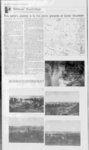
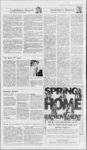
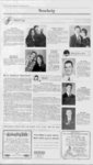
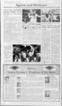
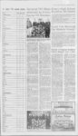
Show 5 . Williams Wandering's MarK H and Terry Williams, Progress guest columnists This weeks journey is to the picnic grounds at Cedar Mountain then the III folks' Before we begin our journey today, let me introduce my sell and my wile to you Ve live in Castle Dale, where we enjoy a small farm raising Suffjlk Sheep, a llama (to guard the sheep , peacocks lor fun and a few cows Mark is a native of Fmery County and Terry was raised m (Star Valley Wyoming Exploring tor Indian rock art and other his- torical sites, photography, camping and our more active hobbies This has evolved into us being partners m a guided tour business We enjoy their volunteer work with civic organizations such as the Fmery County Historical Society and the San Rafael Roundup Mark is also on the board of the Museum of the San Rafael and involved with Heritage InATV mg are a few of dustries We show slide presentations of the San Rafael Swell and Utah Anasazi Indians to Utah History classes in schools and other public groups Mark's talent with photography is displayed in he and Owen McClenahan s book, Utah s Scenic San Rafael Scouting is another hubby that is very to Mark He is the Buckhom District Advancement Chairman for the agle Scouts and is pleased to be able to work with the young men and their parents in achieving their goals Other positions held by Mark are Chairman of the Utah Parks and Recreation OHV Advisory Council and President of SouthEastem Utah OHV Club Our journey today is going to be a fun one for the whole family We re gouig to end up at the picmc grounds on Cedar Mountam Load up a picmc lunch and the family for a great and exploring From the day of point of Cedar Mountam there is a great view' of the interesting locations w e traveled m previous Williams Wanderings. Well leave Castle Dale by traveling north and turning nght at the old corrals north of town and travel east 16 miles to the Buckhom Junction Turn north (left) to take the road towards Buckhorn Reservoir Well pass a road to the left that leads to Huntington but continue on to the next junction the left road leads to Cleveland straight ahead goes to the Dinosaur Quarry-t- he right (the one we take) leads to Cedar Mountam If you live closer to Huntington, you can take the road north of Huntington at the sign that says Dinosaur Quarry It wall lead you through Cleveland to the junction that says Dinosaur Quarry or straight ahead to Cedar Mountam Watch for antelope as you travel along They are usually sighted along this area. Well travel lin-porta- nt fc sight-seein- g across Grease wood Hat and begin climb up the mountain Most of the tune well be gomg along Bull Hollow Soon well be going across Wunmer I lat Sometimes there is a herd of elk along here As we contmue on up the mountain, well draw near the edge. Look out of the south (nght) side of your car and see a good portion of the San Rafael Swell As we near the top, we can spot the communication microwave tower station (well visit it later) When we come to the view area stop and walk over to it and read the information signs There is a great view of the San Rafael Swell from here Hopefully you have your camera to get some beautiful shots of the country Right below is Buckhorn Draw, Calf Canyon and Wmdow Blind Peak Look to the nght to see the towns of western Emery County In the distance are the Henry Mountains, Abojo (Blue) Mountains and the LaSal Mountains. These mountains are close to Hanksville, Monticello and Moab Take some time to explore up here for a little while. Well retrace our steps and go on to the next view area where there are some more information signs, restrooms and also the trail that leads to the Cedar Rim Picmc Site. Its a great place to explore and play among the rocks and pinion pmes. Enjoy your picnic lunch here as it is sheltered by the wmd and there are some mce tables and fire pits for your enjoyment. However, it isnt sheltered from the snow as shown by the photo accompanying this article Another highlight of this area is the nature trail that leads off from the picnic area Theres quite a bit of information to glean from this hike. From this second view area the old railroad grade, Spanish Trail, Star Mail Route and Captain Lonngs soldier trek can be visualized all the places featured in recent articles. Youll be able to see why this route with its easy access was chosen by them. The power line passes through about the same route hide-and-se- now. After lunch and the nature hike, return to your car and drive on up to the microwave tower station. Look over the edge to the east and see Chimney Rock and the Price River meandering through the Book Cliffs to the Green River. It feels like you are on top of the world1 We hope you have enjoyed your expenence with us today It is fun to spend a day where the whole family canjom m. Well see you again next time1 Mark and Terry Williams alkalis etv net 435381-2493 Clockwise from upper right corner: map depicting this weeks travel area, the picnic grounds spoken of in the article, and the remainder of the photos show the beautiful scenery you will see as you follow this weeks Williams Wanderings. i I 9 5 Ss ; i i i 4. t f I L, |