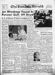
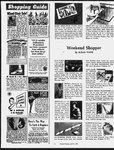
| OCR Text |
Show SA Sene im aeee: eeee Legal Notices NOTICE OF FINAL TAX SALE Notice is hereby given that on the 20ch day of May, 1964, at lu:00 o’clock A. M., at the west euwance of the County Court House in Provo, Utah County, Ucah, I will offer for sale at public auction and sell to the hignest bidder for cash, pursuant to the provisions of section 59-10-64, Utah Code Annotated 1953, as amended, the following described real estate situate in said county and now held by it under preliminary tax sale. No bid for less than the total amount of taxes, interest, penalty and costs which are a charge upon such real estate will be accepted. ALPINE CITY B 5 Alton R. Carlisle & Beryl Carlisle—Com. 105 ft N or SW cor of Blk 2, Plat A, Alpine City Survey: ,N 60 ft E 447.4 ft; S 17° 17 W 52.2 ft; S 17° 17’ E 94.6 ft; S 25 ft; W 35 ft; N 121.30 ft S 85° 09° W 160.76 ft; N 88° 27’ W 89.77 ft; S 89° 27° W 208.42 ft to beg. Total $48.01 B 39 C Beverly Rhodes—Com. 180 ft N of SE cor of Blk 8, Plat A, Alpine City Survey; N 6 ft; N 87° 13’ W 2.40 chs to school land; S 60 ft, mor 1, to pt directly W of beg; E 2.40 chs m or to beg. E 599 B 4 9 GrowInv. & Mtge. Co.—Lot 9, Blk 4, Plat B, Keyy Ridge Heights Subd. Totalipeencsveceeeeee $983.77 E 662 Alice J. Skinner — Com. 1967 chs W & 30.12 chs S from Utah County, Utah LEGAL NOTICE 43, 1.83 acres. Total $9.54 NEBO SCHOOL DISTRICT Unknown Owner c/o Steven A. Johnson — South Point Lithograph or Building Stone Quarry Placer Mining Claim, in T 10 S, R 6 E, SLM. 40 Ac. State Placer Mine No. 1, Lot CLASSIFIED DISPLAY Sunday Herald 11A LEGAL NOTICE SUNDAY, APRIL 19, 1964 | in the following list of abbrevi-| ations: BAC ress sees oes for acre, acres, add ..... . for addition! AVE ce.eee . for avenue| .. for beginning} beg ... bike a. for block NEcor of Sec 27, T 6S, R 2 bet ........,...00. for between E, SLB&M; W 33 lks m or | bdy, bdrs.... .. to. W line of E% of NE% of for boundary, boundaries No. 38, in Sec. 8, T7S, 23 E, sd Sec; N 12 chs; E 33 lks; ch, chs .... for chain or chains SLM. 60 ac. S 12 chs to beg. Area .40 of . for commencing Total $170.78 com .. an acre. Total $87.21 Unknown Owner c/o Steven A. (iil = he aaaeengen ae for continuing deg or ° for degree, degrees Johnson—Utah Mining District E 701 B Kenneth R. Allred & Caroline, Iot No. 37; Highland WO? coppoaodocsqoneans for corner Helen H., Gordon K., & Max. for distance Mary, Lot No. 38; Sarah Lot = = ine G. Allred—Com. 146.93 Pelirersiate sett an for east No. 39. 12.62 ac. ft E & 628.4 ft N 1° 58° W of . for easterly $27.28 By Total SW cor of Lot 35, Knight . for foot, feet subd; N 1° 58° W 24.6 ft; N|K 800 A Heber W. Clayson & ft .. {rae Sense . for fractional Hattie C. Clayson—Com. 10 88° 48’ E 214.76 ft; S 26.6 . for inch, inches 90 Ls. Mineral Surfaced, chs ‘N of SE cor of SW% ofli ft; S 88° 48’ W 88 ft; S 1° . for link, links Sec 18, T 8 S, R 2 E, SLM; 43.5’ W 628.40 ft; W along st Ceramic Chip. N 10 chs; W 10 chs; S 10 chs; Tteplisfeasenacteee. = for lot, lots 50 ft N 1° 43.5° W 628.4 ft; (Reg. as high as $6.00). Green, W 77.26 ft to beg. Area .82 E 10 chs to beg. Area 10 acres. m, min, or ’ red, white. 108-ft. rofl. Less Fixt. for minute, minutes Total $140.73 of an acre. Total et een oe $107.78 K 994 L. N. Edwards & Erma morl........ for more or less IN Rasiiicles seston. for north Edwards—Com. 15 rods W & PROVO CITY F 28 A Lee Ray Sorenson & 58 ft N of SE cor of SW%of INE Speers for northeast . for northeasterly SwW% of Sec. 28, T 9S, R 4 Fontella B. Sorenson—Com. Same as Thick Butts, except even thickness for longer — for northwest E, SLM; N 62.4 ft; W 52 ft; 50.76 ft W & 99 ft S of NE . for northwesterly life. (REG. AS HIGH AS 15.00 SQ.) .......... ae etes S 57.40 ft; S 86° 21’ W 53 ft cor of Lot 6, Blk 4, Plat A, eehseaeee # for point to beg. Area .08 of an acre. Provo City Survey; W 49.50 . for quarter section ft; S 100.69 ft; E 49.50 ft; Total) gene are $21.10 ... for range, ranges K 992 Cliff Howard—Com. 16.25 N 100.69 ft to beg. Seuiesoves for rod, rods Total .............0.. $15.01 chs E & 58 ft N of SW corof Less Fixt. F 282 Hannah Wilcox—Com. 6 Sec 28, T 9 S, R 4 E, SLM; R of W «...04. for right of way rods W of SE corof Blk 30, N 2.62 chs; E 2 chs; S 2.74 SOKeeneee for section, sections 45-lb. Plat A, Provo City Survey; chs; N 86° 21’ W 132 ft to beg. sec, secs .. for section, sections (Reg. $3.42) Ss for south W 3 rods; N 6 rods; E 8 rods; Area .54 of an acre. 55-lb. Saseoee for southeast S 6 rods to beg. Total .................. $25.42 (Reg. $3.87) ... for southeasterly Total ener ce caeeee $119.64 K 996 L. N. Edwards & Erma Total... es eeanes $15.43 ere for southerly 65-lb. Edwards—Com. 299% ft W & B 257 Robert Thomas Patter- F 802 Frozen Food Locker & ~ for street Service—Com. -at NW cor of 63 ft N of SE cor of SW% of son & Eudora J. Patterson— (Reg. $4.35) SuDW oe ee for subdivision SW% of Sec 28, T9S, R4E, Com. 480.4 ft N 89° 58 E of * Blk 68, Plat A, Provo City SLM; N 57.45 ft; W 68 ft; SLM .... for Salt Lake Meridian SW cor of NW% of NW% of Survey; E 49.985 ft; S 149.85 15 Ib. Felt $2.24 ft; W 49.985 ft; N 149.85 ft SE 53 ft; S 86° 21’ E 53 ft to SW ceca eocese for southwest Sec 19, T 4S, R 2 E, SLM; 326 Ft. Roll (Reg. $3.20) T, t, tp, tps .... for township to beg. beg. Area .08 of an acre. N 57° 11’ E 441.5 ft; N 50° 46’ Total ................ $563.91 Total’ eee eee $116.67 Cheer rem eene for thence E 231.6 ft; S 20° 28’ EB 111.1 ft; S 55° 08° W 265.5 ft; S F 1466 84 A Don K. Mignon L 1375 John Merl Tanner & U. S. Sur cscace for United States Survey Griffiths — Com. 926.40 ft Sarah D. Tanner—Com. 15.77 62° 22’ W 286 ft; S 89° 58 Z for West S & 1395.77 ft W of NE cor of chs W & 8.15 chs S 1° W & Wi ire W 117 ft to beg. Area 1.29 w-ly for westerly NW%of Sec. 36, T 6S, R 2 S 52’ W 62 chs of NE corof acres. IN WITNESS WHEREOF I E, SLB&M; N 15’ E 79.2 ft; SE% of Sec 7, T 9S, R2E, Totaly. von cec stacone $66.95 N 51° 45’ E 39.7 ft; along arc SLM; N 89° 9’ W 12.10 chs; have hereunto set my hand and AMERICAN FORK CITY official seal this 10th day of of curve to left (which has a S 36° 10’ W 14.08 chs; S 89° C 707 B Ray Rowes & Elaine radius of 40 ft. central angle 30’ E 6.35 chs; N 52’ E 7.29 April, 1964. Howes—Com. 342.2 ft E of of 65° the .chord of which JOHN R. MURDOCK chs; S 89° 30’ E 13.77 chs; N SW cor of SE% of SW% of bears N 7° 15’ W for 42.98 52’ E 3.97 chs to beg. Area UTAH COUNTY AUDITOR, See 13, T 5 S, R 1 E, SLM; ft) a distance of 45.38 ft; N 8.11 acres. UTAH N 32.64 ft; E 97 ft; S 32.64 ee aCe Pe De sie lce 64° 45’ W 80 ft; S 16° 15° W Total .................. $49.61 (SEAL) ft; W 32.64 ft to beg. Area .07 r 7%" blade. Here rsatility and Published in The Sunday Her-' 185.8 ft; S 88° 18° E 97.77 N 220 R. J. Rodgers — W% of features found tn saws t i ie:] a tO Ole) of an acre. ft m or | to beg. SE% of Sec 16, T 9S, R1 W, a April 19, 26, May 3, 10, 17,' Total $18.98 pecifications: Maximum ¢ at 90"; 1%” at 964 Total. 3s tenre nea $91.49 SLM. Area 80 acres. Sy One Tiy semne Marae entered ny C 890 Lawrence Hansen & Earl Hansen DBA Hansen Bros.— F 1495 26 2 5 William G. Lich- Total U-130 UTILITY field & Beulah M. Lichfield— N 220 R. J. Rodgers — Com. 2 NOTICE OF PUBLIC HEARING Com. 1460 ft S & 269 ft E of ert eee The S 10 ft of Lot 5, Blk 2, NOTICE IS HEREBY GIVEN) the NW cor of SE% of Sec 16, SW cor of Blk 4, American Plat A, North University T 95, R1W, SLM; E 20 chs; THAT THE COMMISSION OF Fork City Survey; E 92 ft; Subd. S 40 chs; W 10 chs; N 3 chs; PROVO CITY WILL CONSIDS 122 ft; S 64° 30° W 101.93 ER THE FOLLOWING ORDIft; N 165.88 ft to beg. Area Total ................ $24.18 W 10 chs; N 37 chsto beg. F 1518 O A A Deloyal W.Bills Total $23. 45|NANCE FOR PASSAGE AT A -40 of an acre. PUBLIC HEARING AT ITS & Geraldine A. Bills— Com. N 690 William T. Harbottle — Total eae cence $140.16 at NE cor of Lot 3, Blk. 3, SE% of E% of SW% of Sec REGULAR MEETING, MAY4, PLEASANT GROVE CITY Sawdust ejected Cottonwood Grove Subd; S 25, T 9S, R 2 W, SLM. Area 1964. away from vision. D 278 B—Mable A. H. Cambell along E boundaryline of sd AN ORDINANCE AMENDING 240 acres. —Com. at SW cor of Blk 48, Lot 3, 28 ft; E 70 ft m or 1 CHAPTER2 OF TITLE 21 OF Total eens eee $16.77 Plat A, Pleasant Grove City to river bank; NE-ly along N 707 William T. Harbottle — THE REVISED ORDINANCSurvey; N 123 ft; E 110 ft; S bank to pt directly E of beg; ES OF PROVO CITY, 1949, Lots 3, 4, 5, & SE%; NW% 123 ft; W 110 ft to beg. Area W 75 ft to beg. SECTIONS 21-2-1, 21-2-2 21of Sec 6, T 10S, R 1 W, SLM. -31 of an acre. Cuts 2” lumber 2-3, 21-2-7, 21-2-15, 21-2-16, 21Total $19.57 Area 160.08 acres. Total 2 oe as cess ves $461.51 at 45°. 2-19, OF ORDINANCE NO. 8 G 894 Western Land Corp. — Totaly eer ec $11.85 OREM CITY Com, 82.5 ft E of SW cor of PASSED JULY23, 1956; PROMAPLETON IRRIGATION E 14 B 5 12 Phil Baker— Lot Blk 19, Plat C, Provo City IP 1074 John James Carrick — VIDING FOR THE IMPOSI12, Blk 5, Plat B, Orchard Survey; E 52 ft; N 66 ft; W Com. 475 chs E of SW corof TION AND COLLECTION OF Acres Subdivision. THE SCHEDULE OF FEES 52 ft; S 66 ft to beg. Sec 11, T 8 S, R 3 E, SLM; Total $93.57 Calibrated rip Total errs ceieecssnes $462.04 E 4.11 chs; N 3.62 chs; SW 4 FOR THE COLLECTION AND E 215 A B Clay O. Dunn & fence included, DISPOSAL OF GARBAGE, chs; § 3.17 chs to beg. Area Flora Dunn —Com. 24.80 ft G 1892 A Acel C. Boulter & Emma O. Boulter — Com. RUBBISH AND ASHES; PRO1.25 acres. Class B .50 acre ft. N & 210 ft E & N 150 ft of 12.76 chs S & 16.48 chs E of VIDING FOR THE MAINTotal .................- $4.24 SW cor of Sec 11,T6S,R2 TENANCE OF SANITARY NW cor of NE% of Sec 7, HIGHLAND CONSERVANCY E, SLB&M; E 96.7 ft; N 68 T7S, R3E, SLM; N1° E CONDITIONS ON PUBLIC DISTRICT ft; W 96.7 ft; S 68 ft to beg. 2.31 chs; N 89° W .50 ch; AND PRIVATE PREMISES IP 1864 Van A. Vance— Com. Area .15 of acre. S 1° W 1.07 chs N 89° W .23 354.4 ft E of cen of Sec 36, IN THE CITY; PRESCRIBTotal $79.93 ch; S 1° W 1.24 chs; S 89° ING REGULATIONS FOR T 4S, R1E, SLM; N 2° 50 E 321 Mamie Lou Sorensen— E .73 ch to beg. Area .144 of THE STORAGE AND COLW 487.1 ft; S 86° 35’ E 971.5 Com. 16 chs S & 965.58 ft E an acre. LECTION OF GARBAGE, ft; S 431 ft; W 19.1 ft S 169.6 of NW corn of Sec 14, T 6S, Total -... $106.88 ft; S 68° W 976.8 ft; N 2° 30° RUBBISH AND ASHES; ESR 2 E, SLB&M; E 50 ft; S W 535.3 ft to beg. Area 17.14 TABLISHING A MUNICIPAL 152 ft; E 139 ft; W 152 ft; E G 2086 A 2 4 Western Land Corp.—Lot 4, Blk 2, Plat A, SERVICE FOR THE COLacres. Class A-20 acre ft. 176 ft; S 330 ft; W 108 ft; N Growfield Village Subd. Total $180.19 LECTION AND DISPOSAL 110 ft; W 63 ft; N 46 ft; W Totals. <2 enh ase $665.75 IP 1865 Van Alma Vance— Com. OF GARBAGE, RUBBISH, 139 ft; S 159 ft; W 50 ft; N at cen of Sec 36, T4S, R1 AND ASHES ACCUMULATED 160 ft; W 139 ft; N 24 ft; E G 2086 A 2 12 Western Land Corp.—Lot 12, Blk 2, Plat A, IN THE SAID CITY. E, SLM; W 184.1 ft; S 613.8 139 ft; N 153 ft to beg. Also Growfield Village Subd. ft to N side of ditch; S 84° 43’ Notice is hereby given that Com. 1327.81 ft S & 638.58 Total $594.07 E 185 ft; to S side of sd ditch; the Board of Commissioners of ft E of NW cor of sd Sec SPANISH FORK CITY N 74° E 396 ft; N 2° 30° W 526 Provo City, Utah, will conduct 14; N 330 ft; E 50 ft; S 330 ft; W 50 ft to beg. Area 2.20 J 867 A Joseph F. Koyle & Inez ft; W 354.4 ft to beg. Area a public hearing in the City M. Koyle—Com. 6 rods N of 7.54 acres. Class A-9 acre ft. Commission Room in the City acres. SE cor of Blk 137, Plat A, Totaly =: 2. -co2 5-25 $82.63 Office Building in Provo, Utah, Total . $141.87 While it lasts ........ Spanish Fork City Survey; N IP 1867 Van Vance—Com.at cen at 7:30 p.m. on Monday, the E 527 E A Don Rowley—Com. 6 rods; W 7 rods; S 6 rods; of Sec 36, T 4S, R1E, SLM; 4th day of May, 1964, at which 142 ft S & 140 ft E of SE cor PRESENT STOCK ONLY —— PRICE HAS GONE UPI E 7 rods to beg. W 184.14 ft; N 35 ft; W 525.36 time all parties in interest and Everyry piece piec of of Plywood Plywo Whig Ea. + of Lot 2, Blk 4, Christeele Total $392.79 ft to cen of rd; N 4° 47’ E citizens will be given an opporAcres, Orem Subd; E 25 ft; in the yard Reduced! lasts! SANTAQUIN | CITY 445.5 ft; E 999.24 ft; S 3° 43’ tunity to be heard either for or S 125 ft; W 25 ft; N 125 ft ry to beg. Situate in S% of Sec. Mi 110 Sheldon Crook—Com. at E 472.5 ft. to pt due E of beg; against the adoption of an ordiNE cor of Lot 6, Blk 3, Plat W to beg. Area 10.78 acres, nance amending Chapter 2 of sg” 23,T6S R2E, SLM. Area B, Santaquin City Survey; S Class A-6.5 acre ft. Title 21 of the Revised Ordi.07 acre. (Reg. as high as $4.50), while it fasts. . 110 ft; W 2.50 chs; N 110 ft; Total sewaee ec seacees $63.12 nances of Provo City, 1949, SecTotal .... $31.04 E 2.50 chs to beg. IP 1882 Clifford Hoover— Com. tions 21-2-1, 21-2-2, 21-2-3, 21-2-7, E 599 Al 10 Mid-Utah Broadwk we Kw Ke Ke OK Tota: $52.83 354.4 ft E & N 2° 50° W 487.1 21-2-15, 21-2-16, 21-2-19, of Ordicasting Co. — Lot 10, Blk 1, ft from cen of Sec 36, T 4 S, nance No. 8 passed July 23, Plat A, Keyy Ridge "Heights ALPINE SCHOOL DISTRICT A 1454 A Robert Powell & Clara R1E, SLM; S 86° 35’ E 971.5 1956. Subd. M. Powell—Com. 24.95 chs W ft; N 924 ft; W 1050.7 ft; S 3° BY AND FOR THE BOARD Total cocaine $1,135.75 & 17.05 chs N & 3.75 chs W of 43’ E to beg. Area 20.54 acres. OF COMMISSIONERS OF PROCLEAR PINE — Reg. $4.50. ONLY .. ee eees E 599 B 3 9 Grow Inv. & Mtge. SE cor of NE% of Sec 18, T 5 Class A-23 acre ft. VO CITY ON THE 16th DAY Co.—Lot 9, Blk 3, Plat B, S, R 1 E, SLB&M; W 6 chs; Total $206.79 OF APRIL, 1964. Keyy Ridge Heights Subd. N 4 chs; E 6 chs; $ 4 chs to IP 1979 A George T. Kinsey & R. GLENN OLSEN, Total ............... $978.14 beg. Area 2.4 acres. Clara Kinsey—Com. 28.52 chs City Recorder E 599 B 3 13 Grow Inv. & Mtge. H CEDAR POSTS le Total N & 11.27 chs W of S% cor of Publisred in The Sunday HerCo.—Lot 11, Blk 3, Plat B, Keyy Ridge Heights Subd. B 303 H. A. Andrews—E% of Sec 5, T5 S,R1£E, SLM; S ald April 19, 1964. Square cue, 8 ft. SE% of NW% of Sec 12, T 4 65° 5’ W 1.87 chs; S 56’ W Total ................ $466.23 (Reg. $2.00 ea.). yjpe Vf ey 3.62 chs; N 85° 52’ W 1.35 chs; S, R 1 E, SLM.Area 10 acres. E 599 B 3 13 Grow Inv. & Mtge. 2xAx8 DSEcon. N 1° 9 E 4.24 chs; N 68° 26’ Total Co.—Lot 13, Blk 3, Plat B, West Coast.... E 2.77 chs; § 25° 47’ E 1.05 Keyy Ridge Heights Subd. B 308 Roy Andrews — NE% of Sec 12, T 48, R1E, chs to beg. Area .78 ac an Totale i andecceeeear. $733.24 Full 6 ft. (Reg. = oon acre. Class A 1 acre ft. SLM. Area 40 acres. E 599 B 3 11 Grow Inv. & Mtge. ) WHILE THEY LA Total $7.04 Total) oc, c.scecsaceees $12.16 Co.—Lot 11, Blk 3, Plat B, ery Good. 1x8. Keyy Ridge Heights Subd. B 703 Mary S. Ault—N 2/3 of|IP 1992 Alfréd E. Fox—Com.at Lin.- Ft... : Also the N 4 ft of Lot 12, Lot 8, Blk 3, Plat A, Cedar, W% cor of Sec 5,T5 5S, R1 Wy parea ee Blk 3, Plat B. a Survey. Area 56 of an] E, SLM; E 400 ft; S 221.5 ft; W 400 ft; N 221.5 ft to beg. Total ................ $194.70 E 599 B 3 13 Grow Inv. & Mtge. wg tisieicteree eh seis $62.19 da 2 acres. Class A 2 acre Co.—The S 69 ft of Lot 13, Unknown Owner ¢/o Steven A. 2x4x7 Ft. Blk 3, Plat B, Keyy Ridge! . Johnson—Big Spring Fire Clay Totgl. cos ee yest ace oo $32.94 First Grade oc NS Heights Subd. Minein Sec; 16, T 5S, R 2 E, LIST OF ABBREVIATIONS Pokal ©. sosives cows: $202.06 Pursuant to Sec. 59-11-6, Utah y 15 Year Bond Square Tabs 8° 108-FT ROLL Dog House SHINGLES elle 3Vie ENS SHEETROCK 60 3/8x4x8- ----- Tx?2 PINE in Mess SHELVING NK PLYWOOD 34x4x7 Shop Yax4x8 SHOP AZ Se sep eae . STUD E 599 B 3 14 Grow Inv, & Mige.|. Code Annotated 1953, the abCo.—Lot 14, Blk 3, Plat B, Unknown Owner e/o Steven ‘A breviations used. in the above ayy Ridge Heights Subd. Johnson—American Fork Min- delinquent tax list shall have $695.39 ing District-Pittsburg, Lot No. . Better Than A Bargain . A Daily Herald Want-Ad Pays For Itself! ‘Ea. 39° qs Pine ae STUDS KNOTTY re > Beavtiful:x8: -: Many uses. LIN. FT. 3 GRAPE STAKES 16%" |