| OCR Text |
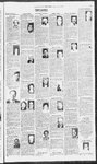
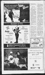
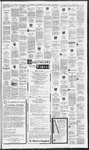
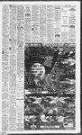
Show Fronts at their neon pasition. Tam ane bode Lo La Yesterday's National Extremes High. a Today's UV Index : . ™ we iS . Park City BaVS0/pc » Provo” Vern B4/66/pc +0 city © Moab , = t. George age veers Baeaipc_ rs Taysaips © Vernal Prove’ Prove Balitrog Builfrog St. George ga/6a/pc sd Neal aWe6/pe 86/S6/p Richfield Olpe SOOT a on Senses B/pc 9 8US2 OSE 6 Grande, SSB SEBS ansas City 86/85 2887 ates, 3668 De 3649 Margie Mav aeenreeccoe ea 8 Tahoe win Falls Air ‘ = “9 Sinks ; Lo Prep Hilo W Utah Updates on v os ae, \ > Today 3 Fairbanks = 0 4a ‘ ase $6 STs 3 86 Keo 59 ore " 8 Neshwile S78 Te New Orle oN8t 373 3 one 79068 0.*1 7968-56 = 0.04 96/76 s 86/85 pe 3 m 9 386 pes shes BRB ee BMRBES S278 GOR SNF) 8 288 5 BSI Tr SED pC 91/80 pC 3 5459 pe ess Columbus, OH 3748.9.00 8NS2 pe 78Sis Tr Concord oe Ser Bip ez = = aa: Weather(W): SAB. QORSOIST pe anes i Som fe Ss Wed . Park Cit expected precipitation ice - mS i ane ibe + ican oon Positions of Furies _ . gf. $5/70/pc 90/66/pc 86/58/pc \\,5, Richfield r S7ICOIPS gaieaipc * ” i aut Bullfrog ed : ba * ' x 200 Bune Cole, Spgs i Pes pe e 4 Tonight « Spr tom Regional Cities Yesterday 88/58 Richfield Epc Today “ Ee \y on Ran Sunrise/set Nove Uggan Vail T-Storms g sive? > jeaihy Tomorrow's Precipitation Nana ‘Today's Precipitation st 3 ecipitation, Te-trace Home Equity Loans by OG nin low as (POOR |