| OCR Text |
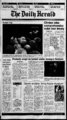
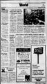
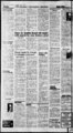
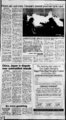
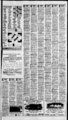
Show JThe Dally HraM Tuesday, September 24, 1996' Rsoofd! lows hit Partly cloudv The AccuWeather forecast for noon, Wednesday, Sept. 25. Bands separate high temperature zones for the day. northern Rockies ed for several towns in the area, and more heavy rain was forecast Thunderstorms rattled parts of in the state overnight, the National the Plains and Midwest with large Weather Service said. hail and intense rain on Monday, Before daybreak, hail while temperatures chilled to of an inch in diameter ratrecord lows along the northern tled parts of eastern Nebraska, " Rockies. including Boys Town, and wind The storms on the Plains develgusted to 62 mph near Fremont. In oped around a low pressure area Oklahoma, gusts reached 55 mph that was centered over south-centrat Bartlesville. Kansas and moving slowly More than an inch of rain fell on toward the east. Omaha, Neb., in about 30 minutes A line of severe thunderstorms and flooded some streets. That total of rolled across Kansas and Missouri, gave the city a kicking up wind gusts to 70 mph 1 .62 inches, and nearby Valley had and dropping hail as large as 1.76 1 .72 inches in 24 hours. also spread Thunderstorms inches wide. Radar indicated some areas near across Iowa, and showers and the Lake of the Ozarks in central thunderstorms were scattered from Missouri collected 3 to 4 inches of northeastern Texas to Illinois. was weather The stormy rain from 7 a.m. to early afternoon. Flash flood warnings were post expected to spread into parts of By The Associated Press three-quarte- rs al 90sXJ FRONTS: COLD WARM 24-ho- ur Marry Jorgensen, 8, Cherry Hill Elementary Of on Ont!oo!i By The Associated Press UTAH SALT LAKE, OGDEN AND PROVO: Tonight partly cloudy. Lows in low 40s. Wednesday partly cloudy and cooler with a slight chance of showers or thunderstorms. Breezy north winds. Highs in the mid-60- s. Chance of rain 20 percent on Wednesday. NORTHERN UTAH: Tonight partly cloudy. Slight chance of mountain showers or thunderstorms. Lows Wednesday partly cloudy and cooler with a slight chance of showers or thunderstorms. Chance of snow showers in the mountains above 8,000 feet. Highs in the upper 50s and 60s. SOUTHERN UTAH: Tonight fair. Lows upper 40s and 50s, 60s extreme south. Wednesday partly cloudy with a slight chance of showers or thunderstorms. Snow level lowering to 8,500 feet. Highs mid-70- s and 80s. DIXIE: Tonight mostly clear. Wednesday partly cloudy and cooler. A slight chance of afternoon showers or thunderstorms. Breezy afternoon north winds. IDAHO SOUTHERN IDAHO: Tonight mostly clear except partly cloudy to the mid-30- s. extreme east. Lows from the mid-20- s Wednesday mosin the mid-50- s Cooler. extreme east. Highs cloudy partly except sunny tly "through the 60s. " CENTRAL IDAHO: Tonight mostly clear except partly cloudy east. Lows from the upper teens to the lower 30s. Wednesday mostly sunny west. Partly cloudy east. Cooler. Highs 55 to 65. " NORTHERN IDAHO: Tonight partly cloudy in the evening. clear after midnight. Patchy fog north late. Lows 30 to 40. u Wednesday patchy morning fog north. Otherwise mostly sunny. Highs o35 to 65. "v TREASURE VALLEY: Tonight clear. Lows in the mid-30- s. ,,JSorthwest winds 5 to 10 mph shifting to the southeast around midnight. Wednesday sunny but cooler. Highs 65 to 70. Southwest 'MAGIC VALLEY: Tonight clear. Lows in the mid-30- s. lt winds 5 to 15 mph. Wednesday sunny but cooler. Highs in the mid-60WEST CENTRAL MOUNTAINS: Tonight mostly clear. Wednes- day sunny. NEVADA m Z NORTHERN AND CENTRAL NEVADA: Tonight mostly clear. 2 Low in the 30s to mid-40- s except mid- - to upper 20s northeast. Wednesday mostly sunny. Highs in the 70s to lower 80s. SOUTHERN NEVADA: Tonight mostly clear. Lows in the upper Z 250s to upper 60s. Wednesday mostly sunny. High in the 90s. ARIZONA STATEWIDE: Tonight partly cloudy east with a chance of evening Z showers or thunderstorms in the southeast. Fair elsewhere. Lows mid-11- !: deserts. Wednesday partly cloudy central 30s mountains to mid-70- s Z mountains and southeast sunny west. A little wanner. Highs near 70 Z mountains to near 102 western deserts. - SHOWERS LOW TSTORUS fSAIH FlUflHIfS Indiana, Kentucky and Tennessee during the night. Farther north, light to moderate showers were likely from the Plains across the upper SNOW ll Q & PT ClOUOY SUNNY (C ClOUOY Midwest into the northern Great Lakes. In the East, clouds covered much of New England anH ers lingered along the Maine coaSt. show-norther- n national Tcmpciatui os By The Associated Press Monday 35-4- 5. s. C 1996 AccuWeather. inc: EES HL HIGH STATIONARY Temperatures indicate previous day's high and overnight low to 8:32 p.m. EDT. Abilene.Tex. Aibany,N.Y. Albuquerque Anchorage Asheville Atlanta Atlantic City Austin Baltimore Baton Rouge Billings Birmingham Boise Boston Buffalo Burlington.Vt. Caribou.Maine Casper Charleston,S.C. Charleston,W.Va. Charlotte,N.C. Chattanooga Cheyenne Chicago Cincinnati Cleveland Colorado Springs Columbia.S.C. Columbus,Ga. Columbus,Ohio Dallas-F- t Worth Daytona Beach Denver Des Moines Detroit El Paso Eugene Fairbanks Flagstaff Fresno Grand Junction Grand Rapids Great Falls Green Bay 72 45 51 55 25 78 85 49 60 70 55 72 81 89 73 86 58 83 61 59 55 59 85 72 83 83 56 55 68 72 66 66 47 46 .13 .03 .02 38 .01 .01 .01 .25 57 47 ( ,54 '58' ' m 85 ,( 91 71 .02 56 70 58 66 68 .41 56 58 36 55 34 49 47 48 36 30 58 50 66 62 87 87 Pre Otlk Lo Hi 90 56 51' 72 '63 t 45 54 - 60 39 i .84 .07 53 44 70 89 cdy cdy clr rn cdy cdy cdy cdy rn cdy clr cdy clr cdy rn cdy cdy cdy clr rn cdy cdy cdy clr cdy rn cdy clr cdy cdy cdy clr cdy cdy rn cdy clr 25 39 61 78 53 69 58 63 44 26 42 . .02 cdy clr clr clr m clr clr 77 Greensboro.N.C. Harrisburg Hartford Spgfld Helena Honolulu Houston Huntsville Indianapolis Jackson.Miss. Jacksonville Juneau Kansas City Knoxville Las Vegas Lincoln Little Rock Los Angeles Louisville Lubbock Madison Medford Memphis Miami Beach Milwaukee Mpls-S- t 71 64 59 89 m 83 72 89 87 48 77 82 28 75 65 54 52 52 56 45 66 rn cdy clr clr cdy cdy cdy cdy clr rn clr cdy clr cdy cdy cdy cdy cdy clr clr .10 57 64 80 86 88 77 65 50 .01 71 51 .08 87 83 87 65 56 55 64 59 .01 71 90 81 79 92 Paul 51 67 74 85 cdy cdy clr cdy cdy cdy 62 70 78 77 73 clr .02 .14 51 47 .52 .01 41 clr 68 59 58 48 48 54 59 m m 73 68 42 43 75 59 63 86 91 cdy cdy 1.23 59 81 61 1.12 61 .06 Yakima Yuma M 47 53 68 70 57 72 60 56 30 73 65 SanJuan.P.R. St Ste Marie Seattle Sioux City Sioux Falls rn cdy clr clr cdy clr .03 .02 Spokane Springfield.Mo. Syracuse Tallahassee Tampa-S- t Ptrsbg Tulsa Tupelo Waco Washington.D.C. Wilmingum.Del. 67 54 78 42 44 53 48 30 73 San Diego San Francisco cdy rn clr clr cdy cdy clr clr cdy 89 61 65 72 66 88 86 84 87 89 73 69 99 cdy cdy cdy rn .40 clr USE THIS I 87 62 91U " COUPON FOR ALL DUALITY Sl!!J GLASS J r a?' rTH-- ,C,'i, TV tat Xffnnv Itrgt, 7.0 dryer drum ndisxt tkmna Quidt-St- Convtct Routt SrlfcUmmf md Conrnl mm AutomMtk Bake opnont witfi Attmu '"V'. M Ultra Dryer Ban Electric Range with fnwvrrnnN 30" dryt eu. ft- "t & JENNAR MIDIOOO Temp" uxuer hetig Top-Mou- Wf tpnon UcUnf lijmMt gUa shtlvn iuuA tyttem Dtfp 20yer womtnty on QmetUner" tuh frmtr thehm fnrur im TA-- sbeif Bdjkrl A Expressions Collection 20 cu. ft. w?T' Refrigerator Fdcwn mstdlUJ penmrtrr dot 30" Free --Standing Electric Range with Deluxe Coil Elements mm ftr cmm dm ftmil CnchrdlcuM ttr ltd wmttr anvmmct mttr MSduoynone Cnomr-dtf- PnaUmdnf tdjuuile ii deipfor huh-- Infini Ink tculi anml tftttnp INIM-AV- 4 affordable for everyone! The AT&T Go Phone Now cellular phone service can be airtime and peace of mind; includes 1 20 minutes of k provides comfort, security for kit 39.99! 1 9.99! Receive your starter only per month for only 30" Gas Range Ultra Washer off-pea- Ultm with Sealed Burners High pttfifMGMCt iimtfi widt upcitji.l cu.fi. ibbW of cellular phones Fnr Tfttd ttnitimnu UHULmiditHPmtm lUtxmkamtnk Hmfdutj mumiaitm rounded up to the next full minute. Credit card verification Airtime is billed in full minute increments, Phone must be activated within seven (7) days of and activation billing. required for purchase, Off-pea- k hours are service commitment required with fee for early termination. Durchase 1 details. for further store See and weekends holidays. Friday 6 p.m. to 8 a.m., out-w- Bimmcfikdm ipiukm wuh SvtFUmt" tfimn frtrnmn Etfhtcyk J ' ffJl Monday through 579-666- Mrtgt do ExpandaMt nll-t- Saturday 10 a.m.-- 9 p.m. (except Salt Lake Downtown Shop Ait stores Monday through Saturday 10 a.m.-- 7 p.m.). Closed Sunday. ZCMI and elsewhere in Utah and in the U.S., Lake, In Salt Order by phone: 0 drmum fldutheiva ZCN4I nt Refrigerators Dumion" rock finish with 5 year womtnty BnSUENIM-A- bright white mm drylets dry optwm anmll The Quietest Dishvsasher Made in America' fin-j- and see our complete lineup Come to our Electronics Departments and a full line of accessories. and Sony", NEC" from Motorola", II INSURANCE Deity Start option at at clr .dr CtMwtB Banker Weft RKy 484866 Ace 19.99 per month! ppllnUr Co Phone clr cdy Twice Hie Service u; ill L JPP5 c,dy : "Ctrl & Dottia" Thornhill I Via cdy sdy your J insurance J DEDUCTIBLE I Three temperature seleownj Authorized Hewier "clr clr coupon valuable 6 CI CfnVfe off Wf AW Wireless Services cdy rn 1 - (ForoaDDy, affiocdabile ceDDnaOaG' pltooinie clr cd , clr unmanranffM cdy 67 70 64 62 70 63 62 57 72 55 24 47 44 SERVING MOST ALL 01 CENTRAL UTAH WITH 2 l $ II 01 67 97 Philadelphia Phoenix Pittsburgh Pocatello Portland.Maine Portland.Ore. Providence Rapid City Reno Richmond Roanoke Rochester Rockford Sacramento St Louis St Thomas Salem.Ore. Salt Lake City San Antonio cdy .12 .75 72 56 59 64 55 66 45 37 64 94 Montgomery Nashville New Orleans New York City Newark Norfolk, Va. Oklahoma City Omaha Orlando Peoria 53 55 W) c APPLIANCE v m &&0 0 v |