| OCR Text |
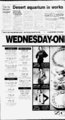
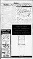
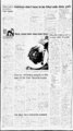
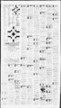
Show Tuesday, October 31. 1995 Current Weather Forecast By The Associated Press UTH STATEWIDE: Tonight mostly cloudy with a chance of showers. Wednesday much colder. Mostly cloudy with a chance of Ijnws powers. Local breezy nonh winds. Highs Extended forecast. Thursday through Saturday remaining cool and unsettled with a chance ,i vailey rain and mountain snow. Lows in the s to near 40. Hishs ffom the upper 40s to upper 50s. SALT LAKE, OGDEN AND PROVO: Tonisht mostly cloudy with -- I 33-4- 5. 45-5- 5. mid-20- -- ; chance ot showers. Lows 40-4- 5 Wednesday much colder. Mostly cloudy with a chance of showers. Local breezy north winds. Hishs near 50. Chance of precipitation at Salt Lake Citv 30 percent toniaht and 40 percent Wednesday. ' 'SOUTHERN UTAH: Tonight mostlv cloudy with a chance of showery Lows J5-5Wednesday cooler. Mostlv cloudy with a chance of showers and thunderstorms. Highs upper 50s to near 70. Extended forecast. Thursday through Saturday remaining cool and unsettled with a chance of valley rain and mountain snow. Lows in the 30s and 40s. Hiahs from the upper 40s to near 60. "DIXIE: Tonight mostly cloudy with a slight chance of showers. Wednesday mostly cloudy with a chance of showers and thunderstorms. Coaler. a; 0. IDAHO 'NORTHERN IDAHO: Tonight areas of low clouds and valley fog sjnufh. Otherwise partly cloudy and cold. A chance of snow near the Mon"-tn-a border. Locally breezy. Highs near 40. Lows in the teens. Wednesday .partly cloudy and colder. Highs 35 to 45. Extended forecast, Thursday .through Saturday mostly clear and cold with areas of fog and low clouds in the river valleys. Lows 15 to 25. Highs in the 30s to the lower -- M)s. 'CENTRAL IDAHO: Tonight night mostlv cloudy with scattered stiow showers mainly east. Locally breezy east. Continued cold. Highs in the 30s and 40s. Lows 10 to 20. Wednesday partly cloudy w ith a "slight Jhance of snow east. Fair west. Colder Highs in the 30s east and the rriid-i- s west. Extended forecast. Thursday to the mid-40- s through Saturday rfcostly clear and cold with areas of fog and low clouds in the river vaf-lfcLows zero to 15 above zero. Highs 25 to 35. SOUTHERN IDAHO: Tonight fair west. Mostly cloudy east with a ; cjiance of snow showers. Locally breezy east. Colder. Lows in the teens ;(jid 20s. Wednesday partly cloudy east with a slight chance of snow east and sjiowers. Fair west. Breezy east. Colder. Highs in the mid-30- s rjeat 40 west. Extended forecast. Thursday through Saturday mostly clear id cold with areas of fog and low clouds in the river valleys. Lows in tjie teens east to lower 20s in the west. Highs 25 to 35 in the east to near 40 in the west. NEVADA ! 'NORTHERN AND CENTRAL NEVADA: Tonight mostly cloudy I ltft a chance of showers mainly along the mountains. Snow level 6,500-lu)- 0 feet. Lows in the 20s nonh to lower 40s west and central. Wednes-j- a ' partly cloudy west and mostly cloudy east with a chance of showers tih airily over the mountains. Cooler with highs in the 50s north to lower (j()s west and central. ! 'SOUTHERN NEVADA: Tonight mostly cloudy. Lows in the 50s. . Jjiesday partly cloudv. Highs in the 70s to lower 80s. s. -- S By The Associated Press Snow fell in Bismarck. S.D.. and Casper. Wyo.. this morning and a band of rain swept across the Great Lakes region. It was raining in Chicago. Detroit. Cleveland and Pittsburgh, while the South and central Plains were enveloped in clouds and fog. Temperatures before dawn ranged from a high of 8 degrees at Key West. Fla.. to a low of 7 at Cut Bank. Mont., where the wind chill yesterday dropped the temperature to minus 12. Winds battered the Northwest, and snow was likely from the northern half of the Rockies and the upper Plains to the upper Great Lakes region. Clouds were expected to spread across California, bringing the threat of showers along the coast and in the mountains. Scattered showers and some were headed thunderstorms towards southeast Arizona to Texas and Oklahoma and from there to Florida. It should rain over the rest of the central and eastern part of the country, with some snow mixed in from upper New England to the lower Great Lakes. Temperatures should be in the 30s in the upper Plains. 40s in New England and Great Lakes region and 50s in the Northeast and upper Midwest. Most of the South and California will be in the 60s and 70s. w ith readings in the 80s in the desert Southwest and southern Florida. Monday's hot spot was 94 degrees in Lake Havasu City, Ariz. The cold spot was 2 degrees in Cut Bank, Mont. 0 1 The Accu Weather forecast for noon, Wednesday, Nov. 1 30s Bands separate high temperature zones for the day. l 50s 1 I i v-- . V 1 Vrrzi 10s I I n r "Arv"30svAC x J x x x x f x ! m ,! N i N mk y sZr VasJ FRONTS: WARM COLD STATIONARY 1995 AccuVVeather, Inc. Pressure H L HIGH LOW SHOWERS RAIN EZ3 23 FLURRIES SNOW m ICE 0 gdL SUNNY PT. CLOUDY CLOUDY Via Associated Press Other reports at 5 a.m. EST (atmospheric conditions not available for many cities): EAST: Albany. N.Y.. 31: Atlanta 51 cloudy; Boston 42 fair; Buffalo 40 drizzly; Charleston, S C.. 59 fair; Chattanooga 'STATEWIDE: Tonight increasing showers from the west. Lows 5 fog- gy: Cincinnati 52: Cleveland 45 rain: Detroit 40 rain: Jacksonville 64 cloudy: Key West 81 rain: Knoxville 50 cloudy: Macon 53 partly cloudy; Miami 79 partly mm OKI UG00 ARIZONA ; 344-800- A7 Rain, snow fall on high Plains Aiea Outlooh r" - Page THE DAILY HERALD. Provo. Utah, cloudy: New York 50 cloudy: Philadelphia 51 cloudy; Pittsburgh 45 rain: Portland. Maine. 28 fair: Richmond 51 partly cloudy ; Tampa 67 partly cloudy: Washington 54 cloudv. AQ, to around 60 on the desert. Wednesday scattered ijpper 30s mountains lowers. Cooler with highs from the lower 50s mountains to the upper jjOs desert. a GO' y GflG uGOOMGOu fP4 0 t " I I --HEN S3m mm " v,fMB, II MI"":" m SoC I I New Business Checking Account Cut Thi th( Ail' On a the ji 'iuih tiif r)' w ImmIIcw Save Now On A t Hassle-trt'- e Interstate Bank, .kuiuihs. PC. payroll options. At we make with something as simple as LOW LOW FINANCING AVAILABLE AS LOW AS scissors. Hrini; the above coupon $35 PerMo. or, it you O.A.C. husnu'ss a pair ot in today like, pick up another simple instrument. Just call your nearest bunch. CALL US TODAY LEWIS & GUYMON ' products and services. And occasionally. ,ulpm.nt 225-106- 1 1 m'iU:'1'. banking easy with the most advaiuet Lennox Pulse Furnace Jmlimi .hf-k'- r j. ta: mn ' it ni.':r-r- i Ijrn! Ins .1' 'Hints inli moncv market banking. md tlfleltney of ok) Mflit-- 1 . Tiered First iv r t'K .ill pirr-- Furnace The natural gas Lennox Pulse new use wiuiu slashes vour energy on Payback energy efficient designtakes few a just Cli!?MSns. It's 97 efficient. 'l tht rnnr"!i, jirr "inn.! Nurr i. i Jijrfi! A(tr-- Costs inergy cfnd. oo Months tree of Monthly I Maintenance Fees I Check out a new Natural Gas Lennox Pulse Mrt u()Q r""i jix I Ex fBQP0K9Q r&Aii M ssociATmN SMBuQSu O you --- jj -- - Member FOIC |