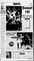
| OCR Text |
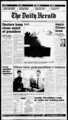
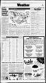
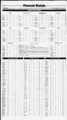
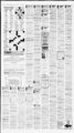
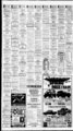
Show The Daily Herald Monday, March HI, 1SB7 orni The AccuWeather forecast tor noon, Tuesday, March 1 B. By The Associate!! ?res6 Bands separate high temperature .zones 1 orlhe day. lITtH CXIUMlf: Tonight xiear. Lows mid to upper 3(is. Tuesdii) sunnv and warmer. Wigh, mid 60s. iJEWlllE: Tonight .clearing and xuuler. Low 25-4Tuesday sunnv and warmer. iHighs '60s. toman 0. NORTHER ID&ilO: Tonight xloudy. Rain developing to 4 inches new snow above 4.0U0-- .500 teet Low,1, tonijiht nam uiiiuii viui wmiw it in siiwei os. J uesuay 5.000 feet. Mostly xloudy south with a xhance.ol rain showers. Warmer with highs in the 50s north to CENTRAL ill) .4110: Tonight mostly xloudy.Chunce ol rain or snow north and west portions after midnight. Lows in the 20s to lower 30s. Tuesdav partly cloudy and warmer. High in the 50s to lower 60s. SOl'THER' IDi'HO: Tonight mostly xloudy west with a slight chance of rain showers after midnight. Partly Xloud rust. Lows in thr mid-20- s to lower 30s east, mid- - 30s to lower 40s west. Tuesday mostly sunny and much warmer. IHighs in the 60sxcept locally in the 50s in thr southeast highlands By The Associated Press "Snow spread into the Great arly today, while rain drenched coastal Texas and the pacific "Northwest. Conditions were calm over most of the rest of the nation. High water was .expected to xontinue on the lower Ohio River for much of the week. The river remains more than 10 feet above flood stage at the Kentucky towns of Paducah and Smithland. Over the weekend, the river xrest flowed into the Mississippi River, which is wider than the Ohio and ran accommodate more water. In 'Michigan, xrews were working through the night trying to restore powerlo tens of thousands of homes and businesses after severe ice storm. A storm system in the Pacific "Northwest was sxpected to keep moving east into the Rocky 'Mountains, bringing more rain and up to 4 inches ofsnow today. The Southwest was .expected to remain dry throughout the ilay, as was the eastern third of the nation .except for possible scattered snow in "New 'York and Pennsylvania. Gusty winds xould blow across the Plains and western Great Lakes states.Scattered showers anda few severe thunderstorms also may Lakes and northern Rockies ttWRAl Monday Temperatures indicate previous day's high and overnight low to 740 a.m. EST. Hi ho Pre Otlk AbiieneTex. Akron.Ohio A!bany:N.Y. Albuquerque Alleniown.Pii. Anutrillo Anchorage Asheville Atlanta Atlantic Citv" Austin Baltimore Baton Rouge Billings Birmingham Bismarck Boise Boston Casper Charleston.S.C. Charieston.VV.Va. Charkme.N.C. Chattanooga Cheyenne .Chicago Cincinnati Cleveland Colorado Springs Columbia.S.C. Columbus.Ga. ,Coiumbus.Ohio Concord.N.H. C!ipusChrisli Dalkis-F- t Worth Dayton Uavtona Beach Denver Des Moines Detroit Duluth El Paso Elkim Erie Eucene "50 .cdv 12 26 26 .11 74 46 .cdv r"52 cdv .cdy cdy .cir "33 17 75 27 45 50 60 25 '39 .cdv .cdy 38 H .cdv 32 41 "50 LV 61 58 61 .cdv 22 3 xdv .clr 49 .01 m 31 to 77 cdy 46 18 sn 62 45 22 .10 .cdy "39 36 cdv "31 61 60 41 "37 '35 '35 39 '30 .cdy .cdy clr cdy cdy cdy cdv 27 33 54 54 31 60 31 28 .cdy "72 44 cdy '57 64 31 .cdy niid-6()M- COLD H L HIGH Via LOW Evansville Fairbanks Eargo Tlagsiaff Flint Fort Smith FonVvavne Fresno Goodland Grand Junction Grand Rapids Helena Honolulu Houston Huntsville Indianapolis .Jackson.Mtss. Jacksonville Juneau Kansas Gty Knoxville JLake Charles SUNNY RT.XWUVY CLOUDY xdy New York Cits 69 6(1 :cdy 70 40 "52 36 "31 23 29 22 81 62 35 t9 'Newark "NorfolkAi. North Plane Oklahoma City Omaha Orlando Paducah xd xdv .14 50 cdv Providence "Pueblo 1 73 76 cdv .clr' .cdy 71 49 KapulCrty eno 29 39 27 .cdv .cdy 32 ..cdy 85 .36 ;54 72 34 .cdy " .Richmond 36 .cdy 33 62 66 47 47 29 49 25 45 sn 30 29 .cdy m cdv .02 cdy .cdv 34 27 78 52 22 m 26 40 "31 62 63 37 30 33 33 63 34 58 49 ' .cdv .cd'v ' .ah 31 70 28 .clr 31 63 39 .cd cdv 47 47 28 30 44 ,cd 82 m .cd 33 64 39 64 84 70 22 62 33 35 29 rn 25 .cdv cd .09 clr 70 m ,cd xdy .14 .cdy dr 55 34 :cdy 47 34 30 42 32 32 cdy cdy 40 73 39 .cdy cdy 47 4. rn rn .01 P cdy cd 38 30 45 .cdy .cdy .cdy x& clr 46 81 9 35 37 31 33 32 6 63 49 40 49 34 35 27 24 .cdv 33 dr W'iiminston.Del. 31 .cdy .cdy '.Yuma .cdy cdv "NationalTemperature Extremes High Sundav Cat Coolidge and Gilu Bend. Anz. .Low Mondav 7,at Berlin and Whiteticld. 64 34 36 44 66 31 0 "78 Peona 48 42 Philadelphia 37 46 35 37 42 .cd'v .cd'v cd'v .02 cdy to 37 .01 .cdv 25 .cdv cdv ' 33 Toledo Topeka Tucson WashingtonD.C. W.PalmBeach Wichita Wichita Falls Wilkes-Barr- cdy 80 g 31 84 44 32 80 70 55 54 46 30 28 e K 24 '84 59 .Northridge Elementary 1 BSD North 5D East Steve .Heinz, Council Cherry Hill Elementary 25D East 1B50 South Media Center Gym Chris Yandow, Council Tim Christensen, Council Hillcrest Elementary Stephen Sandstrom, Council m 43 "Tanrpa-SiPtrsb- ! .cdy 27 25 70 clr 41 xlr -- . Members uf The City Council will e tiDsling opervagenila Town Meetings IhrDughoLrt Drem on Tuesday, March IE, from 7 p.m. until B30 p.m. Drop y for a "few minLrtes or stay lor Ihe entire meeting. Donl miss Uiis opporiimrly to share your comments, concerns, and ideas with your elected officials. Ydlj are welcome to attend any of The meetings listed below. For more information, oal! 229-707We hope to see you at the Town Meetings Dave PaSf reyman, Council Stella Welsh, Mayor Cascade Elementary Bonneville Elementary 16D North BD0 East 1245 North BOD West Annex Auditorium Media Center m m W 37 .cdv xlf 34 -- STATEWIDE: Today light snow .decreasing by midday westeiii mountains. Partly to mostly xloudy rest of state with scattered mainly mountain snow showers. Windy areas with highs in the mid-40- s to near far west and mountains. Tonight a lew mountain snow 60, 30sto mid-40- s showers early otherwise becoming xlear to partly cloudy. Areas of brisk winds. Lows in the 20s to low 30s mostiv teens mountains and far west. WASHINGTON WESTERN 'WASHINGTON: .High wind watch xoast tonight through Tuesday. Today showers this morning Steady Tain developing this afternoon Windy xoast H ighs 50 to 55 TI on ight and Tue sday ,pivi-bl- e strong south winds 35 to 45 mph with gusts to 55 mph .on thexuast fate tonight through Tuesdav. OREM RESIDENTS COME TO A TOWN MEETING! cd'v 42 32 49 Spnnslield.Mo. Syracuse Tallahassee 47 47 35 fair; Rapid City35fair;vSan Antonio 57 misty;:5t.Louis46xloudy. m 60 49 cdv .f5 .02 .cdy .clr .cdv .21 38 62 0 Sat, Juan.P.R. cdv .cdv 33 Santa Fe St Ste Marie Savannah 'Seattle Shrevepon Sioux City Sioux Falls SouthBend Spokane 42 S 47 39 Sacramento St Louis St Thomas Saiem.Ore. SaitXake City SanAngelo San Antonio ""SimDiego San Francisco San Jose m 35 45 -- Raleieh-TJurha- 40 62 Thoemx Ymsbutgh Tocatello Tonland.Matne "Portland.. rn .cdy cdv .clr .cdv 32 6" 26 30 45 37 31 36 47 88 34 66 Mobile Montgomery Nashville New Orleans Birmingham 40 fair; 55 .06 Mpls-StPa- - '.Central: 28 25 '34 Milwaukee partiyxloudy. 7 27 lis : 38 31? Bismarck 21 xloudy; Chicago 37 ; -- 48 a .C. 37 :fair; Chat- Charleston, 32 54 27 30 33 61 Midland-Odess- rn 8 35 50 36 j93 37 t6 JLrttleock Los Angeles 66 21 43 .Lincoln 2 46 ICE tanooga 32 fair; Cincinnati 35 windy; Denver 39 xloudy; l)es .cloudy; Cleveland .33 xloudy; Moines 37 fair: .Fort Worth 48 Detroit 33 xloudy Hatteras 35 fair; .misty; Galveston 64 rain; Jacksonville 48 fair: Key West 73 37 xloudy: Kansas City 46 windy; iKnoxville 32 rfair: 'Macon windy; Little Rock 48 xloudy; 33 lair; Miami 69 fair: 'New 'York Louisville 3 xloudy: Memphis 53 24 fair: Philadelphia 26 fair; Pitts- xloudy; 'MinneapolisSt. Paul 35 burgh 26 xloudy; Portland. Maine xloudy; 'Nashville 39 xloudy: !New 15 fair; Richmond 28 :fair; Tampa Orleans55 farrA'orth Platte 32 fair; 57 misty; Washington D.C. 33 i Oklahoma City 48 misty Omaha 37 .04 .cdv .cdv .cdy .cdv -- .cdv .cir .cdv .cdv 69 53 SNOW FLURRIES - 26 26 RAIN develop later today from Texas to Arkansas, a region already "facing some flooding. The hot spot in the lower48 states Sunday was 89 degrees in Goodyear, Ariz., while the .coldest spot was in By, 'Minn., at 23 below zero. Other reports at 4 ji.m. 3EST (atmospheric xonditions not available for manv .cities): East: Albany, N:Y. 10 fair; Atlanta 42 lair; Boston 23 fair; Buffalo 24 xloudy Caribou J fair: 38 33 cdy .cdv .cdv cdy .clr cdy cdv SHOWERS Associated Press Louisville Lubbock Macon Madison "Medlord Memphis Miami Beach cdy 1S97 AccuWeatfier. Inc. Pressure .Las Vegas .cdv STATIONARY .WARM .cdy clr () s. 36 ;edy sn 1.16 .01 D "NORTHERN M?V:4I)4: Tonight partly xloudv northwest. Pair skies central. Lows in the upper 20s to mid-30Tuesday mid-70- s. o mostly sunnv and warmer. Highs in the SOUTHERN Tonighl mostly xlear. Lows in the mid-4to mid-50Tuesdav sunny. Highs in the 80s to near 90. ARIZONA STATE WIDE: Tonight decreasing xlouds southeast mostly clear elsewhere. Lows in the 20s mountains to upper 50s desert. Tuesday mostly sunny. Warmer highs near 60 mountains to low er 90s w armest desert area-,- . XJJjORAJK') STATEWIDE: Ton ight part ! v xloudy. Lows 10 to 25 mountains! to 40 west.20 to 35 east. Tuesday mostly sunny. Highs 40 to 50 mountains 55 to 70 west. 60 to 70 east. FRONTS: -- By The Associated Press Mountain View High 45 West Center Cafeteria , :cd cdy cdy cdy 51 East 14DD South Small Gym .cdy cdy i "2 Kti. .sr ' rt.' Waters stop rising; disaster far from over The PADUCAH. Ky. (AP) Ohio Rivers crest flowed into the Mississippi River over the weekend, raising hopes of it respite for weary disaster workers and flooding victims. "Our people are real tired." said Kent King, stale emergency services coordinator tor the Paducah .area. "We've been going 12 to !6hoursa day for two weeks straight."" King doesn't expect much rest, though, as workers shift from response to recovery and the high water recedes by only inches a day. "It's not gotten any worse, let's put it that way," he said. The National Weather Service said the high water would xontinue on the lower Ohio River for much of the week. The river remains more than 10 feet above flood stage at Paducah. protected by a flood wall. and at Smitliland. protected by a south because the Mississippi River is wider than the Ohio and .can hastily assembled levee of sandbags. About 80 percent of the people accommodate more water. The river is expected to .crest Tuesday tn Cape in Old Shawneetown. 111., left durGirardeau. 'Mo., at 35 feet, comof the The worst the flooding. ing situation improved enough Sunday pared with the flood stage of 32 feet. in 'Natchez. Miss., business for Mayor Freeman Oldham to end a voluntary' evacuation and .curfew. owners hi a small shopping area Even with an expected smatteralong theriverplanned to celebrate levels river even if water blocks off their rain of Tuesday, ing should continue falling from highs entrance street. A troliey system would serve as their backup. not seen since 19.T7. said meteorolthe "We're going to give people a of David Humphrey ogist National Weather Service. party and a great place to watch the Severe Hooding should not be a river rise." said Linda Guice. owner problem for Missouri and points ofThe Natchez landing restaurant. V N1 Trui2le5TTiDDThie5 I I LUDi'uTOKMJSTGAGE raePragualthcubon Lonmt Ratal Cuaraniaad Atler hour appoimnwrts 190 W BOOK SiKb 201 I J t. j Iwww cDTirbinntiDn of juice and TrsshTnjrti)bnded with be NfjtritiDn Made Delicbiis! i flu Conveniently located At P A 2 L7il'- - SOUND QUALITy WES.3wr-ORE- I American fork 537 f. State id. Homing toon M I 1 1 p-- nre nn invigorating TDrnoirfivvsringperfectbn. 224-944- 4 I again ilate in the tu :u, Wiiraclear fieatont Grove i T f I I 4EI.5toteld. to Orem ond lehi. I Dne coupon per. customer per vmt Dfe isixtftjoarJ m combmaiioni'itn:ony olner otter Good only ot me American Fork ond Pieaiont &rue SUB WA7 testauronts ixpires "3 '3 ! 97. Limit- mm mm |