| OCR Text |
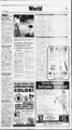
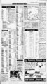
Show A, I? The Daily Herald Tuesday, September 20, 1994 Partly cloudy skies in tonight's forecast By The Associated Press UTAH Salt Lake, Ogden and Provo: Tonight partly cloudy. A few evening thunderstorms, Lows in the 50s. Wednesday partly cloudy. Chance of Highs low to rslin 20 percent tonight. Ogden temperatures: 82 54 82. J Northern Utah: Tonight partly coudy. A chance of evening show-ef- s s and thunderstorms. Lows to Wednesday partly cloudy. A slight chance of afternoon mountain thunderstorms. Extended forecast, Highs Thursday fair. Lows 40s to low 50s. Highs Friday and Saturday partly cloudy with a few ifliMkMsaiair, The Accu-Weath- ited Press forecast for noon, Wednesday, Sept. er Tuesday 21 reviews EDT. Hi..U.Pre.Otlk Bands serjarate hiah temoeraturo - zones for the dav. , r US day's high mid-80- s. 65 cdy Uiineton 78 50 Lincoln Uttle Rock Los Angeles Louisville Lubbock Macon Madison Medford 84 59 Albuquerque 82 58 clr cdy Ashevilie 73 47 mis cdy Atlanta 78 60 cdy Atlantic City Austin 76 44 clr 88 65 cdv Baltimore 79 clr Baton Rouge Billings 84 52 64 cdy 79 50 rn Birmingham Bismarck 81 60 cdy 85 56 Boise Boston 86 51 71 53 Bridgeport 74 49 Brownsville Buffalo 92 68 cdy 70 50 clr Burlington.VL Caribou 66 45 cdy 53 34 ' Southern Utah: Tonight and Wednesday partly cloudy. Scattered showers and thunderstorms. Casper 80 46 clr rn Charleston,S.C. Char!estcn,W.Va. Charlotte,N.C. 77 68 cdy 76 49 clr 78 55 cdy Lows Chattanooga 80 59 Cheyenne Chicago Cincinnati Cleveland Colorado Spgs 72 45 70-8- 0. 60s' thunderstorms. Lows in the 40s to mid-50Highs 75-8s. 5. to mid-50- s. Highs 75-9Extended forecast, Thursday partly cloudy with a few thunderstorms. Lows 40s to mid-50- s. Highs 75-9Friday and Saturday partly cloudy with a chance of showers and thunderstorms. Lows in the 40s to mid-50- s. Highs 75-9Dixie: Tonight and Wednesday mostly cloudy. Scattered showers and thunderstorms, Mainly afternoon and evening hours. Chance of rain at Cedar City 40 percent tonight and 30 percent Wednesday. s mid-40- 0. 0. FRONTS: 0. IDAHO Northern Idaho: Tonight and Wednesday fair, but locally breezy on Wednesday. Lows in the 40s and lower 50s. Cooler Wednesday with highs in the upper 60s and the 70s. Extended forecast, Thursday through Saturday fair. Lows 45 to 55. Highs in the upper 70s to upper 80s except near 90 lowest southern valleys. Central Idaho: Tonight and Wednesday fair, except partly Cloudy with isolated showers extreme east. Lows in the 30s and lower 40s. Cooler and locally breezy Wednesday with highs in the upper 60s and 70s. Extended forecast, Thursday through Saturday sunny and warm. West central mountains: To- night and Wednesday fair. A little cooler on Wednesday. Southern Idaho: Tonight and Wednesday fair, Except partly cloudy with isolated showers ex- mountains on treme northeast Wednesday. Lows 35 to 45 east and the 40s west. Cooler Wednesday with highs 75 to 85. Extended forecast, Thursday through Saturday sunny and warm. Lows 45 to 55. Highs in the 80s to lower 90s. NEVADA J t Northern and central Nevada: Xonight partly cloudy with a slight cfiance of thunderstorms. Lows in trie 40s and lower 50s. Wednesday slight chance of thunderstorms. Sighs in the upper 70s east to "Southern Nevada: Tonight WARM COLD Pressure H L HIGH LOW Via Associated STATIONARY 1994Accu-Weathe- 000 SHOWERS EZ3 FLURRIES RAIN 0SV SNOW ICE SUNNY Inc r, PT. CLOUDY CLOUDY Press partly cloudy with a slight chance of thunderstorms. Lows in the 60s to lower 70s. Wednesday a slight chance of thunderstorms. Highs in the upper 80 to near 100. ARIZONA Statewide: Tonight a few evening showers far north, otherwise variable clouds. Lows from the lower 40s in the mountains to the upper 70s on the southwest deserts. Wednesday a few mainly afternoon showers and thunderstorms over the far north and east, otherwise variable clouds. Highs from the upper 60s in the mountains to near 100 on the lower deserts. COLORADO Statewide: Tonight scattered evening showers and thunderstorms then decreasing clouds. Lows 30s in the mountains with 40 to 55 elsewhere. Wednesday partly sunny with widely scattered afternoon showers and thunderstorms mostly likely over the mountains. Highs in the upper 60s and 70s, except 55 to 65 in the high country. WYOMING Statewide: Tonight increasing clouds north with scattered showers late snow showers higher mountains. Partly cloudy south with widely scattered evening thunderstorms. Lows in the 40s, 30s mountains. Wednesday mostly cloudy windy and cooler north and east with showers likely. Snow showers northern mountains. Partly sunny rest of state with scattered showers. Highs 55 to 70, 40s to mid-50- s mountains. WASHINGTON Western Washington: Tonight fair. Lows in the upper 40s to mid-50- s. Wednesday sunny and warmer after patchy morning fog. Highs in the upper 70s to upper 80s. Eastern Washington: Tonight and 50s. Wednesday sunny. A little cooler mainly northeast. Highs from upper 70s northeast to near 90 exfair. Lows mid-40- s treme south. MONTANA Montana east of the divide: Tonight mostly cloudy and cool with scattered showers. Lows 35 to 45. Wednesday scattered showers south. A few morning showers north, becoming mostly sunny north during the afternoon. Cool, with highs in the 50s and lower 60s. Montana west of the divide: Tonight partly cloudy with a few showers over the mountains. East winds diminishing north but continuing south. Lows 35 to 45. Wednesday mostly sunny and a lit- -. tie cooler. Highs 65 to 75. Showers were reported in derstorms were falling along the Gulf Coast and in Florida, but most other places had clear skies this morning. today. And widely scattered showers were expected over parts of the Plains and the Rocky Mountains, where gusty thunderstorms hit Monday. Light showers and highs in Hawaii and along part of Alaska's coast, and scattered thun- Heavy rains and winds from a powerful storm in the Bering the 60s were expected in north- Sea were hitting Alaska's coast, bringing warm air to Oregon and Washington and pushing a Canadian cold front down into the northern Plains. amounts of snow fell Monday. south-centr- ern Maine, where 47 Pueblo 87 50 Raleigh-Durha- 77 51 cdy Newark Norfolk.Va. North Platte Oklahoma City Columbus.Ga. Columbus.Ohio Concord,N.H. Corpus Christi Dallas-F- t Worth Dayton 81 60 Omaha Orlando Paducah Peoria Philadelphia Phoenix Pittsburgh Pocatello Portland,Maine Pcrtland.Ore. Providence cdy cdy cdy cdy clr cdy cdy cdy 66 77 54 80 55 78 56 83 45 82 56 86 59 89 70 80 47 86 57 78 54 100 79 74 47 86 41 67 40 .02 .59 86 57 m 78 52 cdv cdv clr cdy Reno Richmond Roanoke Rochester.N.Y. Rockford 54 64 cdy 43 55 clr cir clr 82 53 59 31 84 76 77 84 56 83 51 cdy cdy 94 65 clr Goodland 79 50 Grand Junction Grand Rapids Great Falls Green Bay Greensboro.N.C. Harrisburg Hartford Spgfld Helena 81 58 80 48 78 47 80 55 clr rn 75 50 cdy 77 50 72 45 82 44 Honolulu Houston 95 80 clr clr clr clr 89 60 Huntsville,Ala. 81 58 70 79 53 Des Moines 83 57 Detroit 82 53 Duluth El Paso 80 57 92 Eikins Erie Eugene Evansville Fairbanks Fargo Flagstaff Flint Fort Smith Fort Wayne Fresno 71 70 52 84 I 1973-8- 6 1984-8- 8 1 982-9- 1 1980-8- 6 rn .42 cdy cdy 1989-9- 3 trace 1986-9- 3 48 48 83 53 Sacramento 93 57 St Louis St Thomas.V.I. 84 61 90 76 84 54 cdy Salem.Ore. Salt Lake City 87 62 San Aneelo San Antonio 90 58 54 cdy rn 92 62 47 cdy 66 clr San Diego San Francisco San Jose San Juan.P.R. Santa Fe 75 47 60 59 81 m 88 75 1.30 cdy 82 55 St Ste Marie 72 47 Savannah Seattle Shreveport 82 64 76 56 85 59 Sioux City Sioux Falls South Bend 85 61 88 63 cdv cdy cdv clr clr cdv rn cdy .23 cdy cdy cdy cdy cdy 58 86 56 clr 85 57 83 57 clr cdv Svracuse Tallahassee 64 48 clr 83 71 cdy -- IV TRUCK SPECIALS CHEVY FULL SIZE TRUCK OR BLAZER, SUBURAN ihs;an TOYOTA TRUCK OR FORD RANGER TRUCK OR BRONCO II uns, TOYOTA TRUCK OR ia.c TRUCK OR PATHFINDER y vit valuable coupon JsWEBILLOUT tZ7 f- - USE THIS COUPON MOST INSURANCE C l M u OFF YOUR INSURANCE 'Restrictions apply ALL QUALITY CLASS a- -, ihsa m 89 99 M29 s129 5 149 5 169 s189 . 5 FOR UP TO COMPANIES, No 5 5 $109 sta FORD FULL SIZE TRUCK OR BRONCO NISSAN HARDBODY .05 cdv clr cdv cdv cdv cdv cdv clr 80 ml & cdy .28 Spokane Springfield.IU. Springfield,Mo. 1988- - 92 FULL SIZE CHEVY TRUCK OR BLAZER, SUBURBAN C cdv clr cdv clr 77 71 1987- - 93 FORD FULL SIZE TRUCK OR BRONCO Clear skies and highs in the 70s and 80s were expected almost everywhere else. 55 86 83 82 CAR Highs in the 90s were expected from California's central valley through southern Texas, rising to the 100s in the extreme Southwest. 79 Rapid City Daytona Beach Denver al More rain was expected in Hawaii, where more than ten inches fell in some places on Monday. 59 70 61 52 I Showers and thunderstorms also were lingering in Florida, southern Alabama and Georgia Associated Press 83 66 85 80 Rains dampen Hawaii, Alaska By The m 61 86 ColumbiaC. 52 73 91 Montgomery Nashville New Orleans New York City 48 61 61 m cdy clr clr clr cdy clr cdy cdy cdy clr cdy cdy rn clr cdy 89 Mobile 74 80 54 82 clr clr 87 56 96 cdy 51 68 53 82 63 73 90 63 61 cdy cdy 50 54 90 79 58 35 80 81 81 50 79 64 Milwaukee 79 .02 58 83 23 cdy clr rn cdy rn cdy cdy cdv cdy cdy clr clr cdv cdy cdy cdy rn cdy cdy clr cdy clr clr clr clr clr cdv a Midland-Odess- clr rn .01 81 MplsStPaul 85 68 Memphis Miami Beach rn clr .01 .06 45 57 5. 42 58 93 42 46 75-8- 55 84 79 51 67 45 mid-50- s. .08 Lansing Las Vegas 74 Albany .N.Y. 87 mid-40- 72 55 cdy clr clr 57 90s 82 62 64 75 54 63 79 87 Ainarillo Anchorage 12 II 87 Abilene.Texas Akron Canton Allentown Indianapolis Jackson,Miss. Jacksonville Juneau Kansas City Knoiville Lake Charles 9)ffl fClUJ deductible "Call for details INSURANCE COMPANY APPROVED j 5 5 5 I 3 PUBLIC ANNOUNCEMENT m 83 Di IPS A TUESDAY MORNING 03IR3d SELL-OF- F Entire Stock Picture Frames 40OFF take an additional M ' I LOW CLOSEOUT PRICE Entire Stock Comforters & Matching Accessories ncludcs comforter sets and bedspreads, drapes, decorative pillows, dust ruffles and shams (excludes down comforters, sheet sets and duvets) 30OFF TAKE AN ADDITIONAL LOW CLOSEOUT PRICE Gifts Orta flm Srlrcliun DiKount taken U--ftH !, HI W Cata, l1 1 qiunMin an J item. vain tmkd Rtprtcr, fx See I how extraordinary the new Mirage hearing aid really is. Visit the authorized Miracle-Ea- r representative can tell if the Mirage is representative listed below. Only your certified Miracle-Ea- r first-han- d nghtforyou QREM 735 E to120Q University s 224-944- 4 Mall Next Individual restore natural won't aids may vary depending on proper fit, severity experiences hearing. Hearing of hearing loss, accuracy of evaluation and ability to adapt to amplification. Miracle-E- SIH rftcaNr to pnrvima purchm. I Introducing Mirage, the remarkable new hearing aid that's practically invisible. It's so compact, it fits completely into the ear canal. Because of its compact size, Mirage is designed to maximize your natural ability to hear sounds. With Mirage, your Miracle-Ea- r representative sets the volume to your hearing requirements. So you won't have to fiddle with volume controls - even in loud environments. to 80 Off Emrything. 50 Stoft U. c- - jOy ar Hearing Systems by Bausch & Lomb |