| OCR Text |
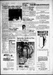
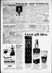
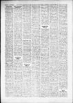
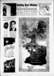
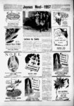
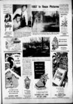
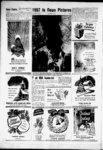
Show - V Page 22 The RR 13.50 chains to North line said section to point directly West of point of $240.81 F. & PRISCILLA S. PREECE Beg at intersection of West line of RW of OSL Ry and South line of IVi rod wide road. North 16.0 chains, .West 14 chains more or less from SE cor of NEtt of Sec 2, Tp IN, Rg 1W, SLM, West 6.50 chains to land owned by B. Ry., South 9 deg West 0.60 chs, East 308 ft to Wly RW OSL Ry. North 14 deg 37 . East 655 ft to beg. Cont. 4.97 acres $47.28 TELES PUORE PLOWE Lots 19, 20, and 37, IBlk 37, Plat Salt Lake Add, . B, North . $3.04 Cont. .22 acres I. R. ALTER Lot 12. Blk 4, Sulphur Springs Add! Cont. .086 acres $101 CLIFFORD W. WALTER W., A A. L. RUDY Beg 2688.2 ft East from SW cor of NWy of Sec 4, IN, 1W, SLM, North 188.8 ft, East 1271.8 ft South 446 ft. North 48 deg 27. West 564.5 ft, South 63 deg 42, West 900 ft. South 83 deg 29, West 199.1 ft. South 47, deg 07, West 526 ft. North 76 deg O, West 672.5 ft North 65 deg 15 .East 793 ft, North 85 dei 13' East 404.1 ft, North 2 deg 42 East 155.1 ft to beg. $18.55 Cont. 15.00 acres HAROLD R. A GLADYS MAY HOWARD Beg at a point on Wly line of a 3 rod road . South 2360 ft and West 1730 ft from NE comer of Section 11. Tp IN. Rg 1W, SLM. thence West 80 ft. South 2 deg 55 West 220 ft, East 70 ft. North IS deg 55 East 240 ft to beg. Cont. 1.01 acres W. . , . I, t . $20.26 HAROLD R. & GLADYS MAY S 24.75 HOWARD Com ft from NE cor of NWy of SEV of Sec 11. IN. 1W. SLM. South 0 deg 05 East 847.0 ft. South 89 deg 30, West 418.4 ft. North 6 deg 16, East 258.5 ft. North 10 deg 29', East 400.0 ft, South 89 deg 52. East 317.2 ft, less property conv to State 2 Road Commission in Cont 4.12 acres $14.86 R. MASON Beg on NWly side of a road at a point 877.73 ft South and 205.08 ft East and North 43 deg 32 East 173 ft along said road from NW cor Sec 12, Tp IN, Rg 1W, SLM, North 43 deg 32 East 150 ft, North 46 deg 28 West 142 ft. South 43 deg 32' West 150' ft. South 46 deg 28 East 142 ft to ter $42.2 Cont .60 acres 101-49- L. W .Si BETTY M. SOREN SON Beg South 0 deg 4 East 26.3 ft and North 89 deg 56 East 085.8 ft from NW cor 6ee 12, Tp IN, Rg 1W. SLM, North 80 deg 5 East 117.2 South 0 deg 4 East 170 ft more or less to Nly line road. South 59 deg 59 West 135.28 ft more or less to point South 0 deg 4 East of beg . . $1499.95 L. W. & BETTY E. SORENSON Beg 696.1 ft South and 139.1 ft East from NW cor Sec 12, Tp IN, Rg 1W, SLM, North 46 deg 28 West 135 ft more or less to SE side Bonn Irr, Canal Co. ft u thence approximately North 20 deg 20 East along said side canal 300 ft more or less, thence approximately South 53 deg East 140 ft. South 46 deg 28 East 120 ft South 43.32 West 300 ft to beg. Cont 128 acres .... ... $26.01 L. W. A BETTY M. SORENSON Beg on ETy line B. I. south 79 ft. east 123 ft to and on west line Hv 91 and 2N. Rg. 1W, SLM Cont. .18 56.25 ft west of SE cor Sec acres. ... $13.14 $70.25 beg. Cont. .22 acres ROLAND B. SMITH Beg at 35 Tp 5N, Rg 2W, SLM. $52.43 rtARRY A MATILDA K. north 150 ft west 160 ft LeeROY Lot 15, Blk 2, Lay-to- n A MILDRED, point of inters of south line of grantor's land and Wly south 150 feet east 160 ft to Park, Sec 1, 4N 2W, Beg 395 ft north fr .181 RW of line of 100 ft wide SE cor SWy4 Sec. 25. Tp acres beg. Conk'. 554 acres $669.40 SLM, Cont. U. S. Hy No. 91, said point 2N $128.49 Rg 1W, SLM, west BENTON M. A ISABELLA M. 178.2 ft. north 177 ft. east J. LaPHEL A ANNA N. LAUB being east 6.63 chains, .north Lot 128. Jamarl 19.25 181.5 ft. south 55 ft, east 790.5 east ft CLAY chains, Lot 17, Blk 4, Layton Acres Sec. 35, Tp 5N, Sub, 72 ft. north 99.34 ft. .south fr SW cor of NEy of Sec Park, Sec 1, 4N 2W, SLM. Cont. .22 Rg 2W, SLM, 12. 4N, 2W, SLM, north 37 88 deg 5330 east 62.25 ft, Cont. .165 acres. $160.89 acres. $17.84 W west south 0 deg 0630 west 65 CLARENCE S EARLE Lot 13, 00 R deg along Wly east 260.3 88 00 53 ft. south ft south Blk 5, Layton Park, Sec 1, BRIANT E. A DOROTHY W. deg deg 5330 0 117.81 ft. south west 210 ft south 37 deg 00. 4N 2W. SLM. Cont. .142 deg STRINGHAM Lot 211. Ja-- . $103.00 east 104.0 ft east 261.3 to acres marl Acres No. 2. in Sec. 35, $142.32 CLARENCE R. A ALENE C. MERLE F. A BYRON M. point of beg. Cont. .879 Tp 5N, Rg 2W, SLM, Cont. .. acres. $288.29 BENNION Beg on south .20 acres. $48.39 TAYLOR Lot 72 Lakevlew line st 927.63 ft south and Sub. Sec I, 4N, 2W, SLM. OSCAR M. A ROSIE B. CAR WE3TENSKOW A CLAY. south 88 deg 52 east 560.5 LOS Beg 927.63 ft north, Cont. .179 acres. INC. Lot 215 Jamarl Acres $160.52 west 807.52 ft fr SE cor of ft fr cen Sec. 25. Tp 2N, Rg WOODROW T. A DARLENE No. 2. in Sec. 33, Tp 5N, 1W. SLM, south 143.32 ft NEy4 of Sec 12. 4N. 2W. WOOD Beg 1988.42 ft east Rg 2W, SLM, Cont. .20 acres. more or less to point 236.76 SLM. south 92.7 ft, west and 33 ft South of NW cor $16.74 anothft north of north line 122.8 ft to Hy No. 91. north CULLEN G. A MAIDA Sec. 2. Tp 4N, Rg 2W, SLM. L. er st. south 89 deg 03 east east 70 ft, south 140 ft, west , 37 deg 05, west along Hy LOCKHART Lot 5. Clear151.93 ft. north 5 deg 15 115.14 ft. east 184.13 ft to 70 ft, north 140 ft to beg. field Villa Sub. Sec. 35. 4N, east 143.16 ft to south line of .beg. Cont. .425 acres. $129.95 Cont .227 acres. $10.92 2W; SLM. Cont. .157 acres. 52 said st. north 88 deg EDGAR F. A MABEL ELLA VERN B. B. DELOS. $152.15 west 165.04 ft to beg. Cont: ADAMS 1088.82 ft B. DARRELL. B A BRIART E. A ISABELLE C. Beg .52 acres. $12.10 ASHBY KENNETH W. GARDINER west, and 33 ft south of Ey4 Beg at point WilLiam a. a vesta h. cor of Sec 2, Tp 4N, Rg 2W, 1036.25 ft east fr SW cor Beg 181 ft north and McILRATH Beg at a point SLM. th south 514.98 ft to 58.25 fl west of SE cor Sec. Sec. 36. Tp 5N, Rg 2W. SLM 18.68 chains south, 3.44 north fence of OSLRR RW, 35. Tp 5N, Rg 2W; SLM. north 30 ft, west 39.25 feet, chains west fr NE cor of th south 71 deg 57. west south 30 ft, east 39.25 ft to north 30 ft. west 160 ft, 298.36 ft along fence to east NWy4 of Sec 25. 2N 1W. $.73 south 30 ft, east 160 ft to beg. Cont. .026 acres. SLM. running north 150 ft fence of DARG Ry RIW. beg. Cont. .113 acres Beg MAZIE BOHI Beg 986.25 ft to ETy line of OSLRR RW, 211 ft north and 216.25 ft th north 35 deg west 741.53 east. 119.6 ft north of SW west of SE cor Sec 35 cor of SWy4 of Sec 36. 5N. ft along fence to south line SWly along ETy line to said RIW 160 ft. east 47 ft to beg. of street th east 477.82 ft, 2W. SLM, north 83.6 ft, Tp 5N Rg 2W, SLM, north Cont more or less $5.89 150 ft west 4 ft south 150 east west 213.25 ft. south 83.6 th south 16 jieg 46 501.8 ft th east 7.0 ft th ft. east 213.25 ft to beg Cont. ft east 4 ft to beg Cont. BERTHA ROSE Beg in cen $10.92 .017 acres. Beg 211 ft north .409 acres. north 8 deg 30 west 486 ft st at point 3.2 chains west to south line of street th and 287.1 ft north of SE cor west 151.18 ft to beg cont. SWy4 Sec 25. Tp 2N. Rg 1W. 6.15 acres. Beg 387.95 ft SLM. north 45 ft, east 363 ft, west and 33 ft south fr SE west 363 ft to south cor NEy4 Sec 2. Tp 4N Rg beg. Cont. .34 acres. $16.75 2W SLM, Sly along curve to A. MULLIN E. A EVELYN HILL Beg on east line of right having radius of 739.49 ft for distance of 524 ft to road at point 332.1 ft north BEFORE AND AFTER and 2.7 chains west of SE point on present Nly RW cor of SWy4 Sec 25, Tp 2N boundry of Syracuse Branch of OSL RR as originally conRg 1W, SLM, north 62.9 ft structed; south 71 deg 57 along east line said road east west 218 ft more or less 330 ft. south 62.9 ft, west north 514.98 ft to south line 330 ft to beg. Cont. .50 acres. street east 14.02 ft south 150 $37.54 ft east 75 ft north 150 ft VERL LELAND A JEANNINE east 75 ft south 150 ft east H. HAACKE Beg NE cor 75 ft north 150 ft east 182.20 Lot 5. Ruflin Circle Sub, ft South 150 ft East 87 ft Sec. 25. Tp 2N, Rg 1W. SLM, North 150 ft. East 192.05 ft south 88 deg 52 east 5 ft, to beg Cont. 4.514 acres south O.deg 15 west 131.58 $786.24 ft. north 88 deg 52 west 5 ft to SE cor Lot 5. north WILLIAM G. KORAB Beg 1718 ft north. 1211 ft wst 0 deg 15 east 131.56 ft to fr SE cor of NEy4 of Sec beg. Cont. .008 acres. $7.45 2. 4N, 2W. SLM; west 370 MILDRED H. CAHOON Beg ft. south 60 ft, east 406 ft, at point 287.1 ft north and 2.3 chains east of SW cor NWly 70 ft to beg. Cont. .534 acres. $62.97 SEV4 Sec 25. Tp 2N. Rg 1W, SLM. east 1.6 chains, north EVA V. MADRID Beg 2 rods 107.9 ft, west 1.6 chains, west. 165 ft north fr SE cor south 107. 9. ft to beg. Cont. of SEy4 of Sec 3. 4N. 2W, .26 acres. $17.37 SLM, north 85 ft, west 158 GEORGE A DORIS L. PRD ft. south 85 ft. east 158 ft VSTGAARD Beg south 89 to beg. Cont. .31 acres. $26.94 deg 5515 west 174.91 ft and north 0 deg 07 east ELTON L. HAMBLIN Beg 1250.46 ft and north 89 deg at a point 2 rods north, 2 5900 west 524.85 ft and rods west of SE cor of Sec north 89 deg 59 west 281.80 3, 4N, 2W, SLM, running ft and south 79 deg 5930 west 10 rods north 8 rods, west 117.56 ft fr SE cor east 10 rods, south 8 rods to Sec. 25. Tp 2N, Rg 1W. SLM, ' beg. Cont. .50 acres. $19.29 th south 3 deg 2330 west MORGAN M. A DOROTHY R. 291.0 ft th north 86 deg 36 CLONTZ Beg 16.0475 chs 30 west 165 ft to State Road south fr NE cor of Sec 12, RW, th north 3 deg 2330 4N, 2W, SLM. south 1.42375 east along said RIW 172.72 chains, west 7.04 chains ft. th NETy 133.7 ft along north 1.42375 chains, east arc of a 100 ft radius curve 7.04 chains to beg. Cont 1.00 to right, th north 79 deg 59 acre. $80.81 30 east 91.2 ft to beg. Cont. JOSEPH S. A RACHEL M. .97 acres. $218.42 TALBOT Beg at a point FRANCIS HAROLD A south 547.08 ft fr NW cor of W. HAMMOND NEy4 of Sec 12. 4N. 2W. SLM. east 404.58 ft, south Beg 4 chains west, 40 ft north fr SE cor of Sec 26, 60 ft. west 404.58 ft, north) 2N. 1W, SLM, north 450 ft, 60 ft to beg. Cont. .55 acres. east 177 ft more or less to S83 22 west line of RiW of DARG RUBY RUTH HAMBLIN BAR! Now, thanks to modarit electronics, sk las ora caar In beautiful BER Beg at point north Utah Valley. Top picture shews haw smoke formerly poured from tho SWly direction along west line of said R.W to point 15.08 chain! fr SW cor NEV4 ten open hearth stacks at Geneva Works near Provo, Utah. Whoa east of beg. west to beg. Sec 12, Tp 4N, Rg 2W, SLM.1 U. S. Stool loomed that fluorine emissions from tho mill might bo $44.99 Cont. 1.10 acres. north 220.68 ft east 4.766: causing damage to soma dairy cattlo in tho area tho surrounding FLOYD Q. HATCH Beg 2.69 chains, south 47.43 ft, west a Stool Division intensivo an was plant, east program chains south. 8 chains 5 rods, south 104 rods, west fr NW cor of SWV4 of Sec 232.08 ft to beg. Cont. 1.34 launched to correct the problem caused by the high fluorine content of 36. 2N, 1W, SLM, east 5 acres. $17.47 Utah Iren ore. Solving the unique condition, first of its kind faced chains, south 9.80 chains, MORONI HAMBLIN Beg by the American steal Industry, required more than 100,000 enwest 5 chains, north 9.80 1492.92 ft north and 437.58 gineering man hours. chains to beg. Cont. 4.91 ft east fr SW cor of NEV4 bottom picture shows tho 'result of research and development $91.21 acres. Sec 12. Tp 4N-- Rg 2W, SLM. CLYDE S. A THELMA W. th south 20 ft, th west 123 costing almost $9,000,000. Electrostatic precipitators. Installed in tho MOSS hearth department, remove smoke and fluorides emanating from Beg 3.43 chains ft. th north 20 ft. th east north and south 86 deg 49 123 ft to beg Cont. .056 tho giant steelmaking furnaces. Similar equipment bos boon installed east 8.61 chains fr NE cor acres. In tho mill's sintering plant. SWW Sec 36. Tp 2N, Rg 1W RUBY HAMBLIN BARBER L SLM. south 75 ft. west 75 Beg 437.58 ft east, 1158.92 ft. north 75 ft, east 75 ft to ft north of SW cor of NEV 'of See 12, 4N, 2W. SLM. beg Cont. .12 acres. $41.88 LYNN H. A MURIAL I. CASE north 79 ft. west 123 ft. Woods Gross Town Beg at point north 89 deg 37. west 233,08 ft, north BEN E. A AFTON B. RICKS 04 east 200 ft fr point Beg at point on west line 1323.30 ft south. 670.56 ft of 4 rod wide Hy 977.63 ft west fr NE cor of SEV4 of south and 245.52 ft west fr Sec 25, Tp 2N, Rg 1W. SLM, NE cor SWy4 of Sec 25. Tp north 04 east 124.06 ft. 2N, Rg 1W, SLM, south 70.3 south 89 deg 37. east 264.10 ft. south 89 deg 15 west 334 ft. south 56 deg 53 59, west ft. north 70.3 ft, north 89 deg $9.38 265.5 15 east 334 ft to point of THEODORE C. IVY G. A Cont. or more less .536 beg. at point BURNHAM Beg acres. $65.77 on north line co. road, which VERL LELAND A JEANNINE point is north 89 deg 37 H. HAACKE Lot 5. Ruflin west 257 83 ft fr point which Circle Sub,. Sec. 25. Tp 2N. is 1323 ft south and 670.56 Cont. .20 Rg 1W, SLM. ft west fr NE cor SEV Sec acres. $12.41 25. Tp 2N. Rg 1W, SLM. JOHN E. & BIRDIE DOLAR north 89 deg 37 west 94.33 Lot 16, Ruflin Circle No. 2, ft. north 0 deg 04 east 150 Amended. Sec 25, Tp 2N, Rg ft. south 7fi deg 0525" east 1W. SLM. Cont. .21 acres, 74 82 ft to point on curve 14.27 having radius of 50 ft, Gagn CHARLES M. A DELBERT H. bears south 21 deg 4321 EGAN Beg on east line of th along said curve to east, street at point 165.0 ft west left 24 84 ft. th on curve to and 43.86 ft south and south right having radius of 20 ft 0 deg 15 west 90.89 ft fr 17.54 ft. south 0 deg 04 west NE cor of SWV'4 Sec. 25. Tp 96.03 ft to beg. Cont. .29 -- IN HOLIDAY DRESS FOR 2N, Rg 1W . SLM which acres $128.23 point is also the SW cor of W. O. CAMPBELL at Beg GRACIOUS GIVING! Lot 1, Ruflin 'Acres, south point 16 92 chains west. i 0 deg 15 west 80.0 ft along 12.21 chains south of NE east line said st. east 150 0 of Sec 25.' 2N. KENTUCKY ft. north 0 deg 15 east 80,0 , cor of SE 1W, SLM. west 3 577 chains, ft. west 150 ft to beg. Cont. south 2 842 chains, east STRAIGHT .288 acres. $53.36 3 577 chains north 7.842 W. O. CAMPBELL Beg at a! chains to beg. Cont. more or BOURBON 16.92 chains west. point less 1 09 acres. $17 51 '15.05 chains south fr NE MAUDTE of SEVi of Sec 25. 2N. 1W.1 lot 22. SLM west 14.31 rods, south pi,CA?R .1t'W Hill Johnson WE OLD SUNKY BROOK CO, LOUISVILLE, KY, DISTRIBUTED BY RATIONAL DISTILLERS PRODUCTS CO . 86 PROOF 202 ft to CJlyde W. Campbell amended Plat. See 25. To FISHER CORPORATION Beg in center of street at point 544.4 ft North and 227.7 ft West of SE cor Sec D. canal at point 26.3 ft 35, Tp 2N, Rg 1W, SLM, O 04 East and 461 South North 286.44 ft along street. ft North 89 deg 56 East and East to West line RR RW, South lideg 56 East 10.6 ft South 14 deg 18 West along and South 45 deg 14 West RR RW to point 88 deg 50 38.39 ft and South 67 deg East of beg. North 88 deg 49 West 120.1 ft and South 50 West 62.5 ft to beg. Cont. 34 deg 54 West 132.6 ft .25 acres. Beg on East line NW cor Sec 12, Tp IN, from RR RW at point 541.2 ft Rg IwrSLM, East 258.32 ft North and 66.7 ft West of to West line St., South 0 deg , SE cor Sec. 35, Tp 2N, Rg 04 East 360.58 ft more or 1W, SLM, South 88 deg 50 less to Nly line Val Verda East 66.7 ft to East line said 43 32 West South deg road, Sec. North 289.94 ft. West 30.04 ft, North 46 deg 28 30 ft to East line RR RW, 278 55 North West ft. deg South 14 deg 18 West to West 140 ft, North 27 deg Cont. .31 acres $20.94 beg. East 112 ft to beg, Cont. EDNA THOMAS HARWOOD I.- 828 acres . ... $84.44 Beg 23.07 chains South, L. W. & BETTY M. SOREN3.90 chains West from NE 4 SON Beg South 0 deg cor of SEV4 of Sec 35, 2N, East 26.5 ft and North 89 1W, SLM, East 11 rods 15 deg 56 East 705.8 ft from North 13 rods 6.5 ft, SW ft, NW cor Sec 12, Tp IN, Rg 3.50 chains more or less, 56 89 North 1W, SLM, deg South 1.50 chains to beg. East 60 ft. South 0 deg 4 Cont. .50 acres. Beg North East 83.1 ft. South 89 deg 12 East 868.75 ft and North 56 West 40 ft, South 0 deg 88 deg 58 West 301 ft, from 4 East 50 ft. North 89 deg SE cor of Sec 35, 2N, 1W, 56 East 180 ft. North 0 deg SLM, North 20, East 309.25 4 West 133.1 ft. North 89 ft. South 89 deg 22 East 226 deg 56 East 40 ft. South 0 ft South 14 deg 17 West 320 more or 260 ft deg 4 East ft. North 88 deg 58, West lesa to Nly line Val Verda 146 ft to beg. Cont. less St., road, SWly along Nly line 1.32 acres $41.54 road to point South 0 deg EDNA THOMAS HARWOOD 4 West 399 ft more or less Beg 12.55 chains South to beg. Cont. 0.98 acres NE cor of SEV4 of Sec from $27.02 33, 2N, 1W, SLM, West 3.90 R. MASON Beg on South chains, South 9.02 Chains NE line Street South 0 deg 04 15 rods. South 13 rods, 6.5 East 26.5 ft and North 89 ft. East 4 rods. North 10.52 from deg 56 East 765.8 ft chains, West 3.90 chains to NW cor Sec 12, Tp IN, Rg beg Cont. less street 3.54 1W, SLM, South 0 deg 04 acres $180.02 East 83.1 ft, North 89 deg 56 East 40 ft. South 0 deg ALVIN it AFTON P. MOSS Beg at point 26 chains 57 04 East 50 ft. North 89 deg linxs East, 12 chains 60 0 100 North 56 East ft. deg links South from NW cor of 04 West 133.1 ft. South 89 SWy4 of Sec 36, 2N, 1W, deg 56 West 140 ft to beg. SLM, South 250 ft, East 87 Cont. .376 acres. Beg South ft, North 250 ft. West 87 ft 0 deg 04 East 26.5 ft and to beg. Cont .50 acres $90.52 North 89 deg 56 East 1342 EDNA 12. THOMAS HARWOOD cor Sec NW ft from Tp Beg 12.55 chains South IN, Rg 1W, SLM. South 89 and 79.5 ft East from NW deg 56 West 239 ft along cor SWy4 Sec 36, Tp 2N, South line Street South 0 Rg 1W, SLM. South 131.70 deg 04 East 170 ft more or ft, East 37.1 ft more or less less to Nly Ln Val Verda to RR RW, South 14 deg road, NETy along Nly line 31 West along said RW to said road, to beg, Cont. .467 $299.92 acres point due South of beg North 7.45 chain! to beg. U. S. ROCK WOOL CO. Beg Cont. 1.523 acres on East line of US Hy 91 $8.44 in Davis County at point 250 ROYAL & JUNE MOSS Lot ft SW along East line of Hy 2, Moss Sub Amended, Sec from SE cor of inters of said 36, Tp 2N, Rg 1W, SLM, is Hy which SE cor Inters Cont. .18 acres $145.23 approximately East 100 ft. A JUNE MOSS Lot South 16 Vi ft from NW cor ROYAL 14, Moss Sub Amended, Sec of Sec 12, IN 1W, SLM, 36, Tp 2N, Rg 1W, SLM. SW along East line of Hy Cont. .20 acres. Also beg at 750 ft. SE 135 ft to center NWcor Lot 13, Sec 36, Tp line of Bonn htig Co. con2N, Rg 1W, SLM. South 26 crete canal NE 760 ft, NW deg 44 West 129.18 ft to 190 ft to beg. Cont, 3.00 SW cor said Lot 13, North . $447.86 acres 89 deg 38 East 8.0 ft. thence BRACK HOWARD NOBLE 23 deg 29 East 123.75 North 1342.12 South from ft Beg ft to beg. Cont. .01 acres. In NW cor EVi of NEy Sec all .21 acres $139.83 14, Tp IN, Rg 1W, SLM, & JUNE MOSS Lot South 200.62 ft West 80 ft. ROYAL 13, Moss Sub Amended Sec North 56 ft. West 300.1 ft 36, Tp 2N, Rg 1W. SLM, . more or less to East line Hy Cont. .18 acres $142.87 thence along East line Hy MARY GOPBE GIBBS, etal North 3 deg 83 East 25 ft on North side of 33 ft more or less to South line of Beg street known as Val Verda J. Howard Valentine proproad at point 1022.75 ft erty, East 190 ft. North 120 South 67.32 ft East of NW more less or 188 East ft ft. cor of Sec 12, Tp IN, Rg 1W to beg. Cont. .83 acres $10.81 SLM, which point is idenMARGARET W. SALTER tical with the SW cor of Lot Beg 17.21 chains North, 4, Block! 2, of proposed Hill35.71 Chains East from SW side Gardens Sub, and run cor of SEV4 of Sec 35, 2N, thence North 46 deg 28 1W, SLM, North 2.757 chas. West 176.9 ft. South approxWest 6.53 chains, SW 2.80 imately 31 deg, West 70 ft to 7.10 chains chains, East more or less to NW cor of beg. Cont. 1.90 acres $75.66 property deeded to Grant WALLACE R. HOWARD Tuft and recorded in Book 1 Beg 3.26 chains West from or Page 320, South 46 deg SE cor of Sec 35, 2N, 1W, 28, East 157.7 ft North 43 chains. 8.20 North SLM, deg 32, East 70 ft to beg. West 15.84 chains. South Cont. .26 acres $80.49 7.86 chains. East 15.49 chs to beg. Cont. less Ry 11.93 MARY GODBE GIBBS Beg on the North side of Val acres $86.46 Verda road at point South 43 deg 32V West 70 ft from SW cor of Lot 4, Blk 2, of proposed Hillside Garden Sub. said SW cor is located as follows: Beg on North side of Val Verda road 1022.75 ft South. 67.32 ft East of NW cor of Sec 12, Tp IN, Rg 1W, SLM, North 46 deg 28, West 157.7 ft, South 29 deg. West 77.5 ft. South 46 deg 28, East 138.2 ft to North side of Val Verda road. North 43 deg 32. East 75 ft, Cont. .26 acres $20.03 Dec. 19, 1957 REFLEX land, east 85.1 FES-SLE- R . . . T . . LIN-COL- 45-ft- , .... . . . . . . WIN-NON- Of Coarse You Want to Ghe Something GOOD, REAL GOOD! Columblo-Genev- , J Savings Banks are for all ages, particularly the younger ones. Give them a gift that will have some REAL MEANING and may DEVELOP one of the beat habits in life. We have a variety of banks in a variety of c&lors (see them in our lobby display). (THIS IS FAR LESS TUAN OUR COST.) i, 1 BANKING A .... GIFT? BARNES y CA-HOO- N , Wondering About a $1.54 EACH ft, south' 128 ft to beg. Cont, 1.64 acres. COMPANY KAYSVILLE N |