| OCR Text |
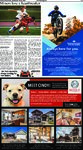
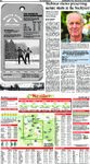
Show B-2 Sat/Sun/Mon/Tues, September 19-22, 2020 The Park Record Webinar shows preserving nature starts in the backyard Humanities Book Festival presents Doug Tallamy SCOTT IWASAKI The Park Record Part of the Swaner Preserve and EcoCenter’s mission is about restoring, preserving and researching specific and native landscapes, but according to Executive Director Nell Larson, not every landscape has to be undisturbed like the preserve. “Nature can happen in your yard, in your neighborhood or even in the city,” Larson said. “These areas all count as part of our ecosystem, and they’re still valuable.” To show how backyards can make a difference in preserving nature, the Swaner EcoCenter is partnering with the Utah Humanities Book Festival to present a free webinar with Doug Tallamy, author of “Nature’s Best Hope: A New Approach to Conservation that Starts in Your Yard” at 5:30 p.m. on Wednesday, Sept. 30, on Zoom. Visit swanerecocenter.org to register. “We love partnering with the Utah Humanities Book Festival, and we’ve been able to present many authors in person in the past, but aren’t able to do that this year, due to the pandemic,” Larson said. Tallamy, professor and chairman of the Department of Entomology and Wildlife Ecology at the University of Delaware, will discuss basic steps homeowners and renters can do to nurture nature, Larson said. Many things he will talk about will be from his book, “Nature’s Best Hope: A New Approach to Conservation that Starts in Your Yard,” which is available for purchase at the EcoCenter’s gift shop, Larson said. “Doug lays out plans for some of these actions, and what that would mean if we all do it collectively,” she said. “So many problems we face regarding the environment are large-scale when you think about climate change and loss of habitat, which makes it all feel so overwhelming. But when you hear about Doug’s research and hear him speak, you realize that there is so much that can happen in the mini ecosystems in backyards that include nesting and seeds.” The PHOTO BY ROB CARDILLO Doug Tallamy, professor and chairman of the Department of Entomology and Wildlife Ecology at the University of Delaware, will give a free webinar based on his book “Nature’s Best Hope: A New Approach to Conservation that Starts in Your Yard” at 5:30 p.m. on Wednesday, Sept. 30, on Zoom. The virtual event will be hosted by the Swaner Preserve and EcoCenter. Swaner Preserve and EcoCenter and the Utah Humanities Book Festival presents Nature’s Best Hope: A New Approach to Conservation that Starts in Your Yard” with Doug Tallamy When: 5:30 p.m. on Wednesday, Sept. 30 Where: Zoom Cost: Free Registration: https://usu-edu.zoom.us/webinar/register/ WN_wQQU7zJdRq-KHQYvCi0E4g Web: swanerecocenter.org One of the points Tallamy’s book focuses on is replacing non-native plants with native plants. “The reason that’s so important is because these native plants will attract more native insects who will use these plants as habitats,” Larson said. Native birds, in turn, can eat those native insects, and more native wildlife will follow the birds, she said. “So you start thinking about the next time you plan your garden,” Larson said. “You may want to select native plants or I will replace this tree that was uprooted by those hurricane winds that blew through Utah last week with a native tree that native moths can use as a habitat. It’s pretty simple and intuitive, and that’s what I like about it.” Larson discovered Tallamy Weather Saturday, Sept. 19 REGIONAL FORECAST FIVE DAY FORECAST FOR PARK CITY ALMANAC Park City statistics for the week ending Sept. 17 SATURDAY SUNDAY MONDAY TUESDAY WEDNESDAY Not as warm; a stray afternoon t-storm Mostly sunny Partly sunny and beautiful An afternoon thunderstorm possible Pleasant with brilliant sunshine Winds: SW 7-14 mph Winds: SW 6-12 mph Winds: SW 7-14 mph Winds: SSW 6-12 mph Winds: WNW 4-8 mph 68°/45° 71°/46° 77°/51° 75°/48° 74°/46° Temperatures: High for the week ................................ 80° Low for the week ................................. 35° Precipitation: Total for the week ............................. trace ACCUWEATHER UV INDEX TM Ogden 75/51 Elko 73/36 Salt Lake City 76/53 SUN AND MOON Sunrise Saturday ........... 7:11 a.m. ......... Sunday ............ 7:12 a.m. ......... Monday ............ 7:13 a.m. ......... Tuesday ........... 7:14 a.m. ......... Wednesday ...... 7:15 a.m. ......... Sunset 7:28 p.m. 7:26 p.m. 7:24 p.m. 7:23 p.m. 7:21 p.m. Moonrise Moonset Saturday .......... 9:45 a.m. ......... 9:10 p.m. Sunday ........... 11:01 a.m. ......... 9:44 p.m. Monday ........... 12:16 p.m. ....... 10:22 p.m. Tuesday ........... 1:29 p.m. ........ 11:06 p.m. Wednesday ...... 2:36 p.m. ........ 11:56 p.m. Full Last Price 82/50 Ely 76/34 Richfield 84/50 Moab 90/59 Cedar City 84/52 Oct 1 Oct 9 Aspen 73/46 Grand Junction 85/58 Cortez 83/48 St. George 97/65 Farmington 85/56 Page 94/66 New Grand Canyon 82/41 Sep 23 Craig 80/40 Park City Provo 75/50 MOON PHASES First Evanston 65/41 68/45 Wendover 77/48 Oct 16 Shown is Saturday’s weather. Temperatures are Saturday’s highs and Saturday night’s lows. NATIONAL CITIES City Albany Anchorage Atlanta Atlantic City Boston Buffalo Charlotte Chicago Cincinnati Cleveland Columbus, OH Dallas Denver Saturday Hi Lo W 56 33 s 56 45 c 73 56 c 65 45 pc 60 45 s 61 41 pc 69 49 c 65 49 s 66 46 s 60 42 s 64 42 s 83 60 s 90 55 pc An area of low pressure will sweep across the northern Rockies for Saturday bringing gusty winds to the region which could lead to an increased risk of fire wildfires. Some showers and even a thunderstorm are possible, especially north of Utah by Saturday afternoon. Highs from mid-50s in the mountains to 109 in the deserts. ROAD CONDITIONS REGIONAL CITIES Logan 69/37 Sat. Sun. Mon. Tue. Wed. Thu. The higher the AccuWeather UV Index™ number, the greater the need for eye and skin protection. Shown is the highest value for each day. 0-2 Low; 3-5 Moderate; 6-7 High; 8-10 High; 11+ Extreme. during a nature center conference a couple of years ago. “He was the keynote speaker, and I was super inspired by his message,” she said. “I wanted to bring him in because, like the other presenters we host, he just didn’t talk about the problems regarding the environment. He offered solutions. And I think that will resonate with our patrons and community.” Following the presentation, Larson and Hunter Klingensmith, Swaner EcoCenter visitor experience coordinator, will moderate a Q-and-A session with Tallamy. “I know all the people we at the EcoCenter talk to want to make a difference,” Larson said. “They all want to do the right thing so we can see a brighter future for planet Earth, and I think when they hear his speech, they will find some steps they can take right away.” City Aspen Boulder Butte Colorado Springs Elko Ely Evanston Flagstaff Gallup Grand Canyon Grand Junction Gunnison Idaho Falls Jackson Hole Mesquite Missoula Ogden Page Pocatello Provo Pueblo Reno Rexburg St. George Salt Lake City Spokane Sun Valley Tahoe Twin Falls Yellowstone Saturday Hi Lo W 73 46 pc 86 58 pc 57 36 t 86 55 pc 73 36 s 76 34 s 65 41 pc 77 42 s 84 46 s 82 41 s 85 58 pc 73 40 c 67 37 t 59 33 t 101 65 s 62 45 t 75 51 t 94 66 pc 70 40 sh 75 50 t 93 53 pc 77 46 s 66 42 t 97 65 s 76 53 pc 68 49 c 63 38 t 71 31 s 68 46 s 53 31 sh Sunday Hi Lo W 72 42 pc 85 59 pc 65 33 pc 84 57 pc 80 42 s 81 43 s 70 45 s 77 42 s 83 48 pc 81 42 pc 86 58 pc 74 37 pc 70 34 s 64 29 s 101 69 s 66 38 pc 77 55 s 92 66 s 73 38 s 79 52 s 91 56 s 83 51 pc 69 38 s 97 67 s 79 58 s 70 48 s 67 42 s 75 36 pc 75 47 s 56 25 pc Interstate 80: Turning out windy with more clouds for Saturday with a stray thunderstorm possible for the afternoon. US-40: A storm system passing across Idaho may touch off a thunderstorm with gusty winds Saturday. TRAVELERS FORECAST Showers and even a thunderstorm may occur to the north across Idaho and Montana Saturday; there may be gusty winds as well. Non-thunderstorm winds will be gusty across Utah and Colorado as well as northern Arizona in the afternoon. WEATHER HISTORY Honolulu, Hawaii, has never been hotter than the 95 degrees reached on Sept. 19, 1994. Many believe that areas known for tropical climates must have extreme heat. Forecasts and graphics provided by AccuWeather, Inc. ©2020 WORLD CITIES Sunday Hi Lo W 56 32 s 55 46 r 72 54 pc 64 47 s 58 48 s 62 41 s 69 49 pc 70 52 s 71 47 s 64 44 s 68 44 s 82 64 s 86 55 pc City Des Moines Detroit Dover Houston Honolulu Las Vegas Los Angeles Miami Minneapolis Nags Head New Orleans New York Norfolk Saturday Hi Lo W 70 51 pc 61 44 s 65 48 pc 88 68 s 88 78 pc 100 75 pc 88 63 pc 92 79 sh 69 53 s 72 64 c 78 72 t 64 48 s 68 61 pc Sunday Hi Lo W 74 53 pc 65 47 s 65 49 s 78 71 sh 90 76 pc 101 75 s 85 62 pc 89 78 t 73 58 pc 70 63 pc 78 72 sh 64 48 s 68 61 pc Saturday City Hi Lo W Oklahoma City 81 54 s Orlando 89 77 t Philadelphia 65 47 s Phoenix 105 78 s Pittsburgh 62 39 s Providence 63 43 s St. Louis 71 49 s San Antonio 88 65 s San Diego 82 65 pc San Francisco 74 58 pc Seattle 67 57 pc Tampa 89 77 t Washington, DC 66 50 pc Sunday Hi Lo W 79 56 s 86 74 c 66 47 s 105 79 s 64 40 s 60 45 pc 74 54 s 82 69 sh 77 65 pc 75 58 s 69 55 c 88 75 c 67 50 s City Auckland Bangkok Barbados Beijing Berlin Buenos Aires Dublin Frankfurt Hong Kong Jerusalem London Montreal Saturday Hi Lo W 60 47 pc 86 79 r 90 81 sh 84 53 pc 71 47 pc 58 46 s 59 52 pc 77 51 pc 87 79 sh 90 70 s 75 59 pc 55 38 pc Sunday Hi Lo W 62 47 pc 86 78 t 90 81 pc 82 57 c 73 47 s 64 47 s 61 50 s 76 50 pc 88 80 t 89 68 s 75 54 pc 58 40 s City Moscow Oslo Paris Rio de Janeiro Rome San Juan Seoul Sydney Tokyo Toronto Warsaw Zurich Saturday Hi Lo W 58 43 pc 64 44 s 86 63 t 88 72 c 85 64 s 89 78 s 78 55 pc 73 64 c 80 69 c 57 43 pc 66 41 pc 77 55 t Sunday Hi Lo W 54 43 pc 65 47 s 80 61 t 76 68 r 84 65 s 89 77 sh 76 54 pc 68 63 sh 74 66 r 60 43 s 68 43 s 75 54 t Weather (W): s-sunny, pc-partly cloudy, c-cloudy, sh-showers, t-thunderstorms, r-rain, sf-snow flurries, sn-snow, i-ice. |