| OCR Text |
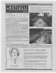
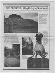
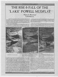
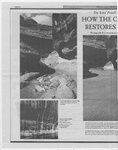
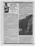
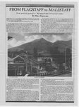
Show THE RISE 6 FALL OF THE ‘LAKE’ POWELL MUDFLAT Hope for Recovery? By Bill Wolverton My first visit to Utah Canyon Country was a trip down Coyote Gulch to the Escalante River in April, 1979, before "Lake" Powell reached full pool for the first time and ruined the Coyote - Escalante confluence. Having grown up in California and accustomed to hiking the Sierra Nevada, I was astounded. The lower half mile of Coyote and its confluence with the Escalante were especially beautiful, deep, narrow, winding, with deep overhanging bends, and...finally...the magnificent Stevens Arch in the upper walls of Navajo sandstone. About a half mile before reaching the river several huge boulders wedged between the walls presented an unclimbable dropoff, but a steep ledge on the right led past it. At the end of the ledge a rustic ladder made of a pair of driftwood logs tied together at the top, with several sticks tied across to serve as steps, offered the only way down. April 19, 1979: As it was..before I had only read of Glen Canyon ina couple of books and articles, and had no idea what it was really like. I also knew, of course, that most of it was long gone under the waters of the reservoir, which the map showed backing up to this very spot, but no further. And it became quite clear to me why Glen Canyon’s loss was so deeply mourned by those who had known it. I didn’t realize it at the time but I was hooked forever on the canyon country after that first trip. I returned in April, 1980, just before full pool level was reached in June that year, after 17 long years of filling. I came back for the third time in September, unaware of what had happened, and discovered the consequences: some 8 or 10 feet of ugly white bathtub ring and a layer of slimy muck in the streambed in lower : Atos ee we » i : THE MOUTH OF COYOTE GULCH, LOOKING AC ROSS THE ESCALANTE RIVER April 19, 1987: Because of continued high water in the reservoir, no April 11, 1995: Substantial dowacutting has occurred, most of it in inundation. sediment dowacutting has occurred in four years. The water seen here the spring of 1993, Notice reappearance of undercut in rock on left is the river flowing over the reservoir mudflat, not the reservoir itself, At the time, the reservoir was 18 feet below full pool It was quite a drop, at least 10 feet, and the ladder did not quite reach up to good footing on the ledge. Getting down required a long reach from the lowest good footing to the top end of the longer log, and a balancing act on top of it while easing down to the top step. Not exactly easy. Beyond the ladder the easy walking resumed in the shallow creek, and after several more bends the sound of rushing water announced the Escalante. Did I say rushing water? The river was literally roaring by Coyote, swollen with snowmelt runoff from a heavy winter on Boulder Mountain. Rather intimidating, to say the least. I picked my way across, slowly and carefully, in the strong current and on the rocky bottom. The scene was like nothing I could ever have imagined, even after having seen Phil Hyde’s picture of the same spot in the Sierra Club book Slickrock. I had come 12 miles from the desert starting point in Hurricane Wash, gradually descending into the earth, following the ever growing, spring fed stream and the endlessly winding, ever deepening canyon; meeting this rushing desert river in such a spectacular setting of towering red sandstone walls was almost magical. It had a feeling of wildness the likes of which I had never experienced before. The lower walls were the same beautiful Wingate sandstone which I had only seen before on numerous trips through Ruby Canyon on the California Zephyr train, but this canyon _ was far deeper and narrower, and unblemished by any manmade "improvements" “| such as the railroad. at entrance. The mudflat here has since been built back up again, due to high reservoir levels. Coyote. I couldn’t believe it at first, because the map showed the reservoir backing up the Escalante only to the mouth of Coyote and no further. But when I got home I found the Wilderness Society magazine waiting in my mail with an article by Phillip Hyde. It confirmed my worst fears: Coyote Gulch turned out to be at a lower elevation than previously believed, and had been flooded some 10 feet deep. The harm from this first brief inundation was fairly minor though. 7 In the summer of 1982 I was furloughed from my job as a Mechanical Engineer with the Southern Pacific Railroad, and the first order of business, now that I was free from employment for the moment, was another trip to the Escalante. I came back again in September and found that much of the bathtub ring had faded and summer floods had washed out the layer of slime. I came back again in both March and May of 1983, just before the big near-miss at Glen Canyon Dam (The Bureau of Reclamation over-filled the reservoir by eight vertical feet to save the spillways from being torn apart by the overflowing reservoir.). I heard about this, but I‘d seen the relatively minor effects and subsequent recovery from the first inundation, and did not expect to see much more harm. How wrong I was. In April 1984, I led a Sierra Club trip, first to Fools Canyon and then down the Escalante to Coyote. What we found as we caer Coyote was “sstcemmcreas |