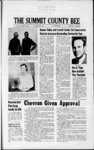
| OCR Text |
Show rods; W 15 rods; S 6 rods to beg. . . . 152.29 10 39 Phil W. & Carol Ann rods; N 6 Thomas, Kamas, Utah. Com. 172.6 ft. S of NE Cor lot 2 Blk 25 Kamas TS; th S 75 ft; W 130 ft; N 75 ft; E 130 ft to beg (error in Lot No. of Desc. 9 R 6 E SLM 126.25 fttoaptwhis 10.5 rds S of th N 10.5 rds pi of beg. to beg. . . 64.91 15 9 Edwin Verdon Street, Park Colette City, Ut. & 84060. Beg. 77 ft.EofSW Cor. Lot 1 Blk 30 Kamas 15 Townsite, run th N 130 ft; E 80.5 ft; S 130 ft W 80.5 189.38 ft to beg 12 Doris White Bagley, 5990 Indian Creek Dr. Miami Beach, Florida. 33140. Beg. at NE cor Blk 30 Kamas TS th S 59 ft; W 24 ft; S 16 ft; W 76 ft; N 22 ft; E 35 ft; N 53 ft; E 65 ft. to beg. 12.13 Nettie L. Pitt Com 147.5 ft Ut. Kamas, E of SW Cor Lot 1 Blk 45 Kamas Townsite run th E 100 ft N 147.5 ft; W 100 ft; S 147.5 ft to beg. . Hazel D. Rockhill, Allen E. Rockhill, 4374 So. 850 E., Ogden, Utah 84403. Beg. 5 rods E of SW cor lot 4 Blk 45 Kamas TS th N 10 rods; E 45 .5 ft; S 95 ft E 50 ft; S 70 ft W 95.5 ft to beg. Less 45.5 ft. x 10 rods XWD411 (KT213A) Rem ac 70.97 0.082 ac & Helen M. 25 18 Harold S. Anderson, Kamas Utah. Beg. 53.73 rds N & 5 rds W fr SW Cor NE 14 SW 14 Sec 16T2SR6E SLBM sd pt being also desc. as being 22.73 rds N of SW Cor Blk 38 Kamas TS & running th N 143 ft; E 90 ft; S 143 ftMorL to S line tract formerly 24 27 owned ' Less KT 195 A (M3-19- 0) 73.11 Dixie Jane 01en H. Thompson, Kamas, Utah. Com. N 27 rds & 2 ft fr SE Cor lot I Blk 44 Kms T S which is intersection of E line lot with - RW line Weber-ProDiversion canal; running th N 30 ft; W 250 ft. th S 120 ft; E 215 ft M or L on right or W RW line Weber Provo Diversion canal; th alg regular curve to L with a radius of 287.9 ft 104 ft M or L to beg 6.06 & 23 24 Kenneth Jolene C. Moon, Kamas, Utah. Beg. ' 7 rods W of SE cor lot 3 Blk 44 Kamas TS th W 8 23 6 & vo Henry Ray W alg line 90 ft to beg 0.295 also beg 90 ft E algS'ly S line of tract formerly owned by. Henry Ray Anderson and' wife from SW cor of sd tract which 5 rds W fr SW Cor NE SW 14 Sec 16; th E alg S line Henry Ray Anderson tract 408.96 ft M 14 6 34 30 Barker Company, 41 So 3rd E, Salt Lake City, Utah. Lot 14 Holly Park Subdivision cont. 0.278 7.85 acre 35 6 Donald & Betty J. John son, Kamas, Utah. Beg 75 rods A 500 ft So & 643.5ft E of NW Cor NW 14 Sec 21T2SR6E SLBM th S 94 ft; E 150 ft; N 94 ft; W 150 ft to beg 10.70 cont 0.32 ac 41 33 Oral A Lois W. Snapp, Oakley, Utah. Beg NO deg 02 min W 1320.0 ft fr SE cor sec 19T1SR6E SLBM th N 0 Deg 02 min W alg Town cor sec 19T1SR5E SLBM th N 0 deg 02 min W . alg Town boundary 553.0 ft; N 89 deg 47 min W 443. 0 ft; S 0 deg 02 min. E 553.0 ft; S89 deg 47 min E 433.0 ft to beg 5.192 Ac 186.47 41 36 Oral A Lois W. Snapp, Oakley, Utah. Beg 33.0 ft W of a pt N 0 deg 02 min W 1873.0 ft fr SE Cor Sec 19T1SR6E SLBM th N 1524.0 ft; W 400.0 ft; S 1524.0 ft; E 400.0 ft to beg 14.0 Ac. . 66.68 44 30 Dee Lynn Norma P. Stevens, Oakley, Utah. 44 33 Doris of SE cor NW14 SW14 Sec 20 T IS R 6E SLM th N 14 rods; W 11 12 S 14 rods rods; rods to beg cont 12 1 ac. & La-R- ue East Atkinson, So, Draper, Utah. Beg 97 ft S & 1884.5 ft S 57 deg 30 min E of NW cor Sec 29 T IS R 6E SLM th S 57 deg 30 minE 130 ft; S 13 deg 20 min W 314 ft; N 50 deg W 33 ft; N 69 deg W 160 ft; N 85 deg W 100.6 ft; N 253 ft S 57 deg 30 min E 310 ft; N. 170 ft to beg 1.7 736 12300 mas, Utah. Beg 3 rods W & 15.18 rods N of SW cor Blk 53 Kamas TS th E 40 rods; N to c1 NW 14 Sec 16; W 40 rods; S to beg cont 10 ac LESS 0.19 ac PWD 23 ALSO 2 rw acres 48 21 Parley S. LESS 6 x 15.18 VWD 54 A VWD 212. 21.24 & Rhea V. Wilde, Oakley Utah. Beg 5.4 ch N & 140 ft S 57 deg 00 min E of ctr of NW12 Sec 29 T IS R 6E SLM th S 57 deg 00 min E 170' ft; S 170 ft; N 57 deg 00 min W 170 ft N 170 ft to beg Cont 0.66 Ac... 75.24 21 49 Dewey R. A Carla W. 77.75 Orpha B. Smith, Utah. Kamas, Beg 49.5 ft & .N 106 ft of SW Cor E NW 14 NW 14 Sec 16 T2SR6E SLM th E 337 ft S 106 ft; E 175.5 ft; N 36 deg 26 min W 209.1 ft; W 384.63 ft; S 92 ft 15.34 to beg 32 3 Robert W. Shields, Kamas, Utah. Beg at pt on E line Kamas City St. S 826.03 ft A W 450.04 ft fr NE Cor Sec 21, 2S6E SLBM, th N 30 deg 07 min E 778.25 ft alg sd 11 78.48 48 18 Clifford Herbert 54.21 Cont 0.1 Ac 29 3 Harold H. Lemon, Ka 29 33 Carl E & Saxton, Oakley, Utah.Beg 851 ft W & 252.78 ft S 16 deg 25 min E & 112 ft 1 S 36 deg E of SW Cor NW14NE14 Sec 29 T IS E 6E SLM th S 36 00 min E 199 ft; N 71 30 min E 400 ft; N deg deg 57 deg rods; W 10 Thursday, December 28,1972 R 6E SLM thW 18.7 rods; N 12 rods; E 18.7 rods; S 12 rods; deg 40 min E 13.97 rods; E 10 rods to beg 356.42 cont 0.87 ac 50 27 Steven W. A Sherrie Ann Mills Georgi, Oakley, Utah. Beg on 40 ac line at pt E 1329.57 rt A S 756.6 ft fr NW Cor Sec 29 T IS R 6E SLM th S 63 deg 10 min E 154.45 ft; S 32 deg 30 min W 100.0 ft to St Road; th alg road N 57 deg 30 min W 272.33 100.0 ft 51 3 61 15 Jack R. McLain, 3259 So 7655 W, Magna, Utah. Lot 6 Plat B Weber Wild Estates SuMivision cont. 0.88 acres 26.85 56 3 Fay P. Kixkham,3687E. Lake Mead 21, Las Vegas, Nevada. Beg 40 rods S of NW CorSWl4 Sec 27 T 2S R 6E SLM th ' E 891 ft; S 700 ft; W 230 ft; S 808.5 ft; W 640 ft; N 1508.5 ft to beg cont 2 26.5 ac. Subject to R-rds x 78.5 rds FQC 434. 253.04 56 15 Clifford G. A Viola P. Dean, RFD Kamas, Utah. Beg 90 rds N of SE Cor Sec 28 T 2S R6ESLMB: th N 133 ft; W 233 ft; S 133 ft; E 233 ft to beg 53 21 W 0.711 Ac 112.86 Olen E. & Dixie Jean Thompson, RFD, Kamas, Utah. Beg 2381.28 ft S A 33 ft Efr NW CorSWl4 Sec 28 T 2S R6ESLBMth N 266.0 ft; E 215.0 ft; 5 266.0 ft; W 215.0 ft to 58.55 beg 1.31 Ac 57 30 58 0ren 9 W. & Wanda P. Smith, Kamas, Utah. Beg 36 rods of SW cor Sec 28 T 2S R 6E SLM th E 9 rods; N 18 rods; W rods rods to beg ac 7.16 59 24 Alfonzo & Belva McNeil. Francis, Utah. Beg 12 rds 13 ft E of SW Cor SW14 Sec 28 T 2S R6ESLBM; th E 4 rds; N 13 rds; W 4 rds; S 13 rds to beg cont 52 23.74 sqrds.... 59 27 Karl Ray ATamoraJudy Thompson, co Alfonzo McNeil, Francis, Utah. Beg 10 rds & 13 ft E of the SW Cor of SW14 of Sec 28 T 2S R 6E SLBM 6 running th E 2 rds; th 9 cont S 18 1.12 N 13 rds; thW2rds; thS rds to place of beg.Cont 26 sq rds. (Beg pt on 13 YWD84 in error)... 6.51 60 12 William L. A Barbara N. Prescott, Francis, Utah. Beg 3 rods W of NE Cor NE14 SE14 Sec 29 T E rds; 15 ac. S 17 rds; rds; to rds rds; beg Cont 2.28 Ac Less 0.26 S 10 W 4 Ac M32-37- 3 (FT-47- B) 38.38 Katherine J. Atkinson, RFD, Kamas, Utah. Com. 84 rds W of SE Cor Sec 29 T 2S R 6E SLBM; th 61 21 rds W 2 E ft; 6 11 ft; N 12 rds 4 rds 11 ft; S 2 rds 4 ft; rds; S 10 rds to Iwg. Cont 0.26 Ac. W 4 NW 70.81 1.4 - S 57 deg 17 min E A 67.3 ft S 23 degl2 min E & 559.7 ft S 57 deg 17 min E of Cor Sec 29 T IS R 6E SLM th S 32 deg 43 min W 162.0 ft; N 55 deg 20 min W 137.5 ft; N 32 deg 43 min E 162 ft M or L to Hwy RW; th following sd hwy S 57 deg 17 min E 137.5 ft to beg 0.51 Ac. rods to beg cont 214.99 A AtkinsonM. Katherine AtRulon J. A Doris M. kinson, RFD , Kamas, Utah. Com 84 rds W of SE Cor Sec 29 T 2S R 6E slm th W 11 rds; N 27 Margaret E Jones, Oak ley, Utah. Beg 299.05 ft 16 T 2S R 6E Coalville, Utah S 36 Beg 110 rods N & 80 rods E of SW coiSec 20 T E R 6E SLM thS 6 rods; E SLM th S 16 deg 08 min W along W Bord. 125.5 ft. th N 89 deg 49 min W 340.1 ft to SW Cor of Grantor Land Beg. th NO deg 58 min W 65 ft th S 89 deg 49 min E 65 ft th S 0 deg 58 min E 65 ft th N 89 deg 49 min W 65 ft to Place of Beg. ac W 13.97 White rods; N 14 rods; SW to 11.51 beg cont 1 ac 45 3 Patricia Cossey, Oak ley, Utah. Beg 12 rods N THE SUMMIT COUNTY BEE 12 cor Beg 2 rods W of SE 6E IS R NW14 Sec 29 T SLM th N 36 deg 40 min Bagley, 5590 Indian Creek Dr., Miami Beach, Florida. vo rd & Beg 4 rods S of NE cor SW 14 SW14 Sec 20 T 15 R 6 E SLM th S 17 12 rods; W 26 rods N 17 12 rods; E 26 rods to beg Cont 2.84 Ac 98.52 Olen and Dixie Jean Thompson, Kamas, Utah. Beg. on W Bord. Weber-ProDivision Canal at Pt. N 462.94 ft RW W 227.9 ft from E 14 17 856 & N Cor Sec. & acre 35.31 28 0.613 17.12 Company, 41 So 3rd E, Salt Lake City, Utah. Lot 13 Holly Park Subdivision cont. 0.310 alg E line 132 ft M or L to pt midway alg E bdry line sd tract; th Wly in a direct line 408.96 ft M or L to pt 131.5 ft N. of beg th S 131.5 ft to beg 1.24 Ac. th cont acre 34 27 Barker or L to SE Corsd tract; 109.85 ft th W 250.0 ft th W 346.5 ft; th S 230 ft; th E 16.5 ft; th S 109.5 ft; to a pt on the R or W right of way line of Weber Provo canal th N 51 deg. 25 min. E 267.1 ft; th alg a regular curve to the left with a radius of 287.9 ft. a distance of 52.1 to beg by Anderson et ux; th A the intersection of the E line of lot 1 with the W line of the Weber Provo Diversion canal th N 30 area and roads Holly Park Subdivision A 111.99 Thelma R. Russell, Kamas, Utah. Com SW Cor Lot 1 Blk 33 Kamas TS th N 75.5 ft; E 7.5 . rds; S 75.5 ft; W 7.5 rds to beg cont 0.22 Ac. . 44.58 20 33 Carol N. A Louise R. Van Hook, Kamas, Utah. Beg. at SE cor Lot 3 Dlk 394CTS th W 15 rd; N 8.6 rd; E 15 rd; S 8.6 rd to beg. Helen M Anderson, Kamas, Utah. In S 12 Lot 3 Blk 42 Kamas; Beg at pt on W line of N & S St. 141.5 ft S fr NE cor Blk 42 Kamas TS th S 106 ft; , W 207 ft; N 38 deg. 22 min. E 135.2 ft; E 123 ft to beg. 0.402 ac. . . 98.44 22 36 Fredrick S. A Mary. A. Longacre, Kamas, Utah. Com. at a point which is N 27 rds & 2 ft. from the SE cor of lot 1 blk 44 Kamas townsite, which is th W 8.36 52.81 cont 1.56 ac 50 18 Jack Lloyd A Twila M. Crandall, Oakley, Utah. M31-93(KT26- Bal CD640 A Less 2.71 Ac Holly ParkSubd. .19.26 33 27 Robert W. Shields, Park 243.95 beg. 24 6 Alan W. 18 12 22 30 Harold S 5.41 Ac rods; th NE 6.88 rods; E 6 rods; S 6.67 rods to Thacker', Kamas, Utah. SEly th S 30 deg 07 min W 755.16 ft; N 59 deg 53 min W 362.0 ft to beg Cont 6.36 Ac line Hwy; O'Driscoll, Kamas, Utah Beg. 16 rods N of SE COR NE 14 Sec. 17 T 2S W of NE Beg. NE Cor. Lot 3 Blk 29 Kamas TS Sur sd pt being 39 rds W & 105 rds N of SE Cor. Sec. 17 T2SR6E SLBM running th W 122 ft; S 131.5 ft; th N 54 rods; ft; W 7 rods; S 54 ft to beg. Less 8 rds 6 ft x 20 ft XWD 260. . . . 89.88 23 30 Howard A Agnes C. er, Kamas, Utah. Beg. Cor Blk ft. 29 Kamas TSthW 125.5 ft; S 6 rds; SEly 129.45 ft; N 131.5 to beg. . . . 95.58 13 33 Merlin D. & Carolyn D. W 3 rods; 40 min W 326 ft; thS 56 to deg 10 min W 260 ft beg rw line St. 14 Hwy 198; th S 56 deg min E 362.74 ft alg sd S E line to S 8.48 rods; E 9.42 rods; S 280 33 13 3o'ciaud M. AHiida Thack122 2.42 rods; NE N 6.51 6 63 Edgar T.A Ivy Hallam, Utah. Beg 529 ft 33 ft W of NE cor SE14SE14 Sec 30 T 2S R 6E SLM th N 81 deg 41 min W 215 ft; S33 deg 15 min W 669.6 ft N 14 deg 15 min E 715 ft; E 391 ft; S 164 ft to beg cont 138.88 2.6 ac D. 63 27 Amos Prescott, Clifford G. Dean, RFD, Kamas, Utah. Beg 49.5 ft W A 528 ft S of NE Cor Sec 32 T 2S R 6E SLM: th W 528 ft th 495 ft th W 247.6 ft; th S 636.2 ft; th E 198 ft; th S 660 ft to 40 line, th E on40 line 363.1 ft; th N 40 rds; th E 13 rds; th N 132 ft to Francis, N A co . beg 9.12 Ac. Less 60x125 ft conveyed Ft 63 (See Deed to Dean. M31-2- 3) 343.79 Oren W. A Wanda P. Smith, Francis, Utah. Beg 63 33 577.5 ft W A 33 ft S of NE cor Sec 32 R 2S R 6E SLM th W 60 ft; S 125 ft; E 60 ft; N 125 ft 72.21 to beg 63 39 John Walter A Leone L Prescott, Francis, Utah. Beg 111 ft W A 33 ft S fr the NE Cor of Sec 32 A running th S 57 ft; th E 61.5 ft; th S 438 ft; th W 528 ft; th N 495 ft; th E 296.5 ft th S 139 ft th E 91 ft th N 139 ft; E 79 to beg 5.65 Ac, , , , . 76.43 64 36 Warren A Fae McNeil, Francis, Utah. Beg 40 rds A 108 ft N. of SE Cor Sec 33 T 2S R 6 E SLM A run th W 400 ft; th S 108 ft th W 260 ft; th N 40 rds; th E 40 rds;' th S 132 ft; th W 135 ft; th S 82 ft; th E 135 ft; th S 338 ft to pt of beg Cont 8.76 Ac (Desc rem 65 parcel) 3 Warren H. A Fae 50.41 W Mc Neil, Kamas, Utah. Beg of NE corSEl4 SE14 Sec 33 T 2S R 6E SLM th W 135 ft; S 82 ft; E 135 ft; N 82 ft to beg 69.60 cont 0.25 ac 65 12 Warren A Fae McNeil, Kamas RFD, Utah. Beg 272 ft W of SE cor NEl4 132 ft S SEl4Sec W 63 E 63 R6Eth rds 8 ft; N 12 rds; rds 8 ft; S 12 rds to 33 T 2S 2S beg. cont 5.0 ac (3.0 ac th W out of town CD 2101). 5.85 R 6E SLBM, running 11 rods 3.75 ft; th S 20.5 rods; thSEly 31.25 ft; th due E 168 ft 8 inches M or L to a hwy; th N 362 ft MorL to beg cont 1.49 Ac 165.72 60 30 James Wayne A Bernice W. Prescott, co Ronald Jacobs, Francis, Utah. Beg 18 rods W A 2 rods W of SE cor Sec 29 T 2S 66 39 Alice Elizabeth McNeil, Ivan Atkinson, Francis, Utah. Com at a pt 709.5 ft E A 198 ft S co of the NW Cor Sec 33 T 2S R 6E SLM run th W 396 ft th S 165 ft; th W 264 ft th S 134.202 ft th E 1,026.465 ft thN 464.202 ft; th ft; th S |